
Trinity County is a county located in the U.S. state of Texas. As of the 2020 census, the population was 13,602. Its county seat is Groveton. The county is named for the Trinity River.

Sherman County is a county located in the U.S. state of Texas. As of the 2020 census, its population was 2,782. Its county seat is Stratford. The county was created in 1876 and organized in 1889. It is named for Sidney Sherman, who fought in the Texas Revolution. Though both Sherman County and Sherman, Texas, are named for the same person, the city of Sherman is located in Grayson County, about 430 miles to the southeast.

Parmer County is a county located in the southwestern Texas Panhandle on the High Plains of the Llano Estacado in the U.S. state of Texas. As of the 2020 Census, the population was 9,869. The county seat is Farwell. The county was created in 1876 and later organized in 1907. It is named in honor of Martin Parmer, a signer of the Texas Declaration of Independence and early judge. Parmer County was one of 10 prohibition, or entirely dry, counties in the state of Texas, but is now a wet county.

Motley County is a county located in the U.S. state of Texas. As of the 2020 census, its population was 1,063, making it the 10th-least populous county in Texas. Its county seat is Matador. The county was created in 1876 and organized in 1891. It is named for Junius William Mottley, a signer of the Texas Declaration of Independence. Mottley's name is spelled incorrectly because the bill establishing the county misspelled his name. Motley County was one of 30 prohibition, or entirely dry, counties in Texas, but is now a wet county.

Mitchell County is a county in the U.S. state of Texas. As of the 2020 census, its population was 8,990. Its county seat is Colorado City. The county was created in 1876 and organized in 1881. It is named for Asa and Eli Mitchell, two early settlers and soldiers in the Texas Revolution.
Madison County is a county located in the U.S. state of Texas. As of the 2020 census, its population was 13,455. Its seat is Madisonville. The county was created in 1853 and organized the next year. It is named for James Madison, the fourth President of the United States. In 1852, Hillary Mercer Crabb was elected to serve the unexpired term of State Representative F. L. Hatch. Among Crabb's accomplishments as a legislator was the introduction of a bill to create Madison County.
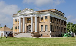
Lipscomb County is a county located in the U.S. state of Texas. As of the 2020 census, its population was 3,059. Its county seat is Lipscomb. The county was created in 1876 and organized in 1887. It is named for Judge Abner Smith Lipscomb, a secretary of state of the Republic of Texas.

Lamar County is a county located in the U.S. state of Texas, in the Northeast Texas region. As of the 2020 census, its population was 50,088. Its county seat is Paris. The county was formed by the Congress of the Republic of Texas on December 17, 1840, and organized the next year. It is named for Mirabeau B. Lamar, the second president of the Republic of Texas. Lamar County comprises the Paris, TX micropolitan statistical area.
Knox County is a county located in the U.S. state of Texas. As of the 2020 census, its population was 3,353. Its county seat is Benjamin. The county was created in 1858 and later organized in 1886. It is named for Henry Knox, an American Revolutionary War general.

Kent County is a county located in the U.S. state of Texas. As of the 2020 census, its population was 753, making it the sixth-least populous county in Texas. Its county seat is Jayton. The county was created in 1876 and later organized in 1892. It is named for Andrew Kent, who died at the Battle of the Alamo. Kent County is a prohibition or entirely dry county, one of four remaining in the state.

Hunt County is a county in the U.S. state of Texas. As of the 2020 census, its population was 99,956. Its county seat is Greenville. The county is named for Memucan Hunt, Jr., the first Republic of Texas Minister to the United States from 1837 to 1838 and the third Texas Secretary of the Navy from 1838 to 1839. Hunt County is located in Northeast Texas, at the eastern edge of the Dallas/Fort Worth Metroplex and the western edge of East Texas. Hunt County is part of the Dallas-Fort Worth-Arlington metropolitan statistical area.

Hopkins County is a county located in the U.S. state of Texas. As of the 2020 census, its population was 36,787. Its county seat is Sulphur Springs. Hopkins County is named for the family of David Hopkins, an early settler in the area. Hopkins County comprises the Sulphur Springs, TX Micropolitan Statistical Area. Hopkins County was once known as the Dairy Capital of Texas. Although dairy farms declined in the area in the late 1990s there are still a number of these located there. The Southwest Dairy Museum is located in Sulphur Springs.

Hardeman County is a county located in the U.S. state of Texas. As of the 2020 census, its population was 3,549. The county seat and largest city is Quanah. The county was created in 1858 and later organized in 1884. It is named for two brothers, Bailey Hardeman and Thomas Jones Hardeman, early Texas politicians and legislators. Hardeman County was one of 46 prohibition or entirely dry counties in the state of Texas until November 2006, when voters approved referendums to permit the legal sale of alcoholic beverages for on- and off-premises consumption.
Goliad County is a county located in the U.S. state of Texas. As of the 2020 census, the population is 7,012. Its county seat is Goliad. The county is named for Father Miguel Hidalgo; "Goliad" is an anagram, minus the silent H. The county was created in 1836 and organized the next year.

Franklin County is a county located in the U.S. state of Texas. As of the 2020 census, its population was 10,359. The county seat is Mount Vernon.

Fannin County is a county in the far northeast of the U.S. state of Texas, on the border with Oklahoma. As of the 2020 census, its population was 35,662. The county seat is Bonham.

Donley County is a county located in the U.S. state of Texas. As of the 2020 census, its population was 3,258. Its county seat is Clarendon. The county was created in 1876 and later organized in 1882.

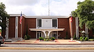
Deaf Smith County is a county located in the U.S. state of Texas. As of the 2020 census, the population was 18,583. The county seat is Hereford, which is known as the "Beef Capital of the World". The county was created in 1876 and later organized in 1890. The Hereford, TX Micropolitan Statistical Area includes all of Deaf Smith County.

Cottle County is a county in the U.S. state of Texas. As of the 2020 census, its population was 1,380. Its county seat is Paducah. The county was founded in 1876 and later organized in 1892. It is named for George Washington Cottle, who died defending the Alamo. Cottle County was formerly one of 46 prohibition, or entirely dry counties in the state of Texas. It now allows beer and wine sales.

Moore County is a county located in the U.S. state of Texas. As of the 2020 census, its population was 21,358. The county seat is Dumas. The county was created in 1876 and organized in 1892. It is named for Edwin Ward Moore, the commander of the Texas Navy. The Dumas micropolitan statistical area includes all of Moore County.


