Carson County, Texas

Last updated

Carson County
Restored filling station in Skellytown, Texas.JPG
Map of Texas highlighting Carson County.svg
Location within the U.S. state of Texas
Texas in United States.svg
Texas's location within the U.S.
Coordinates: 35°25′N101°21′W / 35.41°N 101.35°W / 35.41; -101.35
CountryFlag of the United States.svg United States
StateFlag of Texas.svg  Texas
Founded1888
Named for Samuel Price Carson
Seat Panhandle
Largest townPanhandle
Area
  Total924 sq mi (2,390 km2)
  Land920 sq mi (2,400 km2)
  Water3.9 sq mi (10 km2)  0.4%
Population
 (2020)
  Total5,807
  Density6.3/sq mi (2.4/km2)
Time zone UTC−6 (Central)
  Summer (DST) UTC−5 (CDT)
Congressional district 13th
Website www.co.carson.tx.us

Carson County is a county located in the U.S. state of Texas. As of the 2020 census, its population was 5,807. [1] [2] The county seat is Panhandle. [3] The county was founded in 1876 and later organized in 1888. [4] It is named for Samuel Price Carson, the first secretary of state of the Republic of Texas. [5]

Contents

Carson County is included in the Amarillo, TX metropolitan statistical area.

History

Native Americans

Prehistoric hunter-gatherers were the first inhabitants, followed by the Plains Apache. Modern Apache tribes followed them and were displaced by Comanches. The Comanches were defeated by the United States Army in the Red River War of 1874. [6]

Early explorations

Spanish conquistador Francisco Vásquez de Coronado explored the Llano Estacado in 1541. [7] [8]

County established and growth

Carson County was established in 1876 from Bexar County. The county was organized in 1888. Panhandle, the only town at the time, became the county seat. [9]

Ranching began to be established in the county in the 1880s. The JA Ranch encompassed over a million acres (4,000 km2) within six adjoining counties. Richard E. McNalty established the Turkey Track Ranch in 1878. [10] One of the early failed attempts came in 1882 when Charles G. Francklyn purchased 637,440 acres (2,579.6 km2) of railroad lands in adjoining counties to form the Francklyn Land and Cattle Company. The lands were later sold to the White Deer Lands Trust of British bondholders in 1886 and 1887. [11] [12]

Railroads began to reach the county by 1886 when the Atchison, Topeka and Santa Fe Railway subsidiary Southern Kansas Railway extended the line into Texas, making Panhandle City a railhead in 1888. In 1889, the Fort Worth and Denver Railway linked Panhandle City with Washburn in Armstrong County. In 1904, the Chicago, Rock Island and Gulf bought the line. In 1908, the Southern Kansas of Texas extended its line from Panhandle City to Amarillo, thus making the Kansas-Texas-New Mexico line a major transcontinental route. The Choctaw, Oklahoma and Texas Railroad built across the southern edge of the county. [13] [14]

Pumping underground water with windmills resolved the issue of bringing water from Roberts County via the railroad. [15]

White Deer in 1909 became home to Polish Catholic immigrants, who had first settled Panna Maria in Karnes County before migrating to Carson County. [16] [17]

Experimental drilling by Gulf Oil Corporation led to the county's, and the Panhandle's, first oil and gas production in late 1921. Borger field was discovered in 1925, sparking much oil exploration and production of the Panhandle area. By the end of 2000, more than 178,398,900 barrels (28,363,160 m3) of petroleum had been produced from county lands. [18] [19]

In September 1942, the Pantex Ordnance Plant was built on 16,076 acres (65.06 km2) of southwestern Carson County land, to pack and load shells and bombs in support of the World War II effort. Operations ceased August 1945, and in 1949, the site was sold to Texas Tech University at Amarillo for agricultural experimentation. Pantex reopened in 1951 as a nuclear weapons assembly plant. In 1960, Pantex began high-explosives development in support of the Lawrence Livermore National Laboratory in California. Pantex has a long-term mission to safely and securely maintain the nation's nuclear weapons stockpile and dismantle weapons retired by the military. [20] [21]

Geography

According to the U.S. Census Bureau, the county has a total area of 924 square miles (2,390 km2), of which 3.9 square miles (10 km2) (0.4%) are covered by water. [22]

Major highways

Adjacent counties

Demographics

Historical population
CensusPop.Note
1890 356
1900 46931.7%
1910 2,127353.5%
1920 3,07844.7%
1930 7,745151.6%
1940 6,624−14.5%
1950 6,8523.4%
1960 7,78113.6%
1970 6,358−18.3%
1980 6,6724.9%
1990 6,576−1.4%
2000 6,516−0.9%
2010 6,182−5.1%
2020 5,807−6.1%
U.S. Decennial Census [23]
1850–2010 [24] 2010 [25] 2020 [26]
Carson County, Texas - Demographic Profile
(NH = Non-Hispanic)
Race / EthnicityPop 2010 [25] Pop 2020 [26] % 2010% 2020
White alone (NH)5,4734,87388.53%83.92%
Black or African American alone (NH)35190.57%0.33%
Native American or Alaska Native alone (NH)56460.91%0.79%
Asian alone (NH)19190.31%0.33%
Pacific Islander alone (NH)010.00%0.02%
Some Other Race alone (NH)070.00%0.12%
Mixed Race/Multi-Racial (NH)742841.20%4.89%
Hispanic or Latino (any race)5255588.49%9.61%
Total6,1825,807100.00%100.00%

Note: the US Census treats Hispanic/Latino as an ethnic category. This table excludes Latinos from the racial categories and assigns them to a separate category. Hispanics/Latinos can be of any race.

As of the census [27] of 2000, 6,516 people, 2,470 households, and 1,884 families were residing in the county. The population density was 7 people/sq mi (2.7 people/km2). The 2,815 housing units had an average density of 3 per square mile (1.2/km2). The racial makeup of the county was 93.82% White, 0.58% African American, 1.00% Native American, 0.14% Asian, 3.06% from other races, and 1.41% from two or more races. About 7.03% of the population were Hispanics or Latinos of any race. In ancestry, 25.0% were of German, 14.2% were of Irish, 8.1% were of English, 4.7% were of American, 3.2% were of Scottish, and 3.1% were Polish.

Of the 2,470 households, 35.8% had children under living with them, 65.3% were married couples living together, 8.1% had a female householder with no husband present, and 23.7% were not families. About 22.3% of all households were made up of individuals, and 11.3% had someone living alone who was 65 or older. The average household size was 2.60, and the average family size was 3.04.

In the county, the age distribution was 27.9% under 18, 6.2% from 18 to 24, 26.3% from 25 to 44, 23.9% from 45 to 64, and 15.7% who were 65 or older. The median age was 39 years. For every 100 females, there were 95.80 males. For every 100 females age 18 and over, there were 92.20 males.

The median income for a household in the county was $40,285, and for a family was $47,147. Males had a median income of $34,271 versus $23,325 for females. The per capita income for the county was $19,368. About 5.40% of families and 7.30% of the population were below the poverty line, including 8.90% of those under age 18 and 9.40% of those age 65 or over.

Communities

Towns

Unincorporated community

Ghost towns

Education

School districts: [28]

All of the county is in the service area of Amarillo College. [29]

Politics

United States presidential election results for Carson County, Texas [30]
Year Republican Democratic Third party
No.%No.%No.%
2020 2,77989.01%2979.51%461.47%
2016 2,62088.39%2498.40%953.21%
2012 2,45188.23%29210.51%351.26%
2008 2,54885.50%40613.62%260.87%
2004 2,45083.22%48516.47%90.31%
2000 2,21680.82%48017.51%461.68%
1996 1,74263.81%74227.18%2469.01%
1992 1,64753.88%82526.99%58519.14%
1988 2,10066.71%1,03432.85%140.44%
1984 2,41274.12%82625.38%160.49%
1980 1,88864.17%1,00634.19%481.63%
1976 1,26944.94%1,54254.60%130.46%
1972 1,86875.75%56122.75%371.50%
1968 1,21145.10%90433.67%57021.23%
1964 1,04439.83%1,57460.05%30.11%
1960 1,38757.62%1,00941.92%110.46%
1956 1,06151.91%97647.75%70.34%
1952 1,47157.64%1,07141.97%100.39%
1948 41323.55%1,30174.17%402.28%
1944 44625.30%1,21668.97%1015.73%
1940 36218.10%1,63681.80%20.10%
1936 1478.51%1,56890.74%130.75%
1932 21213.23%1,39186.77%00.00%
1928 89160.04%59239.89%10.07%
1924 30632.14%61164.18%353.68%
1920 20832.15%42866.15%111.70%
1916 7818.84%32678.74%102.42%
1912 217.50%20071.43%5921.07%

See also

Related Research Articles

<span class="mw-page-title-main">Wilson County, Texas</span> County in Texas, United States

Wilson County is a county located in the U.S. state of Texas. As of the 2020 census, its population was 49,753. Its county seat is Floresville. The county is named after James Charles Wilson. Wilson County is part of the San Antonio–New Braunfels, Texas, metropolitan statistical area.

<span class="mw-page-title-main">Terrell County, Texas</span> County in Texas, United States

Terrell County is a county in the U.S. state of Texas. As of the 2020 census, its population was 760, making it the seventh-least populous county in Texas, and the 37th-least populous county in the nation. Its county seat is the census-designated place of Sanderson; no incorporated municipalities are in the county. The county was named for Alexander W. Terrell, a Texas state senator. Terrell County is one of the nine counties in the Trans-Pecos region of West Texas. It is the setting for Cormac McCarthy's novel No Country for Old Men, and the Academy Award-winning film adaptation of the same name.

<span class="mw-page-title-main">Swisher County, Texas</span> County in Texas, United States

Swisher County is a county in the U.S. state of Texas. As of the 2020 census, its population was 6,971. Its county seat is Tulia. The county was created in 1876 and later organized in 1890. It is named for James G. Swisher, a soldier of the Texas Revolution and signer of the Texas Declaration of Independence.

<span class="mw-page-title-main">Real County, Texas</span> County in Texas, United States

Real County is a county located on the Edwards Plateau in the U.S. state of Texas. As of the 2020 census, its population was 2,758. The county seat is Leakey. The county is named for Julius Real (1860–1944), a former member of the Texas State Senate. The Alto Frio Baptist Encampment is located in an isolated area of Real County southeast of Leakey.

<span class="mw-page-title-main">Reagan County, Texas</span> County in Texas, United States

Reagan County is a county on the Edwards Plateau in the U.S. state of Texas. As of the 2020 census, its population was 3,385. The county seat is Big Lake. The county is named after John Henninger Reagan (1818–1905), who was the postmaster general of the Confederate States and also a U.S. senator, U.S. representative, and first chairman of the Railroad Commission of Texas.

<span class="mw-page-title-main">Potter County, Texas</span> County in Texas, United States

Potter County is a county located in the U.S. state of Texas. As of the 2020 census, its population was 118,525. Its county seat is Amarillo. The county was created in 1876 and organized in 1887. It is named for Robert Potter, a politician, signer of the Texas Declaration of Independence, and the Texas Secretary of the Navy. Potter County is included in the Amarillo metropolitan area.

<span class="mw-page-title-main">Oldham County, Texas</span> County in Texas, United States

Oldham County is a county located in the U.S. state of Texas. As of the 2020 census, its population was 1,758. Its county seat is Vega. The county was created in 1876 and organized in 1881. Oldham County is included in the Amarillo, TX Metropolitan Statistical Area.

<span class="mw-page-title-main">Hutchinson County, Texas</span> County in Texas, United States

Hutchinson County is a county in the U.S. state of Texas. As of the 2020 census, its population was 20,617. Its county seat is Stinnett. The county was created in 1876, but not organized until 1901. It is named for Andrew Hutchinson, an early Texas attorney.

<span class="mw-page-title-main">Hansford County, Texas</span> County in Texas, United States

Hansford County is a county located in the U.S. state of Texas. As of the 2020 census, its population was 5,285. Its county seat is Spearman. The county was created in 1876 and organized in 1889. It is named for John M. Hansford, a Texas state congressman and judge.

<span class="mw-page-title-main">Hale County, Texas</span> County in Texas, United States

Hale County is a county located in the U.S. state of Texas. As of the 2020 census, its population was 32,522. Its county seat is Plainview. The county was created in 1876 and organized in 1888. It is named for Lt. John C. Hale, a hero of the Battle of San Jacinto. Hale County comprises the Plainview, Texas micropolitan statistical area.

<span class="mw-page-title-main">Dallam County, Texas</span> County in Texas, United States

Dallam County is the north-westernmost county in the U.S. state of Texas. As of the 2020 Census, its population was 7,115. Its county seat is Dalhart. The county was founded in 1876 and later organized in 1891. It is named for James Wilmer Dallam, a lawyer and newspaper publisher.

<span class="mw-page-title-main">Crosby County, Texas</span> County in Texas, United States

Crosby County is a county located in the U.S. state of Texas. As of the 2020 census, its population was 5,133. The county seat is Crosbyton. The county was founded in 1876 and later organized in 1886. Both the county and its seat are named for Stephen Crosby, a land commissioner in Texas.

<span class="mw-page-title-main">Caldwell County, Texas</span> County in Texas, United States

Caldwell County is a county located in the U.S. state of Texas. As of the 2020 census, its population was 45,883. Its county seat is Lockhart. The county was founded in 1848 and named after Mathew Caldwell, a ranger captain who fought in the Battle of Plum Creek against the Comanches and against Santa Anna's armies during the Texas Revolution. Caldwell was also a signer of the Texas Declaration of Independence.

<span class="mw-page-title-main">Armstrong County, Texas</span> County in Texas, United States

Armstrong County is a county located in the U.S. state of Texas. As of the 2020 census, the population of Armstrong County was 1,848. It is in the Texas Panhandle and its county seat is Claude.

<span class="mw-page-title-main">Groom, Texas</span> Town in Texas, United States

Groom is a town in Carson County, Texas, United States. The population was 552 at the 2020 census. It is part of the Amarillo, Texas Metropolitan Statistical Area. It is on Interstate 40 42 miles (68 km) east of Amarillo and 215 miles (346 km) west of Oklahoma City.

<span class="mw-page-title-main">Panhandle, Texas</span> Town in Texas, United States

Panhandle is the county seat of Carson County, Texas, United States. The population of the town was 2,452 at the 2010 census. Panhandle is part of the Amarillo metropolitan statistical area.

<span class="mw-page-title-main">White Deer, Texas</span> Town in Texas, United States

White Deer is a town in Carson County, Texas, United States. The population was 1,000 at the 2010 census. It is part of the Amarillo metropolitan statistical area.

<span class="mw-page-title-main">Canyon, Texas</span> City in Texas, United States

Canyon is a city in, and the county seat of, Randall County, Texas, United States. The population was 14,836 at the 2020 census. It is part of the Amarillo, Texas, metropolitan statistical area. Canyon is the home of the Panhandle–Plains Historical Museum, and the outdoor musical drama Texas.

<span class="mw-page-title-main">Texas panhandle</span> Region in Texas, United States

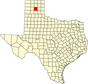
The Texas panhandle is a region of the U.S. state of Texas consisting of the northernmost 26 counties in the state. The panhandle is a square-shaped area bordered by New Mexico to the west and Oklahoma to the north and east. It is adjacent to the Oklahoma Panhandle, land which Texas previously claimed. The 1820 Missouri Compromise declared no slavery would be allowed in states admitted from the Louisiana Purchase above 36°30′ north latitude. Texas was annexed in 1845 from still more westerly land. The Compromise of 1850 removed territory north of this line from Texas, and set the border between the Texas Pandhandle and the New Mexico Territory at the 103rd meridian west. The eastern border at the 100th meridian west was inherited from the Adams–Onís Treaty of 1819, which defined the border between the United States and New Spain. The Handbook of Texas defines the southern border of Swisher County as the southern boundary of the Texas Panhandle region.

<span class="mw-page-title-main">Runnels County, Texas</span> County in Texas, United States

Runnels County is a county located in the U.S. state of Texas. As of the 2020 census, its population was 9,900. Its county seat is Ballinger. The county was created in 1858 and later organized in 1880. It is named for Hiram G. Runnels, a Texas state legislator.

References

  1. "U.S. Census Bureau QuickFacts: Carson County, Texas". United States Census Bureau. Retrieved January 31, 2022.
  2. "Carson County, Texas". United States Census Bureau . Retrieved January 30, 2022.
  3. "Find a County". National Association of Counties. Archived from the original on May 31, 2011. Retrieved June 7, 2011.
  4. "Texas: Individual County Chronologies". Texas Atlas of Historical County Boundaries. The Newberry Library. 2008. Archived from the original on May 13, 2015. Retrieved May 21, 2015.
  5. Gannett, Henry (1905). The Origin of Certain Place Names in the United States. Govt. Print. Off. p. 70.
  6. Abbe, Donald R (June 12, 2010). "Carson County, Texas". Handbook of Texas Online. Texas State Historical Association. Retrieved December 16, 2010.
  7. Lourie, Peter (2008). On the Texas Trail of Cabeza De Vaca . Boyds Mills Press. p.  46. ISBN   978-1-59078-492-1.
  8. Donoghue, David (June 15, 2010). "Francisco Vázquez de Coronado". Handbook of Texas Online. Texas State Historical Association. Retrieved December 16, 2010.
  9. "Panhandle, Texas". Texas Escapes. Texas Escapes - Blueprints For Travel, LLC. Retrieved December 16, 2010.
  10. Anderson, H Allen (June 15, 2010). "Turkey Track Ranch". Handbook of Texas Online. Texas State Historical Association. Retrieved December 16, 2010.
  11. Anderson, H. Allen (June 12, 2010). "Francklyn Land and Cattle Company". Handbook of Texas Online. Texas State Historical Association. Retrieved December 16, 2010.
  12. "Duncan Ranch History". The Duncan Ranch. Archived from the original on July 8, 2011. Retrieved December 16, 2010.
  13. "The Atchison, Topeka and Santa Fe Railway, Santa Fe All The Way!". American-Rails.com. Retrieved December 16, 2010.
  14. "The Chicago, Rock Island and Pacific Railroad, Route of the Rockets!". American-Rails.com. Retrieved December 16, 2010.
  15. "Windmills". Texas Escapes. Texas Escapes - Blueprints For Travel, LLC. Retrieved December 16, 2010.
  16. "White Deer, Texas". Texas Escapes. Texas Escapes - Blueprints For Travel, LLC. Retrieved December 16, 2010.
  17. "Panna Maria, Texas". Texas Escapes. Texas Escapes - Blueprints For Travel, LLC. Retrieved December 16, 2010.
  18. Warner, C A; Thompson, Ernest O (2007). Texas Oil & Gas Since 1543. Copano Bay Press. p. 256. ISBN   978-0-9767799-5-7.
  19. "Borger, Texas". Texas Escapes. Texas Escapes - Blueprints For Travel, LLC. Retrieved December 16, 2010.
  20. Makhijani, Arjun; Hu, Howard; Yih, Katherine (2000). Nuclear Wastelands: A Global Guide to Nuclear Weapons Production and Its Health and Environmental Effects. The MIT Press. pp. 233–239. ISBN   978-0-262-63204-1.
  21. Norris, Robert S (October 1992). "Pantex Lays Nukes to Rest". Bulletin of the Atomic Scientists: 48, 49.
  22. "2010 Census Gazetteer Files". United States Census Bureau. August 22, 2012. Retrieved April 20, 2015.
  23. "Decennial Census of Population and Housing by Decades". US Census Bureau.
  24. "Texas Almanac: Population History of Counties from 1850–2010" (PDF). Texas Almanac. Archived (PDF) from the original on October 9, 2022. Retrieved April 20, 2015.
  25. 1 2 "P2 HISPANIC OR LATINO, AND NOT HISPANIC OR LATINO BY RACE - 2010: DEC Redistricting Data (PL 94-171) - Carson County, Texas". United States Census Bureau .
  26. 1 2 "P2 HISPANIC OR LATINO, AND NOT HISPANIC OR LATINO BY RACE - 2020: DEC Redistricting Data (PL 94-171) - Carson County, Texas". United States Census Bureau .
  27. "U.S. Census website". United States Census Bureau . Retrieved May 14, 2011.
  28. "2020 CENSUS - SCHOOL DISTRICT REFERENCE MAP: Carson County, TX" (PDF). U.S. Census Bureau. Archived (PDF) from the original on October 9, 2022. Retrieved June 29, 2022. - list
  29. Texas Education Code, Sec. 130.164. AMARILLO COLLEGE DISTRICT SERVICE AREA..
  30. Leip, David. "Dave Leip's Atlas of U.S. Presidential Elections". uselectionatlas.org. Retrieved July 20, 2018.

35°25′N101°21′W / 35.41°N 101.35°W / 35.41; -101.35