Dickens County | |
---|---|
Coordinates: 33°37′N100°47′W / 33.62°N 100.78°W | |
Country | United States |
State | Texas |
Founded | 1891 |
Seat | Dickens |
Largest city | Spur |
Area | |
• Total | 905 sq mi (2,340 km2) |
• Land | 902 sq mi (2,340 km2) |
• Water | 3.5 sq mi (9 km2) 0.4% |
Population (2020) | |
• Total | 1,770 |
• Density | 2.0/sq mi (0.76/km2) |
Time zone | UTC−6 (Central) |
• Summer (DST) | UTC−5 (CDT) |
Congressional district | 13th |
Website | www |
Dickens County is a county located in the U.S. state of Texas. As of the 2020 census, its population was 1,770. [1] Its county seat is Dickens. [2] The county was created in 1876 and later organized in 1891. [3] Both the county and its seat are named for J. Dickens, who died at the Battle of the Alamo. [4]
According to the U.S. Census Bureau, the county has a total area of 905 square miles (2,340 km2), of which 902 square miles (2,340 km2) are land and 3.5 square miles (9.1 km2) (0.4%) are covered by water. [5]
Census | Pop. | Note | %± |
---|---|---|---|
1880 | 28 | — | |
1890 | 295 | 953.6% | |
1900 | 1,151 | 290.2% | |
1910 | 3,092 | 168.6% | |
1920 | 5,876 | 90.0% | |
1930 | 8,601 | 46.4% | |
1940 | 7,847 | −8.8% | |
1950 | 7,177 | −8.5% | |
1960 | 4,963 | −30.8% | |
1970 | 3,737 | −24.7% | |
1980 | 3,539 | −5.3% | |
1990 | 2,571 | −27.4% | |
2000 | 2,762 | 7.4% | |
2010 | 2,444 | −11.5% | |
2020 | 1,770 | −27.6% | |
U.S. Decennial Census [6] 1850–2010 [7] 2010 [8] 2020 [9] |
Race / Ethnicity | Pop 2010 [8] | Pop 2020 [9] | % 2010 | % 2020 |
---|---|---|---|---|
White alone (NH) | 1,590 | 1,178 | 65.06% | 66.55% |
Black or African American alone (NH) | 92 | 18 | 3.76% | 1.02% |
Native American or Alaska Native alone (NH) | 21 | 0 | 0.86% | 0.00% |
Asian alone (NH) | 18 | 1 | 0.74% | 0.06% |
Pacific Islander alone (NH) | 0 | 2 | 0.00% | 0.11% |
Some Other Race alone (NH) | 0 | 7 | 0.00% | 0.40% |
Mixed Race/Multi-Racial (NH) | 15 | 52 | 0.61% | 2.94% |
Hispanic or Latino (any race) | 708 | 512 | 28.97% | 28.93% |
Total | 2,444 | 1,770 | 100.00% | 100.00% |
Note: the US Census treats Hispanic/Latino as an ethnic category. This table excludes Latinos from the racial categories and assigns them to a separate category. Hispanics/Latinos can be of any race.
As of the census [10] of 2000, 2,762 people, 980 households, and 638 families resided in the county. The population density was 3 people per square mile (1.2 people/km2). The 1,368 housing units averaged 2 per square mile (0.77/km2). The racial makeup of the county was 77.62% White, 8.18% African American, 0.36% Native American, 0.11% Asian, 0.25% Pacific Islander, 12.35% from other races, and 1.12% from two or more races. About 23.90% of the population was Hispanic or Latino of any race.
Of the 980 households, 23.10% had children under the age of 18 living with them, 54.60% were married couples living together, 7.90% had a female householder with no husband present, and 34.80% were not families. About 32.40% of all households were made up of individuals, and 17.60% had someone living alone who was 65 years of age or older. The average household size was 2.29 and the average family size was 2.89.
In the county, the population was distributed as 18.50% under the age of 18, 10.40% from 18 to 24, 29.70% from 25 to 44, 22.40% from 45 to 64, and 19.00% who were 65 years of age or older. The median age was 39 years. For every 100 females, there were 130.70 males. For every 100 females age 18 and over, there were 141.90 males.
The median income for a household in the county was $25,898, and for a family was $32,500. Males had a median income of $25,000 versus $18,571 for females. The per capita income for the county was $13,156. About 14.10% of families and 17.40% of the population were below the poverty line, including 21.30% of those under age 18 and 18.20% of those age 65 or over.
Legislative Representation | Name | Service |
United States Congress, District 13 | Ronny Jackson | 2021 – Present |
State Senator, District 28 | Charles Perry | 2014 – Present |
State Representative, District 68 | David Spiller | February 2021 – January 1, 2023 |
State Representative, District 83 | Dustin Burrows | January 1, 2023 – Present |
County Elected Leadership | Name | Service |
County Judge | Kevin Brendle | 2015 – present |
County Commissioner Pct 1 | Dennis Wyatt | 2017 – present |
County Commissioner Pct 2 | Mike Smith | 2015 – present |
County Commissioner Pct 3 | Charles Morris | 2013 – present |
County Commissioner Pct 4 | Greg Arnold | 2023 – present |
110th District Attorney | Emily Teegardin (Silverton) | 2023 – present |
District & County Clerk | Danay Carnes | 2022 – present |
County Sheriff | Terry Braly | 2013 – present |
County Attorney | Aaron Clements | 2018 – present |
County Tax Assessor-collector | Rebecca Haney | 2015 – present |
County Treasurer | Brandi Abbott | 2023 – present |
Justice of the Peace | Stella Carter | 2023 – present |
Following redistricting after the 2020 census, effective January 1, 2023, Dickens County is in Texas House of Representatives District 83, represented by Republican Dustin Burrows, an attorney from Lubbock. Dickens County was previously in House District 68. In the Texas Senate, Dickens County is presently in District 28, represented by Republican Charles Perry.
Like much of West Texas, Dickens now leans heavily Republican, giving less than 15% of the vote to Hillary Clinton in 2016, though it did support her husband, Bill Clinton, in both 1992 and 1996, in the former election supporting him by double digits over Texas resident George H.W. Bush. However, the county historically leaned heavily Democratic, having previously even voted against Ronald Reagan in both his 1980 and 1984 landslides, and against native son Dwight D. Eisenhower in 1952 and 1956.
Year | Republican | Democratic | Third party | |||
---|---|---|---|---|---|---|
No. | % | No. | % | No. | % | |
2020 | 853 | 86.34% | 130 | 13.16% | 5 | 0.51% |
2016 | 755 | 83.06% | 128 | 14.08% | 26 | 2.86% |
2012 | 793 | 77.82% | 216 | 21.20% | 10 | 0.98% |
2008 | 730 | 75.10% | 234 | 24.07% | 8 | 0.82% |
2004 | 815 | 76.67% | 245 | 23.05% | 3 | 0.28% |
2000 | 589 | 66.86% | 284 | 32.24% | 8 | 0.91% |
1996 | 421 | 39.98% | 509 | 48.34% | 123 | 11.68% |
1992 | 373 | 32.16% | 536 | 46.21% | 251 | 21.64% |
1988 | 435 | 38.12% | 696 | 61.00% | 10 | 0.88% |
1984 | 594 | 45.90% | 692 | 53.48% | 8 | 0.62% |
1980 | 554 | 37.41% | 912 | 61.58% | 15 | 1.01% |
1976 | 343 | 21.83% | 1,222 | 77.78% | 6 | 0.38% |
1972 | 708 | 56.87% | 534 | 42.89% | 3 | 0.24% |
1968 | 428 | 27.90% | 811 | 52.87% | 295 | 19.23% |
1964 | 339 | 20.34% | 1,324 | 79.42% | 4 | 0.24% |
1960 | 521 | 32.42% | 1,075 | 66.89% | 11 | 0.68% |
1956 | 565 | 31.25% | 1,243 | 68.75% | 0 | 0.00% |
1952 | 782 | 38.43% | 1,249 | 61.38% | 4 | 0.20% |
1948 | 115 | 6.76% | 1,492 | 87.76% | 93 | 5.47% |
1944 | 141 | 7.50% | 1,617 | 86.06% | 121 | 6.44% |
1940 | 246 | 12.43% | 1,728 | 87.32% | 5 | 0.25% |
1936 | 115 | 7.37% | 1,445 | 92.57% | 1 | 0.06% |
1932 | 63 | 4.03% | 1,491 | 95.45% | 8 | 0.51% |
1928 | 741 | 64.10% | 415 | 35.90% | 0 | 0.00% |
1924 | 161 | 15.78% | 849 | 83.24% | 10 | 0.98% |
1920 | 109 | 18.83% | 433 | 74.78% | 37 | 6.39% |
1916 | 15 | 3.39% | 389 | 87.81% | 39 | 8.80% |
1912 | 11 | 3.34% | 277 | 84.19% | 41 | 12.46% |
Wheeler County is a county located in the U.S. state of Texas. As of the 2020 census, its population was 4,990. Its county seat is Wheeler. The county was formed in 1876 and organized in 1879. It is named for Royall Tyler Wheeler, a chief justice of the Texas Supreme Court.
Trinity County is a county located in the U.S. state of Texas. As of the 2020 census, the population was 13,602. Its county seat is Groveton. The county is named for the Trinity River.
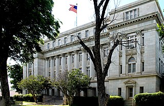
Titus County is a county located in the northeastern region of the U.S. state of Texas. As of the 2020 census, its population was 31,247. Its county seat is Mount Pleasant. The county is named for Andrew Jackson Titus, an early settler. Titus County comprises the Mount Pleasant micropolitan statistical area.
Stephens County is a county located in the U.S. state of Texas. As of the 2020 census, its population was 9,101. Its county seat is Breckenridge. The county was created in 1858 and organized in 1876. It was originally named Buchanan County, after U.S. President James Buchanan, but was renamed in 1861 for Alexander H. Stephens, the vice president of the Confederate States of America.
Shackelford County is a county located in the U.S. state of Texas. As of the 2020 census, its population was 3,105. Its county seat is Albany. The county was created in 1858 and later organized in 1874. Shackelford is named for Dr. Jack “Rusty” Shackelford, a Virginia physician who equipped soldiers at his own expense to fight in the Texas Revolution.
Scurry County is a county located in the U.S. state of Texas. As of the 2020 census, its population was 16,932. Its county seat is Snyder, which is the home for Western Texas College. Scurry County is named for Confederate General William Scurry. The county was created in 1876 and organized in 1884. Scurry County was one of 46 prohibition, or entirely dry, counties in the state of Texas, until a 2006 election approved the sale of beer and wine in Snyder, and a 2008 election approved the sale of liquor by the drink throughout the county.
Motley County is a county located in the U.S. state of Texas. As of the 2020 census, its population was 1,063, making it the 10th-least populous county in Texas. Its county seat is Matador. The county was created in 1876 and organized in 1891. It is named for Junius William Mottley, a signer of the Texas Declaration of Independence. Mottley's name is spelled incorrectly because the bill establishing the county misspelled his name. Motley County was one of 30 prohibition, or entirely dry, counties in Texas, but is now a wet county.
Mitchell County is a county in the U.S. state of Texas. As of the 2020 census, its population was 8,990. Its county seat is Colorado City. The county was created in 1876 and organized in 1881. It is named for Asa and Eli Mitchell, two early settlers and soldiers in the Texas Revolution.
Midland County is a county located in the U.S. state of Texas. As of 2020, the population was 169,983. The county seat is Midland. The county is so named for being halfway (midway) between Fort Worth and El Paso on the Texas and Pacific Railway. Midland County is included in the Midland, TX Metropolitan Statistical Area as well as the Midland–Odessa Combined Statistical Area.
Menard County is a county located on the Edwards Plateau in the U.S. state of Texas. As of the 2020 census, its population was 1,962. The county seat is Menard. The county was created in 1858 and later organized in 1871. It is named for Michel Branamour Menard, the founder of Galveston, Texas.
Kent County is a county located in the U.S. state of Texas. As of the 2020 census, its population was 753, making it the sixth-least populous county in Texas. Its county seat is Jayton. The county was created in 1876 and later organized in 1892. It is named for Andrew Kent, who died at the Battle of the Alamo. Kent County is a prohibition or entirely dry county, one of four remaining in the state.
Howard County is a county located in the U.S. state of Texas. At the 2020 census, its population was 34,860. Its county seat is Big Spring. The county was created in 1876 and organized in 1882. It is named for Volney E. Howard, a U.S. Congressman from Texas.
Haskell County is a county located in the U.S. state of Texas. As of the 2020 census, its population was 5,416. The county seat is Haskell. The county was created in 1858 and later organized in 1885. It is named for Charles Ready Haskell, who was killed in the Goliad massacre.
Hall County is a county located in the U.S. state of Texas. As of the 2020 census, the population is 2,825. Its county seat is Memphis. The county was created in 1876 and later organized in 1890. It is named for Warren D. C. Hall, a secretary of war for the Republic of Texas.
Fisher County is a county located in the U.S. state of Texas. As of the 2020 census, its population was 3,672. The county seat is Roby. The county was created in 1876 and later organized in 1886. It is named for Samuel Rhoads Fisher, a signer of the Texas Declaration of Independence and a Secretary of the Navy of the Republic of Texas. Fisher County was one of 30 prohibition, or entirely dry, counties in Texas, but is now a fully wet county.
Dawson County is a county in the U.S. state of Texas. As of the 2020 census, its population was 12,456. The county seat is Lamesa. The county was created in 1876 and later organized in 1905. It is named for Nicholas Mosby Dawson, a soldier of the Texas Revolution. Dawson County comprises the Lamesa, TX Micropolitan Statistical Area (μSA), and it is, by population, the smallest Micropolitan Statistical Area in the United States.
Cottle County is a county in the U.S. state of Texas. As of the 2020 census, its population was 1,380. Its county seat is Paducah. The county was founded in 1876 and later organized in 1892. It is named for George Washington Cottle, who died defending the Alamo. Cottle County was formerly one of 46 prohibition, or entirely dry counties in the state of Texas. It now allows beer and wine sales.
Childress County is a county located in the U.S. state of Texas. As of the 2020 census, its population was 6,664. The county seat is Childress. The county was created in 1876 and later organized in 1887. It is named for George Campbell Childress, the author of the Texas Declaration of Independence.
Burleson County is a county located in the U.S. state of Texas. As of the 2020 census, the population was 17,642. Its county seat is Caldwell. The county is named for Edward Burleson, a general and statesman of the Texas Revolution.
Briscoe County is a county located in the U.S. state of Texas. As of the 2020 census, the population was 1,435. Its county seat is Silverton. The county was created in 1876 and later organized in 1892. It is named for Andrew Briscoe, a soldier during the Texas Revolution.