Culberson County, Texas

Last updated

Culberson County
Culberson courthouse 2009.jpg
Culberson County Courthouse in Van Horn
Map of Texas highlighting Culberson County.svg
Location within the U.S. state of Texas
Texas in United States.svg
Texas's location within the U.S.
Coordinates: 31°27′N104°31′W / 31.45°N 104.52°W / 31.45; -104.52
CountryFlag of the United States.svg United States
StateFlag of Texas.svg  Texas
Founded1912
Named for David B. Culberson
Seat Van Horn
Largest townVan Horn
Area
  Total3,813 sq mi (9,880 km2)
  Land3,813 sq mi (9,880 km2)
  Water0.2 sq mi (0.5 km2)  0.01%
Population
 (2020)
  Total2,188
  Estimate 
(2022)
2,155 Decrease2.svg
  Density0.6/sq mi (0.2/km2)
Time zones
most of county UTC−6 (Central)
  Summer (DST) UTC−5 (CDT)
northwestern UTC−7 (Mountain)
  Summer (DST) UTC−6 (MDT)
Congressional district 23rd
Website www.co.culberson.tx.us

Culberson County is a county located in the U.S. state of Texas. As of the 2020 census, its population was 2,188. [1] The county seat is Van Horn. [2] Culberson County was founded in 1911 and organized the next year. [3] It is named for David B. Culberson, a Confederate soldier and U.S. representative.

Contents

Culberson County is primarily in the Central Time Zone, but northwestern Culberson County, including Guadalupe Mountains National Park, is in the Mountain Time Zone, making it one of only a few U.S. counties officially split into two time zones. It is one of the nine counties that comprise the Trans-Pecos region of West Texas.

History

Culberson County Sheriff's Office CulbersonCountySheriffTX.JPG
Culberson County Sheriff's Office

Native Americans

Prehistoric Clovis culture peoples [4] in Culberson County lived in the rock shelters and caves nestled near water supplies. These people left behind artifacts and pictographs as evidence of their presence. [5] With its treacherous topography, the area remained untouched by white explorations for centuries.

Jumano Indians led the Antonio de Espejo [6] 1582-1583 expedition near Toyah Lake on a better route to the farming and trade area of La Junta de los Ríos. Espejo's diary places the Jumano along the Pecos River and its tributaries. [7]

Antonio de Espejo was also the first white person to see the Mescalero Apache just east of the Guadalupe Mountains. The Mescalero [8] frequented the area to irrigate their crops. In 1849, John Salmon "Rip" Ford [9] explored the area between San Antonio and El Paso, noting in his mapped report the productive land upon which the Mescalero Indians farmed. By the mid-17th century, the Mescaleros expanded their territory to the Plains Navajos and Pueblos from the Guadalupes, and El Paso del Norte. Their feared presence in the area deterred white settlers. In January 1870, a group of soldiers attacked a Mescalero Apache village near Delaware Creek in the Guadalupe Mountains. In July 1880, soldiers at Tinaja de las Palmas attacked a group of Mescaleros led by Chief Victorio. [10] August 1880, buffalo soldiers ambushed Victorio at Rattlesnake Springs. Victorio retreated to Mexico and was killed in October by Mexican soldiers. [11]

Explorations

The demand for new routes from Texas to California caused an uptick in explorations. [12] The San Antonio-to-El Paso leg of the San Antonio-California Trail was surveyed in 1848 under the direction of John Coffee Hays.

Texas Commissioner Robert Simpson Neighbors [13] was sent by Governor Peter Hansborough Bell in 1850 to organize El Paso.

Lt. Francis Theodore Bryan [14] camped at Guadalupe Pass while exploring a route from San Antonio to El Paso via Fredericksburg. Upon reaching El Paso in July 1849, his report recommended sink wells along the route. In July 1848, Secretary of War William L. Marcy wanted a military post established on the north side of the Rio Grande. Major Jefferson Van Horne [15] was sent out in 1849 to establish Marcy's goal.

John Russell Bartlett, [16] [17] was commissioned in 1850 to carry out the Treaty of Guadalupe Hidalgo. Bartlett declared the Guadalupe Mountains dark and gloomy, and proposed a transcontinental railroad be built south of the peaks. Three years later, Captain John Pope [18] was sent to scout out a railroad route, and in the succeeding year to search for artesian water supplies.

The San Antonio-San Diego Mail Line and the Butterfield Overland Mail [19] both serviced the area 1857–1861. These mail coaches provided a means for travelers to reach California in 27 days if the passenger had the $200 for a one-way fare and was courageous enough to withstand the weather and dangers en route. [20]

Rival railway companies began competing for rights of way. The Texas and Pacific Railway [21] and the Galveston, Harrisburg and San Antonio Railway [22] eventually reached an agreement to share the tracks.

County established and growth

Van Horn City-County Library VanHornCityCountyLibrary.JPG
Van Horn City-County Library

Culberson County was established in 1911 from El Paso County and named after David B. Culberson. [23] The county was organized in 1912. Van Horn became the county seat. [24]

With the opening of the railways, ranchers began to settle in the county. Lobo was settled in part due to misrepresentation by promoters. A class-action lawsuit by the residents forced the promoters to build the Lobo Hotel. Unfortunately, the area was struck by two powerful earthquakes [25] - one in 1929, and the 6.0 quake near Valentine that was felt as far away as Dallas. The hotel was destroyed. [26]

Guadalupe Mountains National Park [27] [28] was established in 1972. President Lyndon B. Johnson signed the 1966 legislation to create the park. Stipulation was made that all mineral, oil, and gas rights had to be ceded to the federal government.

Space exploration

Blue Origin, the space vehicle development company founded by Jeff Bezos, maintains a suborbital launch site about 25 miles north of Van Horn, Texas.

Geography

Culberson County Hospital and Van Horn Rural Clinic Culberson County Hospital - Van Horn, Texas November 2013.JPG
Culberson County Hospital and Van Horn Rural Clinic

According to the United States Census Bureau, the county has a total area of 3,813 square miles (9,880 km2), of which 3,813 square miles (9,880 km2) are land and 0.2 square miles (0.52 km2) (0.01%) is covered by water. [29] It is the fifth-largest county by area in Texas. The largest part of Guadalupe Mountains National Park lies in the northwestern corner of the county, including McKittrick Canyon and Guadalupe Peak, the highest natural point in Texas at 8,751 ft (2,667 m).

Major highways

U.S. Highway 90 south of Van Horn US 90 Van Horn.jpg
U.S. Highway 90 south of Van Horn

Adjacent counties

National protected areas

Demographics

Historical population
CensusPop.Note
1920 912
1930 1,22834.6%
1940 1,65334.6%
1950 1,82510.4%
1960 2,79453.1%
1970 3,42922.7%
1980 3,315−3.3%
1990 3,4072.8%
2000 2,975−12.7%
2010 2,398−19.4%
2020 2,188−8.8%
2022 (est.)2,155 [30] −1.5%
U.S. Decennial Census [31]
1850–2010 [32] 2010–2020 [1]
Culberson County racial/ethnic composition [33] [34]
(NH = Non-Hispanic) [lower-alpha 1]
RacePop 2010Pop 2020% 2010% 2020
White (NH)50444521.02%20.34%
Black or African American (NH)8200.33%0.91%
Native American or Alaska Native (NH)13110.54%0.5%
Asian (NH)22280.92%1.28%
Some Other Race (NH)030.0%0.14%
Mixed/Multi-Racial (NH)24361.0%1.65%
Hispanic or Latino 1,8271,64576.19%75.18%
Total2,3982,188

As of the 2020 United States census, there were 2,188 people, 668 households, and 400 families residing in the county.

As of the census [37] of 2000, 2,975 people, 1,052 households, and 797 families resided in the county. The population density was less than 1/km2 (2.6/sq mi). The 1,321 housing units were at a density less than one per square mile (0/km2). The racial makeup of the county was 68.94% White, 0.71% African American, 0.47% Native American, 0.57% Asian, 27.13% from other races, and 2.18% from two or more races. About 72.24% of the population were Hispanic or Latino of any race.

Of the 1,052 households, 39.10% had children under the age of 18 living with them, 58.20% were married couples living together, 13.50% had a female householder with no husband present, and 24.20% were not families. About 21.50% of all households were made up of individuals, and 7.40% had someone living alone who was 65 years of age or older. The average household size was 2.82 and the average family size was 3.30.

In the county, the population was distributed as 32.20% under the age of 18, 7.80% from 18 to 24, 25.80% from 25 to 44, 23.00% from 45 to 64, and 11.20% who were 65 years of age or older. The median age was 33 years. For every 100 females, there were 102.70 males. For every 100 females age 18 and over, there were 97.10 males.

The median income for a household in the county was $25,882, and for a family was $28,547. Males had a median income of $22,500 versus $14,817 for females. The per capita income for the county was $11,493. About 21.50% of families and 25.10% of the population were below the poverty line, including 30.20% of those under age 18 and 19.40% of those age 65 or over.

Communities

Town

Unincorporated communities

Ghost town

Education

All of the county is in the Culberson County-Allamoore Independent School District. [38]

All of the county is in the service area of Odessa College. [39]

Politics

Like most counties in heavily Hispanic South Texas, Culberson County leans Democratic. The last Republican presidential candidate to carry the county was George W. Bush in 2004, who drew even with Kerry among Hispanic voters in the state.

United States presidential election results for Culberson County, Texas [40]
Year Republican Democratic Third party
No.%No.%No.%
2020 41548.03%43850.69%111.27%
2016 28036.51%45459.19%334.30%
2012 29533.56%56864.62%161.82%
2008 25733.86%49264.82%101.32%
2004 40751.65%37547.59%60.76%
2000 41340.81%57757.02%222.17%
1996 32926.51%80464.79%1088.70%
1992 25129.63%42450.06%17220.31%
1988 41742.46%55756.72%80.81%
1984 50955.51%40744.38%10.11%
1980 54155.43%42343.34%121.23%
1976 37347.40%40751.72%70.89%
1972 55569.12%23829.64%101.25%
1968 29838.55%33042.69%14518.76%
1964 31439.90%47360.10%00.00%
1960 30046.15%34352.77%71.08%
1956 32454.36%26945.13%30.50%
1952 33156.78%25243.22%00.00%
1948 3812.42%24479.74%247.84%
1944 176.77%20079.68%3413.55%
1940 4512.89%30386.82%10.29%
1936 238.78%23991.22%00.00%
1932 185.92%28593.75%10.33%
1928 7245.86%8554.14%00.00%
1924 1512.82%9379.49%97.69%
1920 612.77%4085.11%12.13%
1916 21.57%12497.64%10.79%
1912 00.00%145100.00%00.00%

See also

Related Research Articles

<span class="mw-page-title-main">Reeves County, Texas</span> County in the United States

Reeves County is a county located in the U.S. state of Texas. As of the 2020 census, its population was 14,748. Its county seat and most populous city is Pecos. The county was created in 1883 and organized the next year. It is named for George R. Reeves, a Texas state legislator and colonel in the Confederate Army. It is one of the nine counties that comprise the Trans-Pecos region of West Texas. Reeves County comprises the Pecos micropolitan statistical area.

<span class="mw-page-title-main">Presidio County, Texas</span> County in Texas, United States

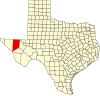
Presidio County is a county located in the U.S. state of Texas. As of the 2020 census, its population was 6,131. Its county seat is Marfa. The county was created in 1850 and later organized in 1875. Presidio County is in the Trans-Pecos region of West Texas and is named for the border settlement of Presidio del Norte. It is on the Rio Grande, which forms the Mexican border.

<span class="mw-page-title-main">Kinney County, Texas</span> County in Texas, United States

Kinney County is a county located in the U.S. state of Texas. As of the 2020 census, its population was 3,129. Its county seat is Brackettville. The county was created in 1850 and later organized in 1874. It is named for Henry Lawrence Kinney, an early settler.

<span class="mw-page-title-main">Jeff Davis County, Texas</span> County in Texas, United States

Jeff Davis County is a county in the U.S. state of Texas. As of the 2020 census, its population was 1,996. Its county seat is Fort Davis. The county is named for Jefferson Davis, who served as the 23rd United States Secretary of War in the 1850s, and as Confederate president.

<span class="mw-page-title-main">Hudspeth County, Texas</span> County in Texas, United States

Hudspeth County is a county located in the U.S. state of Texas. As of the 2020 census, the population was 3,202. Its county seat is Sierra Blanca, and the largest community is Fort Hancock. The county is named for Claude Benton Hudspeth, a state senator and United States Representative from El Paso. It is northeast of the Mexico–U.S. border.

<span class="mw-page-title-main">Guadalupe County, Texas</span> County in Texas, United States

Guadalupe County is a county located in the U.S. state of Texas. As of the 2020 census, its population was 172,706. The county seat is Seguin. The county was founded in 1846 and is named after Guadalupe River.

<span class="mw-page-title-main">El Paso County, Texas</span> County in Texas, United States

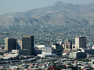
El Paso County is the westernmost county in the U.S. state of Texas. As of the 2020 census, the population was 865,657, making it the ninth-most populous county in the state of Texas. Its seat is the city of El Paso, the sixth-most populous city in Texas and the 22nd-most populous city in the United States. The county was created in 1850 and later organized in 1871.

<span class="mw-page-title-main">Comal County, Texas</span> County in Texas, United States

Comal County is a county located on the Edwards Plateau in the U.S. state of Texas. As of the 2020 census, its population was 161,501. Comal County is known for its rich German-Texan and European history. Its county seat is New Braunfels.

<span class="mw-page-title-main">Brewster County, Texas</span> County in Texas, United States

Brewster County is a county located in the U.S. state of Texas. It is in West Texas and its county seat is Alpine. It is one of the nine counties that comprise the Trans-Pecos region, and borders Mexico. Brewster County is the largest county by area in the state - at 6,192 square miles (16,040 km2) it is over three times the size of the state of Delaware, and more than 500 square miles (1,300 km2) bigger than Connecticut.

<span class="mw-page-title-main">Van Horn, Texas</span> Town in Texas, United States

Van Horn is a town in and the seat of Culberson County, Texas, United States. According to the 2010 census, Van Horn had a population of 2,063, down from 2,435 at the 2000 census. The 2020 census results detailed a decline in population to 1,941. Van Horn's official newspaper is The Van Horn Advocate. The town is the westernmost incorporated community in the United States that uses the Central Time Zone, located on the same line of longitude as Cheyenne, Wyoming, and Colorado Springs, Colorado. Its earliest sunset in the beginning of December is the latest among incorporated towns in the United States, occurring no earlier than 5:56 pm.

<span class="mw-page-title-main">El Paso, Texas</span> City in Texas, United States

El Paso is a city in and the county seat of El Paso County, Texas, United States. The 2020 population of the city from the U.S. Census Bureau was 678,815, making it the 22nd-most populous city in the U.S., the most populous city in West Texas, and the sixth-most populous city in Texas. Its metropolitan statistical area covers all of El Paso and Hudspeth counties in Texas, and had a population of 868,859 in 2020.

<span class="mw-page-title-main">Presidio, Texas</span> City in Texas, United States

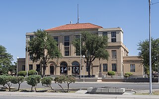
Presidio is a city in Presidio County, Texas, United States. It is situated on the Rio Grande River, on the opposite side of the U.S.–Mexico border from Ojinaga, Chihuahua. The name originates from Spanish and means "fortress". The population was 4,169 at the 2000 census, and had increased to 4,426 as of the 2010 US census.

<span class="mw-page-title-main">Edwards Plateau</span> Geographic and ecological region of Texas, United States

The Edwards Plateau is a geographic region forming the crossroads of Central, South and West Texas, United States. It is named in honor of Haden Edwards. It is bounded by the Balcones Fault to the south and east; the Llano Uplift and the Llano Estacado to the north; and the Pecos River and Chihuahuan Desert to the west. San Angelo, Austin, San Antonio and Del Rio roughly outline the area. The plateau, especially its southeast portion, is also known as the Texas Hill Country.

<span class="mw-page-title-main">Mescalero</span> Native American tribe in New Mexico

Mescalero or Mescalero Apache is an Apache tribe of Southern Athabaskan–speaking Native Americans. The tribe is federally recognized as the Mescalero Apache Tribe of the Mescalero Apache Reservation, located in south-central New Mexico.

<span class="mw-page-title-main">El Capitan (Texas)</span> Mountain in the US state of Texas

El Capitan is a peak in Culberson County, Texas, located within Guadalupe Mountains National Park. The 10th-highest peak in Texas at 8,085 ft, El Capitan is part of the Guadalupe Mountains, an exposed portion of a Permian period reef uplifted and exposed by tectonic activity during the late Cretaceous period. The southern terminus of the Guadalupe Mountains, El Capitan looms over U.S. 62/180, where its imposing height and stark outline have made it one of the iconic images of the Trans-Pecos to generations of travelers.

<span class="mw-page-title-main">Trans-Pecos</span> Far west region in US state of Texas

The Trans-Pecos, as originally defined in 1887 by the Texas geologist Robert T. Hill, is the distinct portion of Texas that lies west of the Pecos River. The term is considered synonymous with Far West Texas, a subdivision of West Texas. The Trans-Pecos is part of the Chihuahuan Desert, the largest desert in North America. It is the most mountainous and arid portion of the state, and most of its vast area is sparsely populated. Among the nine counties in the region are the five largest counties by area in Texas and eight of the eleven largest in the state. The area is known for the natural environment of the Big Bend and the gorge of the Rio Grande, part of which has been designated a National Wild and Scenic Rivers System. With the notable exceptions of Big Bend Ranch State Park, Big Bend National Park and the Guadalupe Mountains National Park, the vast majority of the Trans-Pecos region consists of privately owned ranchland. However, most of the region's population reside in the El Paso metropolitan area. Besides El Paso and its metropolitan area, the major cities are Pecos (12,916), Fort Stockton (8,466), and Alpine (6,035). All other settlements have under 5,000 people.

The Suma were an Indigenous people of Aridoamerica. They had two branches, one living in the northern part of the Mexican state of Chihuahua and the other living near present-day El Paso, Texas. They were semi-nomadic hunter-gatherers who practiced little or no agriculture. The Suma merged with Apache groups and the mestizo population of northern Mexico, and are extinct as a distinct people.

Antonio de Espejo (1540–1585) was a Spanish explorer who led an expedition, accompanied by Diego Perez de Luxan, into New Mexico and Arizona in 1582–83. The expedition created interest in establishing a Spanish colony among the Pueblo Indians of the Rio Grande valley.

<span class="mw-page-title-main">Lobo, Texas</span> Ghost town in Culberson County, Texas, United States

Lobo is a ghost town in Culberson County, Texas, United States, that was abandoned in 1991.

Carnoviste was a southern (Guadalupe) Mescalero chief, his band—presumably Tsehitcihéndé or Niit'ahénde—lived in the Texan Big Bend Country, ranging on both sides of the Rio Grande from the Guadalupe Mountains towards east of the Limpia Mountains onto the edge of the Southern Plains.

References

  1. 1 2 "State & County QuickFacts". United States Census Bureau. Retrieved December 18, 2023.
  2. "Find a County". National Association of Counties. Archived from the original on May 31, 2011. Retrieved June 7, 2011.
  3. "Texas: Individual County Chronologies". Texas Atlas of Historical County Boundaries. The Newberry Library. 2008. Archived from the original on May 13, 2015. Retrieved May 21, 2015.
  4. Mallouf, Robert J. "Exploring the Past in Trans-Pecos Texas". Sul Ross University. Archived from the original on May 27, 2010. Retrieved April 30, 2010. Texas Beyond History
  5. "Artistic Expression". Texas Beyond History. Retrieved April 30, 2010. Texas Beyond History
  6. Blake, Robert Bruce: de Espejo, Antonio from the Handbook of Texas Online. Retrieved April 30, 2010. Texas State Historical Association
  7. "Who Were The Jumano?". Texas Beyond History. Retrieved April 30, 2010. Texas Beyond History
  8. "Texas Indians Map". R E. Moore and Texarch Associates. Retrieved April 30, 2010. R E. Moore and Texarch Associates
  9. Connor, Seymour V: Ford, John Salmon from the Handbook of Texas Online. Retrieved April 30, 2010. Texas State Historical Association
  10. Stout, Joseph A. "Chief Victorio". King Snake. Retrieved April 30, 2010.
  11. Davis, Stanford L. "Victorio's War". Buffalo Soldier. Archived from the original on September 21, 2007. Stanford L. Davis, M.A.
  12. Kohout, Martin Donell: Culberson County from the Handbook of Texas Online. Retrieved April 30, 2010. Texas State Historical Association.
  13. Richardson, Rupert N: Neighbors, Robert Simpson from the Handbook of Texas Online. Retrieved April 30, 2010. Texas State Historic
  14. Powell, William S: Bryan, Francis Theodore from the Handbook of Texas Online. Retrieved April 30, 2010. Texas State Historical Association
  15. Kohout, Martin Donell: Van Horne, Jefferson from the Handbook of Texas Online. Retrieved April 30, 2010. Texas State Historical Association
  16. Faulk, Odie B: Bartlett, John Russell from the Handbook of Texas Online. Retrieved April 30, 2010. Texas State Historical Association
  17. "Bartlett, John Russell". The John Russell Bartlett Society. Retrieved April 30, 2010.
  18. Cutrer, Thomas W: Pope, John from the Handbook of Texas Online. Retrieved April 30, 2010. Texas State Historical Association
  19. "San Antonio-San Diego Mail". State of California Parks Department. Retrieved April 30, 2010.
  20. "San Antonio-California Trail". Texas Historical Marker. Archived from the original on March 14, 2012. Retrieved April 30, 2010.
  21. "Texas and Pacific Railway". Texas and Pacific Railway. Retrieved April 30, 2010.
  22. "Galveston, Harrisburg and San Antonio Railway". Texas Transportation Museum. Archived from the original on September 30, 2011. Retrieved April 30, 2010.
  23. Hooker, Anne W: Culberson, David Browning from the Handbook of Texas Online. Retrieved April 30, 2010. Texas State Historical Association
  24. "Van Horn, Texas". Texas Escapes - Blueprints For Travel, LLC. Retrieved April 30, 2010. Texas Escapes - Blueprints For Travel, LLC.
  25. "Texas Earthquakes". Institute for Geophysics. Archived from the original on April 3, 2010. Retrieved April 30, 2010.
  26. "Lobo, Texas". Lobo, Texas. Retrieved April 30, 2010.
  27. "Guadalupe Mountains National Park". National Park Service. Retrieved April 30, 2010.
  28. Maliszkiewctz, Mark: Guadalupe Mountains National Park from the Handbook of Texas Online. Retrieved April 30, 2010. Texas State Historical Association
  29. "2010 Census Gazetteer Files". United States Census Bureau. August 22, 2012. Retrieved April 21, 2015.
  30. "Annual Estimates of the Resident Population for Counties: April 1, 2020 to July 1, 2022". Census.gov . Retrieved December 18, 2023.
  31. "U.S. Decennial Census". United States Census Bureau. Retrieved March 26, 2015.
  32. "Texas Almanac: Population History of Counties from 1850–2010" (PDF). Texas Almanac. Archived (PDF) from the original on October 9, 2022. Retrieved April 21, 2015.
  33. "Explore Census Data". data.census.gov. Retrieved May 19, 2022.
  34. "Explore Census Data". data.census.gov. Retrieved May 19, 2022.
  35. http://www.census.gov [ not specific enough to verify ]
  36. "About the Hispanic Population and its Origin". www.census.gov. Retrieved May 18, 2022.
  37. "U.S. Census website". United States Census Bureau . Retrieved May 14, 2011.
  38. "2020 CENSUS - SCHOOL DISTRICT REFERENCE MAP: Culberson County, TX" (PDF). United States Census Bureau. Archived (PDF) from the original on October 9, 2022. Retrieved June 28, 2022. - Text list
  39. Texas Education Code, Section 130.193, "Odessa College District Service Area".
  40. Leip, David. "Dave Leip's Atlas of U.S. Presidential Elections". uselectionatlas.org. Retrieved July 21, 2018.
  1. Note: the US Census treats Hispanic/Latino as an ethnic category. This table excludes Latinos from the racial categories and assigns them to a separate category. Hispanics/Latinos can be of any race. [35] [36]

31°27′N104°31′W / 31.45°N 104.52°W / 31.45; -104.52