Brown County, Texas

Last updated

Brown County
Brown County Courthouse (1 of 1).jpg
The Brown County Courthouse in Brownwood
Map of Texas highlighting Brown County.svg
Location within the U.S. state of Texas
Texas in United States.svg
Texas's location within the U.S.
Coordinates: 31°46′N99°00′W / 31.77°N 99°W / 31.77; -99
CountryFlag of the United States.svg United States
StateFlag of Texas.svg  Texas
Founded1858
Named for Henry Stevenson Brown
Seat Brownwood
Largest cityBrownwood
Area
  Total957 sq mi (2,480 km2)
  Land944 sq mi (2,440 km2)
  Water13 sq mi (30 km2)  1.3%
Population
 (2020)
  Total38,095
  Density40/sq mi (15/km2)
Time zone UTC−6 (Central)
  Summer (DST) UTC−5 (CDT)
Congressional district 11th
Website www.browncountytx.gov

Brown County is a county in west-central Texas. As of the 2020 census, the population was 38,095. [1] [2] Its county seat is Brownwood. [3] The county was founded in 1856 and organized in 1858. [4] It is named for Henry Stevenson Brown, a commander at the Battle of Velasco, an early conflict between Texians and Mexicans.

Contents

The Brownwood, TX Micropolitan Statistical Area includes all of Brown County.

History

Indigenous peoples lived here for thousands of years before Europeans entered the area. The historic inhabitants were the Penteka (also known to the Europeans as Comanche), who occupied this area at the time of European colonization. [5] In 1721, the Marqués de San Miguel de Aguayo expedition is said to have passed through the county. [6]

In 1838, land surveys were made of the area. [5] In 1856, Welcome W. Chandler from Mississippi became the first settler, arriving with his family, John H. Fowler, and seven slaves. They built a log cabin on Pecan Bayou. The county was formed from Comanche and Travis Counties. It is named after Henry Stevenson Brown, an American pioneer from Kentucky. [5] [7] In 1858, the county was formally organized. [7] Brownwood was designated as the county seat. [8]

In 1874, John Wesley Hardin and gang celebrated his 21st birthday in Brown and Comanche Counties. Deputy Charles Webb drew his gun, provoking a gunfight that ended Webb's life. A lynch mob was formed, but Hardin and his family were put into protective custody. The mob broke into the jail and hanged his brother Joe and two cousins. Hardin fled. [9] The Fort Worth-Brownwood stage was robbed five times in two months of 1875. [5] Oil was discovered on the H. M. Barnes farm near Grosvenor in 1879. [5] Texas Rangers killed two fence cutters in 1886, in the ongoing battle between farmers and ranchers over fencing open range. [5] By the next year, cotton had become the county's most important crop. [5] Pulitzer-Prize winner Katherine Ann Porter was born in 1890 at Indian Creek. [10] The Fort Worth and Rio Grande Railway was built to the county in 1892. [5] [11] The Gulf, Colorado and Santa Fe Railway was built into Brownwood in 1895. [5] In 1903, the GC&SF extended the line to Menard.

Also in 1903, the county voted itself a dry county. Alcohol did not become legal again until the 1950s. [5]

In 1909, the boll weevil moved into the county, destroying the cotton economy. [5] The first commercial production of oil came from the efforts of Jack Pippen at Brownwood in 1917. [5] The first large field began producing from a depth of 1,100 feet (340 m) in 1919 near Cross Cut. [5] In 1926, an oil boom followed the success of the White well on Jim Ned Creek; some 600 wells were drilled in several fields in the county during this time. [5] By 1991, more than 50,561,000 barrels (8,038,600 m3) of oil had been taken from Brown County lands since 1917. [5]

In 1940, work began on Camp Bowie. [12] The first German prisoners of war arrived in 1943; many had been members of Erwin Rommel's Afrika Korps. [13]

In 1889, Howard Payne College [14] and Daniel Baker College [15] were established in Brownwood. They combined under the name Howard Payne College in 1953. [5]

Geography

According to the U.S. Census Bureau, the county has a total area of 957 sq mi (2,480 km2), of which 13 sq mi (34 km2) (1.3%) are covered by water. [16]

Major highways

Adjacent counties

Demographics

Historical population
CensusPop.Note
1860 244
1870 544123.0%
1880 8,4141,446.7%
1890 11,42135.7%
1900 16,01940.3%
1910 22,93543.2%
1920 21,682−5.5%
1930 26,38221.7%
1940 25,924−1.7%
1950 28,60710.3%
1960 24,728−13.6%
1970 25,8774.6%
1980 33,05727.7%
1990 34,3714.0%
2000 37,6749.6%
2010 38,1061.1%
2020 38,0950.0%
U.S. Decennial Census [17]
1850–2010 [18] 2010 [19] 2020 [20]
Brown County, Texas - Demographic Profile
(NH = Non-Hispanic)
Race / EthnicityPop 2010 [19] Pop 2020 [20] % 2010% 2020
White alone (NH)28,47826,67274.73%70.01%
Black or African American alone (NH)1,3031,3533.42%3.55%
Native American or Alaska Native alone (NH)1701340.45%0.35%
Asian alone (NH)1602690.42%0.71%
Pacific Islander alone (NH)14270.04%0.07%
Some Other Race alone (NH)36960.09%0.25%
Mixed Race/Multi-Racial (NH)4921,3331.29%3.50%
Hispanic or Latino (any race)7,4538,21115.95%21.55%
Total38,10638,095100.00%100.00%

Note: the US Census treats Hispanic/Latino as an ethnic category. This table excludes Latinos from the racial categories and assigns them to a separate category. Hispanics/Latinos can be of any race.

As of the census [21] of 2000, 37,674 people, 14,306 households, and 10,014 families resided in the county. The population density was 40 people per square mile (15 people/km2). The 17,889 housing units averaged 19 units per square mile (7.3/km2). The racial makeup of the county was 87.35% White, 4.01% Black or African American, 0.53% Native American, 0.37% Asian, 6.08% from other races, and 1.66% from two or more races. About 15.38% of the population was Hispanic or Latino of any race.

Of the 14,306 households in the county, 31.40% had children under the age of 18 living with them, 55.90% were married couples living together, 10.90% had a female householder with no husband present, and 30.00% were not families. About 26.50% of all households were made up of individuals, and 12.40% had someone living alone who was 65 years of age or older. The average household size was 2.48 and the average family size was 2.98.

In the county, the population was distributed as 25.80% under the age of 18, 10.10% from 18 to 24, 24.70% from 25 to 44, 22.90% from 45 to 64, and 16.40% who were 65 years of age or older. The median age was 37 years. For every 100, there were 97.40 males. For every 100 females age 18 and over, there were 93.10 males.

The median income for a household in the county was $30,974, and for a family was $37,725. Males had a median income of $30,169 versus $19,647 for females. The per capita income for the county was $15,624. About 14.00% of families and 17.20% of the population were below the poverty line, including 22.70% of those under age 18 and 12.10% of those age 65 or over.

Media

The Brownwood Bulletin is the local daily newspaper, an American Consolidated Media company that also serves media online through its website. Brown County is part of the Abilene/Sweetwater/Brownwood television media market. Area television stations include KRBC-TV, KTXS-TV, KXVA, KTAB-TV, and KIDU-LD.

Communities

Cities

Town

Census-designated places

Unincorporated communities

Ghost towns

Politics

Brown County is a state bellwether for Texas in U.S. presidential elections, having voted for the statewide winner in every presidential election since the county's formation in 1858. It shares this status along with Aransas County, Lampasas County, Parker County, Shackelford County, and Young County.

United States presidential election results for Brown County, Texas [22]
Year Republican Democratic Third party
No.%No.%No.%
2020 13,69885.78%2,10713.19%1641.03%
2016 12,01785.68%1,62111.56%3882.77%
2012 11,89585.29%1,90413.65%1481.06%
2008 12,05279.95%2,82218.72%2001.33%
2004 11,64081.67%2,52317.70%900.63%
2000 9,60974.37%3,13824.29%1731.34%
1996 6,52455.35%4,13835.11%1,1259.54%
1992 5,31342.07%4,26433.76%3,05324.17%
1988 6,81058.68%4,76341.04%330.28%
1984 8,46867.29%4,07032.34%470.37%
1980 6,51556.41%4,86742.14%1671.45%
1976 4,48344.41%5,57755.25%350.35%
1972 5,99072.76%2,17126.37%720.87%
1968 2,99734.84%3,99946.49%1,60618.67%
1964 2,07028.38%5,21471.49%90.12%
1960 3,51248.26%3,72051.11%460.63%
1956 3,66453.26%3,19546.44%210.31%
1952 4,63555.02%3,77844.85%110.13%
1948 1,07116.53%5,05978.06%3515.42%
1944 43012.13%2,42668.45%68819.41%
1940 66312.76%4,52387.06%90.17%
1936 44810.05%3,97189.08%390.87%
1932 3307.54%4,02491.98%210.48%
1928 2,03350.46%1,99249.44%40.10%
1924 3969.99%3,46787.48%1002.52%
1920 39716.30%1,70870.11%33113.59%
1916 1817.95%1,98687.22%1104.83%
1912 1156.81%1,43384.84%1418.35%

See also

Related Research Articles

<span class="mw-page-title-main">Young County, Texas</span> County in Texas, United States

Young County is a county located in the U.S. state of Texas. As of the 2020 census, its population was 17,867. Its county seat is Graham. The county was created in 1856 and organized in 1874. It is named for William Cocke Young, an early Texas settler and soldier.

<span class="mw-page-title-main">Yoakum County, Texas</span> County in Texas, United States

Yoakum County is a county located in the far western portion of the U.S. state of Texas. As of the 2020 census, the population was 7,694. Its county seat is Plains. The county was created in 1876 and later organized in 1907. It is named for Henderson King Yoakum, a Texas historian.

<span class="mw-page-title-main">Terry County, Texas</span> County in Texas, United States

Terry County is a county located in the U.S. state of Texas. As of the 2020 census, its population was 11,831. Its county seat is Brownfield. The county was demarked in 1876 and organized in 1904. It is named for Benjamin Franklin Terry, a colonel in the Confederate Army. Terry County was one of 46 dry counties in the state of Texas, but is now a moist county. Terry County is one of the most productive pumpkin producing counties in the United States.

<span class="mw-page-title-main">Somervell County, Texas</span> County in Texas, United States

Somervell County is a county on the Edwards Plateau in the U.S. state of Texas. As of the 2020 census, its population was 9,205. Its county seat is Glen Rose. The county is named for Alexander Somervell, secretary of war for the Republic of Texas.

<span class="mw-page-title-main">Palo Pinto County, Texas</span> County in Texas, United States

Palo Pinto County is a county located in the U.S. state of Texas. As of the 2020 census, its population was 28,409. The county seat is Palo Pinto. The county was created in 1856 and organized the following year.

<span class="mw-page-title-main">McCulloch County, Texas</span> County in Texas, United States

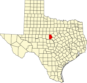
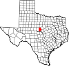
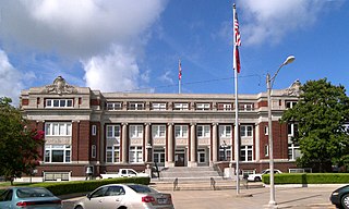
McCulloch County is a county located on the Edwards Plateau in the U.S. state of Texas. At the 2020 census, its population was 7,630. Its county seat is Brady. The county was created in 1856 and later organized in 1876. It is named for Benjamin McCulloch, a famous Texas Ranger and Confederate general.

<span class="mw-page-title-main">Mason County, Texas</span> County in Texas, United States

Mason County is a rural county located on the Edwards Plateau in the U.S. state of Texas. At the 2020 census, its population was 3,953. Its county seat is Mason. The county is named for Fort Mason, which was located in the county.

<span class="mw-page-title-main">Limestone County, Texas</span> County in the United States

Limestone County is a county in the U.S. state of Texas. As of the 2020 census, its population was 22,146. Its county seat is Groesbeck. The county was created in 1846.

<span class="mw-page-title-main">Kerr County, Texas</span> County in Texas, United States

Kerr County is a county located on the Edwards Plateau in the U.S. state of Texas. As of the 2020 census, its population was 52,598. Its county seat is Kerrville. The county was named by Joshua D. Brown for his fellow Kentucky native, James Kerr, a congressman of the Republic of Texas. The Kerrville, TX Micropolitan Statistical Area includes all of Kerr County.

<span class="mw-page-title-main">Hutchinson County, Texas</span> County in Texas, United States

Hutchinson County is a county in the U.S. state of Texas. As of the 2020 census, its population was 20,617. Its county seat is Stinnett. The county was created in 1876, but not organized until 1901. It is named for Andrew Hutchinson, an early Texas attorney.

<span class="mw-page-title-main">Hardin County, Texas</span> County in Texas, United States

Hardin County is a county located in the U.S. state of Texas, United States. As of the 2020 census, its population was 56,231. The county seat is Kountze. The county is named for the family of William Hardin from Liberty County, Texas.

<span class="mw-page-title-main">Hansford County, Texas</span> County in Texas, United States

Hansford County is a county located in the U.S. state of Texas. As of the 2020 census, its population was 5,285. Its county seat is Spearman. The county was created in 1876 and organized in 1889. It is named for John M. Hansford, a Texas state congressman and judge.

<span class="mw-page-title-main">Hamilton County, Texas</span> County in Texas, United States

Hamilton County is a county located on the Edwards Plateau in the U.S. state of Texas. As of the 2020 census, its population was 8,222. The county seat is Hamilton. The county was created in 1858. It is named for James Hamilton Jr., a former governor of South Carolina who gave financial aid to the Republic of Texas.

<span class="mw-page-title-main">Falls County, Texas</span> County in Texas, United States

Falls County is a county in the U.S. state of Texas. As of the 2020 census, its population was 16,968. The county seat is Marlin. It is named for the original 10-foot-tall waterfall on the Brazos River, which existed until the river changed course during a storm in 1866. The present falls is two miles northeast of the original falls, at the Falls on the Brazos Park, a camping site only a few miles out of Marlin on Farm to Market Road 712.

<span class="mw-page-title-main">Eastland County, Texas</span> County in Texas, United States

Eastland County is a county located in central West Texas. As of the 2020 census, its population was 17,725. The county seat is Eastland. The county was founded in 1858 and later organized in 1873. It is named for William Mosby Eastland, a soldier during the Texas Revolution and the only officer to die as a result of the "Black Bean executions" of the Mier Expedition.

<span class="mw-page-title-main">Crosby County, Texas</span> County in Texas, United States

Crosby County is a county located in the U.S. state of Texas. As of the 2020 census, its population was 5,133. The county seat is Crosbyton. The county was founded in 1876 and later organized in 1886. Both the county and its seat are named for Stephen Crosby, a land commissioner in Texas.

<span class="mw-page-title-main">Comanche County, Texas</span> County in Texas, United States

Comanche County is a county located on the Edwards Plateau in Central Texas. As of the 2020 census, its population was 13,594. The county seat is Comanche. The county was founded in 1856 and is named for the Comanche Native American tribe.

<span class="mw-page-title-main">Coleman County, Texas</span> County in Texas, United States

Coleman County is a county located in the U.S. state of Texas. As of the 2020 census, its population was 7,684. The county seat is Coleman. The county was founded in 1858 and organized in 1864. It is named for Robert M. Coleman, a signer of the Texas Declaration of Independence and soldier at the Battle of San Jacinto.

<span class="mw-page-title-main">Burnet County, Texas</span> County in Texas, United States

Burnet County is a county located on the Edwards Plateau in the U.S. state of Texas. As of the 2020 census, its population was 49,130. Its county seat is Burnet. The county was founded in 1852 and later organized in 1854. It is named for David Gouverneur Burnet, the first (provisional) president of the Republic of Texas. The name of the county is pronounced with the emphasis or accent on the first syllable, just as is the case with its namesake.

<span class="mw-page-title-main">Blanco County, Texas</span> County in Texas, United States

Blanco County is a United States county located in the U.S. state of Texas. It is located in Central Texas and its county seat is Johnson City.

References

  1. "U.S. Census Bureau QuickFacts: Brown County, Texas". United States Census Bureau. Retrieved January 31, 2022.
  2. "Brown County, Texas". United States Census Bureau . Retrieved February 23, 2021.
  3. "Find a County". National Association of Counties. Archived from the original on May 31, 2011. Retrieved June 7, 2011.
  4. "Texas: Individual County Chronologies". Texas Atlas of Historical County Boundaries. The Newberry Library. 2008. Archived from the original on May 13, 2015. Retrieved May 20, 2015.
  5. 1 2 3 4 5 6 7 8 9 10 11 12 13 14 15 16 Leffler, John. "Brown County, Texas". Handbook of Texas Online. Texas State Historical Society. Retrieved November 30, 2010.
  6. Chipman, Donald E; Joseph, Harriet Denise (1999). Notable Men and Women of Spanish Texas. University of Texas Press. pp. 83–102. ISBN   978-0-292-71218-8.
  7. 1 2 Aston, B W; Taylor, Ira Donathon (1997). Along the Texas Forts Trail. University of North Texas Press. p. 120. ISBN   978-1-57441-035-8.
  8. "Brownwood, Texas". Texas Escapes. Texas Escapes - Blueprints For Travel, LLC. Retrieved November 30, 2010.
  9. Metz, Leon Claire (1998). "Charlie Webb Goes Down". John Wesley Hardin: Dark Angel of Texas. University of Oklahoma Press. pp. 133–138. ISBN   978-0-8061-2995-2.
  10. "Indian Creek, Texas". Texas Escapes. Texas Escapes - Blueprints For Travel, LLC. Retrieved November 30, 2010.
  11. Duncan, Patrick L. "Fort Worth and Rio Grande Railway". Handbook of Texas Online. Texas State Historical Association. Retrieved November 30, 2010.
  12. White, Lonnie J. "Camp Bowie". Handbook of Texas Online. Texas State Historical Association. Retrieved November 30, 2010.
  13. Hurt, PhD, R Douglas (2008). The Great Plains during World War II. University of Nebraska Press. pp. 312–347. ISBN   978-0-8032-2409-4.
  14. Lively, Jeannie F. "Howard Payne University". Handbook of Texas Online. Texas State Historical Association. Retrieved November 30, 2010.
  15. Temple, Louann Atkins. "Daniel Baker College". Handbook of Texas Online. Texas State Historical Association. Retrieved November 30, 2010.
  16. "2010 Census Gazetteer Files". United States Census Bureau. August 22, 2012. Retrieved April 19, 2015.
  17. "Decennial Census of Population and Housing by Decade". US Census Bureau.
  18. "Texas Almanac: Population History of Counties from 1850–2010" (PDF). Texas Almanac. Archived (PDF) from the original on October 9, 2022. Retrieved April 19, 2015.
  19. 1 2 "P2 HISPANIC OR LATINO, AND NOT HISPANIC OR LATINO BY RACE - 2010: DEC Redistricting Data (PL 94-171) - Brown County, Texas". United States Census Bureau .
  20. 1 2 "P2 HISPANIC OR LATINO, AND NOT HISPANIC OR LATINO BY RACE - 2020: DEC Redistricting Data (PL 94-171) - Brown County, Texas". United States Census Bureau .
  21. "U.S. Census website". United States Census Bureau . Retrieved May 14, 2011.
  22. Leip, David. "Dave Leip's Atlas of U.S. Presidential Elections". uselectionatlas.org. Retrieved July 19, 2018.

31°46′N99°00′W / 31.77°N 99.00°W / 31.77; -99.00