Mitchell County, Texas

Last updated

Mitchell County
Mitchell County Courthouse September 2020.jpg
The Mitchell County Courthouse in Colorado City
Map of Texas highlighting Mitchell County.svg
Location within the U.S. state of Texas
Texas in United States.svg
Texas's location within the U.S.
Coordinates: 32°18′N100°55′W / 32.3°N 100.92°W / 32.3; -100.92
CountryFlag of the United States.svg United States
StateFlag of Texas.svg  Texas
Founded1881
Seat Colorado City
Largest cityColorado City
Area
  Total916 sq mi (2,370 km2)
  Land911 sq mi (2,360 km2)
  Water4.8 sq mi (12 km2)  0.5%
Population
 (2020)
  Total8,990
  Density9.8/sq mi (3.8/km2)
Time zone UTC−6 (Central)
  Summer (DST) UTC−5 (CDT)
Congressional district 19th
Veterans Monument in Mitchell County Veterans Monument, Mitchell County, TX IMG 4524.JPG
Veterans Monument in Mitchell County
Mitchell County Public Library Mitchell County, TX, Public LibraryIMG 4529.JPG
Mitchell County Public Library

Mitchell County is a county in the U.S. state of Texas. As of the 2020 census, its population was 8,990. [1] Its county seat is Colorado City. [2] The county was created in 1876 and organized in 1881. [3] It is named for Asa and Eli Mitchell, two early settlers and soldiers in the Texas Revolution.

Contents

Geography

According to the U.S. Census Bureau, the county has a total area of 916 square miles (2,370 km2), of which 911 sq mi (2,360 km2) are land and 4.8 sq mi (12 km2) (0.5%) are covered by water. [4] Mitchell County contains two reservoirs, Lake Colorado City and Lake Champion.

Major highways

Adjacent counties

Demographics

Historical population
CensusPop.Note
1880 117
1890 2,0591,659.8%
1900 2,85538.7%
1910 8,956213.7%
1920 7,527−16.0%
1930 14,18388.4%
1940 12,477−12.0%
1950 14,35715.1%
1960 11,255−21.6%
1970 9,073−19.4%
1980 9,0880.2%
1990 8,016−11.8%
2000 9,69821.0%
2010 9,403−3.0%
2020 8,990−4.4%
U.S. Decennial Census [5]
1850–2010 [6] 2010 [7] 2020 [8]
Mitchell County, Texas - Demographic Profile
(NH = Non-Hispanic)
Race / EthnicityPop 2010 [7] Pop 2020 [8] % 2010% 2020
   White alone (NH)4,7534,32850.55%48.14%
   Black or African American alone (NH)1,04392511.09%10.29%
   Native American or Alaska Native alone (NH)44340.47%0.38%
Asian alone (NH)27540.29%0.60%
Pacific Islander alone (NH)010.00%0.01%
Some Other Race alone (NH)10110.11%0.12%
Mixed Race/Multi-Racial (NH)451830.48%2.04%
Hispanic or Latino (any race)3,4813,45437.02%38.42%
Total9,4038,990100.00%100.00%

Note: the US Census treats Hispanic/Latino as an ethnic category. This table excludes Latinos from the racial categories and assigns them to a separate category. Hispanics/Latinos can be of any race.

As of the census [9] of 2000, 9,698 people, 2,837 households, and 1,997 families resided in the county. The population density was 11 people per square mile (4.2 people/km2). The 4,168 housing units averaged five per square mile (2/km2). The racial makeup of the county was 74.52% White, 12.81% Black or African American, 0.41% Native American, 0.36% Asian, 0.02% Pacific Islander, 10.19% from other races, and 1.69% from two or more races; 31.03% of the population was Hispanic or Latino of any race.

Of the 2,837 households, 30.60% had children under the age of 18 living with them, 55.60% were married couples living together, 11.40% had a female householder with no husband present, and 29.60% were not families; 27.50% of all households were made up of individuals, and 15.50% had someone living alone who was 65 years of age or older. The average household size was 2.48 and the average family size was 3.00.

In the county, the population was distributed as 19.80% under the age of 18, 11.50% from 18 to 24, 30.70% from 25 to 44, 22.90% from 45 to 64, and 15.10% who were 65 years of age or older. The median age was 39 years. For every 100 females, there were 159.30 males. For every 100 females age 18 and over, there were 174.40 males.

The median income for a household in the county was $25,399, and for a family was $31,481. Males had a median income of $23,750 versus $20,221 for females. The per capita income for the county was $14,043. About 15.00% of families and 17.70% of the population were below the poverty line, including 22.90% of those under age 18 and 20.90% of those age 65 or over.

Communities

Cities

Town

Census-designated place

Unincorporated communities

Ghost towns

Politics

United States presidential election results for Mitchell County, Texas [10]
Year Republican Democratic Third party
No.%No.%No.%
2020 2,17084.14%39715.39%120.47%
2016 1,78081.06%35416.12%622.82%
2012 1,75675.82%53823.23%220.95%
2008 1,81574.66%58624.11%301.23%
2004 1,91274.75%63924.98%70.27%
2000 1,70866.36%83732.52%291.13%
1996 94939.46%1,21350.44%24310.10%
1992 1,12836.47%1,35343.74%61219.79%
1988 1,59647.27%1,77352.52%70.21%
1984 2,00759.79%1,33239.68%180.54%
1980 1,45549.73%1,44649.42%250.85%
1976 1,05837.73%1,73061.70%160.57%
1972 1,79071.83%69928.05%30.12%
1968 89329.96%1,58953.30%49916.74%
1964 73723.33%2,42076.61%20.06%
1960 1,20836.06%2,13163.61%110.33%
1956 1,09136.59%1,89163.41%00.00%
1952 1,41740.95%2,03158.70%120.35%
1948 2309.26%2,18187.80%732.94%
1944 2188.47%2,21586.09%1405.44%
1940 2519.45%2,40190.37%50.19%
1936 1928.61%2,03591.21%40.18%
1932 1489.02%1,49090.85%20.12%
1928 1,09959.57%74640.43%00.00%
1924 16911.69%1,24285.89%352.42%
1920 8910.47%69481.65%677.88%
1916 394.23%80387.00%818.78%
1912 192.69%57381.05%11516.27%

See also

Related Research Articles

<span class="mw-page-title-main">Titus County, Texas</span> County in Texas, United States

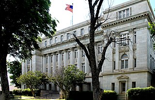
Titus County is a county located in the northeastern region of the U.S. state of Texas. As of the 2020 census, its population was 31,247. Its county seat is Mount Pleasant. The county is named for Andrew Jackson Titus, an early settler. Titus County comprises the Mount Pleasant micropolitan statistical area.

<span class="mw-page-title-main">Stephens County, Texas</span> County in Texas, United States

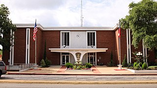
Stephens County is a county located in the U.S. state of Texas. As of the 2020 census, its population was 9,101. Its county seat is Breckenridge. The county was created in 1858 and organized in 1876. It was originally named Buchanan County, after U.S. President James Buchanan, but was renamed in 1861 for Alexander H. Stephens, the vice president of the Confederate States of America.

<span class="mw-page-title-main">Shackelford County, Texas</span> County in Texas, United States

Shackelford County is a county located in the U.S. state of Texas. As of the 2020 census, its population was 3,105. Its county seat is Albany. The county was created in 1858 and later organized in 1874. Shackelford is named for Dr. Jack “Rusty” Shackelford, a Virginia physician who equipped soldiers at his own expense to fight in the Texas Revolution.

<span class="mw-page-title-main">Scurry County, Texas</span> County in Texas, United States

Scurry County is a county located in the U.S. state of Texas. As of the 2020 census, its population was 16,932. Its county seat is Snyder, which is the home for Western Texas College. Scurry County is named for Confederate General William Scurry. The county was created in 1876 and organized in 1884. Scurry County was one of 46 prohibition, or entirely dry, counties in the state of Texas, until a 2006 election approved the sale of beer and wine in Snyder, and a 2008 election approved the sale of liquor by the drink throughout the county.

<span class="mw-page-title-main">San Jacinto County, Texas</span> County in Texas, United States

San Jacinto County is a county in the U.S. state of Texas. As of the 2020 census, its population was 27,402. Its county seat is Coldspring. The county's name comes from the Battle of San Jacinto which secured Texas' independence from Mexico and established a republic in 1836.

<span class="mw-page-title-main">Parmer County, Texas</span> County in Texas, United States

Parmer County is a county located in the southwestern Texas Panhandle on the High Plains of the Llano Estacado in the U.S. state of Texas. As of the 2020 Census, the population was 9,869. The county seat is Farwell. The county was created in 1876 and later organized in 1907. It is named in honor of Martin Parmer, a signer of the Texas Declaration of Independence and early judge. Parmer County was one of 10 prohibition, or entirely dry, counties in the state of Texas, but is now a wet county.

<span class="mw-page-title-main">Madison County, Texas</span> County in Texas, United States

Madison County is a county located in the U.S. state of Texas. As of the 2020 census, its population was 13,455. Its seat is Madisonville. The county was created in 1853 and organized the next year. It is named for James Madison, the fourth President of the United States. In 1852, Hillary Mercer Crabb was elected to serve the unexpired term of State Representative F. L. Hatch. Among Crabb's accomplishments as a legislator was the introduction of a bill to create Madison County.

<span class="mw-page-title-main">Lipscomb County, Texas</span> County in Texas, United States

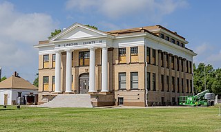
Lipscomb County is a county located in the U.S. state of Texas. As of the 2020 census, its population was 3,059. Its county seat is Lipscomb. The county was created in 1876 and organized in 1887. It is named for Judge Abner Smith Lipscomb, a secretary of state of the Republic of Texas.

<span class="mw-page-title-main">Jackson County, Texas</span> County in Texas, United States

Jackson County is a county in the U.S. state of Texas. As of the 2020 census its population was 14,988. Its county seat is Edna. The county was created in 1835 as a municipality in Mexico and in 1836 was organized as a county. It is named for Andrew Jackson, President of the United States from 1829 to 1837.

<span class="mw-page-title-main">Howard County, Texas</span> County in Texas, United States

Howard County is a county located in the U.S. state of Texas. At the 2020 census, its population was 34,860. Its county seat is Big Spring. The county was created in 1876 and organized in 1882. It is named for Volney E. Howard, a U.S. Congressman from Texas.

<span class="mw-page-title-main">Hockley County, Texas</span> County in Texas, United States

Hockley County is a county located in the U.S. state of Texas. As of the 2020 census, its population was 21,537. Its county seat is Levelland. The county was created in 1876, but not organized until 1921. It is named for George Washington Hockley, a secretary of war of the Republic of Texas.

<span class="mw-page-title-main">Hall County, Texas</span> County in Texas, United States

Hall County is a county located in the U.S. state of Texas. As of the 2020 census, the population is 2,825. Its county seat is Memphis. The county was created in 1876 and later organized in 1890. It is named for Warren D. C. Hall, a secretary of war for the Republic of Texas.

<span class="mw-page-title-main">Fisher County, Texas</span> County in Texas, United States

Fisher County is a county located in the U.S. state of Texas. As of the 2020 census, its population was 3,672. The county seat is Roby. The county was created in 1876 and later organized in 1886. It is named for Samuel Rhoads Fisher, a signer of the Texas Declaration of Independence and a Secretary of the Navy of the Republic of Texas. Fisher County was one of 30 prohibition, or entirely dry, counties in Texas, but is now a fully wet county.

<span class="mw-page-title-main">Donley County, Texas</span> County in Texas, United States

Donley County is a county located in the U.S. state of Texas. As of the 2020 census, its population was 3,258. Its county seat is Clarendon. The county was created in 1876 and later organized in 1882.

<span class="mw-page-title-main">Cooke County, Texas</span> County in Texas, United States

Cooke County is a county in the U.S. state of Texas. At the 2020 census, its population was 41,668. The county seat is Gainesville. The county was founded in 1848 and organized the next year. It is named for William Gordon Cooke, a soldier during the Texas Revolution. It is a part of the Texoma region.

<span class="mw-page-title-main">Colorado County, Texas</span> County in Texas, United States

Colorado County is a county located in the U.S. state of Texas. As of the 2020 census, its population was 20,557. Its county seat is Columbus. It is named for the Colorado River of Texas. The county was founded in 1836 and organized the next year.

<span class="mw-page-title-main">Childress County, Texas</span> County in Texas, United States

Childress County is a county located in the U.S. state of Texas. As of the 2020 census, its population was 6,664. The county seat is Childress. The county was created in 1876 and later organized in 1887. It is named for George Campbell Childress, the author of the Texas Declaration of Independence.

<span class="mw-page-title-main">Callahan County, Texas</span> County in Texas, United States

Callahan County is a county located in the U.S. state of Texas. As of the 2020 census, the population was 13,708. Its county seat is Baird. The county was founded in 1858 and later organized in 1877. It is named for James Hughes Callahan, an American soldier in the Texas Revolution. Callahan County is included in the Abilene, Texas metropolitan statistical area.

<span class="mw-page-title-main">Burleson County, Texas</span> County in Texas, United States

Burleson County is a county located in the U.S. state of Texas. As of the 2020 census, the population was 17,642. Its county seat is Caldwell. The county is named for Edward Burleson, a general and statesman of the Texas Revolution.

<span class="mw-page-title-main">Moore County, Texas</span> County in Texas, United States

Moore County is a county located in the U.S. state of Texas. As of the 2020 census, its population was 21,358. The county seat is Dumas. The county was created in 1876 and organized in 1892. It is named for Edwin Ward Moore, the commander of the Texas Navy. The Dumas micropolitan statistical area includes all of Moore County.

References

  1. "Mitchell County, Texas". United States Census Bureau . Retrieved January 30, 2022.
  2. "Find a County". National Association of Counties. Retrieved June 7, 2011.
  3. "Texas: Individual County Chronologies". Texas Atlas of Historical County Boundaries. The Newberry Library. 2008. Retrieved May 25, 2015.
  4. "2010 Census Gazetteer Files". United States Census Bureau. August 22, 2012. Retrieved May 4, 2015.
  5. "Decennial Census by Decade". US Census Bureau.
  6. "Texas Almanac: Population History of Counties from 1850–2010" (PDF). Texas Almanac. Archived (PDF) from the original on October 9, 2022. Retrieved May 4, 2015.
  7. 1 2 "P2 HISPANIC OR LATINO, AND NOT HISPANIC OR LATINO BY RACE - 2010: DEC Redistricting Data (PL 94-171) - Mitchell County, Texas". United States Census Bureau .
  8. 1 2 "P2 HISPANIC OR LATINO, AND NOT HISPANIC OR LATINO BY RACE - 2020: DEC Redistricting Data (PL 94-171) - Mitchell County, Texas". United States Census Bureau .
  9. "U.S. Census website". United States Census Bureau . Retrieved May 14, 2011.
  10. Leip, David. "Dave Leip's Atlas of U.S. Presidential Elections". uselectionatlas.org. Retrieved July 27, 2018.

32°18′N100°55′W / 32.30°N 100.92°W / 32.30; -100.92