Young County, Texas

Last updated

Young County
Graham Texas Young County Courthouse WS (1 of 1).jpg
The Young County Courthouse in Graham
Map of Texas highlighting Young County.svg
Location within the U.S. state of Texas
Texas in United States.svg
Texas's location within the U.S.
Coordinates: 33°11′N98°42′W / 33.18°N 98.7°W / 33.18; -98.7
CountryFlag of the United States.svg United States
StateFlag of Texas.svg  Texas
Founded1874
Seat Graham
Largest cityGraham
Area
  Total931 sq mi (2,410 km2)
  Land914 sq mi (2,370 km2)
  Water16 sq mi (40 km2)  1.8%
Population
 (2020)
  Total17,867
  Density19/sq mi (7.4/km2)
Time zone UTC−6 (Central)
  Summer (DST) UTC−5 (CDT)
Congressional district 25th
Website www.co.young.tx.us

Young County is a county located in the U.S. state of Texas. As of the 2020 census, its population was 17,867. [1] Its county seat is Graham. [2] The county was created in 1856 and organized in 1874. [3] It is named for William Cocke Young, an early Texas settler and soldier. [4]

Contents

History

Native Americans

The Brazos Indian Reservation, founded by General Randolph B. Marcy in 1854, provided a refuge from warring Comanche for the Delaware, Shawnee, Tonkawa, Wichita, Choctaw, and Caddo peoples, who had migrated into Texas from other areas. Within the reservation, each tribe had its own village and cultivated agricultural crops. Government-contracted beef cattle were delivered each week. But most settlers were unable to distinguish between reservation and non-reservation tribes, blaming the reservation Indians for the raids by the Comanche and Kiowa. A newspaper in Jacksboro, Texas, titled The White Man (or Whiteman), advocated removal of all tribes from North Texas. [5] [6]

During December 1858, Choctaw Tom, a Yowani married to a Hasinai woman, at times served as an interpreter to Sam Houston. He was among a group of reservation Indians who received permission to hunt outside the reservation boundaries. But on December 27, Captain Peter Garland and a vigilante group attacked Choctaw Tom's camp, indiscriminately murdering and injuring women and children along with the men. [7]

Governor Hardin Richard Runnels [8] ordered Major John Henry Brown of the state militia to the area, with 100 troops to control potential retaliation and unrest. [9] An examining trial was conducted about the Choctaw Tom raid, but no indictments resulted of any militia.

In May 1859, John Baylor [10] led a number of whites who confronted the United States troops defending the reservation, demanding the surrender of certain men from the tribe who they thought were responsible for raids. The military balked, and Baylor retreated, but he killed an Indian woman and an old man in the process. Baylor's group was later attacked by Indians off the reservation, where the military had no authority to intervene.

In May 1871, Kiowa medicine man Satank (Sitting Bear), [11] and Kiowa chiefs Satanta (White Bear), [12] Addo-etta (Big Tree) [13] and Maman-ti (Skywalker) [14] led a force of over 100 Kiowa, Comanche, Kiowa-Apaches, Arapaho, and Cheyenne warriors from the Oklahoma Fort Sill Reservation into Texas. On May 18, the Indians attacked a wagon train belonging to Henry Warren, killing all but five who escaped. Commanding General of the United States Army William Tecumseh Sherman personally arrested Satank, Satanta, and Big Tree at Fort Sill and had them tried in civil court in Jacksboro. Satank was killed in an attempted escape, and others were found guilty and sentenced to hang. Their sentences were commuted by Governor Edmund J. Davis at the request of a group of Quakers, and they were later paroled. The incident was a key element that contributed to the Red River War. [15]

Explorers and settlers

Spanish Colonel Diego Ortiz Parrilla [16] travelled through the county en route to during the 1759 Red River Campaign. Pedro Vial came through the region in 1789 while charting the Santa Fe Trail.

The county was included in the 1841 Republic of Texas empresario Peters Colony land grant. [17] The Young County portion of the grant remained unsettled until the 1850s.

In 1851, Bvt. Brig. Gen. William G. Belknap founded the United States Army Fort Belknap. [18] The fort was surrendered to the Confederacy in 1861, and reoccupied by federal troops in 1867. John and Will Peveler [19] established a ranch 2 mi (3.2 km) below Fort Belknap, becoming the first settlers.

County established

Young County was established by the Texas Legislature in 1856 from Bosque and Fannin Counties and organized later that same year. Belknap became the county seat. Many of the citizens abandoned the area during the American Civil War due to Indian depredations. In 1865, the county's government was dissolved, and the county records were transferred to Jacksboro. The county was reorganized in 1874, and the county records were brought back from Jacksboro. This time, the new town of Graham, platted in 1873, was chosen as the county seat.

Gustavus and Edwin Graham began the town of Graham [20] in 1872, and opened the saltworks in 1869. An 1876 area rancher meeting in Graham, regarding cattle rustling, became the beginnings of what is now known as the Texas and Southwestern Cattle Raisers Association. In 1891, a group of investors formed the Graham Mining Company in hopes of mining gold, silver, and coal in the area.

Between 1874 and 1910, railroad lines contributed to the county economy and facilitated transportation, including the Chicago, Rock Island and Gulf Railway, [21] the Wichita Falls and Southern, [22] and the Gulf, Texas and Western Railroad.

Federal programs came to the assistance of farmers and ranchers during the Great Depression. The Work Projects Administration restored old Fort Belknap in 1936. In the 1930s, Young County also joined 65 other counties to form the Brazos River Conservation and Reclamation District. [23] Oil exploration and production opened the 20th century, and had Lindy Lou No. 1 well come in. Actual production of petroleum began in 1920, and boom towns sprang up around the county. By 1990, 3,431,000 barrels (545,500 m3) had been produced.

Geography

According to the U.S. Census Bureau, the county has a total area of 931 square miles (2,410 km2), of which 914 square miles (2,370 km2) are land and 16 square miles (41 km2) (1.8%) are covered by water. [24]

Major highways

Adjacent counties

Demographics

Historical population
CensusPop.Note
1860 592
1870 135−77.2%
1880 4,7263,400.7%
1890 5,0496.8%
1900 6,54029.5%
1910 13,657108.8%
1920 13,379−2.0%
1930 20,12850.4%
1940 19,004−5.6%
1950 16,810−11.5%
1960 17,2542.6%
1970 15,400−10.7%
1980 19,00123.4%
1990 18,126−4.6%
2000 17,943−1.0%
2010 18,5503.4%
2020 17,867−3.7%
U.S. Decennial Census [25]
1850–2010 [26] 2010 [27] 2020 [28]
Young County, Texas - Demographic Profile
(NH = Non-Hispanic)
Race / EthnicityPop 2010 [27] Pop 2020 [28] % 2010% 2020
White alone (NH)14,95913,40980.64%75.05%
Black or African American alone (NH)2201741.19%0.97%
Native American or Alaska Native alone (NH)83790.45%0.44%
Asian alone (NH)55860.30%0.48%
Pacific Islander alone (NH)500.03%0.00%
Some Other Race alone (NH)4380.02%0.21%
Mixed Race/Multi-Racial (NH)1795730.96%3.21%
Hispanic or Latino (any race)3,0453,50816.42%19.63%
Total18,55017,867100.00%100.00%

Note: the US Census treats Hispanic/Latino as an ethnic category. This table excludes Latinos from the racial categories and assigns them to a separate category. Hispanics/Latinos can be of any race.

As of the census [29] of 2000, 17,943 people, 7,167 households, and 5,081 families resided in the county. The population density was 20 people per square mile (7.7 people/km2). The 8,504 housing units averaged 9 units per square mile (3.5 units/km2). The racial makeup of the county was 90.98% White, 1.21% Black, 0.64% Native American, 0.26% Asian, 0.04% Pacific Islander, 5.28% from other races, and 1.58% from two or more races. About 10.62% of the population was Hispanic or Latino of any race.

Of the 7,167 households, 30.80% had children under the age of 18 living with them, 58.00% were married couples living together, 9.40% had a female householder with no husband present, and 29.10% were not families. Around 26.30% of all households were made up of individuals, and 14.30% had someone living alone who was 65 years of age or older. The average household size was 2.45 and the average family size was 2.94.

A Williams Institute analysis of 2010 census data found about 2.6 same-sex couples per 1,000 households were in the county. [30]

In the county, the population was distributed as 25.00% under the age of 18, 7.00% from 18 to 24, 24.70% from 25 to 44, 23.60% from 45 to 64, and 19.70% who were 65 years of age or older. The median age was 41 years. For every 100 females, there were 91.60 males. For every 100 females age 18 and over, there were 86.70 males.

The median income for a household in the county was $30,499, and for a family was $36,698. Males had a median income of $30,257 versus $19,441 for females. The per capita income for the county was $16,710. About 12.00% of families and 15.70% of the population were below the poverty line, including 21.00% of those under age 18 and 12.90% of those age 65 or over.

Politics

As was commonly the case in the Solid South, Young County voters at the presidential level cast their ballots predominantly for the Democratic candidate from 1912 through the 1960s, the two major exceptions being in 1952 and 1956, both of which featured native son Dwight D. Eisenhower as the Republican candidate. From 1980, the balance has shifted in favor of the GOP, a trend more pronounced since 2000. In particular, Young County is a state bellwether for Texas in U.S. presidential elections, having voted for the statewide winner in every presidential election since the county's formation in 1874. It shares this status along with Aransas County, Brown County, Lampasas County, Parker County, and Shackelford County.

Republican Drew Springer, Jr., a businessman from Muenster in Cooke County, has represented Young County in the Texas House of Representatives since January 2013. [31]

United States presidential election results for Young County, Texas [32]
Year Republican Democratic Third party
No.%No.%No.%
2020 7,11086.30%1,03412.55%951.15%
2016 6,60185.65%87611.37%2302.98%
2012 6,22585.09%99213.56%991.35%
2008 5,94281.34%1,30317.84%600.82%
2004 5,87479.28%1,51120.39%240.32%
2000 5,02272.22%1,84326.50%891.28%
1996 3,64754.46%2,39435.75%6569.80%
1992 2,89437.71%2,46432.10%2,31730.19%
1988 4,15657.78%3,00741.80%300.42%
1984 5,28270.40%2,20329.36%180.24%
1980 4,15359.14%2,74039.02%1291.84%
1976 2,65243.01%3,47356.33%410.66%
1972 3,35369.28%1,48630.70%10.02%
1968 1,86034.79%2,48246.43%1,00418.78%
1964 1,60032.03%3,39567.95%10.02%
1960 2,06745.84%2,41953.65%230.51%
1956 2,08350.44%2,02849.10%190.46%
1952 2,64951.02%2,53648.84%70.13%
1948 51613.24%3,17581.45%2075.31%
1944 3277.95%3,18377.37%60414.68%
1940 47811.39%3,71288.49%50.12%
1936 3048.99%3,06590.65%120.35%
1932 3209.19%3,15690.64%60.17%
1928 1,82658.88%1,27541.12%00.00%
1924 32213.57%2,00084.28%512.15%
1920 20914.22%1,21482.59%473.20%
1916 715.12%1,17584.65%14210.23%
1912 352.95%92277.74%22919.31%

Communities

Cities

Unincorporated communities

Education

School districts serving sections of the county include: [33]

Formerly Megargel Independent School District served a portion of the county. [34] In 2006 Megargel schools closed. [35]

Most of Young County is in the service area for Ranger Junior College. Areas in Graham ISD are in the boundary for North Central Texas College. [36]

See also

Related Research Articles

<span class="mw-page-title-main">Yoakum County, Texas</span> County in Texas, United States

Yoakum County is a county located in the far western portion of the U.S. state of Texas. As of the 2020 census, the population was 7,694. Its county seat is Plains. The county was created in 1876 and later organized in 1907. It is named for Henderson King Yoakum, a Texas historian.

<span class="mw-page-title-main">Palo Pinto County, Texas</span> County in Texas, United States

Palo Pinto County is a county located in the U.S. state of Texas. As of the 2020 census, its population was 28,409. The county seat is Palo Pinto. The county was created in 1856 and organized the following year.

<span class="mw-page-title-main">Limestone County, Texas</span> County in the United States

Limestone County is a county in the U.S. state of Texas. As of the 2020 census, its population was 22,146. Its county seat is Groesbeck. The county was created in 1846.

<span class="mw-page-title-main">Jack County, Texas</span> County in Texas, United States

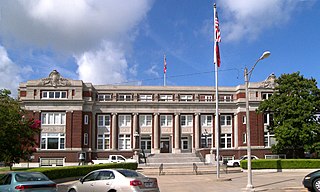
Jack County is a county located in the north central part of the U.S. state of Texas. As of the 2020 census, its population was 8,472. Its county seat is Jacksboro. The county was created in 1856 and organized the next year. It is named for Patrick Churchill Jack and his brother William Houston Jack, both soldiers of the Texas Revolution.

<span class="mw-page-title-main">Hutchinson County, Texas</span> County in Texas, United States

Hutchinson County is a county in the U.S. state of Texas. As of the 2020 census, its population was 20,617. Its county seat is Stinnett. The county was created in 1876, but not organized until 1901. It is named for Andrew Hutchinson, an early Texas attorney.

<span class="mw-page-title-main">Hansford County, Texas</span> County in Texas, United States

Hansford County is a county located in the U.S. state of Texas. As of the 2020 census, its population was 5,285. Its county seat is Spearman. The county was created in 1876 and organized in 1889. It is named for John M. Hansford, a Texas state congressman and judge.

<span class="mw-page-title-main">Garza County, Texas</span> County in Texas, United States

Garza County is a county located in the U.S. state of Texas. As of the 2020 census, its population was 5,816, of which most of the population were residing in its county seat, and only incorporated municipality, Post. The county was created in 1876 and later organized in 1907. Garza is named for a pioneer Bexar County family, as it was once a part of that county.

<span class="mw-page-title-main">Cherokee County, Texas</span> County in Texas, United States

Cherokee County is a county located in the U.S. state of Texas. As of the 2020 census, its population was 50,412. The county seat is Rusk, which lies 130 miles southeast of Dallas and 160 miles north of Houston. The county was named for the Cherokee, who lived in the area before being expelled in 1839. Cherokee County comprises the Jacksonville micropolitan statistical area, which is also included in the Tyler–Jacksonville combined statistical area.

<span class="mw-page-title-main">Anderson County, Texas</span> County in Texas, United States

Anderson County is a county in the U.S. state of Texas. Located within East Texas, its county seat is Palestine. As of the 2020 United States census, the population of Anderson County was 57,922. Anderson County comprises the Palestine micropolitan statistical area. Anderson County was organized in 1846, and was named after Kenneth Lewis Anderson (1805-1845), the last vice president of the Republic of Texas.

<span class="mw-page-title-main">Jacksboro, Texas</span> Town in Texas, United States

Jacksboro is a city in Jack County, Texas, in the United States. Its population was 4,184 at the 2020 census. U.S. Highways 281 and 380, and Texas State Highways 114 and 199 intersect at Jacksboro, which is the county seat of Jack County.

<span class="mw-page-title-main">Satanta</span> Native American tribe member and Kiowa war chief

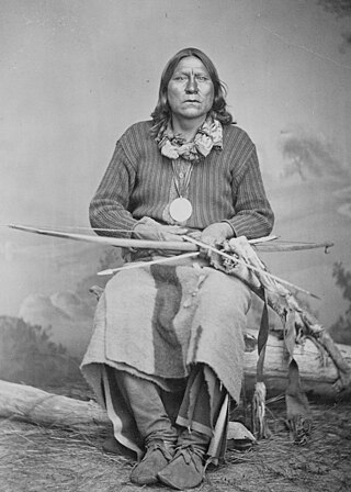
Satanta was a Kiowa war chief. He was a member of the Kiowa tribe, born around 1815, during the height of the power of the Plains Tribes, probably along the Canadian River in the traditional winter camp grounds of his people.

<span class="mw-page-title-main">Kicking Bird</span> Kiowa chief

Kicking Bird, also known as Tene-angop'te, "The Kicking Bird", "Eagle Who Strikes with his Talons", or "Striking Eagle" was a High Chief of the Kiowa in the 1870s. It is said that he was given his name for the way he fought his enemies. He was a Kiowa, though his grandfather had been a Crow captive who was adopted by the Kiowa. His mysterious death at Fort Sill on May 3, 1875, is the subject of much debate and speculation.

<span class="mw-page-title-main">Sitting Bear</span> Kiowa warrior

Satank was a prestigious Kiowa warrior and medicine man. He was born about 1800, probably in Kansas, and killed June 8, 1871. An able warrior, he became part of the Koitsenko, the society of the bravest Kiowa warriors. He led many raids against the Cheyennes, the Sacs, and the Foxes. As the white settlers' importance increased, he raided settlements, wagon trains, and even army outposts.

The Warren Wagon Train raid, also known as the Salt Creek massacre, occurred on May 18, 1871. Henry Warren was contracted to haul supplies to forts in the west of Texas, including Fort Richardson, Fort Griffin, and Fort Concho. Traveling down the Jacksboro-Belknap road heading towards Salt Creek Crossing, they encountered William Tecumseh Sherman. Less than an hour after encountering the famous General, they spotted a rather large group of riders ahead. They quickly realized that these were Native American warriors, probably Kiowa and/or Comanche.

<span class="mw-page-title-main">Fort Richardson (Texas)</span> State park and historic site in Texas, United States

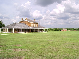
Fort Richardson was a United States Army installation located in present-day Jacksboro, Texas. Named in honor of Union General Israel B. Richardson, who died in the Battle of Antietam during the American Civil War, it was active from 1867 to 1878. Today, the site, with a few surviving buildings, is called Fort Richardson State Park, Historic Site and Lost Creek Reservoir State Trailway. It was designated a National Historic Landmark in 1963 for its role in securing the state's northern frontier in the post-Civil War era.

The Texas–Indian wars were a series of conflicts between settlers in Texas and the Southern Plains Indians during the 19th-century. Conflict between the Plains Indians and the Spanish began before other European and Anglo-American settlers were encouraged—first by Spain and then by the newly Independent Mexican government—to colonize Texas in order to provide a protective-settlement buffer in Texas between the Plains Indians and the rest of Mexico. As a consequence, conflict between Anglo-American settlers and Plains Indians occurred during the Texas colonial period as part of Mexico. The conflicts continued after Texas secured its independence from Mexico in 1836 and did not end until 30 years after Texas became a state of the United States, when in 1875 the last free band of Plains Indians, the Comanches led by Quahadi warrior Quanah Parker, surrendered and moved to the Fort Sill reservation in Oklahoma.

<span class="mw-page-title-main">Trial of Satanta and Big Tree</span> 1871 trial of Native American War Chiefs

The trial of Satanta and Big Tree occurred in May 1871 in the town of Jacksboro in Jack County, Texas, United States. This historic trial of Native American war chiefs of the Kiowa Indians Satanta and Big Tree for the murder of seven teamsters during a raid on Salt Creek Prairie near Jacksboro, Texas, marked the first time the United States had tried Native American chiefs in a state court. The trial attracted national and international attention. The two Kiowa leaders, with Satank, a legendary third War Chief, were formally indicted on July 1, 1871, and tried shortly thereafter, for acts arising out of the Warren Wagon Train Raid.

<span class="mw-page-title-main">White Horse (Kiowa leader)</span> Native American Kiowa warrior (1847–1892)

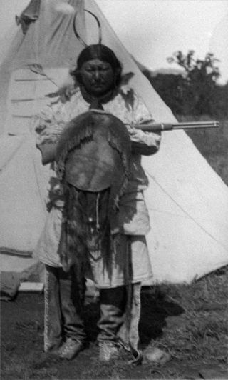
White Horse was a chief of the Kiowa. White Horse attended the council between southern plains tribes and the United States at Medicine Lodge in southern Kansas which resulted in the Medicine Lodge Treaty. Despite his attendance at the treaty signing he conducted frequent raids upon other tribes and white settlers. Follower of such elders as Guipago, Satanta and old Satank, he was often associated with Big Tree.

<span class="mw-page-title-main">Big Bow (Kiowa leader)</span>

Big Bow was a Kiowa war leader during the 19th century, an associate of Guipago and Satanta.

<span class="mw-page-title-main">Big Tree (Kiowa leader)</span>

Big Tree, Kiowa: Ado-ete, was a noted Kiowa warrior and chief. He was a loyal follower of the fighting chiefs party, and conducted frequent raids upon other tribes and white settlers, often being associated with Tsen-tainte.

References

  1. "Young County, Texas". United States Census Bureau . Retrieved January 30, 2022.
  2. "Find a County". National Association of Counties. Archived from the original on May 31, 2011. Retrieved June 7, 2011.
  3. "Texas: Individual County Chronologies". Texas Atlas of Historical County Boundaries. The Newberry Library. 2008. Retrieved May 27, 2015.
  4. "Young, William Cocke". The Handbook of Texas Online. The Texas State Historical Association. Retrieved May 27, 2009.
  5. Crouch, Carrie J: Brazos Indian Reservation from the Handbook of Texas Online. Retrieved May 5, 2010. Texas State Historical Association.
  6. Minor, David: White Man from the Handbook of Texas Online. Retrieved May 5, 2010. Texas State Historical Association.
  7. "Choctaw Tom". Fort Tours. Retrieved May 5, 2010.
  8. "Texas Governor Harden Richard Runnels". State of Texas. Retrieved May 5, 2010. Texas State Library and Archives Commission
  9. Baker, Erma: John Henry Brown from the Handbook of Texas Online. Retrieved May 5, 2010. Texas State Historical Association.
  10. Thompson, Jerry: John Robert Baylor from the Handbook of Texas Online. Retrieved May 5, 2010. Texas State Historical Association.
  11. Hosmer, Brian C: Satank from the Handbook of Texas Online. Retrieved May 5, 2010. Texas State Historical Association.
  12. Hosmer, Brian C: Satanta from the Handbook of Texas Online. Retrieved May 5, 2010. Texas State Historical Association.
  13. Hosmer, Brian C: Addo-etta Big Tree from the Handbook of Texas Online. Retrieved May 5, 2010. Texas State Historical Association.
  14. Anderson, H. Allen: Maman-ti from the Handbook of Texas Online. Retrieved May 5, 2010. Texas State Historical Association.
  15. Hamilton, Allen Lee: Warren Wagon Train Raid from the Handbook of Texas Online. Retrieved May 5, 2010. Texas State Historical Association.
  16. Weddle, Robert S: Ortiz Parrilla, Diego, Red River Campaign from the Handbook of Texas Online. Retrieved May 5, 2010. Texas State Historical Association.
  17. "Young County Timeline". Peters Colony Historical Society of Dallas County, Texas. Retrieved May 5, 2010.
  18. Neighbours, Kenneth F: Fort Belknap from the Handbook of Texas Online. Retrieved May 5, 2010. Texas State Historical Association.
  19. "Young County Timeline". Young County TxGenWeb. Retrieved May 5, 2010.
  20. "Graham, Texas". Texas Escapes – Blueprints For Travel, LLC. Retrieved May 5, 2010. Texas Escapes – Blueprints For Travel, LLC.
  21. "CPI, Pac Railroad". American Rails. Retrieved May 5, 2010. American Rails
  22. Anderson, H Allen: Wichita Falls and Southern Railroad from the Handbook of Texas Online. Retrieved May 5, 2010. Texas State Historical Association.
  23. Leffler, John: Young County from the Handbook of Texas Online. Retrieved May 5, 2010. Texas State Historical Association.
  24. "2010 Census Gazetteer Files". United States Census Bureau. August 22, 2012. Retrieved May 12, 2015.
  25. "Decennial Census of Population and Housing by Decades". US Census Bureau.
  26. "Texas Almanac: Population History of Counties from 1850–2010" (PDF). Texas Almanac. Archived (PDF) from the original on October 9, 2022. Retrieved May 12, 2015.
  27. 1 2 "P2 HISPANIC OR LATINO, AND NOT HISPANIC OR LATINO BY RACE - 2010: DEC Redistricting Data (PL 94-171) - Young County, Texas". United States Census Bureau .
  28. 1 2 "P2 HISPANIC OR LATINO, AND NOT HISPANIC OR LATINO BY RACE - 2020: DEC Redistricting Data (PL 94-171) - Young County, Texas". United States Census Bureau .
  29. "U.S. Census website". United States Census Bureau . Retrieved May 14, 2011.
  30. Leonhardt, David; Quealy, Kevin (June 26, 2015), "Where Same-Sex Couples Live", The New York Times, retrieved July 6, 2015
  31. "State Rep. Springer announces district tour July 30". Lubbock Avalanche-Journal, July 16, 2013. Retrieved July 18, 2013.
  32. Leip, David. "Dave Leip's Atlas of U.S. Presidential Elections". uselectionatlas.org. Retrieved April 11, 2018.
  33. "2020 CENSUS - SCHOOL DISTRICT REFERENCE MAP: Young County, TX" (PDF). U.S. Census Bureau. Archived (PDF) from the original on October 9, 2022. Retrieved June 29, 2022. - Text list
  34. Texas Education Agency: See map of Young County. Retrieved on April 9, 2020.
  35. "Mergargel School Closes Its Doors". KAUZ-TV. Archived from the original on September 28, 2007. Retrieved July 17, 2010.
  36. Texas Education Code, Sec. 130.190. NORTH CENTRAL TEXAS COLLEGE DISTRICT SERVICE AREA. Sec. 130.196. RANGER JUNIOR COLLEGE DISTRICT SERVICE AREA..

33°11′N98°42′W / 33.18°N 98.70°W / 33.18; -98.70