Jacksboro, Texas

Last updated

Jacksboro, Texas
Mesquiteville
Jacksboro4 (1 of 1).jpg
Businesses in downtown Jacksboro
TXMap-doton-Jacksboro.PNG
Location of Jacksboro, Texas
Jack County Jacksboro.svg
Coordinates: 33°13′24″N98°9′39″W / 33.22333°N 98.16083°W / 33.22333; -98.16083
Country United States
State Texas
County Jack
Area
[1]
  Total8.09 sq mi (20.95 km2)
  Land7.23 sq mi (18.72 km2)
  Water0.86 sq mi (2.23 km2)
Elevation
[2]
1,083 ft (330 m)
Population
 (2020) [3]
  Total4,184
  Density578.94/sq mi (223.53/km2)
Time zone UTC-6 (Central (CST))
  Summer (DST) UTC-5 (CDT)
ZIP code
76458
Area code 940
FIPS code 48-37168 [4]
GNIS feature ID1338568 [2]
Website www.cityofjacksboro.com

Jacksboro is a city in Jack County, Texas, in the United States. Its population was 4,184 at the 2020 census. [3] U.S. Highways 281 and 380, and Texas State Highways 114 and 199 intersect at Jacksboro, which is the county seat of Jack County. [5]

Contents

History

Jacksboro was first settled in the 1850s, with newcomers attracted by land offers from the Texas Emigration and Land Office. Originally called "Mesquiteville", the community grew up along the banks of Lost Creek and spread out over the pastureland between Lost Creek and the waters of the West Fork of Keechi Creek. It was renamed "Jacksboro" in 1858, when it became the county seat, in honor of brothers William and Patrick Jack, veterans of the Texas Revolution. [6] [7] [8] Regular postal service began in 1859. Jacksboro was located on one route of the Butterfield Overland Mail.

The county was one of the few in Texas to vote against secession before the Civil War. [9] It continued to suffer from Native American raids until Fort Richardson was built and garrisoned in 1870 south of Jacksboro. The town gained national attention in 1871 when two Kiowa chiefs, Satanta and Big Tree, were tried for murder there.

The arrival of the Chicago, Rock Island & Texas Railroad in 1898 increased the town's commercial importance to the surrounding region, enhancing it as a center of trade. The completion of highways and other roads later on also connected the town to other markets.

Fort Richardson State Historical Park is in the southern part of the city. Jacksboro claims to have the first state 4-H club, formed in the 1910s.

On March 21, 2022, an EF3 tornado struck the town causing damage to around 80 homes [10] and heavily damaging the high school. Nine people were injured. [11] [12]

Geography

Jacksboro is located in central Jack County at 33°13′24″N98°09′39″W / 33.223355°N 98.160845°W / 33.223355; -98.160845 (33.223355, –98.160845). [13] U.S. Route 281 runs through the city center, leading south 31 miles (50 km) to Mineral Wells and northwest 58 miles (93 km) to Wichita Falls. U.S. Route 380 joins US 281 in the center of Jacksboro, but heads west out of town on Belknap Street, leading 27 miles (43 km) to Graham. US 380 leaves Jacksboro to the southeast with US 281, but then leads east 37 miles (60 km) to Decatur. Fort Worth is 60 miles (97 km) southeast of Jacksboro via US 281 and Texas State Highway 199.

According to the United States Census Bureau, Jacksboro has a total area of 8.1 square miles (20.9 km2), of which 0.86 square miles (2.2 km2) is covered by water. [1] The water area comprises Lake Jacksboro, a reservoir on Lost Creek in the northeast part of the city. Jacksboro is part of the watershed of the West Fork of the Trinity River.

Climate

The climate in this area is characterized by hot, humid summers and generally mild to cool winters. According to the Köppen climate classification, Jacksboro has a humid subtropical climate, Cfa on climate maps. [14]

Climate data for Jacksboro, Texas (1991–2020 normals, extremes 1941–present)
MonthJanFebMarAprMayJunJulAugSepOctNovDecYear
Record high °F (°C)92
(33)
94
(34)
99
(37)
100
(38)
104
(40)
113
(45)
113
(45)
113
(45)
111
(44)
103
(39)
92
(33)
87
(31)
113
(45)
Mean daily maximum °F (°C)55.4
(13.0)
59.4
(15.2)
67.8
(19.9)
75.8
(24.3)
83.2
(28.4)
91.0
(32.8)
95.7
(35.4)
95.8
(35.4)
87.9
(31.1)
77.6
(25.3)
65.7
(18.7)
56.8
(13.8)
76.0
(24.4)
Daily mean °F (°C)42.5
(5.8)
46.6
(8.1)
54.8
(12.7)
62.7
(17.1)
71.4
(21.9)
79.3
(26.3)
83.6
(28.7)
83.3
(28.5)
75.4
(24.1)
64.5
(18.1)
53.1
(11.7)
44.5
(6.9)
63.5
(17.5)
Mean daily minimum °F (°C)29.5
(−1.4)
33.9
(1.1)
41.9
(5.5)
49.7
(9.8)
59.6
(15.3)
67.7
(19.8)
71.5
(21.9)
70.8
(21.6)
63.0
(17.2)
51.4
(10.8)
40.4
(4.7)
32.1
(0.1)
51.0
(10.6)
Record low °F (°C)−3
(−19)
−11
(−24)
5
(−15)
27
(−3)
33
(1)
49
(9)
56
(13)
54
(12)
33
(1)
22
(−6)
15
(−9)
−8
(−22)
−11
(−24)
Average precipitation inches (mm)1.49
(38)
2.26
(57)
2.95
(75)
2.84
(72)
4.29
(109)
4.01
(102)
1.85
(47)
2.18
(55)
3.14
(80)
3.85
(98)
1.86
(47)
1.94
(49)
32.66
(830)
Average precipitation days (≥ 0.01 in)5.05.46.95.38.37.04.25.06.36.65.25.470.6
Source: NOAA [15] [16]

Demographics

Historical population
CensusPop.Note
1880 387
1890 75194.1%
1900 1,31174.6%
1910 1,48012.9%
1920 1,373−7.2%
1930 1,83733.8%
1940 2,36828.9%
1950 2,95124.6%
1960 3,81629.3%
1970 3,554−6.9%
1980 4,00012.5%
1990 3,350−16.2%
2000 4,53335.3%
2010 4,511−0.5%
2020 4,184−7.2%
U.S. Decennial Census [17]

2020 census

Jacksboro racial composition [18]
(NH = Non-Hispanic) [lower-alpha 1]
RaceNumberPercentage
White (NH)2,60962.36%
Black or African American (NH)2937.0%
Native American or Alaska Native (NH)90.22%
Asian (NH)330.79%
Pacific Islander (NH)20.05%
Some Other Race (NH)50.12%
Mixed/Multi-Racial (NH)922.2%
Hispanic or Latino 1,14127.27%
Total4,184

As of the 2020 United States census, there were 4,184 people, 1,468 households, and 861 families residing in the city.

2000 census

At the census [4] of 2000, 4,533 people, 1,382 households, and 954 families resided in the city. The population density was 778.7 inhabitants per square mile (300.7/km2). The 1,559 housing units average 267.8/sq mi (103.4/km2). The racial makeup of the city was 81.95% White, 10.46% African American, 0.57% Native American, 0.31% Asian, 0.02% Pacific Islander, 5.56% from other races, and 1.13% from two or more races. Hispanics or Latinos of any race were 10.74% of the population.

Of the 1,382 households, 33.7% had children under the age of 18 living with them, 53.7% were married couples living together, 11.7% had a female householder with no husband present, and 30.9% were not families. About 28.4% of households were one person and 16.3% were one person aged 65 or older. The average household size was 2.50, and the average family size was 3.06. The age distribution was 21.7% under 18, 13.0% from 18 to 24, 33.1% from 25 to 44, 17.9% from 45 to 64, and 14.3% were 65 or older. The median age was 35 years. For every 100 females, there were 139.0 males. For every 100 females age 18 and over, there were 156.5 males.

The median household income was $30,833, and the median family income was $36,759. Males had a median income of $26,716 versus $20,592 for females. The per capita income for the city was $13,595. About 12.2% of families and 15.0% of the population were below the poverty line, including 16.0% of those under age 18 and 14.4% of those age 65 or over.

Education

The city is served by the Jacksboro Independent School District.

Notable people

Related Research Articles

<span class="mw-page-title-main">Jack County, Texas</span> County in Texas, United States

Jack County is a county located in the north central part of the U.S. state of Texas. As of the 2020 census, its population was 8,472. Its county seat is Jacksboro. The county was created in 1856 and organized the next year. It is named for Patrick Churchill Jack and his brother William Houston Jack, both soldiers of the Texas Revolution.

<span class="mw-page-title-main">Eureka, Kansas</span> City in Greenwood County, Kansas

Eureka is a city in and the county seat of Greenwood County, Kansas, United States. As of the 2020 census, the population of the city was 2,332.

<span class="mw-page-title-main">Reading, Kansas</span> City in Lyon County, Kansas

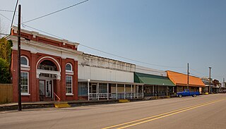
Reading is a city in Lyon County, Kansas, United States. As of the 2020 census, the population of the city was 181.

<span class="mw-page-title-main">De Kalb, Texas</span> City in Texas, United States

De Kalb is a city in Bowie County, Texas, United States; it is part of the Texarkana metropolitan statistical area. Its two area codes are 430 and 903. Its ZIP code is 75559. It is in the Central Time Zone, and its population was 1,527 at the 2020 United States census.

<span class="mw-page-title-main">Paducah, Texas</span> Town in Texas, United States

Paducah is a town in Cottle County, Texas, United States. The population was 1,186 at the 2010 census, down from 1,498 in 2000. It is the county seat of Cottle County. It is just south of the Texas Panhandle and east of the Llano Estacado.

<span class="mw-page-title-main">Clarendon, Texas</span> City in Texas, United States

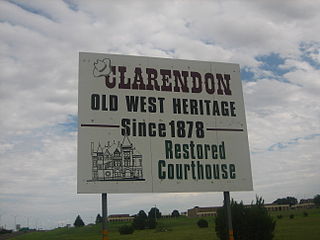
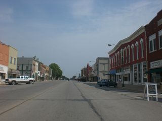
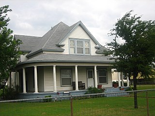
Clarendon is a city in Donley County, Texas, United States. Its population was 2,026 at the 2010 census. The county seat of Donley County, Clarendon is located on U.S. Highway 287 in the Texas Panhandle, 60 miles (97 km) east of Amarillo.

<span class="mw-page-title-main">Hale Center, Texas</span> City in Texas, United States

Hale Center is a city in Hale County, Texas. The population was 2,062 at the 2020 census, down from 2,252 in 2010.

<span class="mw-page-title-main">Hamilton, Texas</span> City in Texas, United States

Hamilton is a city in and the county seat of Hamilton County, Texas, United States, located in the state's central region. Its population was 2,895 at the 2020 census.

<span class="mw-page-title-main">Gruver, Texas</span> City in Texas, United States

Gruver is a city in Hansford County, Texas, United States. The population was 1,130 at the 2020 census. Farwell, in the center of Hansford County, approximately three miles east of what became Gruver, was established in 1880 by the Canott family of Illinois, and was the first town in the county. Gruver was established shortly after, and Farwell rapidly fell into oblivion after 1889, when it lost a county seat election to Hansford.

<span class="mw-page-title-main">Athens, Texas</span> City in Texas, United States

Athens is a city and the county seat of Henderson County, Texas, in the United States. As of the 2020 census, the city population was 12,857. The city has called itself the "Black-Eyed Pea Capital of the World." Athens was selected as one of the first "Certified Retirement Communities" in Texas. Athens was incorporated in 1856 and was named after Athens, the capital of Greece.

<span class="mw-page-title-main">Granbury, Texas</span> City in Texas, United States

Granbury is a city in and the county seat of Hood County, Texas, United States. As of the 2020 census, the city's population was 10,958, and it is the principal city of the Granbury micropolitan statistical area. Granbury is named after Confederate General Hiram B. Granbury.

<span class="mw-page-title-main">Bryson, Texas</span> City in Texas, United States

Bryson is a city in Jack County, Texas, United States. As of the 2010 census, its population was 539.

<span class="mw-page-title-main">Hawley, Texas</span> City in Texas, United States

Hawley is a city in Jones County, Texas, United States. The population was 634 at the 2010 census.

<span class="mw-page-title-main">Bowie, Texas</span> City in Montague County, Texas, US

Bowie is a town in Montague County, Texas, United States. The population was 5,218 at the 2010 census.

<span class="mw-page-title-main">Cactus, Texas</span> City in Texas, United States

Cactus is a city in Moore County, Texas, United States, located along U.S. Route 287. The population was 3,179 at the 2010 census.

<span class="mw-page-title-main">Perryton, Texas</span> City in Texas, United States

Perryton is a city in and the county seat of Ochiltree County, Texas, United States. As of the 2020 census, the population of the city was 8,492. It is located a few miles south of the Texas / Oklahoma state line.

<span class="mw-page-title-main">Onalaska, Texas</span> City in the United States

Onalaska is a city in Polk County, Texas, United States. Situated on a peninsula between the main channel and one arm of Lake Livingston, the population was 3,020 at the 2020 census.

<span class="mw-page-title-main">Scotland, Texas</span> City in Texas, United States

Scotland is a city in Archer County in the U.S. state of Texas. It is part of the Wichita Falls, Texas Metropolitan Statistical Area. The population was 501 at the 2010 census. The town is named for its founder, Henry J. Scott.

<span class="mw-page-title-main">Valley Mills, Texas</span> City in Texas, United States

Valley Mills is a city in Bosque and McLennan counties in central Texas, United States. The population was 1,203 at the 2010 census.

<span class="mw-page-title-main">Deport, Texas</span> City in Texas, United States

Deport is a city in Lamar and Red River counties in the U.S. state of Texas. The population was 550 at the 2020 census.

References

  1. 1 2 "2020 U.S. Gazetteer Files". United States Census Bureau. Retrieved February 7, 2024.
  2. 1 2 U.S. Geological Survey Geographic Names Information System: Jacksboro, Texas
  3. 1 2 "Profile of General Population and Housing Characteristics: 2020 Demographic Profile Data (DP-1): Jacksboro city, Texas". United States Census Bureau . Retrieved February 7, 2024.
  4. 1 2 "U.S. Census website". United States Census Bureau . Retrieved January 31, 2008.
  5. National Association of Counties. "NACo County Explorer" . Retrieved February 7, 2024.
  6. "Jack, Patrick Churchill". The Handbook of Texas Online. The Texas State Historical Association. Retrieved May 27, 2009.
  7. "Jack, William Houston". The Handbook of Texas Online. The Texas State Historical Association. Retrieved May 27, 2009.
  8. Gannett, Henry (1905). The Origin of Certain Place Names in the United States. Govt. Print. Off. pp.  167.
  9. Joe T. Timmons (1973). "The Referendum in Texas on the Ordinance of Secession, February 23, 1861: The Vote". East Texas Historical Journal. 11 (2). Retrieved September 16, 2017.
  10. "Texas tornado outbreak: Jacksboro residents dig out of debris and damaged homes". KERA News. March 22, 2022. Retrieved November 4, 2022.
  11. "NWS Damage Survey for 3/21/22 Tornado Event - Update #3". Iowa Environmental Mesonet. National Weather Service in Fort Worth, Texas. March 25, 2022. Retrieved March 25, 2022.
  12. "North Texas storm damage: What we're seeing in Jack County after reported tornado". WFAA. March 21, 2022. Retrieved March 22, 2022.
  13. "US Gazetteer files: 2010, 2000, and 1990". United States Census Bureau. February 12, 2011. Retrieved April 23, 2011.
  14. Climate Summary for Jacksboro, Texas
  15. "NOWData - NOAA Online Weather Data". National Oceanic and Atmospheric Administration. Retrieved November 9, 2023.
  16. "Summary of Monthly Normals 1991-2020". National Oceanic and Atmospheric Administration. Retrieved November 9, 2023.
  17. "Census of Population and Housing". Census.gov. Retrieved June 4, 2015.
  18. "Explore Census Data". data.census.gov. Retrieved May 21, 2022.
  19. "About the Hispanic Population and its Origin". www.census.gov. Retrieved May 18, 2022.
  1. Note: the US Census treats Hispanic/Latino as an ethnic category. This table excludes Latinos from the racial categories and assigns them to a separate category. Hispanics/Latinos can be of any race. [19]