Brownfield, Texas

Last updated

Brownfield, Texas
Brownfield Texas City Hall 2019.jpg
Brownfield City Hall
TXMap-doton-Brownfield.PNG
Location of Brownfield, Texas
Terry County Brownfield.svg
Coordinates: 33°10′47″N102°16′15″W / 33.17972°N 102.27083°W / 33.17972; -102.27083
CountryUnited States
State Texas
County Terry
Area
[1]
  Total6.55 sq mi (16.97 km2)
  Land6.51 sq mi (16.87 km2)
  Water0.04 sq mi (0.10 km2)
Elevation
3,310 ft (1,009 m)
Population
 (2020) [2]
  Total8,936
  Density1,400/sq mi (530/km2)
Time zone UTC−6 (Central (CST))
  Summer (DST) UTC−5 (CDT)
ZIP Code
79316
Area code 806
FIPS code 48-10720 [3]
GNIS feature ID1352989 [4]
Website www.ci.brownfield.tx.us

Brownfield is a city in Terry County, Texas, United States. Its population was 8,936 at the 2020 census. [2] Brownfield is 39 miles southwest of Lubbock, it is the county seat of Terry County. [5]

Contents

History

In 1903, town promoters W. G. Hardin and A. F. Small purchased the county's central lot, platted the site, and named the town after the Brownfield ranching family. To boost chances of becoming the county seat, they granted a lot to every county voter. [6]

The town's early years saw the construction of essential structures, including the courthouse, school, and churches. Hill's Hotel became the first business, housing the inaugural post office. On June 28, 1904, Brownfield secured the county seat designation, narrowly defeating Gomez in an election. The Brownfield State Bank opened in 1905, serving multiple counties and parts of eastern New Mexico. [6]

Brownfield was incorporated in 1920. Oil wells became operational in 1941, diversifying the town's economic landscape. [6]

Geography

According to the United States Census Bureau, Brownfield has an area of 6.3 sq mi (16 km2), 0.32% of which is covered by water.

Brownfield lies in the center of Terry County, in the southern portion of the South Plains and Llano Estacado. The city rests on a windblown deposit called the Blackwater Draw Formation, which is underlain by a thick layer of caliche, referred to locally as the "caprock". Beneath the caliche layer lies fluvial deposits called the Ogallala Formation, which contains a portion of the Ogallala Aquifer. The Caprock Escarpment, about 50 miles east, forms a precipitous drop of about 1,000 feet (305 m) and exposes various geologic layers. In early days, climbing the Caprock Escarpment was not easy for horse-drawn covered wagons.

The only terrain variation lies at the south end of the city, where Lost Draw carves a channel that runs across the entire county. Lost Draw formed over 10,000 years ago at the end of the last ice age, when the climate of the area was much wetter. When the vast glaciers of the north retreated, they left numerous dry river channels crisscrossing the Llano Estacado. When settlers during the 1800s ventured across this area, they often went into these channels expecting to find water, but unless significant rains had occurred recently, their search was in vain, with many of the parties becoming "lost", hence the name, Lost Draw.

The most notable geographic feature of Brownfield is its red soil. The soil creates an almost iridescent red color during sunrise and sunset due to the high iron oxide content.

Climate

Brownfield lies in a semiarid temperate zone, where high winds and extreme temperature variations are the norm. The summers reach over 100 °F (37.8 °C) for multiple consecutive days. The winters often fall below freezing for extended periods, but snow remains unusual due to very little precipitation forming in the winter.

The most significant time of the year for weather events starts in March and runs through September, when severe thunderstorms form on the Great Plains. Rain, winds, hail, and a few tornadoes are to be expected at this time of year. Late thunderstorms that produce hail are significantly harmful to the local economy, as it destroys the local cotton crop.

Climate data for Brownfield, Texas (1991–2020 normals, extremes 1953–present)
MonthJanFebMarAprMayJunJulAugSepOctNovDecYear
Record high °F (°C)84
(29)
87
(31)
97
(36)
102
(39)
110
(43)
111
(44)
109
(43)
109
(43)
104
(40)
101
(38)
88
(31)
82
(28)
111
(44)
Mean maximum °F (°C)75.0
(23.9)
79.9
(26.6)
86.8
(30.4)
91.9
(33.3)
98.8
(37.1)
103.0
(39.4)
101.8
(38.8)
100.5
(38.1)
97.4
(36.3)
92.1
(33.4)
82.7
(28.2)
75.1
(23.9)
105.0
(40.6)
Mean daily maximum °F (°C)55.1
(12.8)
59.9
(15.5)
68.2
(20.1)
76.6
(24.8)
84.5
(29.2)
92.2
(33.4)
93.6
(34.2)
92.5
(33.6)
85.2
(29.6)
76.4
(24.7)
64.3
(17.9)
55.8
(13.2)
75.4
(24.1)
Daily mean °F (°C)40.9
(4.9)
44.8
(7.1)
52.7
(11.5)
60.6
(15.9)
70.0
(21.1)
78.3
(25.7)
80.6
(27.0)
79.3
(26.3)
72.0
(22.2)
61.8
(16.6)
49.9
(9.9)
41.9
(5.5)
61.1
(16.2)
Mean daily minimum °F (°C)26.7
(−2.9)
29.7
(−1.3)
37.2
(2.9)
44.6
(7.0)
55.5
(13.1)
64.5
(18.1)
67.5
(19.7)
66.1
(18.9)
58.7
(14.8)
47.3
(8.5)
35.6
(2.0)
28.0
(−2.2)
46.8
(8.2)
Mean minimum °F (°C)14.7
(−9.6)
17.1
(−8.3)
22.0
(−5.6)
31.1
(−0.5)
41.6
(5.3)
56.0
(13.3)
61.7
(16.5)
60.0
(15.6)
47.0
(8.3)
32.0
(0.0)
21.1
(−6.1)
14.9
(−9.5)
10.7
(−11.8)
Record low °F (°C)−8
(−22)
−1
(−18)
8
(−13)
22
(−6)
27
(−3)
45
(7)
53
(12)
52
(11)
36
(2)
15
(−9)
4
(−16)
−1
(−18)
−8
(−22)
Average precipitation inches (mm)0.69
(18)
0.62
(16)
1.07
(27)
1.31
(33)
2.20
(56)
2.67
(68)
1.94
(49)
1.80
(46)
2.56
(65)
1.57
(40)
0.88
(22)
0.74
(19)
18.05
(458)
Average snowfall inches (cm)1.4
(3.6)
1.2
(3.0)
0.3
(0.76)
0.0
(0.0)
0.0
(0.0)
0.0
(0.0)
0.0
(0.0)
0.0
(0.0)
0.0
(0.0)
0.1
(0.25)
0.8
(2.0)
1.2
(3.0)
5.0
(13)
Average precipitation days (≥ 0.01 in)3.43.33.83.55.76.55.25.76.25.23.73.355.5
Average snowy days (≥ 0.1 in)1.01.00.20.10.00.00.00.00.00.10.50.83.7
Source: NOAA [7] [8]

Economy

Cotton farming is the backbone of not only Brownfield, but also the entire South Plains in general. Cotton fields stretch for miles, and the harvest season in October sees frenzied activity as harvesters (locally called cotton strippers), module makers, and module trucks are seen all over the county.

A haze also develops over the city as the local cotton gins go to work stripping the cotton from the burr, separating the seeds, and then compressing the cotton into 500-lb bales. The haze is actually fine cotton dust, and sometimes small drifts develop in the street resembling snow mixed with red soil.

Peanut growing has found a toehold on the economy, as have vineyards. In recent years, grape growing has made Terry County a producer of wine grapes used as filler for inexpensive wines. [9] Several wineries are now established in the county, which produce average-to-poor quality wine according to numerous reviews and wine review aggregator websites. [10] [11] Local farmers, ranchers, and landowners began growing grapes here as early as 1950, with a few new wineries near the city due to the repeal of fully dry county status in 2008. [12] Several older and more notable wineries are in the Lubbock area, about 30 miles northeast.

Oil production continues to drop from its previous levels in the 1980s. According to current trends, Terry County and Brownfield will continue to decline significantly in oil production and importance in West Texas. [13] [14]

Wal-Mart chose to not renew their lease on their facility on the eastern edge of town, saying the town was not sufficiently economically viable for them to continue to operate. [15]

Demographics

Historical population
CensusPop.Note
1930 1,907
1940 4,009110.2%
1950 6,16153.7%
1960 10,28667.0%
1970 9,647−6.2%
1980 10,3877.7%
1990 9,560−8.0%
2000 9,488−0.8%
2010 9,6571.8%
2020 8,936−7.5%
U.S. Decennial Census [16] [ failed verification ] 2020 [2]

Brownfield and Terry County have one of the highest rates of teen pregnancy in Texas. The teen pregnancy rate is 98.1 out of 1000, more than double the national average. [17]

Brownfield has an extremely high sexually transmitted infection rate of gonorrhea, chlamydia, and most notably syphilis, which is much higher than the state average (7.8 per 100,000). [18]

Only 61.5% of the population holds a high school degree or higher, 8.9% a bachelor's degree or higher, and 2.7% a master's degree or higher. About 6.1% of the population was unemployed in 2010.

2020 census

Brownfield racial composition [2]
(NH = Non-Hispanic) [lower-alpha 1]
RaceNumberPercentage
White (NH)2,93532.84%
Black or African American (NH)3834.29%
Native American or Alaska Native (NH)250.28%
Asian (NH)360.4%
Some Other Race (NH)230.26%
Mixed/Multi-Racial (NH)1371.53%
Hispanic or Latino 5,39760.4%
Total8,936

As of the 2020 United States census, there were 8,936 people, 3,271 households, and 2,086 families residing in the city.

2000 census

As of the census [3] of 2000, 9,488 people, 3,176 households, and 2,337 families resided in the city. The population density was 1,501.0 inhabitants per square mile (579.5/km2). The 3,735 housing units had an average density of 590.9 per square mile (228.1/km2). The racial makeup of the city was 24.56% White, 6.59% African American, 0.42% Native American, 0.25% Asian, 14.47% from other races, and 3.71% from two or more races. Hispanics of all origins contributed 45.95% of the population.

The city governance consists overwhelmingly of the White population, with only 23.4% of the council consisting of the minorities that are 75% of the population. The White representation is about 75% of the council, while only consisting of 24% of the population. [20]

Of the 3,176 households, 34.6% had children under the age of 18 living with them, 55.3% were married couples living together, 14.1% had a female householder with no husband present, and 26.4% were not families. About 24% of all households were made up of individuals, and 14.3% had someone living alone who was 65 years of age or older. The average household size was 2.68 and the average family size was 3.19.

In the city, the population was distributed as 27.2% under the age of 18, 9.8% from 18 to 24, 27.3% from 25 to 44, 20.0% from 45 to 64, and 15.8% who were 65 years of age or older. The median age was 35 years. For every 100 females, there were 109.5 males. For every 100 females age 18 and over, there were 111.6 males.

The median income for a household in the city was $26,504, and for a family was $32,076. Males had a median income of $23,637 versus $19,628 for females. The per capita income for the city was $13,854. About 21.8% of families and 26.0% of the population were below the poverty line, including 38.7% of those under age 18 and 13.5% of those age 65 or over.

Brownfield is served by a weekly newspaper, nearby stations KBXJ (FM) and KPET (AM), and the various Lubbock radio and TV stations. KKUB (AM) and KTTU-FM are licensed to Brownfield, but operate primarily from offices and studios in Lubbock.

Crime

As of 2019, violent and property crime rates were higher in Brownfield than the national average. [21]

Brownfield News publisher, former head of the Brownfield Industrial Development Corporation (BIDCorps), and 1997 Brownfield High School graduate, Brian Brisendine, was convicted of receipt and distribution of child pornography, and sentenced to 12 years in federal prison on September 8, 2022. Brisendine admitted to trading images of child sexual abuse online since 2014. He admitted to viewing between 5,000 and 10,000 videos and images of child sexual abuse with children as young as four months old. [22]

Terry County Courthouse was photographed for this postcard mailed in August 1910. Terry Co Courthouse - 1910.jpg
Terry County Courthouse was photographed for this postcard mailed in August 1910.

Education

Brownfield High School Brownfield Texas High School 2019.jpg
Brownfield High School

The City of Brownfield is served by the Brownfield Independent School District, ranked 899 out of 932 districts in Texas with a zero star rating. [23] Brownfield ISD is considered a historically low-performing school district with abnormally high teacher turnover according to the local newspaper. [23]

Brownfield High School was rated "academically unacceptable" by the Texas State Board of Education in 2011. [24]

For the 2012–2013 school year, Brownfield High School State of Texas Assessments of Academic Readiness test scores resulted in the following student passing scores: [25]

For the 2021–2022 school year, Brownfield High School was ranked among the bottom 15% of all high schools in Texas, with a ranking of 1414 out of 1861 high schools. [26]

Transportation

Brownfield, situated at the crossroads of U.S. highways 62, 82, 380, and 385, as well as Texas State Highway 137. [6]

Dry county status

Several town meetings were held in 2008 to discuss the issue of selling beer and wine in Terry County. [27] [28] On November 4, a majority of registered voters voted to legalize the sale of beer and wine in Terry County (1533 for, 1211 against). [29]

See also

Related Research Articles

<span class="mw-page-title-main">Yoakum County, Texas</span> County in Texas, United States

Yoakum County is a county located in the far western portion of the U.S. state of Texas. As of the 2020 census, the population was 7,694. Its county seat is Plains. The county was created in 1876 and later organized in 1907. It is named for Henderson King Yoakum, a Texas historian.

<span class="mw-page-title-main">Terry County, Texas</span> County in Texas, United States

Terry County is a county located in the U.S. state of Texas. As of the 2020 census, its population was 11,831. Its county seat is Brownfield. The county was demarked in 1876 and organized in 1904. It is named for Benjamin Franklin Terry, a colonel in the Confederate Army. Terry County was one of 46 dry counties in the state of Texas, but is now a moist county. Terry County is one of the most productive pumpkin producing counties in the United States.

<span class="mw-page-title-main">Lynn County, Texas</span> County in Texas, United States

Lynn County is a county in the U.S. state of Texas. As of the 2020 census, its population was 5,596. Its county seat is Tahoka. The county was created in 1876 and organized in 1903.

<span class="mw-page-title-main">Lubbock County, Texas</span> County in Texas, United States

Lubbock County is a county located in the U.S. state of Texas. The 2020 census placed the population at 310,639. Its county seat and largest city is Lubbock. The county was created in 1876 and organized in 1891. It is named for Thomas Saltus Lubbock, a Confederate colonel and Texas Ranger.

<span class="mw-page-title-main">Hockley County, Texas</span> County in Texas, United States

Hockley County is a county located in the U.S. state of Texas. As of the 2020 census, its population was 21,537. Its county seat is Levelland. The county was created in 1876, but not organized until 1921. It is named for George Washington Hockley, a secretary of war of the Republic of Texas.

<span class="mw-page-title-main">Garza County, Texas</span> County in Texas, United States

Garza County is a county located in the U.S. state of Texas. As of the 2020 census, its population was 5,816, of which most of the population were residing in its county seat, and only incorporated municipality, Post. The county was created in 1876 and later organized in 1907. Garza is named for a pioneer Bexar County family, as it was once a part of that county.

<span class="mw-page-title-main">Crosby County, Texas</span> County in Texas, United States

Crosby County is a county located in the U.S. state of Texas. As of the 2020 census, its population was 5,133. The county seat is Crosbyton. The county was founded in 1876 and later organized in 1886. Both the county and its seat are named for Stephen Crosby, a land commissioner in Texas.

<span class="mw-page-title-main">Ralls, Texas</span> City in Texas, United States

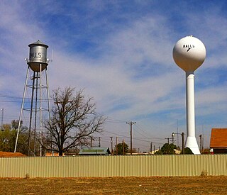
Ralls is a city in Crosby County, Texas, United States. It was named after John Robinson Ralls, who, with the help of W.E. McLaughlin, laid out the townsite in July 1911. As of the 2010 census, it had a population of 1,944, down from 2,252 at the 2000 census. Ralls is surrounded by productive farmlands that primarily produce cotton and grains, with lesser amounts of soybean, sunflower seed, and vegetables.

<span class="mw-page-title-main">Lamesa, Texas</span> City in Texas, United States

Lamesa is a city in and the county seat of Dawson County, Texas, United States. The population was 8,674 at the 2020 census, down from 9,952 at the 2000 census. Located south of Lubbock on the Llano Estacado, Lamesa was founded in 1903. Most of its economy is based on cotton farming. The Preston E. Smith prison unit, named for the former governor of Texas, is located just outside Lamesa.

<span class="mw-page-title-main">Floydada, Texas</span> City in Texas, United States

Floydada is a city in and the county seat of Floyd County, Texas, United States. This rural community lies on the high plains of the Llano Estacado in West Texas and is sometimes referred to as the Pumpkin Capital of Texas. The population was 3,038 at the 2010 census, down from 3,676 at the 2000 census.

<span class="mw-page-title-main">Post, Texas</span> City in Texas, United States of America

Post is a city in and the county seat of Garza County, Texas, United States. Its population was 5,376 at the 2010 census.

<span class="mw-page-title-main">Petersburg, Texas</span> City in Texas, United States

Petersburg is a city in Hale County, Texas, United States. As of the 2010 census, it had a population of 1,202.

<span class="mw-page-title-main">Memphis, Texas</span> City in Texas, United States

Memphis is a city and the county seat of Hall County, Texas, United States. As of the 2010 census, the population was 2,290.

<span class="mw-page-title-main">Levelland, Texas</span> City in Texas, United States

Levelland is a city in Hockley County, Texas, United States. As of the 2020 census, the city population was 12,652, down from 13,542 at the 2010 census. It is the county seat of Hockley County. It is located on the Llano Estacado, 30 miles (48 km) west of Lubbock. Major industries include cotton farming and petroleum production. It is the home of South Plains College. Levelland is the principal city of the Levelland micropolitan statistical area, which includes all of Hockley County and part of the larger Lubbock–Levelland combined statistical area. Levelland was so named on account of the flat land at the town site.

<span class="mw-page-title-main">Smyer, Texas</span> Town in Texas, United States

Smyer is a town in Hockley County, Texas, United States. The nickname it is known for is "The Pit Stop Town", since the town is between two major urban areas. The population was 474 at the 2010 census. in 2023, the population declined to 433.

<span class="mw-page-title-main">Littlefield, Texas</span> City in Texas, United States

Littlefield is a city in and the county seat of Lamb County, Texas, United States. Its population was 6,372 at the 2010 census. It is located in a significant cotton-growing region, northwest of Lubbock on the Llano Estacado just south of the Texas Panhandle. Littlefield had a large denim-manufacturing plant operated by American Cotton Growers.

<span class="mw-page-title-main">Lubbock, Texas</span> City in Texas

Lubbock is a city in the U.S. state of Texas and the seat of Lubbock County. With a population of 263,930 in 2022, the city is the 10th-most populous city in Texas and the 85th-most populous in the United States. The city is in the northwestern part of the state, an area known historically and geographically as the Llano Estacado, and ecologically is part of the southern end of the High Plains, lying at the economic center of the Lubbock metropolitan area, which had an estimated population of 328,283 in 2022.

<span class="mw-page-title-main">Slaton, Texas</span> City in Texas, United States

Slaton is a city in Lubbock County, Texas, United States. Founded by German immigrants, Slaton was the westernmost German settlement in Texas. The population was 6,121 at the 2010 census. Slaton is part of the Lubbock Metropolitan Statistical Area.

<span class="mw-page-title-main">Plains, Texas</span> Town in Texas, United States

Plains is a town and the county seat of Yoakum County of western Texas, United States, particularly the south (inner) half of the panhandle's plains. The city's population was 1,355 at the 2020 census. Plains is in the Texas High Plains Wine country.

<span class="mw-page-title-main">Grapevine, Texas</span> City in Texas, United States

Grapevine is a city located in northeast Tarrant County, Texas, United States, with minor portions extending into Dallas County and Denton County. The population was 50,631 at the time of the 2020 census, up from 46,334 in the 2010 census. The city is located in the Mid-Cities suburban region between Dallas and Fort Worth and includes a larger portion of Dallas/Fort Worth International Airport than other cities.

References

  1. "2019 U.S. Gazetteer Files". United States Census Bureau. Retrieved August 7, 2020.
  2. 1 2 3 4 "Explore Census Data". data.census.gov. Retrieved May 20, 2022.
  3. 1 2 "U.S. Census website". United States Census Bureau . Retrieved January 31, 2008.
  4. "US Board on Geographic Names". United States Geological Survey. October 25, 2007. Retrieved January 31, 2008.
  5. "Find a County". National Association of Counties. Archived from the original on May 31, 2011. Retrieved June 7, 2011.
  6. 1 2 3 4 Leoti A. Bennet. "Brownfield, TX". Handbook Of Texas. Texas State Historical Association. Retrieved December 19, 2023.
  7. "NOWData - NOAA Online Weather Data". National Oceanic and Atmospheric Administration. Retrieved December 19, 2023.
  8. "Summary of Monthly Normals 1991-2020". National Oceanic and Atmospheric Administration. Retrieved December 19, 2023.
  9. @capt_mx (November 11, 2020). "Filler grapes!" (Tweet) via Twitter.
  10. "Terry County". vivino.com. Retrieved February 23, 2022.
  11. "High Plains". Wine Enthusiast. Retrieved February 23, 2022.
  12. Wright, Amy Beth (March 30, 2021). "'Let the Grapes Speak for Themselves': Texas High Plains' Wine Country Contains Multitudes". Wine Enthusiast.
  13. "Terry County, TX Oil Wells, Operators, and Production Data". www.texas-drilling.com.
  14. "Oil Wells and Drilling Locations near Brownfield, TX". www.texas-drilling.com.
  15. "Brownfield, Lamesa residents 'shocked' about Wal-Marts leaving - News - Lubbock Avalanche-Journal - Lubbock, TX". www.lubbockonline.com.
  16. "Census of Population and Housing". Census.gov. Retrieved June 4, 2015.
  17. "Terry (TEY) County, Texas". County Health Rankings & Roadmaps.
  18. "AtlasPlus - Maps". gis.cdc.gov.
  19. "About the Hispanic Population and its Origin". www.census.gov. Retrieved May 18, 2022.
  20. "City of Brownfield - Leadership". ci.brownfield.tx.us. Archived from the original on November 22, 2016. Retrieved May 31, 2017.
  21. "Crime in Zip 79316 (Brownfield, TX)". bestplaces.net.
  22. "Former Brownfield publisher, economic development director sentenced in child porn case".
  23. 1 2 "Brownfield High School". SchoolDigger. Retrieved February 16, 2017.
  24. "2011 District Accountability Summary- Brownfield ISD". Texas Education Agency. Archived from the original on September 7, 2014. Retrieved January 31, 2012.
  25. "STAAR Test Results" . Retrieved November 7, 2013.
  26. "Brownfield High School".
  27. Lubbock Avalanche-Journal On-line, retrieved 18 April 2008. Archived 17 August 2015 at the Wayback Machine
  28. Brownfield News, retrieved October 4, 2008. Archived August 11, 2015, at the Wayback Machine
  29. Brownfield News, retrieved 4 November 2008. Archived 11 August 2015 at the Wayback Machine
  1. Note: the US Census treats Hispanic/Latino as an ethnic category. This table excludes Latinos from the racial categories and assigns them to a separate category. Hispanics/Latinos can be of any race. [19]