Gilmer, Texas

Last updated

Gilmer, Texas
Gilmer September 2018 10 (Buffalo Street).jpg
Buffalo Street in Gilmer
Logo of Gilmer, Texas.png
Motto: 
"Finding the Way"
TXMap-doton-Gilmer.PNG
Location of Gilmer in Texas
Upshur County Gilmer.svg
Coordinates: 32°43′57″N94°56′49″W / 32.73250°N 94.94694°W / 32.73250; -94.94694
Country United States
State Texas
County Upshur
Area
[1]
  Total3.80 sq mi (9.84 km2)
  Land3.79 sq mi (9.82 km2)
  Water0.01 sq mi (0.03 km2)
Elevation
367 ft (112 m)
Population
 (2020)
  Total4,843
  Density1,356.99/sq mi (523.90/km2)
Time zone UTC-6 (Central (CST))
  Summer (DST) UTC-5 (CDT)
ZIP Codes
75644-75645
Area code 903
FIPS code 48-29564 [2]
GNIS feature ID1336535 [3]
Website gilmer-tx.com

Gilmer is a city in, and the county seat of, Upshur County, Texas, United States. [4] It is best known for being the home of the East Texas Yamboree and the birthplace of popular music singers Don Henley of the Eagles band and Johnny Mathis, as well as blues musician Freddie King. Its population was 4,843 at the 2020 census.

Contents

History

Founded in 1846, the city's namesake is former Secretary of the Navy Thomas Walker Gilmer. Gilmer is located on the Old Cherokee Trace, a trail used by the Cherokee Indians in their travels. To this day, arrowheads and other Native American artifacts can be found with little to no digging. Sam Houston, when he lived with the Cherokee, traveled the trace through here. The location of Gilmer was determined by a flood on Little Cypress Creek. First located near the creek, residents decided to change locations because of frequent floods.

Geography

Main Highway in Gilmer, Texas (US-271) GILMERTX.JPG
Main Highway in Gilmer, Texas (US-271)
Downtown Gilmer, Texas GILMERTX2.jpg
Downtown Gilmer, Texas

Gilmer is located at 32°43'57" north, 94°56'49" qest (32.732387, –94.946980). [5]

According to the United States Census Bureau, the city has a total area of 4.6 mi2 (12.0 km2), all land.

Four miles west of Gilmer is Lake Gilmer, which opened September 29, 2001.

Gilmer is part of a larger area known as the East Texas Piney Woods.

Climate

The climate in this area is characterized by hot, humid summers and generally mild to cool winters. According to the Köppen climate classification, Gilmer has a humid subtropical climate, Cfa on climate maps. [6]

Climate data for Gilmer, Texas (1991–2020 normals, extremes 1929–2012)
MonthJanFebMarAprMayJunJulAugSepOctNovDecYear
Record high °F (°C)85
(29)
90
(32)
91
(33)
97
(36)
100
(38)
109
(43)
110
(43)
114
(46)
111
(44)
98
(37)
88
(31)
85
(29)
114
(46)
Mean daily maximum °F (°C)55.6
(13.1)
60.2
(15.7)
67.0
(19.4)
74.5
(23.6)
81.6
(27.6)
88.6
(31.4)
92.6
(33.7)
92.2
(33.4)
87.4
(30.8)
77.2
(25.1)
65.5
(18.6)
57.4
(14.1)
75.0
(23.9)
Daily mean °F (°C)44.1
(6.7)
47.7
(8.7)
54.8
(12.7)
61.9
(16.6)
70.4
(21.3)
77.9
(25.5)
81.5
(27.5)
80.8
(27.1)
74.8
(23.8)
64.3
(17.9)
53.3
(11.8)
45.7
(7.6)
63.1
(17.3)
Mean daily minimum °F (°C)32.7
(0.4)
35.2
(1.8)
42.6
(5.9)
49.3
(9.6)
59.3
(15.2)
67.2
(19.6)
70.5
(21.4)
69.4
(20.8)
62.2
(16.8)
51.4
(10.8)
41.2
(5.1)
34.0
(1.1)
51.3
(10.7)
Record low °F (°C)−4
(−20)
−3
(−19)
12
(−11)
25
(−4)
36
(2)
46
(8)
50
(10)
47
(8)
36
(2)
23
(−5)
13
(−11)
−4
(−20)
−4
(−20)
Average precipitation inches (mm)3.76
(96)
4.09
(104)
4.22
(107)
4.66
(118)
4.49
(114)
4.07
(103)
3.05
(77)
3.01
(76)
3.68
(93)
4.57
(116)
3.81
(97)
4.51
(115)
47.92
(1,217)
Average snowfall inches (cm)0.6
(1.5)
0.7
(1.8)
0.2
(0.51)
0.0
(0.0)
0.0
(0.0)
0.0
(0.0)
0.0
(0.0)
0.0
(0.0)
0.0
(0.0)
0.0
(0.0)
0.0
(0.0)
0.0
(0.0)
1.5
(3.8)
Average precipitation days (≥ 0.01 in)7.97.37.96.17.77.65.04.65.55.76.98.080.2
Average snowy days (≥ 0.1 in)0.20.30.10.00.00.00.00.00.00.00.00.00.6
Source: NOAA [7] [8]

Demographics

Historical population
CensusPop.Note
1880 386
1890 59153.1%
1910 1,484
1920 2,26852.8%
1930 1,963−13.4%
1940 3,13859.9%
1950 4,09630.5%
1960 4,3125.3%
1970 4,196−2.7%
1980 5,16723.1%
1990 4,822−6.7%
2000 4,799−0.5%
2010 4,9052.2%
2020 4,843−1.3%
U.S. Decennial Census [9]
Gilmer racial composition as of 2020 [10]
(NH = Non-Hispanic) [lower-alpha 1]
RaceNumberPercentage
White (NH)3,24166.92%
Black or African American (NH)75715.63%
Native American or Alaska Native (NH)180.37%
Asian (NH)380.78%
Pacific Islander (NH)40.08%
Some Other Race (NH)100.21%
Mixed/multiracial (NH)2615.39%
Hispanic or Latino 51410.61%
Total4,843

As of the 2020 United States census, 4,843 people, 1,778 households, and 987 families were residing in the city.

As of the census [2] of 2000, 4,799 people, 1,926 households, and 1,300 families resided in the city. The population density was 1,038.5 inhabitants per square mile (401.0/km2). The 2,214 housing units averaged 479.1 per mi2 (185.0/km2). The racial makeup of the city was 75.91% White, 20.23% African American, 0.35% Native American, 0.08% Asian, 0.02% Pacific Islander, 1.90% from other races, and 1.50% from two or more races. Hispanics or Latinos of any race were 4.42% of the population.

Of the 1,926 households, 30.1% had children under 18 living with them, 46.2% were married couples living together, 17.7% had a female householder with no husband present, and 32.5% were not families. About 29.9% of all households were made up of individuals, and 17.3% had someone living alone who was 65 or older. The average household size was 2.37, and the average family size was 2.93.

In the city, the population was distributed as 25.3% under 18, 7.8% from 18 to 24, 23.5% from 25 to 44, 21.6% from 45 to 64, and 21.8% who were 65 or older. The median age was 40 years. For every 100 females, there were 83.4 males. For every 100 females 18 and over, there were 76.3 males.

The median income for a household in the city was $28,487, and for a family was $39,688. Males had a median income of $32,437 versus $17,910 for females. The per capita income for the city was $16,823. About 15.9% of families and 19.1% of the population were below the poverty line, including 26.5% of those under the age of 18 and 21.0% of those 65 and older.

Notable people

Music

Sports

Other

Education

Gilmer is served by the Gilmer Independent School District.

Notes

  1. Note: the US Census treats Hispanic/Latino as an ethnic category. This table excludes Latinos from the racial categories and assigns them to a separate category. Hispanics/Latinos can be of any race. [11] [12]

Related Research Articles

<span class="mw-page-title-main">Upshur County, Texas</span> County in Texas, United States

Upshur County is a county located in the eastern part of the U.S. state of Texas. As of the 2020 census, the population was 40,892. The county seat is Gilmer. The county is named for Abel P. Upshur, who was U.S. Secretary of State during President John Tyler's administration.

<span class="mw-page-title-main">Smith County, Texas</span> County in Texas, United States

Smith County is a county in the U.S. state of Texas. As of the 2020 census, its population was 233,479. Its county seat is Tyler. Smith County is named for James Smith, a general during the Texas Revolution.

<span class="mw-page-title-main">Gregg County, Texas</span> County in Texas, United States

Gregg County is a county located in the eastern part of the U.S. state of Texas. As of the 2020 census, its population was 124,239. Its county seat is Longview. The county is named after John Gregg, a Confederate general killed in action during the American Civil War.

<span class="mw-page-title-main">Pierson, Florida</span> Town in the state of Florida, United States

Pierson is a town in Volusia County, Florida, United States. The town is part of the Deltona–Daytona Beach–Ormond Beach, Florida Metropolitan Statistical Area. The population was 1,542 as of the 2020 census.

<span class="mw-page-title-main">Alto, Texas</span> Town in Texas, United States

Alto is a town in Cherokee County, Texas, United States. With a population of 1,027 at the 2020 U.S. census, Alto is the closest municipality to the Caddo Mounds State Historic Site, an archaeological site dating back to 800 BC, featuring a prehistoric village and ceremonial center.

<span class="mw-page-title-main">New Summerfield, Texas</span> City in Texas, United States

New Summerfield is a city in Cherokee County, Texas, United States. The population was 843 at the 2020 U.S. census.

<span class="mw-page-title-main">Rusk, Texas</span> City in Cherokee County, Texas

Rusk is a city and the county seat of Cherokee County in the U.S. state of Texas. At the 2020 United States census, it had a population of 5,285.

<span class="mw-page-title-main">Italy, Texas</span> Town in Texas, United States

Italy is a town in Ellis County, Texas, United States. Its population was 1,926 in 2020. The community was named after Italy by a settler who had visited the European country.

<span class="mw-page-title-main">Rotan, Texas</span> City in Texas, United States

Rotan is a city in Fisher County, Texas, United States. The population was 1,508 at the 2010 census, down from 1,611 at the 2000 census.

<span class="mw-page-title-main">Crockett, Texas</span> City in Texas, United States

Crockett is a city and the county seat of Houston County, Texas, United States. As of the 2020 census, the city population was 6,332. Houston County is the oldest county and Crockett the fifth-oldest city in Texas.

<span class="mw-page-title-main">Cotulla, Texas</span> City in Texas, United States

Cotulla is a city in and the county seat of La Salle County, Texas, United States. Its population was 3,718 as of the 2020 census.

<span class="mw-page-title-main">Centerville, Texas</span> City in Texas, United States

Centerville is a city in Leon County, in the U.S. state of Texas. The population was 905 at the 2020 census. It is the county seat of Leon County. Centerville was so named as it is near the geographic center of Leon County.

<span class="mw-page-title-main">Camp Wood, Texas</span> City in Texas, United States

Camp Wood is a city in Real County, Texas, United States, in the Texas Hill Country, which is part of the Edwards Plateau. The population was 706 at the 2010 census.

<span class="mw-page-title-main">East Mountain, Texas</span> City in Texas, United States

East Mountain is a city in Upshur and Gregg counties, Texas, United States. The population was 899 at the 2020 census, an increase over the figure of 797 tabulated in 2010.

<span class="mw-page-title-main">Ore City, Texas</span> City in Texas, United States

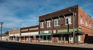
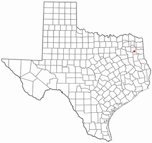
Ore City is a city in Upshur County, Texas, United States. The population was 1,108 at the 2020 census.

<span class="mw-page-title-main">Liberty Hill, Texas</span> City in Williamson County, Texas, United States

Liberty Hill is a city in Williamson County, Texas, United States. The population was 3,646 at the 2020 census. Liberty Hill is part of the Greater Austin metropolitan area.

<span class="mw-page-title-main">Aransas Pass, Texas</span> City in Texas, United States

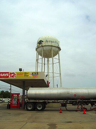
Aransas Pass is a city in Aransas, Nueces, and San Patricio Counties in the U.S. state of Texas. The population was 8,011 at the 2021 Census.

<span class="mw-page-title-main">Troup, Texas</span> City in Texas, United States

Troup is a city in Smith and Cherokee Counties in the U.S. state of Texas. Its population was 2,006 at the 2020 census. Troup lies in two counties in East Texas.

<span class="mw-page-title-main">Gladewater, Texas</span> City in Texas, United States

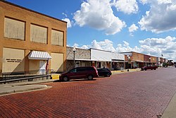
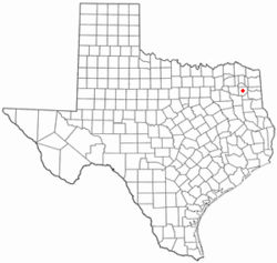
Gladewater is a city in Gregg and Upshur counties in the U.S. state of Texas with a 2020 census population of 6,134.

<span class="mw-page-title-main">Longview–Marshall combined statistical area</span>

The Longview–Marshall Combined Statistical Area covered four counties in Northeast Texas. The statistical area consists of the Longview Metropolitan Statistical Area and the Marshall Micropolitan Statistical Area. Prior to 2003, the area was known as the Longview–Marshall Metropolitan Statistical Area, which consisted of Gregg, Harrison, Rusk, and Upshur counties. As of the 2000 census, the CSA had a population of 256,152. In 2023, the Marshall micropolitan area was removed, and Harrison County was combined into the Longview metropolitan area.

References

  1. "2019 U.S. Gazetteer Files". United States Census Bureau. Retrieved August 7, 2020.
  2. 1 2 "U.S. Census website". United States Census Bureau . Retrieved January 31, 2008.
  3. "US Board on Geographic Names". United States Geological Survey. October 25, 2007. Retrieved January 31, 2008.
  4. "Find a County". National Association of Counties. Archived from the original on May 31, 2011. Retrieved June 7, 2011.
  5. "US Gazetteer files: 2010, 2000, and 1990". United States Census Bureau. February 12, 2011. Retrieved April 23, 2011.
  6. Climate Summary for Gilmer, Texas
  7. "NOWData - NOAA Online Weather Data". National Oceanic and Atmospheric Administration. Retrieved November 2, 2023.
  8. "Summary of Monthly Normals 1991-2020". National Oceanic and Atmospheric Administration. Retrieved November 2, 2023.
  9. "Census of Population and Housing". Census.gov. Retrieved June 4, 2015.
  10. "Explore Census Data". data.census.gov. Retrieved May 25, 2022.
  11. https://www.census.gov/ [ not specific enough to verify ]
  12. "About the Hispanic Population and its Origin". www.census.gov. Retrieved May 18, 2022.
  13. MICHELLE SHOCKED, TAKING STOCK – The Washington Post Retrieved 2018-04-17.
  14. Merline Pitre. "David Abner, Sr". Texas State Historical Association. Retrieved October 30, 2013.
  15. Michelle Shocked - Memories Of East Texas Lyrics Retrieved 2022-10-11.