Hillsboro, Texas | |
---|---|
Coordinates: 32°0′34″N97°7′28″W / 32.00944°N 97.12444°W | |
Country | United States |
State | Texas |
County | Hill |
Government | |
• Type | Council-manager government |
• Mayor | Edith Omberg [1] |
Area | |
• Total | 10.97 sq mi (28.42 km2) |
• Land | 10.87 sq mi (28.15 km2) |
• Water | 0.10 sq mi (0.27 km2) |
Elevation | 633 ft (193 m) |
Population (2020) | |
• Total | 8,221 |
• Density | 779.83/sq mi (301.08/km2) |
Time zone | UTC-6 (Central (CST)) |
• Summer (DST) | UTC-5 (CDT) |
ZIP code | 76645 |
Area code | 254 |
FIPS code | 48-34088 [3] |
GNIS feature ID | 1337816 [4] |
Website | www |
Hillsboro is a city in and the county seat of Hill County, Texas, United States. It is located between Dallas, Fort Worth and Waco, directly on Interstate 35 in North Central Texas. Hillsboro draws trade from throughout the county, and from Interstate 35 travelers between Dallas, Fort Worth, and Waco.
Quality of life, small town feel, competent government, and direct access routes to larger cities and airports are major factors in resident satisfaction. Jobs, services and employment in Hillsboro, Texas rank among the top rural cities in Texas.
Hillsboro is the gateway to Lake Whitney, Lake Whitney State Park, and nearby Lake Aquilla - all within a 15 minute drive from Hillsboro, Texas.
The city is a destination for heritage tourism, drawing visitors to its historic downtown main street district surrounding the Hill County Courthouse, and its historic residential district.
City of Hillsboro. In 1853, the Texas Legislature carved Hill County out of Navarro County. Named for physician and Republic of Texas Secretary of War Dr. George Washington Hill, the new county had only recently attracted Anglo settlement, following the establishment in 1848 of Fort Graham. County commissioners selected Hillsboro, originally spelled Hillsborough, as county seat. They established the town on land donated by Thomas Steiner, John Caruthers and Jonathan Newby, and the community soon had a school and post office, as well as a wood-frame courthouse. Cotton became the mainstay of Hillsboro’s late 19th-century economy. The city experienced rapid growth after the Missouri, Kansas & Texas Railroad and other lines came to the town in the early 1880s. In addition to bringing new settlers and giving access to shipping and transportation, railroads provided many new jobs. The city continued to grow and incorporated in 1881. The cotton industry produced a building boom between 1890 and 1910, as evidenced by the numerous Queen Anne homes still intact today, as well as the noted 1890 Hill County Courthouse. In 1923, the community established the Hillsboro Junior College, which over the years has become Hill College. Many Texas political leaders have come from Hillsboro, including U.S. Congressman Joseph Abbott and Texas Lt. Governor Bob Bullock, as well as Thomas Slater Smith, Robert Lee Bobbitt, Robert W. Calvert, Crawford C. Martin, Nelson Phillips and Sam Johnson. In 1981, Hillsboro became one of the Texas Historical Commission’s five original Texas Main Street Cities. The growing city continues to provide leadership, as well as natural, cultural and educational resources. Historical Marker Text, 2004. Located at 118 S Waco St.
The city of Hillsboro is served by the Hillsboro Independent School District.
Hill College, located in Hillsboro, provides high quality, comprehensive educational programs and services to enrolled students, the community, local workforce and area businesses and adult learners.
Hillsboro has private Christian academies and home school groups, in addition to the school district and college.
Hillsboro is a rural city located directly on Interstate 35 between Dallas-Fort Worth and Waco, Hillsboro's location offers residents and business significant advantages, and as the seat of Hill County, attracts trade from a 30+ mile radius of county cities, and a significant portion Interstate travelers. With an active and close knit community, Hillsboro's culture includes numerous events and programs continuously through the year for both residents and visitors.
Visit the Hillsboro, Texas Calendar of events
See the Hillsboro, Texas Community Links with Information about Hillsboro
Visit the official Hillsboro, Texas Eclipse 2024 website
Large annual events in Hillsboro include:
Climate data for Hillsboro, Texas (1991–2020 normals, extremes 1903–present) | |||||||||||||
---|---|---|---|---|---|---|---|---|---|---|---|---|---|
Month | Jan | Feb | Mar | Apr | May | Jun | Jul | Aug | Sep | Oct | Nov | Dec | Year |
Record high °F (°C) | 89 (32) | 97 (36) | 100 (38) | 101 (38) | 104 (40) | 109 (43) | 113 (45) | 112 (44) | 110 (43) | 103 (39) | 93 (34) | 90 (32) | 113 (45) |
Mean daily maximum °F (°C) | 59.0 (15.0) | 62.7 (17.1) | 69.5 (20.8) | 77.1 (25.1) | 84.1 (28.9) | 91.5 (33.1) | 96.0 (35.6) | 97.0 (36.1) | 90.5 (32.5) | 80.3 (26.8) | 68.8 (20.4) | 60.4 (15.8) | 78.1 (25.6) |
Daily mean °F (°C) | 46.5 (8.1) | 50.3 (10.2) | 57.2 (14.0) | 65.1 (18.4) | 73.1 (22.8) | 80.8 (27.1) | 84.4 (29.1) | 84.9 (29.4) | 78.3 (25.7) | 67.8 (19.9) | 56.3 (13.5) | 48.2 (9.0) | 66.1 (18.9) |
Mean daily minimum °F (°C) | 33.9 (1.1) | 37.8 (3.2) | 44.9 (7.2) | 53.0 (11.7) | 62.1 (16.7) | 70.0 (21.1) | 72.8 (22.7) | 72.8 (22.7) | 66.0 (18.9) | 55.2 (12.9) | 43.9 (6.6) | 36.1 (2.3) | 54.0 (12.2) |
Record low °F (°C) | −1 (−18) | −1 (−18) | 12 (−11) | 26 (−3) | 36 (2) | 48 (9) | 55 (13) | 53 (12) | 38 (3) | 21 (−6) | 14 (−10) | −6 (−21) | −6 (−21) |
Average precipitation inches (mm) | 2.74 (70) | 2.77 (70) | 3.57 (91) | 3.68 (93) | 4.51 (115) | 3.61 (92) | 1.65 (42) | 2.18 (55) | 3.15 (80) | 5.05 (128) | 2.73 (69) | 3.10 (79) | 38.74 (984) |
Average snowfall inches (cm) | 0.1 (0.25) | 0.3 (0.76) | 0.1 (0.25) | 0.0 (0.0) | 0.0 (0.0) | 0.0 (0.0) | 0.0 (0.0) | 0.0 (0.0) | 0.0 (0.0) | 0.0 (0.0) | 0.0 (0.0) | 0.2 (0.51) | 0.7 (1.8) |
Average precipitation days (≥ 0.01 in) | 7.4 | 7.1 | 8.0 | 7.1 | 8.6 | 6.6 | 4.2 | 4.5 | 5.6 | 6.9 | 3.8 | 7.4 | 80.2 |
Average snowy days (≥ 0.1 in) | 0.1 | 0.1 | 0.0 | 0.0 | 0.0 | 0.0 | 0.0 | 0.0 | 0.0 | 0.0 | 0.0 | 0.0 | 0.2 |
Source: NOAA [5] [6] |
Census | Pop. | Note | %± |
---|---|---|---|
1870 | 153 | — | |
1880 | 313 | 104.6% | |
1890 | 2,541 | 711.8% | |
1900 | 5,346 | 110.4% | |
1910 | 6,115 | 14.4% | |
1920 | 6,952 | 13.7% | |
1930 | 7,823 | 12.5% | |
1940 | 7,799 | −0.3% | |
1950 | 8,363 | 7.2% | |
1960 | 7,402 | −11.5% | |
1970 | 7,224 | −2.4% | |
1980 | 7,397 | 2.4% | |
1990 | 7,072 | −4.4% | |
2000 | 8,232 | 16.4% | |
2010 | 8,456 | 2.7% | |
2020 | 8,221 | −2.8% | |
U.S. Decennial Census [7] |
Race | Number | Percentage |
---|---|---|
White (NH) | 3,204 | 38.97% |
Black or African American (NH) | 1,109 | 13.49% |
Native American or Alaska Native (NH) | 19 | 0.23% |
Asian (NH) | 80 | 0.97% |
Pacific Islander (NH) | 6 | 0.07% |
Some Other Race (NH) | 21 | 0.26% |
Mixed/Multi-Racial (NH) | 237 | 2.88% |
Hispanic or Latino | 3,545 | 43.12% |
Total | 8,221 |
As of the 2020 United States census, there were 8,221 people, 2,925 households, and 2,024 families residing in the boundaries of Hillsboro Texas, however the population is thought to be far greater than the census numbers for the city reflect.
Hillsboro is located near the geographic center of Hill County at 32°0′34″N97°7′28″W / 32.00944°N 97.12444°W (32.009557, –97.124437). [13] Interstate 35 passes through the eastern side of the city, with access from Exits 364 through 370. The I-35E/I-35W split is just north of the city limits. Hillsboro is 56 miles (90 km) south of Fort Worth, 62 miles (100 km) southwest of Dallas, and 34 miles (55 km) north of Waco.
Texas State Highway 22 runs through the center of Hillsboro on West Elm Street, South Waco Street, and Corsicana Highway. It leads west 19 miles (31 km) to Lake Whitney and east 40 miles (64 km) to Corsicana. Texas State Highway 171 passes through Hillsboro with Highway 22, but leads northwest 29 miles (47 km) to Cleburne and southeast 23 miles (37 km) to Hubbard.
Fort Worth is a city in the U.S. state of Texas and the seat of Tarrant County, covering nearly 350 square miles (910 km2) into four other counties: Denton, Johnson, Parker, and Wise. According to a 2022 United States census estimate, Fort Worth's population was 956,709, the 5th-most populous in the state and the 13th-most populous in the United States. Fort Worth is the second-largest city in the Dallas–Fort Worth–Arlington metropolitan area, which is the fourth-most populous metropolitan area in the United States, and the most populous in Texas.
Interstate 35 (I-35) is a major Interstate Highway in the central United States. As with most primary Interstates that end in a five, it is a major cross-country, north–south route. It stretches from Laredo, Texas, near the Mexican border to Duluth, Minnesota, at Minnesota State Highway 61 and 26th Avenue East. The highway splits into I-35E and I-35W in two separate places, the Dallas–Fort Worth metroplex in Texas and at the Minnesota twin cities of Minneapolis–Saint Paul.
Navarro County is a county in the U.S. state of Texas. As of the 2020 census, the population was 52,624. Its county seat is Corsicana. The county is named for José Antonio Navarro, a Tejano leader in the Texas Revolution who signed the Texas Declaration of Independence.
McLennan County is a county located on the Edwards Plateau in Central Texas. As of the 2020 census, its population was 260,579. Its county seat and largest city is Waco. The U.S. census 2023 county population estimate is 268,583. The county is named for Neil McLennan, an early Scottish settler who worked to evict the Native Americans in frontier Texas. McLennan County is included in the Waco Metropolitan Statistical Area.
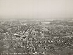
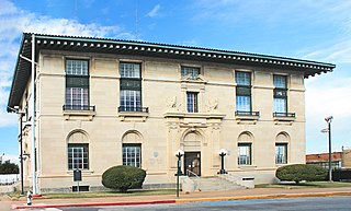
Hill County is a county in the U.S. state of Texas. As of the 2020 census, its population was 35,874. Its county seat is Hillsboro. The county is named for George Washington Hill, secretary of war and secretary of the navy under the Republic of Texas. Hill County is part of Central Texas, though not included in the Texas Hill Country.
Waxahachie is the county seat of Ellis County, Texas, United States. Its population was 41,140 in 2020. The city was founded in 1850, and incorporated in 1871. Much of the employment is provided by a number of industries and by educational institutions, including primary and secondary schools, a community college and a private university. In the mid-80's it became a filming location for a number of movies and occasional episodes of television series.
Sherman is a city in and the county seat of Grayson County, Texas, United States. The city's population in 2020 was 43,645. It is one of the two principal cities in the Sherman–Denison metropolitan statistical area, and is the largest city in the Texoma region of North Texas and southern Oklahoma.
Hubbard is a city in Hill County, Texas, United States. It was named for Texas Governor Richard B. Hubbard. The city is 42 miles (68 km) northeast of Waco.The population was 1,423 at the 2010 census, down from 1,586 at the 2000 census.
Greenville is a city in Hunt County, Texas, United States, approximately 50 miles (80 km) northeast of Dallas, Texas and 52 miles (84 km) northwest of Canton, Texas. It is the county seat and largest city of Hunt County. As of the 2020 census, the city population was 28,164.
The Dallas–Fort Worth metroplex, officially designated Dallas–Fort Worth–Arlington by the U.S. Office of Management and Budget, is the most populous metropolitan statistical area in the U.S. state of Texas and the Southern United States, encompassing 11 counties. Its historically dominant core cities are Dallas and Fort Worth. It is the economic and cultural hub of North Texas. Residents of the area also refer to it as DFW, or the Metroplex. The Dallas–Fort Worth–Arlington metropolitan statistical area's population was 7,637,387 according to the U.S. Census Bureau's 2020 census, making it the fourth-largest metropolitan area in the U.S. and the fifteenth-largest in the Americas. In 2016, the Dallas–Fort Worth metroplex had the highest annual population growth in the United States. By 2023, the U.S. Census Bureau estimated that the Dallas-Fort Worth metropolitan area's population had increased to 8,100,037, with the highest numerical growth of any metropolitan area in the United States.
U.S. Route 81 or U.S. Highway 81 (US 81) is a major north–south U.S. highway that extends for 1,220 miles (1,960 km) in the central United States and is one of the original United States Numbered Highways established in 1926 by the American Association of State Highway Officials.
U.S. Route 377 (US 377) is a 478-mile-long (769 km) north–south United States highway. Originally formed as a short spur to connect Denton, Texas with Fort Worth, Texas, it has since been extended to Oklahoma and Mexico.
Interstate 35E (I-35E), an Interstate Highway, is the eastern half of I-35, where it splits to serve the Dallas–Fort Worth metropolitan area. I-35 splits into two branch routes, I-35W and I-35E, at Hillsboro. I-35E travels north for 97 miles (156 km), maintaining I-35's sequence of exit numbers. It travels through Dallas before rejoining with I-35W to reform I-35 in Denton.
Interstate 35W (I-35W), an Interstate Highway, is the western half of I-35 where it splits to serve the Dallas–Fort Worth metropolitan area. I-35 splits into two branch routes, I-35W and I-35E, at Hillsboro. I-35W runs north for 85.2 miles (137.1 km), carrying its own separate sequence of exit numbers. It runs through Fort Worth before rejoining with I-35E to reform I-35 in Denton. It is the more direct route for long-distance expressway traffic, as is noted on signs on I-35 leading into the I-35W/I-35E splits. During the 1970s, billboards existed on I-35 encouraging travelers to take the faster and shorter I-35W route.
State Highway 81 is a Texas state highway that runs from Hillsboro to Grandview. It was designated in 1991 to replace U.S. Highway 81, which was decommissioned south of Fort Worth.
U.S. Highway 287 (US 287) in the U.S. state of Texas is a major U.S. Highway that begins on the Gulf Coast in Port Arthur and heads north through Fort Worth, northwest to Childress, Clarendon, Wichita Falls, and Amarillo in the Texas Panhandle and into Oklahoma near Kerrick.
U.S. Highway 75 (US 75) is a part of the U.S. Highway System that travels from Interstate 345 (I-345) in Dallas, Texas northward to the Canadian border at Noyes, Minnesota. In the state of Texas it runs from I-345 in Dallas and heads north to the Oklahoma state line.
U.S. Highway 81 is a U.S. Highway that begins at an interchange with Interstate 35W/US 287 (I-35W/US 287) in northern Fort Worth in Texas. US 81 leaves the state and crosses the Red River into Oklahoma between Ringgold, Texas, and Terral, Oklahoma.
Interstate 35 (I-35) is a major north–south Interstate Highway that runs from Laredo, Texas near the Mexican border to Duluth, Minnesota. In Texas, the highway begins in Laredo and runs north to the Red River north of Gainesville, where it crosses into Oklahoma. Along its route, it passes through the cities of San Antonio, Austin, and Waco before splitting into two branch routes just north of Hillsboro: I-35E heads northeast through Dallas, while I-35W turns northwest to run through Fort Worth. The two branches rejoin in Denton to again form I-35, which continues to the Oklahoma state line. The exit numbers for I-35E maintain the sequence of exit numbers from the southern segment of I-35, and the northern segment of I-35 follows on from the sequence of exit numbers from I-35E. I-35W maintains its own sequence of exit numbers.
Central Texas is a region in the U.S. state of Texas roughly bordered on the West by San Saba to the Southeast by Bryan and the South by San Marcos to the North by Hillsboro. Central Texas overlaps with and includes part of the Texas Hill Country and corresponds to a physiographic section designation within the Edwards Plateau, in a geographic context.
{{cite journal}}
: Cite journal requires |journal=
(help)