Centerville, Texas

Last updated

Centerville, Texas
Centerville Downtown WS (1 of 1).jpg
Store fronts in Centerville
TXMap-doton-CentervilleLeon.PNG
Location of Centerville, Texas
Leon County Centerville.svg
Coordinates: 31°15′23″N95°58′46″W / 31.25639°N 95.97944°W / 31.25639; -95.97944
Country United States
State Texas
County Leon
Area
[1]
  Total1.79 sq mi (4.62 km2)
  Land1.79 sq mi (4.62 km2)
  Water0.00 sq mi (0.00 km2)
Elevation
354 ft (108 m)
Population
 (2020) [2]
  Total905
  Density507.84/sq mi (196.12/km2)
Time zone UTC-6 (Central (CST))
  Summer (DST) UTC-5 (CDT)
ZIP code
75833
Area code 903
FIPS code 48-13900 [3]
GNIS feature ID1354216 [4]
Website centervilletx.gov

Centerville is a city in Leon County, in the U.S. state of Texas. The population was 905 at the 2020 census. [2] It is the county seat of Leon County. [5] Centerville was so named as it is near the geographic center of Leon County.

Contents

History

Centerville became the county seat of Leon County in 1850. [6] It was originally built on 200 acres donated by Robert J Townes and D.C. Carrington. [7]

The town established an annual Black-Eyed Pea Festival in 1937. [8]

Geography

According to the United States Census Bureau, Centerville has a total area of 1.5 square miles (3.9 km2), all land.

Climate

The climate in this area is characterized by hot, humid summers and generally mild to cool winters. According to the Köppen climate classification, Centerville has a humid subtropical climate, Cfa on climate maps. [9] The hottest temperature recorded in Centerville was 111 °F (43.9 °C) on August 12, 1948 and July 26, 1954, while the coldest temperature recorded was 0 °F (−17.8 °C) on February 1, 1951. [10]

Climate data for Centerville, Texas, 1991–2020 normals, extremes 1937–present
MonthJanFebMarAprMayJunJulAugSepOctNovDecYear
Record high °F (°C)89
(32)
94
(34)
98
(37)
99
(37)
98
(37)
106
(41)
111
(44)
111
(44)
110
(43)
97
(36)
96
(36)
87
(31)
111
(44)
Mean maximum °F (°C)76.6
(24.8)
80.0
(26.7)
84.6
(29.2)
88.2
(31.2)
92.2
(33.4)
96.5
(35.8)
99.6
(37.6)
100.7
(38.2)
97.8
(36.6)
91.3
(32.9)
83.7
(28.7)
78.2
(25.7)
101.8
(38.8)
Mean daily maximum °F (°C)59.5
(15.3)
63.4
(17.4)
70.3
(21.3)
77.5
(25.3)
84.1
(28.9)
90.5
(32.5)
94.0
(34.4)
94.9
(34.9)
89.1
(31.7)
80.1
(26.7)
69.2
(20.7)
60.7
(15.9)
77.8
(25.4)
Daily mean °F (°C)47.3
(8.5)
51.1
(10.6)
57.7
(14.3)
65.0
(18.3)
72.9
(22.7)
79.8
(26.6)
82.8
(28.2)
83.0
(28.3)
76.9
(24.9)
66.8
(19.3)
56.6
(13.7)
48.8
(9.3)
65.7
(18.7)
Mean daily minimum °F (°C)35.1
(1.7)
38.9
(3.8)
45.2
(7.3)
52.4
(11.3)
61.7
(16.5)
69.1
(20.6)
71.7
(22.1)
71.0
(21.7)
64.8
(18.2)
53.5
(11.9)
44.0
(6.7)
36.9
(2.7)
53.7
(12.0)
Mean minimum °F (°C)19.8
(−6.8)
24.3
(−4.3)
27.1
(−2.7)
35.9
(2.2)
45.9
(7.7)
60.2
(15.7)
65.2
(18.4)
63.8
(17.7)
51.1
(10.6)
37.2
(2.9)
27.0
(−2.8)
22.9
(−5.1)
17.9
(−7.8)
Record low °F (°C)5
(−15)
0
(−18)
15
(−9)
26
(−3)
36
(2)
48
(9)
52
(11)
52
(11)
39
(4)
27
(−3)
15
(−9)
1
(−17)
0
(−18)
Average precipitation inches (mm)3.47
(88)
3.22
(82)
3.90
(99)
3.11
(79)
4.65
(118)
4.00
(102)
2.47
(63)
2.71
(69)
3.22
(82)
4.22
(107)
3.63
(92)
3.81
(97)
42.41
(1,078)
Average snowfall inches (cm)0.0
(0.0)
0.1
(0.25)
0.0
(0.0)
0.0
(0.0)
0.0
(0.0)
0.0
(0.0)
0.0
(0.0)
0.0
(0.0)
0.0
(0.0)
0.0
(0.0)
0.0
(0.0)
0.0
(0.0)
0.1
(0.25)
Average precipitation days (≥ 0.01 in)7.07.67.15.66.66.84.75.36.16.06.97.977.6
Average snowy days (≥ 0.1 in)0.00.10.00.00.00.00.00.00.00.00.00.00.1
Source 1: NOAA [11]
Source 2: National Weather Service [10]

Demographics

Historical population
CensusPop.Note
1870 221
1880 2251.8%
1890 28828.0%
1930 388
1940 900132.0%
1950 9616.8%
1960 836−13.0%
1970 831−0.6%
1980 799−3.9%
1990 8121.6%
2000 90311.2%
2010 892−1.2%
2020 9051.5%
U.S. Decennial Census [12]
Centerville racial composition as of 2020 [13]
(NH = Non-Hispanic) [lower-alpha 1]
RaceNumberPercentage
White (NH)67774.81%
Black or African American (NH)13314.7%
Asian (NH)90.99%
Some Other Race (NH)20.22%
Mixed/Multi-Racial (NH)151.66%
Hispanic or Latino 697.62%
Total905

As of the 2020 United States census, there were 905 people, 371 households, and 239 families residing in the city.

At the 2000 census, 903 people, 388 households, and 230 families were living in the city. The population density was 620.9 inhabitants per square mile (239.7/km2). The 464 housing units had an average density of 319.0/sq mi (123.6/km2). The racial makeup of the city was 75.30% White, 21.82% African American, 0.33% Native American, 0.22% Asian, 1.66% from other races, and 0.66% from two or more races. Hispanics or Latinos of any race were 1.99%. [3]

Of the 388 households, 25.3% had children under 18 living with them, 46.4% were married couples living together, 10.3% had a female householder with no husband present, and 40.5% were not families. About 38.1% of households were one person, and 22.9% were one person aged 65 or older. The average household size was 2.17, and the average family size was 2.89.

The age distribution was 22.1% under 18, 6.3% from 18 to 24, 22.6% from 25 to 44, 25.0% from 45 to 64, and 23.9% 65 or older. The median age was 44 years. For every 100 females, there were 83.9 males. For every 100 females age 18 and over, there were 77.5 males.

The median income for a household was $25,677 and for a family was $35,278. Males had a median income of $38,125 versus $19,167 for females. The per capita income for the city was $15,469. About 14.9% of families and 19.1% of the population were below the poverty line, including 19.7% of those under age 18 and 20.9% of those age 65 or over.

Education

The City of Centerville is served by the Centerville Independent School District.

Notable people

Related Research Articles

<span class="mw-page-title-main">Leon County, Texas</span> County in Texas, United States

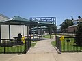
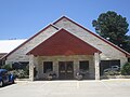
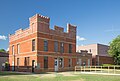
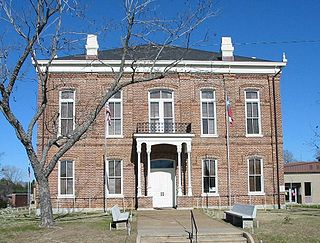
Leon County is a county in the U.S. state of Texas. As of the 2020 census, its population was 15,719. Its county seat is Centerville.

<span class="mw-page-title-main">Centerville, South Dakota</span> City in South Dakota, United States

Centerville is a city in Turner County, South Dakota, United States. The population was 918 at the 2020 census. Centerville is part of the Sioux Falls, South Dakota metropolitan area.

<span class="mw-page-title-main">Jourdanton, Texas</span> City in Texas, United States

Jourdanton is a city in and the county seat of Atascosa County, Texas, United States. The population is 4,094. It is part of the San Antonio metropolitan statistical area. The mayor is Robert "Doc" Williams. The city manager is Bobby J. Martinez. The police chief is Eric Kaiser. The fire chief is Jay Fojtik.

<span class="mw-page-title-main">Blanco, Texas</span> City in Texas, United States

Blanco is a city in rural Blanco County, Texas, United States. The population was 1,739 at the 2010 census. Blanco is a cattle and ranching community.

<span class="mw-page-title-main">Caldwell, Texas</span> City in Texas, United States

Caldwell is a city in and the county seat of Burleson County, Texas, United States. The population was 3,993 at the 2020 census. It is part of the Bryan-College Station metropolitan area.

<span class="mw-page-title-main">Dickens, Texas</span> City in Texas, United States

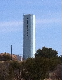
Dickens is a city in and the county seat of Dickens County, Texas, United States. The population was 286 at the 2010 census, down from 332 at the 2000 census.

<span class="mw-page-title-main">Benavides, Texas</span> City in Texas, United States

Benavides is a city in Duval County, Texas, United States. The population was 1,362 at the 2010 census, down from 1,686 at the 2000 census.

<span class="mw-page-title-main">Fairfield, Texas</span> City in Texas, United States

Fairfield is a city in Freestone County, Texas, United States. The population was 2,850 at the 2020 census, down from 3,094 at the 2000 census. It is the county seat of Freestone County and was founded as such in 1851.

<span class="mw-page-title-main">Hamilton, Texas</span> City in Texas, United States

Hamilton is a city in and the county seat of Hamilton County, Texas, United States, located in the state's central region. Its population was 3,096 at the 2010 census.

<span class="mw-page-title-main">Stinnett, Texas</span> City in Texas, United States

Stinnett is a city in and the county seat of Hutchinson County, Texas, United States. The population was 1,881 at the 2010 census, a decrease from 1,936 at the 2000 census.

<span class="mw-page-title-main">Buffalo, Texas</span> City in Texas, United States

Buffalo is a city in Leon County, Texas, United States. The population was 1,767 at the 2020 census.

<span class="mw-page-title-main">Jewett, Texas</span> City in Texas, United States

Jewett is a city in Leon County, Texas, United States. The population was 1,167 at the 2010 census. It was laid out in 1871 by the International Railroad Company.

<span class="mw-page-title-main">Goldthwaite, Texas</span> City in Texas, United States

Goldthwaite is a town and the county seat of Mills County, Texas, United States. The population was 1,878 at the 2010 census.

<span class="mw-page-title-main">Emory, Texas</span> City in Texas, United States

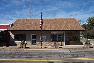
Emory is a city in Rains County, Texas, United States. The population was 1,239 at the 2010 census. It is the county seat of Rains County. Previously known as Springville, the city and county are named after Emory Rains, who was a legislator from the area. Rains was the author of the Homestead Law of Texas, which was later used as a model for the protection of homesteads throughout the United States. Special legislation passed to create Rains County called for the citizens to vote on the location of the county seat and for that selected town to be named Emory.

<span class="mw-page-title-main">El Campo, Texas</span> City in Texas, United States

El Campo is a city in Wharton County, Texas, United States. The population was 12,350 at the 2020 Census, making it the largest city in Wharton County.

<span class="mw-page-title-main">Wheeler, Texas</span> City in Texas, United States

Wheeler is a city, and the county seat of Wheeler County, Texas, United States, located on the eastern border of the Texas Panhandle. The population was last reported at 1,592 in the 2010 census.

<span class="mw-page-title-main">Horseshoe Bay, Texas</span> City in Texas, United States

Horseshoe Bay is a city in Llano and Burnet counties in the U.S. state of Texas.

<span class="mw-page-title-main">Oakwood, Texas</span> Town in Texas, United States

Oakwood is a town in Leon and Freestone counties in the U.S. state of Texas. The population was 389 at the 2020 census. It was founded in 1872 as a stop on the International Railroad.

<span class="mw-page-title-main">Gorman, Texas</span> City in Texas, United States

Gorman is a city in Eastland County, Texas, United States. Its population was 1,083 at the 2010 census, down from 1,236 at the 2000 census.

<span class="mw-page-title-main">Centerville, Kansas</span> Unincorporated community in Kansas, United States

Centerville is an unincorporated community in Linn County, Kansas, United States. As of the 2020 census, the population of the community and nearby areas was 78. It is located 8.5 miles (13.7 km) north of the city of Blue Mound.

References

  1. "2019 U.S. Gazetteer Files". United States Census Bureau. Retrieved August 7, 2020.
  2. 1 2 "Total Population: 2010 Census DEC Summary File 1 (P1), Centerville city, Texas". data.census.gov. U.S. Census Bureau. Retrieved January 20, 2021.
  3. 1 2 "U.S. Census website". United States Census Bureau . Retrieved January 31, 2008.
  4. "US Board on Geographic Names". United States Geological Survey. October 25, 2007. Retrieved January 31, 2008.
  5. "Find a County". National Association of Counties. Archived from the original on May 31, 2011. Retrieved June 7, 2011.
  6. "Centerville, Texas". Texas State Historical Association. Retrieved February 6, 2012.
  7. A Memorial and Biographical History of Navarro, Henderson, Anderson, Limestone, Freestone and Leon Counties, Texas. Chicago: Lewis Publishing Company. 1893. p. 463. Retrieved September 28, 2014.
  8. "Centerville, Texas". Centerville Chamber of Commerce. Archived from the original on February 1, 2012. Retrieved May 6, 2012.
  9. Climate Summary for Centerville, Texas
  10. 1 2 "NOAA Online Weather Data - NWS Dallas/Fort Worth". National Weather Service. Retrieved October 30, 2022.
  11. "U.S. Climate Normals Quick Access - Station: Centerville, TX". National Oceanic and Atmospheric Administration. Retrieved October 30, 2022.
  12. "Census of Population and Housing". Census.gov. Retrieved June 4, 2015.
  13. "Explore Census Data". data.census.gov. Retrieved May 25, 2022.
  14. "About the Hispanic Population and its Origin". www.census.gov. Retrieved May 18, 2022.
  1. Note: the US Census treats Hispanic/Latino as an ethnic category. This table excludes Latinos from the racial categories and assigns them to a separate category. Hispanics/Latinos can be of any race. [14]