Mount Pleasant, Texas | |
---|---|
Coordinates: 33°9′28″N94°58′12″W / 33.15778°N 94.97000°W | |
Country | United States |
State | Texas |
County | Titus |
Area | |
• Total | 15.99 sq mi (41.42 km2) |
• Land | 15.65 sq mi (40.53 km2) |
• Water | 0.34 sq mi (0.89 km2) |
Elevation | 404 ft (123 m) |
Population (2020) | |
• Total | 16,047 |
Time zone | UTC-6 (Central (CST)) |
• Summer (DST) | UTC-5 (CDT) |
ZIP codes | 75455-75456 |
Area code(s) | 903, 430 |
FIPS code | 48-49800 [2] |
GNIS feature ID | 1342094 [3] |
Website | mpcity |
Mount Pleasant is the county seat of and largest city in Titus County, [4] in the U.S. state of Texas. As of the 2020 census, Mount Pleasant's population was 16,047; it is situated in Northeast Texas.
Mount Pleasant was founded May 11, 1848, to serve as county seat for Titus County, which was created by a legislative act on May 11, 1846. Until after the Civil War, Titus County also included the territory of present-day Franklin and Morris Counties. High waters along the creeks and the Sulphur River often halted travel in the early years.
In the 21st century, Titus County comprises the Mount Pleasant micropolitan statistical area, named for the county seat.
Mount Pleasant is located at 33°9′28″N94°58′12″W / 33.15778°N 94.97000°W (33.157891, −94.970084). [5]
According to the United States Census Bureau, the city has a total area of 12.7 square miles (33.0 km2), of which 12.5 square miles (32.5 km2) are land and 0.4 square miles (1 km2) is covered by water.
Mount Pleasant is considered to have a humid subtropical climate.
Climate data for Mount Pleasant, Texas (1991–2020 normals, extremes 1905–present) | |||||||||||||
---|---|---|---|---|---|---|---|---|---|---|---|---|---|
Month | Jan | Feb | Mar | Apr | May | Jun | Jul | Aug | Sep | Oct | Nov | Dec | Year |
Record high °F (°C) | 86 (30) | 91 (33) | 92 (33) | 97 (36) | 106 (41) | 107 (42) | 112 (44) | 118 (48) | 109 (43) | 104 (40) | 91 (33) | 88 (31) | 118 (48) |
Mean daily maximum °F (°C) | 55.9 (13.3) | 59.7 (15.4) | 67.6 (19.8) | 75.2 (24.0) | 82.3 (27.9) | 89.6 (32.0) | 93.3 (34.1) | 94.1 (34.5) | 88.2 (31.2) | 77.9 (25.5) | 66.1 (18.9) | 57.7 (14.3) | 75.6 (24.2) |
Daily mean °F (°C) | 44.0 (6.7) | 47.7 (8.7) | 55.3 (12.9) | 62.5 (16.9) | 71.3 (21.8) | 78.8 (26.0) | 82.2 (27.9) | 82.3 (27.9) | 75.6 (24.2) | 64.5 (18.1) | 53.5 (11.9) | 45.9 (7.7) | 63.6 (17.6) |
Mean daily minimum °F (°C) | 32.0 (0.0) | 35.7 (2.1) | 42.9 (6.1) | 49.8 (9.9) | 60.2 (15.7) | 68.1 (20.1) | 71.1 (21.7) | 70.6 (21.4) | 63.1 (17.3) | 51.2 (10.7) | 40.9 (4.9) | 34.1 (1.2) | 51.6 (10.9) |
Record low °F (°C) | −5 (−21) | −12 (−24) | 11 (−12) | 23 (−5) | 34 (1) | 48 (9) | 50 (10) | 48 (9) | 36 (2) | 23 (−5) | 9 (−13) | −2 (−19) | −12 (−24) |
Average precipitation inches (mm) | 3.56 (90) | 4.18 (106) | 4.36 (111) | 4.55 (116) | 5.24 (133) | 4.32 (110) | 2.90 (74) | 2.66 (68) | 3.62 (92) | 4.61 (117) | 3.78 (96) | 4.79 (122) | 48.57 (1,234) |
Average snowfall inches (cm) | 0.6 (1.5) | 1.0 (2.5) | 0.1 (0.25) | 0.0 (0.0) | 0.0 (0.0) | 0.0 (0.0) | 0.0 (0.0) | 0.0 (0.0) | 0.0 (0.0) | 0.0 (0.0) | 0.0 (0.0) | 0.2 (0.51) | 1.9 (4.8) |
Average precipitation days (≥ 0.01 in) | 6.5 | 7.0 | 7.3 | 6.7 | 6.7 | 6.2 | 4.3 | 4.1 | 4.2 | 5.8 | 5.4 | 6.9 | 71.1 |
Average snowy days (≥ 0.1 in) | 0.3 | 0.4 | 0.1 | 0.0 | 0.0 | 0.0 | 0.0 | 0.0 | 0.0 | 0.0 | 0.1 | 0.2 | 1.1 |
Source: NOAA [6] [7] |
Census | Pop. | Note | %± |
---|---|---|---|
1870 | 275 | — | |
1880 | 452 | 64.4% | |
1890 | 963 | 113.1% | |
1910 | 3,137 | — | |
1920 | 4,099 | 30.7% | |
1930 | 3,541 | −13.6% | |
1940 | 4,528 | 27.9% | |
1950 | 6,342 | 40.1% | |
1960 | 8,027 | 26.6% | |
1970 | 9,459 | 17.8% | |
1980 | 11,003 | 16.3% | |
1990 | 12,291 | 11.7% | |
2000 | 13,935 | 13.4% | |
2010 | 15,564 | 11.7% | |
2020 | 16,047 | 3.1% | |
U.S. Decennial Census [8] |
Race | Number | Percentage |
---|---|---|
White (NH) | 4,459 | 27.79% |
Black or African American (NH) | 2,170 | 13.52% |
Native American or Alaska Native (NH) | 44 | 0.27% |
Asian (NH) | 176 | 1.1% |
Pacific Islander (NH) | 2 | 0.01% |
Some Other Race (NH) | 40 | 0.25% |
Mixed/multiracial (NH) | 330 | 2.06% |
Hispanic or Latino | 8,826 | 55.0% |
Total | 16,047 |
As of the 2020 United States census, 16,047 people, 5,553 households, and 3,896 families were residing in the city. As of the census [2] of 2000, 13,935 people, 4,558 households, and 3,208 families resided in the city. The population density was 1,112.0 inhabitants per square mile (429.3/km2). The racial makeup of the city was 56.70% White, 16.00% African American, 0.55% Native American, 0.84% Asian, 23.58% from other races, and 2.33% from two or more races. Hispanics or Latinos of any race were 40.65% of the population.
In the city, the age distribution was 31.2% under 18, 10.9% from 18 to 24, 28.1% from 25 to 44, 16.2% from 45 to 64, and 13.6% who were 65 or older. The median age was 20 years. For every 100 females, there were 94.8 males. For every 100 females 18 and over, there were 89.6 males.
The median income for a household in the city was $28,805, and for a family was $32,331. Males had a median income of $22,629 versus $17,080 for females. The per capita income for the city was $14,190. About 20.3% of families and 22.8% of the population were below the poverty line, including 30.7% of those under age 18 and 16.1% of those age 65 or over.
Mount Pleasant has grown since the 2000 Census; as of 2010, Mount Pleasant had a population of 15,564.
The majority of the City of Mount Pleasant is served by the Mount Pleasant Independent School District. The southeastern portion is served by the Chapel Hill Independent School District. A smaller portion is served by the Harts Bluff Independent School District. [12]
Northeast Texas Community College is also located in Mount Pleasant, near the Chapel Hill school district.
The Mount Pleasant Tribune is a weekly newspaper which was founded in 1941.
A major project underway to build a 271 loop bypass around Mount Pleasant was completed in 2015.
The Mount Pleasant Regional Airport is located three miles from the city.
The City of Mount Pleasant is served by Titus Regional Medical Center.
The United States Postal Service operates the Mount Pleasant Post Office. [13]
The Texas Department of Criminal Justice (TDCJ) operates the Mount Pleasant District Parole Office in Mount Pleasant. [14]
Wichita County is a county located in the U.S. state of Texas. As of the 2020 census, its population was 129,350. The county seat is Wichita Falls. The county was created in 1858 and organized in 1882. Wichita County is part of the Wichita Falls, Texas, TX metropolitan statistical area.
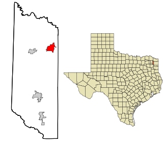
Titus County is a county located in the northeastern region of the U.S. state of Texas. As of the 2020 census, its population was 31,247. Its county seat is Mount Pleasant. The county is named for Andrew Jackson Titus, an early settler. Titus County comprises the Mount Pleasant micropolitan statistical area.
Morris County is a county located near the eastern border of the U.S. state of Texas. As of the 2020 census, its population was 11,973. Its county seat is Daingerfield. Morris County is probably named for William Wright Morris, an early judge and planter from Henderson, also in northeast Texas. As of 2016, Morris County is no longer one of six entirely dry, prohibition counties in the state of Texas. Morris County is "partially wet."
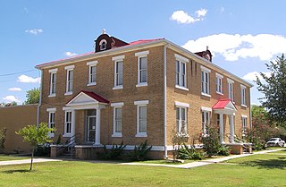
McMullen County is a county located in the U.S. state of Texas. As of the 2020 census, its population was 600, making it the fourth-least populous county in Texas. Its county seat is Tilden. The county was established from parts of Bexar County, Atascosa County, and Live Oak County in 1858 and later organized in 1877. It is named for John McMullen, founder of a colony in Texas. The McMullen County Courthouse was designed by the architect W.C. Stephenson, originally from Buffalo, New York. Stephenson also designed some 50 buildings in Beeville, including the Bee County Courthouse.
Houston County is a county located in the U.S. state of Texas. As of the 2020 census, its population was 22,066. Its county seat is Crockett. Houston County was one of 46 entirely dry counties in the state of Texas, until voters in a November 2007 special election legalized the sale of alcohol in the county.
Gregg County is a county located in the eastern part of the U.S. state of Texas. As of the 2020 census, its population was 124,239. Its county seat is Longview. The county is named after John Gregg, a Confederate general killed in action during the American Civil War.
Glasscock County is a county located in the U.S. state of Texas. As of the 2020 census, its population was 1,169. Its county seat is Garden City. The county was created in 1827 and later organized in 1869. It is named for George Washington Glasscock, an early settler of the Austin, Texas area and the namesake of Georgetown, Texas.
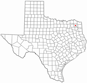
Franklin County is a county located in the U.S. state of Texas. As of the 2020 census, its population was 10,359. The county seat is Mount Vernon.
Crawfordville is a city in Taliaferro County, Georgia, United States. The population was 479 in 2020. The city is the county seat of Taliaferro County.
Maud is a city in Bowie County, Texas, United States, within the Texarkana metropolitan area. According to the 2020 U.S. census, it had a population of 977.
New Boston is a city in Bowie County, Texas, United States. Boston was named for an early storekeeper in the settlement, W.J. Boston. The coming of the railroads led to the location of two more Bostons. A depot was built approximately four miles north of Boston and was named New Boston. The original Boston then became Old Boston. The courthouse was moved to Texarkana in the early 1880s, but a later election carried to move the courthouse back to the geographic center of the county. This location was between the Bostons. The Post Office Department named this location Boston, so Bowie County has claim to three Bostons: New Boston, Boston, and Old Boston. The population was 4,550 at the 2010 census, and 4,612 in 2020.
Dimmitt is a city and county seat in Castro County, Texas, United States. Its population was 4,393 at the 2010 census.
Mount Vernon is a town and the county seat of Franklin County, Texas, United States. The population was 2,491 at the 2020 United States census.
Haskell is a city in central Haskell County, Texas, United States. As of the 2010 census, the city population was 3,322. It is the Haskell county seat.
Daingerfield is a city and the county seat of Morris County, Texas, United States. The population was 2,560 at the 2010 census.
Naples is a city in Morris County, Texas, United States. The population was 1,378 at the 2010 census.
Friona is a city in Parmer County, Texas, United States. The population was 4,171 at the 2020 census. Friona was established as a small community in 1898 by XIT Ranch, originally called Frio, which is also the word for "cold" in Spanish.
San Augustine is the county seat city of San Augustine County, Texas, in East Texas, United States. The population was 1,920 at the 2020 census.
Miller's Cove is a town in Titus County, Texas, United States. The population was 149 at the 2010 census.
Winfield is a small city in Titus County, Texas, United States. The population was 524 at the 2010 census.