January 2008 North American storm complex

Last updated
January 2008 North American superstorm
January 2008 North American Superstorm at peak intensity.jpg
The January 2008 North American Superstorm nearing peak intensity, on January 4, 2008
Type Extratropical cyclone
Superstorm
Coastal storm
Winter storm
Blizzard
Tornado outbreak
FormedDecember 29, 2007 (2nd storm formed)
DissipatedJanuary 22, 2008 (3rd storm dissipated) [1]
Highest gust165 mph (266 km/h) at Tahoe City, California
Lowest pressure956 millibars (28.2 inHg) [2]
Tornadoes
confirmed
55 confirmed
Max. rating1 EF3 tornado
Maximum snowfall
or ice accretion
132 inches (340 cm) of snow at Kirkwood Ski Resort, California [3]
Maximum rainfall10 inches (250 mm) of rain in Loma Prieta, California [4]
37.7-foot (11.5 m) waves [5]
FatalitiesAt least 16 fatalities
1 missing [ citation needed ]
DamageAt least $129 million [6]
Power outages>1.2 million [7]
Areas affected Eastern Russia, Alaska, Contiguous United States, Canada, Northern Mexico, Iceland, United Kingdom, Northern Europe, European Russia

1Most severe tornado damage; see Enhanced Fujita scale

The January 2008 North American storm complex was a powerful Pacific extratropical cyclone that affected a large portion of North America, primarily stretching from western British Columbia to near the Tijuana, Mexico area, starting on January 3, 2008. The system was responsible for flooding rains across many areas in California along with very strong winds locally exceeding hurricane force strength as well as heavy mountain snows across the Cascade and Sierra Nevada mountain chains as well as those in Idaho, Utah and Colorado. The storms were responsible for the death of at least 12 people across three states, and extensive damage to utility services as well, as damage to some other structures. The storm was also responsible for most of the January 2008 tornado outbreak from January 7–8.

Contents

Meteorological synopsis

The strong low-pressure system responsible for much of the extreme weather traversed much of the Pacific Ocean, before the first storm arrived late on January 3. (This storm was actually a part of a series of three storms.) On December 29, 2007, a powerful extratropical disturbance developed over eastern Siberia, which emerged into the northwest Pacific, and moved to the Aleutian Islands as a well-defined low by January 3. On January 2, another extratropical disturbance developed within a well-defined trough of low pressure, in the northeast Pacific Ocean. [8] On January 3, the 1st storm system approached the northern part of the West Coast, powered by a Pineapple Express atmospheric river, resulting in heavy downpours of rain and strong gusts across much of the Western Seaboard. [9] Late on January 3, the 2nd storm system in the Gulf of Alaska split, with the 3rd, new storm to the south usurping the majority of the moisture of the 2nd system. [10] On January 4, as the 1st storm system weakened, and the southern part of the storm split off into another storm, which began moving eastward across the Southern United States. [11] Later on the same day, as the first storm began moving ashore in British Columbia, [12] the 3rd (and the most powerful) storm brought the largest bands of snow and rain, which impacted the Pacific Coast from British Columbia to northern Mexico, on January 4. Heavy downpours of rain, heavy snow, and fierce winds lashed the West Coast. [4] Meanwhile, the 2nd storm system slowly moved eastward along the southern coast of Alaska, before stalling in the Gulf of Alaska on January 5. [13] From January 4 to 5, general rainfall from the superstorm in the West Coast was around 2 inches (51 mm) of rain in Oregon and Utah, while nearly 4 inches (100 mm) fell over parts of Nevada and as much as 10 inches (250 mm) in parts of California. Snowfall amounts for those two days reached as much as 70 inches (1,800 mm) in Blackcap Basin, California, while many mountain regions of California, Nevada and Idaho received between 1 and 5 feet (1.5 m) of snow. By this time, the 3rd storm's explosive intensification had transformed the system into a massive superstorm, becoming the dominant system in the Western US. Widespread hurricane-force wind gusts were reported across most western states with winds reaching speeds of 100 mph (160 km/h) or more. [14] The highest reported wind gusts were 165 mph (266 km/h) in Tahoe City, California, equivalent to a Category 5 hurricane on the Saffir- Simpson scale. [4] [15] Waves were reported as high as 37.7 feet (11.5 m) offshore Washington State. [5] Early on January 5, the superstorm reached a minimum low pressure of 956 millibars (28.2 inHg) - the pressure equivalent of a Category 3 hurricane, becoming the most powerful storm on record to affect the West Coast, in terms of low pressure. [2] Later on the same day, the 3rd storm began to interact with the 1st storm, which was situated over northwestern Canada, weakening that system. [16] Also, the superstorm slowly began to weaken, and it developed a secondary low to the north of Montana, as the system gradually began to split. [17] Late on January 6, the superstorm's secondary low became the dominant low in the system, as the storm system's circulation began to break down. [18] On January 6, the superstorm's original low pressure center was absorbed into the 2nd storm, located just south of Alaska, while the main bulk of the storm system continued moving eastward, across Western Canada. [19] However, the western chunk of the storm complex's moisture continued to dump rain and snow across the Western US. On the afternoon of January 6, Kirkwood Ski Resort reported 10 feet (3.0 m) of snow in 48 hours with a storm total of 11 feet. [3]

On January 7, the storm complex weakened further, and the circulation in the western half of the storm completely collapsed, resulting in the storm's moisture spreading out throughout most of the Western United States. Soon afterwards, a few clumps of the mass of moisture organized into separate storm systems, [20] while the dominant low over Canada stalled just southwest of Hudson Bay. As the storm complex moved westward on January 7, the instability in the air triggered a rare January tornado outbreak, spawning 55 tornadoes over the course of 2 days, resulting in the deaths of 4 more people. On January 8, the western fragment of the complex in the US dissipated, while the southern and eastern chunks continued to organize. [21] On the same day, the 2nd storm system in the Gulf of Alaska was absorbed by another more powerful incoming extratropical cyclone, even as the main storm complex continued heading eastward across the United States. [22] Later on January 8, the eastern chunk of the storm complex merged into the southern chunk, while the low near Hudson Bay began to deteriorate. [23] On January 9, the low pressure center over the Great Lakes region became the dominant low of the storm complex. [24] On the same day, the 1st storm over northern Canada was absorbed by a cold front, even as the storm complex continued to organize over the Eastern United States, triggering more tornadoes across the region. [25] By January 9, the storm complex had organized into a 973 mbar (28.7 inHg) storm to the northeast of the Great Lakes, and it began to strip away moisture from the low near Hudson Bay. [26] The storm complex slowly moved northeastward, and the storm's outer rainband eventually exited the East Coast. On January 10, the low west of Hudson Bay dissipated, while the main storm complex began to exit Atlantic Canada. [27] On January 11, the storm entered Labrador Sea, [28] and stalled for several hours, before continuing to move northeastward. At the same time, the system gradually weakened. On January 12, the system reorganized to the southeast of Greenland, and was assigned the name Ilse by the Free University of Berlin. [29] On January 14, Windstorm Ilse intensified to 980 millibars (29 inHg) and impacted the United Kingdom and parts of Western Europe, before entering the Norwegian Sea on January 15. [30] During the next couple of days, Ilse accelerated northeastward, [31] before turning to the east on January 17. [32] On January 22, Ilse was absorbed by another extratropical cyclone to the south, over the Barents Sea. [1]

Impacts

Satellite image of the system as it approached the West Coast (Courtesy of NWS Hanford, California) January 4 superstorm.gif
Satellite image of the system as it approached the West Coast (Courtesy of NWS Hanford, California)

Flights departing from San Francisco were grounded, while over 100 miles (160 km) of Interstate 80 was shut down in eastern California and western Nevada due to poor visibility and a 17-vehicle pile-up. Bay Area Rapid Transit was also disrupted with significant delays to service and was even interrupted between San Francisco and Daly City briefly due to fallen trees on the network's tracks. [33]

Strong winds knocked power lines down causing power outages for 1.2 million Californians, [7] while several outages were reported in Washington and Oregon. [34] About 500 miles (800 km) of California power lines were damaged by the storm. [35]

The storm closed ski resorts, toppled trees, and created mudslides. Highways from Sacramento to San Francisco were closed by debris. Meteorologists predicted about 10 feet (3.0 m) of snow by the end of the storms giving hope to Californians for more water for the year of 2008 following a drier than average 2007 water season and leading to an expected water shortage in 2008. Mandatory evacuations were ordered in Orange County in Southern California. [36] On January 5, a canal levee ruptured near Reno, Nevada and flooded some 800 residences. [37] At least 3000 people were rescued by helicopter from rooftops of flooded homes while cold temperatures hindered rescue efforts. [38]

Nevada Governor Jim Gibbons declared a state of emergency for Lyon County. The Federal Emergency Management Agency was called in for emergency assistance and distribution of food and water. Bank firm Wells Fargo opened an account to collect donations for the residents of Fernley. Residents began returning home on January 7. [39] [40] California Governor Arnold Schwarzenegger also declared a state of emergency for three counties while Oregon Governor Ted Kulongoski declared a state of emergency for Umatilla County due to wind damage. At least 12 people were killed including two in California, eight in Utah and two in Oregon due to falling branches or trees, traffic accidents, and flooding. [41] [42] [43] [44] Eight of the fatalities were caused by the rollover of a charter bus in southeastern Utah. [45] 7 people in one California home were hospitalized for carbon monoxide poisoning from a lantern. [46] Several other people, including snowmobilers and skiers, were missing in the mountain regions of Colorado. Six snowmobilers were later found alive after calling for emergency services from a train station. A hiker went missing in the San Bernardino Mountains. [47] [48] [49] According to an analysis conducted by meteorologists, a storm of this intensity had not struck California since the 1997–1998 North American winter storm season (as of December 2009).[ citation needed ]

Tornadoes

Confirmed tornadoes by Enhanced Fujita rating
EFUEF0EF1EF2EF3EF4EF5Total
02421640055

January 7 event

List of reported tornadoes – Monday, January 7, 2008
EF# LocationCountyTime (UTC)Path lengthDamage
Missouri
EF0SW of Lowry City St. Clair 2022unknownBrief tornado damaged a few trees. [50]
EF0SE of Lincoln Benton 2054unknownA pole barn was heavily damaged. [51]
EF0NE of Auxvasse Audrain 21550.5 mile
(800 m)
Tornado damaged a machine shed, along with numerous trees and tree limbs. [52]
EF2N of Purdy Barry 230612 miles
(19.2 km)
Intermittent tornado passed between Purdy and Monett. Houses and farm buildings were damaged along the path, and eight mobile homes were destroyed at a mobile home park. [53]
EF0E of Pineville McDonald 23500.1 mile
(160 m)
Tornado caused minor tree damage. [54]
EF2 Northern Republic to SW of Brookline Greene 23576 miles
(9.6 km)
Tornado impacted the northern part of Republic, where many homes were damaged, 15 of which sustained major damage or were destroyed. An Elementary School sustained major roof damage towards the end of the path before the tornado dissipated. [55]
EF3W of Strafford to E of Abo Greene, Webster, Laclede 002926 miles
(42 km)
3 deaths – Tornado began west of Strafford and passed north of town, destroying several frame homes and outbuildings. Additional frame homes were destroyed near Marshfield, along with barns and mobile homes. A semi-truck was flipped as the tornado crossed Interstate 44, and severe damage occurred in the nearby ghost town of Sampson. Numerous additional homes and outbuildings were destroyed, and multiple injuries occurred near Lebanon before the tornado dissipated. Two of the fatalities occurred in frame homes, and the other occurred in a mobile home. Over 50 homes, mobile homes, and outbuildings were destroyed along the path, numerous power poles and large trees were snapped, and 18 people were injured. [56]
EF0NE of Aurora Lawrence, Christian 01286 miles
(9.6 km)
Farmhouses and outbuildings were damaged along the path. [57]
EF2SW of Strafford to W of Marshfeield Greene, Webster 013217 miles
(29 km)
Tornado tracked just south of the previous Strafford area EF3, paralleling Interstate 44 and crossing it several times. Homes and outbuildings were heavily damaged along the path. [58]
EF0S of Mount Sterling Gasconade 01500.25 mile
(400 m)
Brief tornado touchdown caused tree damage. [59]
EF3NW of Hooker to NE of Jerome Pulaski, Phelps 02067 miles
(11 km)
Near the beginning of the path, a few homes and several outbuildings were destroyed in rural areas. The tornado clipped the north side of Jerome before dissipating, where one home and multiple additional outbuildings were destroyed. [60]
EF1NW of Mayflower McDonald, Barry 02157 miles
(11.2 km)
A few structures were heavily damaged or destroyed, along with numerous trees. [61]
EF0W of Clarksville Pike 02305 miles
(8 km)
Intermittent tornado touchdown caused some tree damage. [62]
EF1NE of Marshfield Webster, Dallas 02426 miles
(9.6 km)
One house was damaged along with a few outbuildings. [63]
EF2NW of Phillipsburg Laclede 03005 miles
(8 km)
Several outbuildings were destroyed and one house was heavily damaged. Numerous trees were uprooted as well. [64]
EF0W of Seligman Barry 031220 yds
(18 m)
Very short-lived tornado knocked a few trees down. [65]
EF1NW of Highlandville Christian 03361.5 miles
(2.4 km)
Two mobile homes were destroyed and several houses were damaged. One person was injured by flying debris. [66]
EF1W of Vichy Phelps, Maries 034013 miles
(21 km)
35 to 45 structures were damaged, with one home partially moved off its foundation and portions of the roof thrown up to a quarter of a mile away. Wind gusts of up to 84 knots were recorded by the Vichy Automated Weather Station, and a few airplanes were damaged nearby at the airport. A mobile home was destroyed as well and one person was injured. [67]
EF0E of Rogersville to NE of Diggins Webster 035711 miles
(17 km)
Tornado caused minor damage to trees and outbuildings along its path. [68]
EF1SW of Mountain McDonald, Barry 04219 miles
(15 km)
Tornado damaged trees and structures, a few of which were removed from their foundations. [69] [70]
Illinois
EF3N of Poplar Grove to NE of Lawrence Boone, McHenry 213013.2 miles
(21 km)
Tornado initially caused minor damage to trees and a shed before striking an apple orchard at EF2 strength, where large trees were snapped and uprooted, a large barn was destroyed, and other buildings were severely damaged. EF3 damage occurred at a nearby farmstead as a poorly-anchored farmhouse was swept away with only the basement remaining, and large trees on the property were denuded (though overall context was not consistent with a violent tornado). Hay bales were rolled through fields as well. The tornado weakened further along the path, causing minor EF0 and EF1 damage to farmhouses, trees, power lines, barns, and sheds. The tornado strengthened again, reaching EF2 strength as it struck the small town of Lawrence, where extensive tree damage occurred, a house had more than half its roof torn off and its detached garage destroyed, other homes sustained shingle damage, and a train carrying hazardous materials was derailed, resulting in an evacuation of the town. Past Lawrence, the tornado overturned a semi-truck and caused EF1 damage to barns and trees before dissipating. It was the first tornado in northeastern Illinois in the month of January since 1950. Five people were injured. [71] [72]
EF1S of Mackinaw Tazewell 23223 miles
(4.8 km)
Tornado destroyed a pole barn and damaged a house, along with a few outbuildings. In addition, a chain link fence and a few tree limbs were blown down. [73]
EF0SE of Pleasant Hill Pike 02402.75 miles
(4.4 km)
Intermittent tornado caused some tree damage. [74]
Wisconsin
EF3SE of Walworth to NW of Paddock Lake Walworth, Kenosha 220210.8 miles
(17 km)
This was the northernmost January tornado in the US since 1967. Near Walworth, the tornado uprooted trees and caused minor EF1 damage to homes and outbuildings. The tornado rapidly intensified to high-end EF3 strength, tearing through multiple subdivisions as it struck Wheatland, where 25 homes were destroyed, 27 sustained major damage, 25 sustained minor damage, and 7 were affected in some way. Further along the path, the tornado impacted the small town of Brighton, where 4 homes were destroyed, 3 sustained major damage, 3 sustained minor damage, and 10 were affected in some way. A large barn was destroyed before the tornado dissipated near Paddock Lake. Numerous large trees were snapped and denuded along the path, and 15 people were injured. Some of the homes destroyed were leveled, though they were poorly anchored and context did not support a rating higher than EF3. [75] [76]
EF1 Northern Kenosha Kenosha 22392.4 miles
(3.9 km)
Rope tornado tracked through the northern part of Kenosha. 5 homes were left uninhabitable, 6 sustained major damage, and 21 others sustained minor damage. Power lines were toppled and numerous trees were snapped or uprooted as well. [77]
Arkansas
EF0S of Hiwasse Benton 0205unknownBrief tornado remained over open country, causing no damage. [78]
EF0E of Centerton Benton 0250unknownBrief tornado remained over open country, causing no damage. [79]
EF1SW of Decatur Benton 05092.6 miles
(4.2 km)
Tornado caused extensive tree damage. [80]
Oklahoma
EF0SW of Watts Adair 0208unknownBrief tornado remained over open country, causing no damage. [81]
EF0N of Moodys Cherokee 0428unknownTornado caused roof damage to homes, damaged several barns, and uprooted trees. [82]
EF0NE of Porter Wagoner 05381 miles
(1.6 km)
Tornado caused extensive tree damage. [83]
EF0NE of Wagoner Wagoner 05542.7 miles
(4.4 km)
Tornado caused extensive tree damage. [83]
Sources: Storm reports of January 7, 2008, NWS Milwaukee, NWS Springfield, KY3 News, NWS Chicago, NWS St. Louis, NWS Tulsa

January 8 event

List of reported tornadoes – Tuesday, January 8, 2008
EF# LocationCountyTime (UTC)Path lengthDamage
Missouri
EF1NE of Washburn Barry 08227 miles
(11 km)
Several houses and outbuildings were damaged, along with numerous trees. [84]
EF1E of Cassville Barry, Stone 083114 miles
(22 km)
Several poultry barns, sheds, and outbuildings were heavily damaged or destroyed, and numerous trees were downed. [85]
EF1 Springfield Greene 08371 mile
(1.6 km)
Tornado moved through the northern part of downtown Springfield, causing a warehouse to collapse. Several homes sustained minor damage, and a Krispy Kreme sign was destroyed. [86]
EF1 Highlandville Christian 08505 miles
(8 km)
Tornado tracked through town, damaging several homes and a church. Several outbuildings and highway signs were destroyed as well. [87]
EF0 Branson to Hollister Taney 09012.88 miles
(90 m)
Tornado touched down at the Thousand Hills Resort in Branson, damaging three condominiums. In Hollister, a mobile home park was damaged. [88]
EF0SW of Bracken to SW of Susanna Webster 09167 miles
(11.2 km)
Tornado embedded in a squall line caused minor tree and structure damage. [89]
EF0SW of Tigris to SE of Mount Zion Douglas 091710 miles
(16 km)
Barns and outbuildings were damaged or destroyed, and multiple trees were uprooted or snapped. [90]
EF2S of Niangua Webster 09185 miles
(8 km)
Several homes and outbuildings were destroyed. [91]
EF1SW of Mountain Grove Douglas 09431.5 miles
(2.4 km)
One mobile home was moved from its foundation, a barn and some outbuildings were damaged, and significant tree damage occurred. [92]
EF1SE of Dawson to SE of Bado Wright, Texas 094512 miles
(19.2 km)
A few barns and outbuildings were damaged along the path. [93]
EF0W of West Plains Howell 1020unknownBrief tornado damaged two outbuildings and a mobile home. [94]
EF1SW of Eminence Shannon 10271.5 miles
(2.4 km)
Numerous trees were snapped or uprooted, but no structures were impacted along the path. [95]
EF1NE of Eminence Shannon 103810 miles
(16 km)
Two barns and a garage were destroyed, and another barn was damaged. Numerous trees were snapped or uprooted as well. [96]
EF0SW of Alton Oregon 10591 mile
(1.6 km)
Tornado damaged a few outbuildings south of Alton. A motorcycle shop sustained the most damage as a barn that sheltered several new motorcycles was destroyed. [97]
EF1NE of Essex Stoddard 18404.2 miles
(6.8 km)
One house was heavily damaged, with part of the roof torn off and debris scattered 100 to 200 yards. Three outbuildings and an equipment shed were destroyed, and a trailer was thrown about 75 yards. Approximately ten power poles were snapped in half, vehicle windows were blown out, and a few large trees were snapped. A pump house was blown into a propane tank, causing a propane leak as well. [98]
Arkansas
EF2SW of Appleton to W of Beverage Town Pope, Conway, Van Buren 144020.5 miles
(33 km)
1 death – Major damage occurred near Appleton, with 42 homes damaged in that area. Of these, seven were destroyed, six had minor damage, and the rest had moderate to heavy damage. In addition, six chicken houses, two barns, and a number of outbuildings were destroyed, a travel trailer and motor home were overturned, and hundreds of trees were blown down. A man was killed when his mobile home was destroyed in this area. Near Jerusalem, 3 homes were destroyed, and 12 others suffered damage ranging from light to heavy. Ten other structures, such as chicken houses and barns were destroyed, with 13 such structures damaged. A church was destroyed and an adjacent cemetery was damaged in this area as well. Three natural gas well sites were also damaged but there was no release of gas. The tornado moved into the Ozark National Forest, where hundreds of trees were blown down before it dissipated. Two other people were injured. [99]
EF0SE of Princedale to SE of Twist Cross 192611 miles
(17.6 km)
A mobile home lost its roof, irrigation sprinklers were blown over, and trees and power lines were knocked down. [100]
EF1S of Deckerville Poinsett 1952250 yds
(225 m)
Brief touchdown damaged two houses and destroyed a shed. Numerous trees were downed and debris was scattered across a nearby field. [101]
EF1S of Osceola Mississippi 20203.5 miles
(5.6 km)
Numerous home sustained roof damage and many trees were downed. A metal farm equipment building was shifted from its foundation, and a vehicle was destroyed as well. [102]
Tennessee
EF1NE of Double Bridges to NW of Bonicord Lauderdale, Dyer 20587 miles
(11 km)
Multiple homes were damaged, including two that had their roofs blown off, one of which was shifted off of its foundation. Outbuildings, fences, garages, and machine sheds were destroyed as well. A mobile home was also destroyed, and many trees and power lines were downed. [103]
Mississippi
EF0S of Church Hill Jefferson 21304 miles
(6.4 km)
Trees were downed in a convergent pattern. [104]
EF1NW of Harrisville to E of Everett Simpson 233720 miles
(32 km)
A house had a large section of its roof torn off, and nearby outbuilding was blown away and destroyed. Another home and several outbuildings sustained lesser damage. Extensive tree damage occurred along the path. [105]
EF0SE of Puckett Rankin 0011unknownSeveral trees were downed and a home sustained shingle damage. [106]
Sources: Storm reports of January 8, 2008, NWS Little Rock, NWS Paducah, NWS Jackson (MS), NWS Memphis

See also

Related Research Articles

<span class="mw-page-title-main">Wisconsin tornado outbreak of 2005</span>

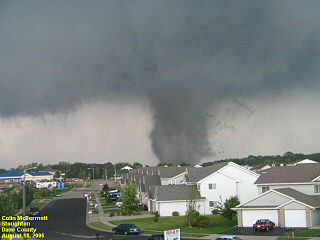
The Wisconsin tornado outbreak of 2005 was an outbreak of tornadoes that occurred primarily in southern Wisconsin on August 18, 2005. A system of storms unleashed a total of 28 tornadoes, 27 of which were confirmed in southern Wisconsin, and 1 confirmed in Minnesota. This outbreak set a new record for the most tornadoes observed in the state in a single day, breaking the previous record of 24 tornadoes set on May 8, 1988. The system generating the Stoughton tornado was also accompanied by many reports of severe winds and hail throughout the region. The Stoughton tornado was documented on an episode of The Weather Channel's Storm Stories.

<span class="mw-page-title-main">Evansville tornado outbreak of November 2005</span>

A destructive outbreak of nine tornadoes struck the Mississippi Valley and the Midwest during the overnight hours of November 5–6, 2005. The worst event was an F3 tornado that formed early in the morning of November 6, 2005, outside of Evansville, Indiana, United States. It was the first of several tornado events that November. The tornado resulted in 24 confirmed fatalities across the region, making it the deadliest and most destructive November tornado in Indiana's history.

The Tornado outbreak of September 21–23, 2006 was a significant tornado outbreak that occurred across a large swath of the Central United States from September 21 – September 23, 2006. 48 tornadoes were confirmed.

<span class="mw-page-title-main">Tornado outbreak of November 14–16, 2006</span>

From November 15 to 16, 2006, a major tornado outbreak occurred across the Southern United States and into the Mid-Atlantic States. Ten people were killed by the many tornadoes that damaged many communities. The bulk of the tornadoes took place on November 15, but the deadliest tornado took place on the morning of November 16 in southern North Carolina. In total, 32 tornadoes were confirmed. Additionally, this was the last outbreak that used the original Fujita scale for measuring tornado intensity, as it was being superseded by the Enhanced (EF) scale in January 2007.

<span class="mw-page-title-main">Tornadoes of 2001</span>

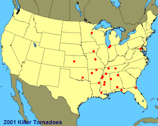
This page documents notable tornadoes and tornado outbreaks worldwide in 2001. Strong and destructive tornadoes form most frequently in the United States, Bangladesh, and Eastern India, but they can occur almost anywhere under the right conditions. Tornadoes also develop occasionally in southern Canada during the Northern Hemisphere's summer and somewhat regularly at other times of the year across Europe, Asia, and Australia. Tornadic events are often accompanied with other forms of severe weather, including strong thunderstorms, strong winds, and hail.

<span class="mw-page-title-main">Tornado outbreak of February 28 – March 2, 2007</span> Windstorm in the southern United States from Feb 28 - March 2, 2007

The tornado outbreak of February 28 – March 2, 2007 was a deadly tornado outbreak across the southern United States that began in Kansas on February 28, 2007. The severe weather spread eastward on March 1 and left a deadly mark across the southern US, particularly in Alabama and Georgia. Twenty deaths were reported; one in Missouri, nine in Georgia, and 10 in Alabama. Scattered severe weather was also reported in North Carolina on March 2, producing the final tornado of the outbreak before the storms moved offshore into the Atlantic Ocean.

<span class="mw-page-title-main">Tornado outbreak of March 28–31, 2007</span> Severe storms in the central United States

The tornado outbreak of March 28–31, 2007, also known as the Late-March 2007 tornado outbreak, was a tornado outbreak that took place across the central United States. It developed in the High Plains from South Dakota to central Texas on March 28, 2007, which produced most of the tornadoes. Several more tornadoes were reported the next three days before the system weakened on March 31. It affected western Nebraska, western Kansas, extreme eastern Colorado, and much of Oklahoma, and Texas. It was the second major outbreak of 2007, four weeks after an outbreak farther east. The outbreak produced 80 confirmed tornadoes, with five deaths and extensive damage being reported. In addition to the tornadoes, widespread hail as large as softballs and destructive straight-line winds as strong as 90 mph (140 km/h) were reported.

<span class="mw-page-title-main">October 2009 North American storm complex</span>

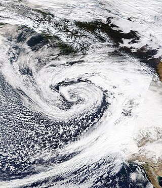
The October 2009 North American storm complex was a powerful extratropical cyclone that was associated with the remnants of Typhoon Melor, which brought extreme amounts of rainfall to California. The system started out as a weak area of low pressure, that formed in the northern Gulf of Alaska on October 7. Late on October 11, the system quickly absorbed Melor's remnant moisture, which resulted in the system strengthening significantly offshore, before moving southeastward to impact the West Coast of the United States, beginning very early on October 13. Around the same time, an atmospheric river opened up, channeling large amounts of moisture into the storm, resulting in heavy rainfall across California and other parts of the Western United States. The storm caused at least $8.861 million in damages across the West Coast of the United States.

<span class="mw-page-title-main">January 2010 North American winter storms</span>

The January 2010 North American winter storms were a group of seven powerful winter storms that affected Canada and the Contiguous United States, particularly California. The storms developed from the combination of a strong El Niño episode, a powerful jet stream, and an atmospheric river that opened from the West Pacific Ocean into the Western Seaboard. The storms shattered multiple records across the Western United States, with the sixth storm breaking records for the lowest recorded air pressure in multiple parts of California, which was also the most powerful winter storm to strike the Southwestern United States in 140 years. The fourth, fifth, and sixth storms spawned several tornadoes across California, with at least 6 tornadoes confirmed in California ; the storms also spawned multiple waterspouts off the coast of California. The storms dumped record amounts of rain and snow in the Western United States, and also brought hurricane-force winds to the U.S. West Coast, causing flooding and wind damage, as well as triggering blackouts across California that cut the power to more than 1.3 million customers. The storms killed at least 10 people, and caused more than $66.879 million in damages.

<span class="mw-page-title-main">March 2014 North American winter storm</span> Winter storm in 2014

The March 2014 North American winter storm, also unofficially referred to as Winter Storm Titan, was an extremely powerful winter storm that affected much of the United States and portions of Canada. It was one of the most severe winter storms of the 2013–14 North American winter storm season, storm affecting most of the Western Seaboard, and various parts of the Eastern United States, bringing damaging winds, flash floods, and blizzard and icy conditions.

<span class="mw-page-title-main">December 2014 North American storm complex</span> Winter storm

The December 2014 North American storm complex was a powerful winter storm that impacted the West Coast of the United States, beginning on the night of December 10, 2014, resulting in snow, wind, and flood watches. Fueled by the Pineapple Express, an atmospheric river originating in the tropical waters of the Pacific Ocean adjacent to the Hawaiian Islands, the storm was the strongest to affect California since January 2010. The system was also the single most intense storm to impact the West Coast, in terms of minimum low pressure, since a powerful winter storm in January 2008. The National Weather Service classified the storm as a significant threat, and issued 15 warnings and advisories, including a Blizzard Warning for the Northern Sierra Nevada.

<span class="mw-page-title-main">2010–11 North American winter</span>

The 2010–11 North American winter was influenced by an ongoing La Niña, seeing winter storms and very cold temperatures affect a large portion of the Continental United States, even as far south as the Texas Panhandle. Notable events included a major blizzard that struck the Northeastern United States in late December with up to 2 feet (24 in) of snowfall and a significant tornado outbreak on New Year's Eve in the Southern United States. By far the most notable event was a historic blizzard that impacted areas from Oklahoma to Michigan in early February. The blizzard broke numerous snowfall records, and was one of the few winter storms to rank as a Category 5 on the Regional Snowfall Index. In addition, Oklahoma set a statewide low temperature record in February.

<span class="mw-page-title-main">November 2020 North American storm complex</span>

The November 2020 North American storm complex was a major early-season snowstorm that impacted most of the Ohio Valley from November 30–December 2 with heavy snow, gusty winds, and near-whiteout conditions. The system originated from a weak gulf low off the coast of Texas on November 29, which began to move northeastward onto land the next day. It then began to strengthen, as well as slowing its movement down, resulting in heavy, wind-driven snow for prolonged periods of time in the Ohio Valley. It also triggered a major lake-effect snow event from December 1–2 as the system stalled over Lake Ontario, resulting in additional heavy snowfall. The storm system was also responsible for a severe thunderstorm outbreak in the Southeast and Mid-Atlantic regions, causing 22 severe thunderstorms and 5 tornadoes. In total, the system is estimated to have caused at least $100 million in damages. It was unofficially named Winter Storm Dane by The Weather Channel.

<span class="mw-page-title-main">March 2021 North American blizzard</span> Winter storm and tornado outbreak in 2021

The March 2021 North American blizzard was a record-breaking blizzard in the Rocky Mountains and a significant snowstorm in the Upper Midwest that occurred in mid-March 2021. It brought Cheyenne, Wyoming their largest two-day snowfall on record, and Denver, Colorado their second-largest March snowfall on record. The storm originated from an extratropical cyclone in the northern Pacific Ocean in early March, arriving on the west coast of the United States by March 10. The storm moved into the Rocky Mountains on Saturday, March 13, dumping up to 2–3 feet (24–36 in) of snow in some areas. It was unofficially given the name Winter Storm Xylia.

<span class="mw-page-title-main">October 2021 Northeast Pacific bomb cyclone</span> North American bomb cyclone in 2021

An extremely powerful extratropical bomb cyclone began in late October 2021 in the Northeast Pacific and struck the Western United States and Western Canada. The storm was the third and the most powerful cyclone in a series of powerful storms that struck the region within a week. The cyclone tapped into a large atmospheric river and underwent explosive intensification, becoming a bomb cyclone on October 24. The bomb cyclone had a minimum central pressure of 942 millibars (27.8 inHg) at its peak, making it the most powerful cyclone recorded in the Northeast Pacific. The system had severe impacts across Western North America, before dissipating on October 26. The storm shattered multiple pressure records across parts of the Pacific Northwest. Additionally, the bomb cyclone was the most powerful storm on record to strike the region, in terms of minimum central pressure. The bomb cyclone brought powerful gale-force winds and flooding to portions of Western North America. At its height, the storm cut the power to over 370,500 customers across the Western U.S. and British Columbia. The storm killed at least two people; damage from the storm was estimated at several hundred million dollars. The bomb cyclone was compared to the Columbus Day Storm of 1962, in terms of ferocity.

References

  1. 1 2 "(weather map)". met.fu-berlin.de.
  2. 1 2 "WPC Surface Analysis Archive".
  3. 1 2 "AccuWeather.com - Weather Blogs - Weather News".
  4. 1 2 3 "Storm Summary Number 03 for Heavy Rainfall associated with Potential Tropical Cyclone One". College Park MD: NWS Weather Prediction Center. June 4, 2022.
  5. 1 2 "AccuWeather.com - Weather Blogs - Weather News".
  6. "Storm Events". Storm Event Database. National Climatic Data Center (NCDC). January 10, 2008. Archived from the original on September 15, 1999. Retrieved June 19, 2008.
  7. 1 2 McKinley, Jesse (January 5, 2008). "Ferocious Storm Punishes Northern California". The New York Times. Retrieved May 5, 2010.
  8. "WPC Surface Analysis Archive".
  9. "WPC Surface Analysis Archive".
  10. "WPC Surface Analysis Archive".
  11. "WPC Surface Analysis Archive".
  12. "WPC Surface Analysis Archive".
  13. "WPC Surface Analysis Archive".
  14. "AccuWeather.com - Weather Blogs - Weather News".
  15. Rong-Gong Lin II; Paloma Esqivel; Hector Becerra (2008-01-05). "Storm now has its eye on the Southland". Los Angeles Times. Retrieved 2021-11-06.
  16. "WPC Surface Analysis Archive".
  17. "WPC Surface Analysis Archive".
  18. "WPC Surface Analysis Archive".
  19. "WPC Surface Analysis Archive".
  20. "WPC Surface Analysis Archive".
  21. "WPC Surface Analysis Archive".
  22. "WPC Surface Analysis Archive".
  23. "WPC Surface Analysis Archive".
  24. "WPC Surface Analysis Archive".
  25. "WPC Surface Analysis Archive".
  26. "WPC Surface Analysis Archive".
  27. "WPC Surface Analysis Archive".
  28. "WPC Surface Analysis Archive".
  29. "(weather map)". met.fu-berlin.de.
  30. "(weather map)". met.fu-berlin.de.
  31. "(weather map)". met.fu-berlin.de.
  32. "(weather map)". met.fu-berlin.de.
  33. abc7news.com: 1/05/08
  34. "Three Dead From West Coast Storms". CBS News. January 6, 2008.
  35. "ABC News: Cold Waters Recede in Flooded Nev. Town". ABC News .
  36. http://www.mercurynews.com/breakingnews/ci_7884040 [ dead link ]
  37. Tourtellotte, Bob (January 5, 2008). "UPDATE 1-California braces for second round of storms". Reuters.
  38. "New storms threaten West Coast". CBC News. January 6, 2008. Archived from the original on February 27, 2021.
  39. "Wells Fargo creates bank account to help Fernley recover". Archived from the original on January 14, 2008.
  40. "Gibbons declares state of emergency in Fernley flood". Archived from the original on January 14, 2008.
  41. "Storms kill three in western US". BBC News. January 6, 2008. Retrieved May 5, 2010.
  42. "Man killed, seven injured on icy mountain highway". Archived from the original on January 8, 2008.
  43. "Homes remain flooded after levee break - CNN.com".
  44. Residents of Flooded Nevada Town Return
  45. "6 snowmobilers rescued from remote outpost". NBC News.
  46. "7 Suffer Carbon Monoxide Poisoning After Storm -KCRA Sacramento". Archived from the original on May 19, 2011.
  47. "Missing Snowmobilers Rescued In Colorado - KOAT Albuquerque". Archived from the original on July 13, 2011.
  48. "Storm Bearing Down On Bay To Pack Weaker Punch - KRXI Reno". Archived from the original on July 11, 2011.
  49. "Six missing snowmobilers safe after weekend lost in snow - CNN.com".
  50. "Storm Events Database - Event Details | National Centers for Environmental Information". www.ncdc.noaa.gov.
  51. "Storm Events Database - Event Details | National Centers for Environmental Information". www.ncdc.noaa.gov.
  52. "Storm Events Database - Event Details | National Centers for Environmental Information". www.ncdc.noaa.gov.
  53. "Storm Events Database - Event Details | National Centers for Environmental Information". www.ncdc.noaa.gov.
  54. "Storm Events Database - Event Details | National Centers for Environmental Information". www.ncdc.noaa.gov.
  55. "Storm Events Database - Event Details | National Centers for Environmental Information". www.ncdc.noaa.gov.
  56. "Storm Events Database - Event Details | National Centers for Environmental Information". www.ncdc.noaa.gov.
  57. "Storm Events Database - Event Details | National Centers for Environmental Information".
  58. "Storm Events Database - Event Details | National Centers for Environmental Information".
  59. "Storm Events Database - Event Details | National Centers for Environmental Information".
  60. "Storm Events Database - Event Details | National Centers for Environmental Information".
  61. "Storm Events Database - Event Details | National Centers for Environmental Information".
  62. "Storm Events Database - Event Details | National Centers for Environmental Information".
  63. "Storm Events Database - Event Details | National Centers for Environmental Information".
  64. "Storm Events Database - Event Details | National Centers for Environmental Information".
  65. "Storm Events Database - Event Details | National Centers for Environmental Information".
  66. "Storm Events Database - Event Details | National Centers for Environmental Information".
  67. "Storm Events Database - Event Details | National Centers for Environmental Information".
  68. "Storm Events Database - Event Details | National Centers for Environmental Information".
  69. "NWS SGF Jan 08 2008 Tornadoes". Archived from the original on 2008-01-17.
  70. "Storm Events Database - Event Details | National Centers for Environmental Information".
  71. "Tornadoes of January 7, 2008". Crh.noaa.gov. Retrieved January 1, 2012.
  72. "Storm Events Database - Event Details | National Centers for Environmental Information".
  73. "Storm Events Database - Event Details | National Centers for Environmental Information".
  74. "Storm Events Database - Event Details | National Centers for Environmental Information".
  75. "January 7, 2008 Tornado". Archived from the original on 2008-01-21.
  76. "Storm Events Database - Event Details | National Centers for Environmental Information".
  77. "Storm Events Database - Event Details | National Centers for Environmental Information".
  78. "Storm Events Database - Event Details | National Centers for Environmental Information".
  79. "Storm Events Database - Event Details | National Centers for Environmental Information".
  80. "Storm Events Database - Event Details | National Centers for Environmental Information".
  81. "Storm Events Database - Event Details | National Centers for Environmental Information".
  82. "Storm Events Database - Event Details | National Centers for Environmental Information".
  83. 1 2 "Storm Events Database - Event Details | National Centers for Environmental Information".
  84. "Storm Events Database - Event Details | National Centers for Environmental Information".
  85. "Storm Events Database - Event Details | National Centers for Environmental Information".
  86. "Storm Events Database - Event Details | National Centers for Environmental Information".
  87. "Storm Events Database - Event Details | National Centers for Environmental Information".
  88. "Storm Events Database - Event Details | National Centers for Environmental Information".
  89. "Storm Events Database - Event Details | National Centers for Environmental Information".
  90. "Storm Events Database - Event Details | National Centers for Environmental Information".
  91. "Storm Events Database - Event Details | National Centers for Environmental Information".
  92. "Storm Events Database - Event Details | National Centers for Environmental Information".
  93. "Storm Events Database - Event Details | National Centers for Environmental Information".
  94. "Storm Events Database - Event Details | National Centers for Environmental Information".
  95. "Storm Events Database - Event Details | National Centers for Environmental Information".
  96. "Storm Events Database - Event Details | National Centers for Environmental Information".
  97. "Storm Events Database - Event Details | National Centers for Environmental Information".
  98. "Storm Events Database - Event Details | National Centers for Environmental Information".
  99. "Storm Events Database - Event Details | National Centers for Environmental Information".
  100. "Storm Events Database - Event Details | National Centers for Environmental Information".
  101. "Storm Events Database - Event Details | National Centers for Environmental Information".
  102. "Storm Events Database - Event Details | National Centers for Environmental Information".
  103. "Storm Events Database - Event Details | National Centers for Environmental Information".
  104. "Storm Events Database - Event Details | National Centers for Environmental Information".
  105. "Storm Events Database - Event Details | National Centers for Environmental Information".
  106. "Storm Events Database - Event Details | National Centers for Environmental Information".

37°N122°W / 37°N 122°W / 37; -122