Pineville, Missouri

Last updated

Pineville, Missouri
OLD MCDONALD COUNTY COURTHOUSE, PINEVILLE, MO.jpg
Nickname: 
The River City [1]
McDonald County Missouri Incorporated and Unincorporated areas Pineville Highlighted.svg
Location within McDonald County and the state of Missouri
Coordinates: 36°34′20″N94°23′03″W / 36.57222°N 94.38417°W / 36.57222; -94.38417 [2]
Country United States
State Missouri
County McDonald
Area
[3]
  Total3.29 sq mi (8.53 km2)
  Land3.29 sq mi (8.53 km2)
  Water0.00 sq mi (0.00 km2)
Elevation
[2]
1,070 ft (330 m)
Population
 (2020) [4]
  Total802
  Density243.62/sq mi (94.06/km2)
Time zone UTC-6 (Central (CST))
  Summer (DST) UTC-5 (CDT)
ZIP code
64856
Area code 417
FIPS code 29-57818 [5]
GNIS feature ID2396212 [2]
Website pinevillemo.us

Pineville is a city in and the county seat of McDonald County, Missouri, United States. [6] The population was 802 at the 2020 census. [4]

Contents

History

Pineville was originally named "Maryville", and was laid out under the latter name in 1847. [7] [8] The name was changed to "Pineville" in 1849 since another community already had the name of Maryville. [9] Some say that Pineville was named for a grove of pine trees at the original town site, while others believe the name is a transfer from Pineville, Kentucky. [7]

On August 17, 1897, Pineville was the site of a bank robbery which was one of the few at that time that involved a woman as an active participant in the actual robbery. Cora Hubbard, who was 20 at the time, John Sheets, a 23-year-old from Missouri, and 31-year-old Albert Whitfield "Whit" Tennison robbed the McDonald County Bank, stealing a total of $589.23 (equivalent to $21,580in 2023). All three were soon captured and imprisoned.

Jesse James (1939) was filmed almost entirely in Pineville. The sequel Belle Starr (1941) was also filmed here. [10]

The county's historic Old McDonald County Courthouse, which is operated as a museum by the McDonald County Historical Society, was named to the National Register of Historic Places on May 1, 2012. [11]

Geography

Pineville is in south-central McDonald County, located just north of the confluence of Big and Little Sugar Creeks, which forms the Elk River. Noel lies 8 miles (13 km) to the southwest, downstream on the Elk River, and Anderson lies about 6 miles (10 km) to the northwest, along U.S. Route 71. [12] Interstate 49 passes west of the center of town, with access from exits 5 and 7. I-49 leads north 20 miles (32 km) to Neosho and south 24 miles (39 km) to Bentonville, Arkansas.

According to the U.S. Census Bureau, Pineville has a total area of 3.29 square miles (8.52 km2), all of it recorded as land. [3] Big Sugar Creek forms part of the eastern border of the city, and the Elk River flows west across the city from its source at the confluence of Big and Little Sugar Creeks.

Demographics

Historical population
CensusPop.Note
1880 147
1890 19230.6%
1920 359
1930 42217.5%
1940 52424.2%
1950 464−11.5%
1960 454−2.2%
1970 444−2.2%
1980 50413.5%
1990 58015.1%
2000 76832.4%
2010 7913.0%
2020 8021.4%
U.S. Decennial Census [13]

2010 census

As of the census [14] of 2010, there were 791 people, 287 households, and 185 families living in the city. The population density was 254.3 inhabitants per square mile (98.2/km2). There were 357 housing units at an average density of 114.8 per square mile (44.3/km2). The racial makeup of the city was 92.0% White, 0.1% African American, 4.7% Native American, 1.5% from other races, and 1.6% from two or more races. Hispanic or Latino of any race were 3.2% of the population.

There were 287 households, of which 36.2% had children under the age of 18 living with them, 44.3% were married couples living together, 17.8% had a female householder with no husband present, 2.4% had a male householder with no wife present, and 35.5% were non-families. 31.4% of all households were made up of individuals, and 12.2% had someone living alone who was 65 years of age or older. The average household size was 2.63 and the average family size was 3.31.

The median age in the city was 33.8 years. 29.7% of residents were under the age of 18; 10.3% were between the ages of 18 and 24; 24.3% were from 25 to 44; 22.5% were from 45 to 64; and 13.1% were 65 years of age or older. The gender makeup of the city was 45.6% male and 54.4% female.

2000 census

As of the census [5] of 2000, there were 768 people, 309 households, and 207 families living in the town. The population density was 1,094.0 inhabitants per square mile (422.4/km2). There were 350 housing units at an average density of 498.6 per square mile (192.5/km2). The racial makeup of the town was 95.70% White, 2.60% Native American, 0.39% from other races, and 1.30% from two or more races. Hispanic or Latino of any race were 1.04% of the population.

There were 309 households, out of which 33.7% had children under the age of 18 living with them, 48.9% were married couples living together, 14.9% had a female householder with no husband present, and 33.0% were non-families. 29.1% of all households were made up of individuals, and 13.9% had someone living alone who was 65 years of age or older. The average household size was 2.41 and the average family size was 2.98.

In the town the population was spread out, with 27.3% under the age of 18, 9.4% from 18 to 24, 28.8% from 25 to 44, 19.4% from 45 to 64, and 15.1% who were 65 years of age or older. The median age was 34 years. For every 100 females, there were 86.9 males. For every 100 females age 18 and over, there were 83.6 males.

The median income for a household in the town was $24,886, and the median income for a family was $34,583. Males had a median income of $23,182 versus $20,515 for females. The per capita income for the town was $13,414. About 19.3% of families and 23.2% of the population were below the poverty line, including 30.8% of those under age 18 and 20.4% of those age 65 or over.

Education

Public education in Pineville is administered by McDonald County R-1 School District. [15]

Pineville has a public library, the McDonald County Library. [16]

Related Research Articles

<span class="mw-page-title-main">McDonald County, Missouri</span> County in Missouri, United States

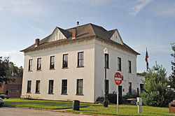
McDonald County is a county located in the southwestern corner of the U.S. state of Missouri. As of the 2020 census, the population was 23,303. Its county seat is Pineville. The county was organized in 1849 and named for Sergeant Alexander McDonald, a soldier in the American Revolutionary War. The county has three sites on the National Register of Historic Places, including the Old McDonald County Courthouse and the Powell Bridge.

<span class="mw-page-title-main">Elk Falls, Kansas</span> City in Elk County, Kansas

Elk Falls is a city in Elk County, Kansas, United States, along the Elk River. As of the 2020 census, the population of the city was 113.

<span class="mw-page-title-main">Harrisonville, Missouri</span> City in Missouri, United States

Harrisonville is a city in Cass County, Missouri, United States. The population was 10,121 at the 2020 census. It is the county seat of Cass County. It is part of the Kansas City metropolitan area.

<span class="mw-page-title-main">Ozark, Missouri</span> City in Missouri, United States

Ozark is a city in and the county seat of Christian County, Missouri. Its population was 21,284 as of the 2020 census. Ozark is also the third largest city in the Springfield, Missouri Metropolitan Area, and is centered along a business loop of U.S. Route 65, where it intersects with Missouri Route 14.

<span class="mw-page-title-main">Clinton, Missouri</span> City in Missouri, United States

Clinton is a city in Henry County, Missouri, United States. The population was 9,174 at the 2020 census. It is the county seat of Henry County.

<span class="mw-page-title-main">Linneus, Missouri</span> City in Missouri, United States

Linneus is a small city in Linn County, Missouri, United States. The population was 281 at the 2020 census. It is the county seat of Linn County.

<span class="mw-page-title-main">Anderson, Missouri</span> City in Missouri, United States

Anderson is a city in McDonald County, Missouri, United States. The population was 1,981 at the 2020 census.

<span class="mw-page-title-main">Goodman, Missouri</span> City in Missouri, United States

Goodman is a city in McDonald County, Missouri, United States. The population was 1,202 at the 2020 census.

<span class="mw-page-title-main">Lanagan, Missouri</span> City in Missouri, United States

Lanagan is a city in McDonald County, Missouri, United States. It is near Truitt's Cave. The population was 373 at the 2020 census, down from 419 in 2010.

<span class="mw-page-title-main">Noel, Missouri</span> City in Missouri, United States

Noel is a city in McDonald County, Missouri, United States, along the Elk River. The population was 2,124 as of the 2020 census, up from 1,832 in 2010. The city is in the southwest corner of Missouri, just north of the Arkansas border.

<span class="mw-page-title-main">Southwest City, Missouri</span> City in Missouri, United States

Southwest City is a city in McDonald County, Missouri, United States. The population was 922 at the 2020 census. It is located in the southwestern corner of the state of Missouri.

<span class="mw-page-title-main">Madison, Missouri</span> City in Missouri, United States

Madison is a city in Monroe County, Missouri, United States. The population was 515 at the 2020 census.

<span class="mw-page-title-main">McKittrick, Missouri</span> City in Missouri, United States

McKittrick is a city in Montgomery County, Missouri, United States. The population was 77 at the 2020 census.

<span class="mw-page-title-main">Shelbyville, Missouri</span> City in Missouri, United States

Shelbyville is a city in Shelby County, Missouri, United States. The population was 518 at the 2020 census. It is the county seat of Shelby County.

<span class="mw-page-title-main">Highland Township, Elk County, Pennsylvania</span> Township in Pennsylvania, United States

Highland Township is a township in Elk County, Pennsylvania, United States. The population was 398 at the 2020 census, down from 492 in 2010.

<span class="mw-page-title-main">Elk Point, South Dakota</span> City in South Dakota, United States

Elk Point is a city in and the county seat of Union County, South Dakota, United States. The population was 2,149 as of the 2020 census.

<span class="mw-page-title-main">Elk Garden, West Virginia</span> Town in West Virginia, United States

Elk Garden is a town in Mineral County, West Virginia, United States. It is part of the 'Cumberland, MD-WV Metropolitan Statistical Area'. The population was 211 at the 2020 census. Elk Garden High School was consolidated into Keyser High School in 1997. However the Primary School is still in session, offering classes from Pre-Kindergarten through the fifth grade. The school mascot is the Elk Garden Stags. Elk Garden was incorporated in 1890 by the Mineral County Circuit Court. It is named for an elk lick near the original town site.

<span class="mw-page-title-main">Oceana, West Virginia</span> Town in West Virginia, United States

Oceana is a town in Wyoming County, West Virginia. The population was 1,462 at the time of the 2020 census. Oceana is the oldest city in Wyoming County and was the county seat until 1907.

<span class="mw-page-title-main">Pineville, West Virginia</span> Town in West Virginia, United States

Pineville is a town in and the county seat of Wyoming County, West Virginia, United States, situated along the Guyandotte River. The population was 648 at the 2020 census.

Ginger Blue is an incorporated village in McDonald County, Missouri, United States. The population was 37 at the 2020 census, down from 61 in 2010.

References

  1. "Pineville, Missouri, Official Home Page". City of Pineville. Retrieved March 28, 2024.
  2. 1 2 3 U.S. Geological Survey Geographic Names Information System: Pineville, Missouri
  3. 1 2 "2023 U.S. Gazetteer Files: Missouri". United States Census Bureau. Retrieved March 28, 2024.
  4. 1 2 "P1. Race – Pineville city, Missouri: 2020 DEC Redistricting Data (PL 94-171)". U.S. Census Bureau. Retrieved March 28, 2024.
  5. 1 2 "U.S. Census website". United States Census Bureau . Retrieved January 31, 2008.
  6. "Find a County". National Association of Counties. Archived from the original on May 31, 2011. Retrieved June 7, 2011.
  7. 1 2 "McDonald County Place Names, 1928–1945". The State Historical Society of Missouri. Archived from the original on June 24, 2016. Retrieved November 4, 2016.
  8. Glines, Karen (August 2017). Painting Missouri: The Counties en Plein Air. ISBN   9781591522010.
  9. "Post Offices". Jim Forte Postal History. Retrieved November 3, 2016.
  10. Maddrey, Joseph (2016). The Quick, the Dead and the Revived: The Many Lives of the Western Film. McFarland. Page 182. ISBN   9781476625492.
  11. "National Register of Historic Places Listings". Weekly List of Actions Taken on Properties: 4/30/12 through 5/04/12. National Park Service. May 11, 2012.
  12. Missouri Atlas & Gazetteer, DeLorme, 1998, First edition, p. 60, ISBN   0-89933-224-2
  13. "Census of Population and Housing". Census.gov. Retrieved June 4, 2015.
  14. "U.S. Census website". United States Census Bureau . Retrieved July 8, 2012.
  15. "Homepage". Mcdonald County R-I School District. Retrieved June 4, 2019.
  16. "Missouri Public Libraries". PublicLibraries.com. Archived from the original on June 10, 2017. Retrieved June 2, 2019.