Hillsboro, Missouri

Last updated

Hillsboro, Missouri
Jefferson County MO courthouse-20140524-015.jpg
Nickname: 
The Boro
Jefferson County Missouri Incorporated and Unincorporated areas Hillsboro Highlighted.svg
Location of Hillsboro, Missouri
Coordinates: 38°13′59″N90°34′02″W / 38.23306°N 90.56722°W / 38.23306; -90.56722
Country United States
State Missouri
County Jefferson
Incorporated 1839
Government
  MayorBuddy Russell [1]
Area
[2]
  Total3.84 sq mi (9.95 km2)
  Land3.84 sq mi (9.95 km2)
  Water0.00 sq mi (0.00 km2)
Elevation
[3]
771 ft (235 m)
Population
 (2020)
  Total3,473
  Density903.96/sq mi (348.98/km2)
Time zone UTC-6 (Central (CST))
  Summer (DST) UTC-5 (CDT)
ZIP code
63050
Area code 636
FIPS code 29-32248 [4]
GNIS feature ID2394388 [3]
Website hillsboromo.org

Hillsboro is a city and county seat of Jefferson County, Missouri, United States. The population was 3,473 at the 2020 census, up from 2,821 in 2010. [5]

Contents

History

Hillsboro in 1933 Missouri - Big Spring State Part through Hillsboro - NARA - 23941771 (cropped).jpg
Hillsboro in 1933

Hillsboro was originally called Monticello, and under the latter name was platted in 1839, and named after Monticello, home of President Thomas Jefferson. [6] The name Monticello was afterwards changed because the U.S. postal authorities refused to accept that name, there being another post office in the state with a similar name. The present name Hillsboro is the English equivalent of the Italian name Monticello. [7] A post office has been in operation at Hillsboro since 1838. [8]

The Thomas C. Fletcher House and Sandy Creek Covered Bridge are listed on the National Register of Historic Places. [9]

Geography

According to the United States Census Bureau, the city has a total area of 3.65 square miles (9.45 km2), all land. [10]

Demographics

Historical population
CensusPop.Note
1890 264
1900 254−3.8%
1910 2612.8%
1920 205−21.5%
1930 23313.7%
1940 2569.9%
1950 39052.3%
1960 45717.2%
1970 83181.8%
1980 1,50881.5%
1990 1,6257.8%
2000 1,6753.1%
2010 2,82168.4%
2020 3,47323.1%
U.S. Decennial Census [11]

2010 census

As of the census [12] of 2010, there were 2,821 people, 900 households, and 623 families living in the city. The population density was 772.9 inhabitants per square mile (298.4/km2). There were 957 housing units at an average density of 262.2 per square mile (101.2/km2). The racial makeup of the city was 94.5% White, 2.8% African American, 0.4% Native American, 0.5% Asian, 0.5% from other races, and 1.3% from two or more races. Hispanic or Latino of any race were 2.0% of the population.

There were 900 households, of which 44.2% had children under the age of 18 living with them, 48.3% were married couples living together, 15.9% had a female householder with no husband present, 5.0% had a male householder with no wife present, and 30.8% were non-families. 25.1% of all households were made up of individuals, and 8.2% had someone living alone who was 65 years of age or older. The average household size was 2.69 and the average family size was 3.23.

The median age in the city was 29.2 years. 27.9% of residents were under the age of 18; 13.8% were between the ages of 18 and 24; 31.2% were from 25 to 44; 19% were from 45 to 64; and 8.2% were 65 years of age or older. The gender makeup of the city was 52.0% male and 48.0% female.

2000 census

As of the census [4] of 2000, there were 1,675 people, 581 households, and 395 families living in the city. The population density was 701.4 inhabitants per square mile (270.8/km2). There were 620 housing units at an average density of 259.6 per square mile (100.2/km2). The racial makeup of the city was 95.46% White, 2.03% African American, 0.36% Native American, 0.66% Asian, 0.60% from other races, and 0.90% from two or more races. Hispanic or Latino of any race were 2.15% of the population.

There were 581 households, out of which 35.1% had children under the age of 18 living with them, 47.7% were married couples living together, 16.5% had a female householder with no husband present, and 32.0% were non-families. 26.2% of all households were made up of individuals, and 8.3% had someone living alone who was 65 years of age or older. The average household size was 2.60 and the average family size was 3.09.

In the city, the population was spread out, with 27.7% under the age of 18, 13.7% from 18 to 24, 30.8% from 25 to 44, 19.9% from 45 to 64, and 7.9% who were 65 years of age or older. The median age was 31 years. For every 100 females, there were 107.0 males. For every 100 females age 18 and over, there were 106.0 males.

The median income for a household in the city was $36,850, and the median income for a family was $44,000. Males had a median income of $30,880 versus $24,408 for females. The per capita income for the city was $15,585. About 9.7% of families and 14.3% of the population were below the poverty line, including 19.6% of those under age 18 and 9.4% of those age 65 or over.

Education

The main campus of Jefferson College is located in Hillsboro. Jefferson College is a two-year institution that serves the broader Jefferson County area.

Hillsboro R-3 School District is the local school district. The city has 1 high school, Hillsboro High School.

See also

Related Research Articles

<span class="mw-page-title-main">Schram City, Illinois</span> Village in Illinois, United States

Schram City is a village in Montgomery County, Illinois, United States. The population was 563 at the 2020 census.

<span class="mw-page-title-main">Monticello, Indiana</span> City in Indiana, United States

Monticello is a city in and the county seat of White County, Indiana, United States. The population was 5,508 at the 2020 census. Monticello is known as a tourist destination in north-central Indiana and is home to the Indiana Beach amusement park on Lake Shafer, and Lake Freeman.

<span class="mw-page-title-main">St. Martins, Missouri</span> City in Missouri, United States

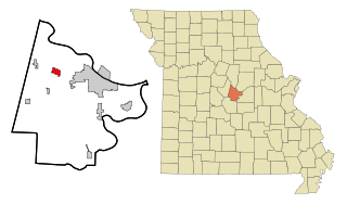
St. Martins or Saint Martins is a city in Cole County, Missouri, United States. The population was 1,191 at the 2020 census. It is part of the Jefferson City, Missouri Metropolitan Statistical Area.

<span class="mw-page-title-main">Byrnes Mill, Missouri</span> City in Missouri, United States

Byrnes Mill is a city in northern Jefferson County, Missouri, United States. The population was 3,173 at the 2020 census.

<span class="mw-page-title-main">Cedar Hill Lakes, Missouri</span> Village in Missouri, United States

Cedar Hill Lakes is a village in Jefferson County, Missouri, United States. The population was 203 at the 2020 census.

<span class="mw-page-title-main">High Ridge, Missouri</span> Census-designated place in Missouri, United States

High Ridge is an unincorporated community and census-designated place (CDP) in Jefferson County, Missouri, United States. The population was 4,305 at the 2010 census. At 927 feet (283 m) above sea level, High Ridge is the second-highest point in Jefferson County, second only to Sun Ridge, north of Hillsboro, according to data from the House Springs/Hillsboro 7.5 minute topographic quadrangles. The Beaumont Scout Reservation, a property of the Greater St. Louis Area Council, Boy Scouts of America, is 4 miles (6 km) north of High Ridge.

<span class="mw-page-title-main">Pevely, Missouri</span> City in Missouri, United States

Pevely is a city in Jefferson County, Missouri, United States, and is also a suburb of St. Louis. The population was 6,107, at the 2020 United States Census.

<span class="mw-page-title-main">Monticello, Missouri</span> Village in Missouri, United States

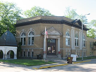
Monticello is a rural village in, and county seat of, Lewis County, Missouri, United States, along the North Fabius River. The population was 104 at the 2020 census, and according to this census, Monticello is the county seat with the smallest population in the State of Missouri. The town is named in honor of President Thomas Jefferson's estate in Virginia. Monticello is part of the Quincy, IL–MO Micropolitan Statistical Area.

<span class="mw-page-title-main">Westphalia, Missouri</span> City in Missouri, United States

Westphalia is a city in Osage County, Missouri, United States. The population was 378 at the 2020 census. It is part of the Jefferson City, Missouri Metropolitan Statistical Area.

<span class="mw-page-title-main">Bowling Green, Missouri</span> City in Missouri, United States

Bowling Green is a city and the county seat of in Pike County, Missouri, United States. The population was 5,334 at the 2010 census.

<span class="mw-page-title-main">Tracy, Missouri</span> City in Missouri, United States

Tracy is a city in Platte County, Missouri within the United States, located along the Platte River. The population was 269 at the 2020 census. The city is part of the Kansas City metropolitan area.

<span class="mw-page-title-main">Miami, Missouri</span> City in Missouri, United States

Miami is a city in Saline County, Missouri, United States. The population was 175 at the 2010 census.

<span class="mw-page-title-main">Crystal Lake Park, Missouri</span> City in Missouri, United States

Crystal Lake Park is a Missouri Class 4 city in St. Louis County, Missouri, United States. The population was 508 at the 2020 census.

<span class="mw-page-title-main">Manchester, Missouri</span> City in Missouri, United States

Manchester is a city in St. Louis County, Missouri, United States. The population was 18,333 at the 2020 census.

<span class="mw-page-title-main">Winchester, Missouri</span> City in Missouri, United States

Winchester is a city in St. Louis County, Missouri, United States. The population was 1,447 at the 2020 census.

<span class="mw-page-title-main">Schell City, Missouri</span> City in Missouri, United States

Schell City is a city in northeast Vernon County, Missouri, United States. The population was 249 at the 2010 census.

<span class="mw-page-title-main">Lake Mykee Town, Missouri</span> Village in Missouri, United States

Lake Mykee Town was a village in Callaway County, Missouri, United States whose government was dissolved and land area annexed into Holts Summit, Missouri. Because of this, Lake Mykee no longer exists and the former village is now referred to as Holts Summit. The population was 350 at the 2010 census. It is part of the Jefferson City Metropolitan Statistical Area.

<span class="mw-page-title-main">Lake Monticello, Virginia</span> Census-designated place in Virginia, United States

Lake Monticello, a private gated community, is a census-designated place (CDP) in Fluvanna County, Virginia, United States. The population was 10,126 at the 2020 census. The community is centered on a lake of the same name, which is formed by a dam on a short tributary of the nearby Rivanna River. Lake Monticello is part of the Charlottesville Metropolitan Statistical Area. Lake Monticello was developed in the 1960s as a summer vacation home community but quickly evolved into a bedroom community of Charlottesville, and to a smaller extent of Richmond. It also has a sizable retirement age population.

<span class="mw-page-title-main">Hillsboro (town), Wisconsin</span> Town in Wisconsin, United States

Hillsboro is a town in Vernon County, Wisconsin, United States. The population was 766 at the 2000 census. The City of Hillsboro is located within the town. The unincorporated community of Trippville is also located in the town.

<span class="mw-page-title-main">Dardenne Prairie, Missouri</span> Town in Missouri, United States

Dardenne Prairie is a city in St. Charles County, Missouri, United States. The population was 12,743 at the 2020 census.

References

  1. City of Hillsboro.
  2. "ArcGIS REST Services Directory". United States Census Bureau. Retrieved August 28, 2022.
  3. 1 2 U.S. Geological Survey Geographic Names Information System: Hillsboro, Missouri
  4. 1 2 "U.S. Census website". United States Census Bureau . Retrieved January 31, 2008.
  5. "Find a County". National Association of Counties. Archived from the original on May 31, 2011. Retrieved June 7, 2011.
  6. "Jefferson County Place Names, 1928–1945 (archived)". The State Historical Society of Missouri. Archived from the original on June 24, 2016. Retrieved October 19, 2016.{{cite web}}: CS1 maint: bot: original URL status unknown (link)
  7. "Disappearing Missouri Names". The Kansas City Star. March 19, 1911. p. 15. Retrieved August 15, 2014 via Newspapers.com. Open Access logo PLoS transparent.svg
  8. "Post Offices". Jim Forte Postal History. Retrieved October 19, 2016.
  9. "National Register Information System". National Register of Historic Places . National Park Service. July 9, 2010.
  10. "US Gazetteer files 2010". United States Census Bureau. Archived from the original on January 12, 2012. Retrieved July 8, 2012.
  11. "Census of Population and Housing". Census.gov. Retrieved June 4, 2015.
  12. "U.S. Census website". United States Census Bureau . Retrieved July 8, 2012.
  13. Former Autovon Switching Centers.