Kahoka, Missouri

Last updated
Kahoka, Missouri
Clark County Missouri Incorporated and Unincorporated areas Kahoka Highlighted.svg
Location within Clark County and Missouri
Coordinates: 40°25′26″N91°43′07″W / 40.42389°N 91.71861°W / 40.42389; -91.71861 Coordinates: 40°25′26″N91°43′07″W / 40.42389°N 91.71861°W / 40.42389; -91.71861
Country United States
State Missouri
County Clark
Area
[1]
  Total1.62 sq mi (4.19 km2)
  Land1.59 sq mi (4.11 km2)
  Water0.03 sq mi (0.08 km2)
Elevation
[2]
696 ft (212 m)
Population
 (2020)
  Total1,961
  Density1,236.44/sq mi (477.46/km2)
Time zone UTC-6 (Central (CST))
  Summer (DST) UTC-5 (CDT)
ZIP code
63445
Area code 660
FIPS code 29-37790 [3]
GNIS feature ID2395484 [2]

Kahoka is a city in and the county seat of Clark County, in the northeast tip of Missouri, United States. [4] As of the 2020 census, its population was 1,961. [5]

Contents

History

Kahoka was platted in 1858. [6] The city is named for the historic Cahokia tribe of the Illiniwek or Illinois Confederacy, which occupied territory on both sides of the Mississippi River in this area at the time of European encounter. [7]

The Clark County Courthouse, Col. Hiram M. Hiller House, and Montgomery Opera House are listed on the National Register of Historic Places. [8]

Geography

Kahoka is located at the intersection of U.S. Route 136 and Missouri Route 81. Wayland is approximately seven miles to the east and Luray is 8.5 miles to the west. The Fox River flows past about one mile to the northeast. [9]

According to the United States Census Bureau, the city has a total area of 1.60 square miles (4.14 km2), of which 1.57 square miles (4.07 km2) is land and 0.03 square miles (0.08 km2) is water. [10]

Demographics

Historical population
CensusPop.Note
1880 704
1890 1,425102.4%
1900 1,81827.6%
1910 1,758−3.3%
1920 1,624−7.6%
1930 1,507−7.2%
1940 1,78118.2%
1950 1,8473.7%
1960 2,16016.9%
1970 2,2072.2%
1980 2,101−4.8%
1990 2,1954.5%
2000 2,2412.1%
2010 2,078−7.3%
2020 1,961−5.6%
Decennial US Census

Kahoka is part of the Fort Madison Keokuk, IA-MO Micropolitan Statistical Area.

2010 census

As of the census [11] of 2010, there were 2,078 people, 883 households, and 521 families living in the city. The population density was 1,323.6 inhabitants per square mile (511.0/km2). There were 1,001 housing units at an average density of 637.6 per square mile (246.2/km2). The racial makeup of the city was 98.5% White, 0.2% African American, 0.1% Native American, 0.2% Asian, 0.1% from other races, and 0.8% from two or more races. Hispanic or Latino of any race were 0.7% of the population.

There were 883 households, of which 30.2% had children under the age of 18 living with them, 43.0% were married couples living together, 10.5% had a female householder with no husband present, 5.4% had a male householder with no wife present, and 41.0% were non-families. 36.0% of all households were made up of individuals, and 18.6% had someone living alone who was 65 years of age or older. The average household size was 2.25 and the average family size was 2.92.

The median age in the city was 39.9 years. 23.7% of residents were under the age of 18; 8.5% were between the ages of 18 and 24; 23.1% were from 25 to 44; 23.6% were from 45 to 64; and 21% were 65 years of age or older. The gender makeup of the city was 46.5% male and 53.5% female.

2000 census

As of the census [3] of 2000, there were 2,241 people, 921 households, and 562 families living in the city. The population density was 1,464.0 inhabitants per square mile (565.3/km2). There were 1,014 housing units at an average density of 662.4 per square mile (255.8/km2). The racial makeup of the city was 98.48% White, 0.09% African American, 0.40% Native American, 0.002% Dutch, 0.04% Asian, 0.13% from other races, and 0.85% from two or more races. Hispanic or Latino of any race were 0.80% of the population.

There were 921 households, out of which 30.5% had children under the age of 18 living with them, 47.2% were married couples living together, 9.6% had a female householder with no husband present, and 38.9% were non-families. 35.4% of all households were made up of individuals, and 20.5% had someone living alone who was 65 years of age or older. The average household size was 2.31 and the average family size was 3.01.

In the city, the population was spread out, with 25.3% under the age of 18, 8.3% from 18 to 24, 24.1% from 25 to 44, 19.9% from 45 to 64, and 22.5% who were 65 years of age or older. The median age was 39 years. For every 100 females, there were 86.1 males. For every 100 females age 18 and over, there were 78.2 males.

The median income for a household in the city was $24,384, and the median income for a family was $30,192. Males had a median income of $24,313 versus $16,563 for females. The per capita income for the city was $14,928. About 15.4% of families and 17.4% of the population were below the poverty line, including 21.1% of those under age 18 and 18.8% of those age 65 or over.

Education

Public education in Kahoka is administered by Clark County R-I School District, which operates two elementary schools, one middle school, and Clark County High School. [12]

Kahoka has a public library, the H.E. Sever Memorial Branch Library. [13]

Notable people

See also

Related Research Articles

<span class="mw-page-title-main">Clark County, Missouri</span> County in Missouri, United States

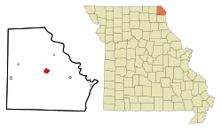
Clark County is a county located in the U.S. state of Missouri. As of the 2020 census, its population was 6,634. Its county seat is Kahoka. The county was organized December 16, 1836 and named for William Clark, leader of the Lewis and Clark Expedition and later Governor of Missouri Territory.

<span class="mw-page-title-main">Savannah, Missouri</span> City in Missouri, United States

Savannah is a city and county seat of Andrew County, Missouri, United States. The population was 5,069 at the 2020 census.

<span class="mw-page-title-main">Sturgeon, Missouri</span> City in Missouri, United States

Sturgeon is a city in Boone County, Missouri, United States. It is part of the Columbia, Missouri Metropolitan Statistical Area. The population was 872 at the 2010 census.

<span class="mw-page-title-main">Lewis and Clark Village, Missouri</span> Village in Missouri, United States

Lewis and Clark Village is a village in Buchanan County, Missouri, United States. The population was 132 at the 2010 census. It is part of the St. Joseph, MO–KS Metropolitan Statistical Area.

<span class="mw-page-title-main">East Lynne, Missouri</span> City in Missouri, United States

East Lynne is a city in eastern Cass County, Missouri The population was 303 at the 2010 census. It is part of the Kansas City metropolitan area within the United States.

<span class="mw-page-title-main">Alexandria, Missouri</span> City in Missouri, United States

Alexandria is a city in eastern Clark County, Missouri, United States. As of the 2020 census, its population was 105.

<span class="mw-page-title-main">Luray, Missouri</span> Village in Missouri, United States

Luray is a village in Clark County, Missouri, United States. As of the 2020 census, its population was 73. It is part of the Fort Madison–Keokuk, IA-MO Micropolitan Statistical Area.

<span class="mw-page-title-main">Wayland, Missouri</span> City in Missouri, United States

Wayland is a city in Clark County, Missouri, United States. As of the 2020 census, its population was 408. It is part of the Fort Madison–Keokuk, IA-MO Micropolitan Statistical Area.

<span class="mw-page-title-main">Wyaconda, Missouri</span> City in Missouri, United States

Wyaconda is a city in Clark County, Missouri, United States. As of the 2020 census, its population was 214. The city was organized in 1888 and is named after a Siouan name for God or the Great Spirit. The first land purchased from the Santa Fe and Land Co. was in 1888.

<span class="mw-page-title-main">Pilot Grove, Missouri</span> City in Missouri, United States

Pilot Grove is a city in the Pilot Grove Township in northern Cooper County, Missouri, United States. The population was 768 at the 2010 census.

<span class="mw-page-title-main">Clarksdale, Missouri</span> City in Missouri, United States

Clarksdale is a city in southwest DeKalb County, Missouri, United States, located along the Little Third Fork of the Platte River. The population was 245 at the 2020 census. It is part of the St. Joseph, MO–KS Metropolitan Statistical Area.

<span class="mw-page-title-main">Clarkton, Missouri</span> City in Missouri, United States

Clarkton is a city in Dunklin County, Missouri, United States. The population was 1,288 at the 2010 census. Clarkton is the oldest city in Dunklin County.

<span class="mw-page-title-main">Fayette, Missouri</span> City in Missouri, United States

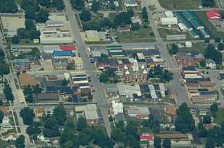
Fayette is a city in and the county seat of Howard County, Missouri, United States. It is part of the Columbia, Missouri Metropolitan Statistical Area. The city's population was 2,803 at the 2020 census.

<span class="mw-page-title-main">Linneus, Missouri</span> City in Missouri, United States

Linneus is a small city in Linn County, Missouri, United States. The population was 281 at the 2020 census. It is the county seat of Linn County.

<span class="mw-page-title-main">Nelson, Missouri</span> City in Missouri, United States

Nelson is a city in Saline County, Missouri, United States. The population was 152 at the 2020 census.

<span class="mw-page-title-main">Oakland, Missouri</span> City in Missouri, United States

Oakland is a city in St. Louis County, Missouri, United States. The population was 1,381 at the 2010 census.

<span class="mw-page-title-main">Walker, Missouri</span> City in Missouri, United States

Walker is a city in Vernon County, Missouri, United States. The population was 270 at the 2010 census.

<span class="mw-page-title-main">Montgomery City, Missouri</span> City in Missouri, United States

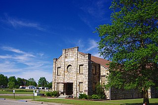
Montgomery City is a city in and the county seat of Montgomery County, Missouri, United States. The population was 2,811 at the 2020 census.

<span class="mw-page-title-main">Clark, Missouri</span> City in Missouri, United States

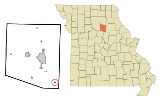
Clark is a city in Randolph County, Missouri, United States. The population was 298 at the 2010 census.

<span class="mw-page-title-main">Scott City, Missouri</span> City in Missouri, United States

Scott City is a city in Cape Girardeau and Scott counties in the U.S. state of Missouri. The population was 4,346 at the 2020 census. The Scott County portion of Scott City is part of the Sikeston Micropolitan Statistical Area, while the Cape Girardeau County portion is part of the Cape Girardeau–Jackson, MO-IL Metropolitan Statistical Area.

References

  1. "ArcGIS REST Services Directory". United States Census Bureau. Retrieved August 28, 2022.
  2. 1 2 U.S. Geological Survey Geographic Names Information System: Kahoka, Missouri
  3. 1 2 "U.S. Census website". United States Census Bureau . Retrieved 2008-01-31.
  4. "Find a County". National Association of Counties. Archived from the original on 2011-05-31. Retrieved 2011-06-07.
  5. "2020: DEC Redistricting Data (PL 94-171)". United States Census Bureau . Retrieved November 17, 2021.
  6. "Clark County Place Names, 1928–1945 (archived)". The State Historical Society of Missouri. Archived from the original on 24 June 2016. Retrieved 18 September 2016.{{cite web}}: CS1 maint: bot: original URL status unknown (link)
  7. Eaton, David Wolfe (1916). How Missouri Counties, Towns and Streams Were Named. The State Historical Society of Missouri. pp. 275–276.
  8. "National Register Information System". National Register of Historic Places . National Park Service. July 9, 2010.
  9. Missouri Atlas & Gazetteer, DeLorme, First edition, 1998, p. 16 ISBN   0899332242
  10. "US Gazetteer files 2010". United States Census Bureau. Archived from the original on 2012-07-02. Retrieved 2012-07-08.
  11. "U.S. Census website". United States Census Bureau . Retrieved 2012-07-08.
  12. "Clark County R-I School District". Great Schools. Retrieved 2 June 2019.
  13. "Missouri Public Libraries". PublicLibraries.com. Archived from the original on 10 June 2017. Retrieved 2 June 2019.