Alton, Missouri

Last updated

Alton, Missouri
Oregon County MO Courthouse 20151021-020.jpg
Oregon County Courthouse
Oregon County Missouri Incorporated and Unincorporated areas Alton Highlighted.svg
Location of Alton, Missouri
Coordinates: 36°41′24″N91°23′41″W / 36.69000°N 91.39472°W / 36.69000; -91.39472
Country United States
State Missouri
County Oregon
Incorporated1929 [1]
Area
[2]
  Total1.58 sq mi (4.10 km2)
  Land1.57 sq mi (4.06 km2)
  Water0.01 sq mi (0.04 km2)
Elevation
[3]
748 ft (228 m)
Population
 (2020)
  Total707
  Density450.61/sq mi (174.01/km2)
Time zone UTC-6 (Central (CST))
  Summer (DST) UTC-5 (CDT)
ZIP code
65606
Area code 417
FIPS code 29-00964 [4]
GNIS feature ID2393937 [3]

Alton is a city and the county seat [5] of Oregon County, Missouri, United States. The population was 707 at the 2020 census. [6]

Contents

History

Alton was platted in 1859. [7] The city was named after Alton, Illinois. [8] [9] A post office has been in operation in Alton since 1860. [10] Alton was incorporated as a city in 1929. [1]

Greer Mill was listed on the National Register of Historic Places in 2005. [11]

Geography

According to the United States Census Bureau, the city has a total area of 1.59 square miles (4.12 km2), of which 1.57 square miles (4.07 km2) is land and 0.02 square miles (0.05 km2) is water. [12]

Climate

Climate data for Alton, Missouri (1991–2020 normals, extremes 1962–2014)
MonthJanFebMarAprMayJunJulAugSepOctNovDecYear
Record high °F (°C)76
(24)
82
(28)
90
(32)
92
(33)
95
(35)
101
(38)
107
(42)
109
(43)
103
(39)
96
(36)
85
(29)
76
(24)
109
(43)
Mean daily maximum °F (°C)43.8
(6.6)
48.6
(9.2)
58.3
(14.6)
68.7
(20.4)
75.8
(24.3)
85.0
(29.4)
88.3
(31.3)
88.1
(31.2)
80.8
(27.1)
70.2
(21.2)
56.7
(13.7)
45.9
(7.7)
67.5
(19.7)
Daily mean °F (°C)33.1
(0.6)
36.9
(2.7)
46.0
(7.8)
56.0
(13.3)
64.5
(18.1)
73.4
(23.0)
77.1
(25.1)
76.1
(24.5)
68.1
(20.1)
56.5
(13.6)
45.0
(7.2)
35.8
(2.1)
55.7
(13.2)
Mean daily minimum °F (°C)22.4
(−5.3)
25.1
(−3.8)
33.7
(0.9)
43.2
(6.2)
53.1
(11.7)
61.7
(16.5)
65.9
(18.8)
64.2
(17.9)
55.4
(13.0)
42.8
(6.0)
33.2
(0.7)
25.7
(−3.5)
43.9
(6.6)
Record low °F (°C)−18
(−28)
−10
(−23)
1
(−17)
15
(−9)
28
(−2)
40
(4)
46
(8)
45
(7)
31
(−1)
16
(−9)
1
(−17)
−6
(−21)
−18
(−28)
Average precipitation inches (mm)2.96
(75)
3.39
(86)
4.45
(113)
4.66
(118)
5.57
(141)
3.31
(84)
4.01
(102)
3.92
(100)
3.46
(88)
3.77
(96)
4.44
(113)
3.29
(84)
47.23
(1,200)
Average snowfall inches (cm)1.7
(4.3)
0.8
(2.0)
0.9
(2.3)
0.0
(0.0)
0.0
(0.0)
0.0
(0.0)
0.0
(0.0)
0.0
(0.0)
0.0
(0.0)
0.0
(0.0)
0.0
(0.0)
0.8
(2.0)
4.2
(11)
Average precipitation days (≥ 0.01 in)6.46.89.17.99.96.87.27.15.46.37.46.686.9
Average snowy days (≥ 0.1 in)1.11.00.30.00.00.00.00.00.00.00.00.42.8
Source: NOAA [13] [14]

Demographics

Historical population
CensusPop.Note
1870 76
1880 12767.1%
1930 439
1940 57631.2%
1950 571−0.9%
1960 67718.6%
1970 7155.6%
1980 7210.8%
1990 692−4.0%
2000 668−3.5%
2010 87130.4%
2020 707−18.8%
U.S. Decennial Census [15]

2010 census

As of the census [16] of 2010, there were 871 people, 352 households, and 213 families living in the city. The population density was 554.8 inhabitants per square mile (214.2/km2). There were 406 housing units at an average density of 258.6 per square mile (99.8/km2). The racial makeup of the city was 95.64% White, 0.46% Black or African American, 0.69% Native American, and 3.21% from two or more races. Hispanic or Latino people of any race were 1.38% of the population.

There were 352 households, of which 32.7% had children under the age of 18 living with them, 39.8% were married couples living together, 16.2% had a female householder with no husband present, 4.5% had a male householder with no wife present, and 39.5% were non-families. 35.5% of all households were made up of individuals, and 23% had someone living alone who was 65 years of age or older. The average household size was 2.34 and the average family size was 2.99.

The median age in the city was 39.2 years. 28.7% of residents were under the age of 18; 6.3% were between the ages of 18 and 24; 22.2% were from 25 to 44; 16.9% were from 45 to 64; and 25.6% were 65 years of age or older. The gender makeup of the city was 45.7% male and 54.3% female.

2000 census

As of the census [4] of 2000, there were 668 people, 321 households, and 188 families living in the city. The population density was 797.2 inhabitants per square mile (307.8/km2). There were 364 housing units at an average density of 434.4 per square mile (167.7/km2). The racial makeup of the city was 97.01% White, 0.30% African American, 1.95% Native American, and 0.75% from two or more races. Hispanic or Latino people of any race were 0.60% of the population.

There were 321 households, out of which 24.0% had children under the age of 18 living with them, 45.2% were married couples living together, 11.2% had a female householder with no husband present, and 41.4% were non-families. 38.6% of all households were made up of individuals, and 26.8% had someone living alone who was 65 years of age or older. The average household size was 2.07 and the average family size was 2.70.

In the city, the population was spread out, with 20.1% under the age of 18, 7.3% from 18 to 24, 23.2% from 25 to 44, 22.3% from 45 to 64, and 27.1% who were 65 years of age or older. The median age was 45 years. For every 100 females there were 82.5 males. For every 100 females age 18 and over, there were 78.6 males.

The median income for a household in the city was $16,667, and the median income for a family was $21,667. Males had a median income of $21,184 versus $13,929 for females. The per capita income for the city was $10,071. About 18.0% of families and 27.4% of the population were below the poverty line, including 28.1% of those under age 18 and 33.6% of those age 65 or over.

Education

Alton R-IV School District operates Alton Elementary School and Alton High School. [17]

The town has a lending library, the Alton Branch Library. [18]

See also

Related Research Articles

<span class="mw-page-title-main">Wood River, Illinois</span> City in Illinois, United States

Wood River is a city in Madison County, Illinois. The population was 10,464 as of the 2020 census.

Alton is a town in Penobscot County, Maine, United States. It is part of the Bangor Metropolitan Statistical Area. The population was 829 at the 2020 census. The community is named after an Alton in England.

<span class="mw-page-title-main">New Bloomfield, Missouri</span> City in Missouri, United States

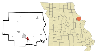
New Bloomfield is a city in Cedar Township, Callaway County, Missouri, United States. The population was 669 at the 2010 census. It is part of the Jefferson City Metropolitan Statistical Area.

<span class="mw-page-title-main">Bogard, Missouri</span> City in Missouri, United States

Bogard is a city in Carroll County, Missouri, United States. The population was 167 at the 2020 census.

<span class="mw-page-title-main">Calhoun, Missouri</span> City in Missouri, United States

Calhoun is a city in Henry County, Missouri, United States. The population was 469 at the 2010 census.

<span class="mw-page-title-main">Urich, Missouri</span> City in Missouri, United States

Urich is a city in Henry County, Missouri, United States. The population was 505 at the 2010 census.

<span class="mw-page-title-main">Craig, Missouri</span> City in Missouri, United States

Craig is a city in Holt County, Missouri, United States. The population was 105 at the 2020 census.

<span class="mw-page-title-main">Oronogo, Missouri</span> City in Missouri, United States

Oronogo is a city in Jasper County, Missouri, United States. The population was 2,558 at the 2020 census. It is part of the Joplin, Missouri Metropolitan Statistical Area.

<span class="mw-page-title-main">Foley, Missouri</span> City in Missouri, United States

Foley is a city in Lincoln County, Missouri, United States. The population was 161 at the 2010 census.

<span class="mw-page-title-main">Tallapoosa, Missouri</span> City in Missouri, United States

Tallapoosa is a city in New Madrid County, Missouri, United States. The population was 78 at the 2020 census.

<span class="mw-page-title-main">Green Ridge, Missouri</span> City in Missouri, United States

Green Ridge is a city located along Route 127 in Pettis County, Missouri, United States. The population was 476 at the 2010 census.

<span class="mw-page-title-main">Benton, Missouri</span> City in Missouri, United States

Benton is a city in Scott County, Missouri, United States. The population was 863 at the 2010 census. It is the county seat of Scott County.

<span class="mw-page-title-main">West Alton, Missouri</span> City in Missouri, United States

West Alton is a city in St. Charles County, Missouri, United States. The population was 359 at the 2020 census. It is located at the tip of the peninsula formed by the confluence of the Missouri and Mississippi Rivers and is directly across Alton, Illinois.

<span class="mw-page-title-main">Jennings, Missouri</span> City in Missouri, United States

Jennings is a city in St. Louis County, Missouri, United States. Per the 2020 census, the population was 12,895.

<span class="mw-page-title-main">Lakeshire, Missouri</span> City in Missouri, United States

Lakeshire is a city in St. Louis County, Missouri, United States. The population was 1,432 at the 2010 census.

<span class="mw-page-title-main">Oakland, Missouri</span> City in Missouri, United States

Oakland is a city in St. Louis County, Missouri, United States. The population was 1,381 at the 2010 census.

<span class="mw-page-title-main">Velda City, Missouri</span> City in Missouri, United States

Velda City is a city in St. Louis County, Missouri, United States. The population was 1,420 at the 2010 census.

<span class="mw-page-title-main">Moscow Mills, Missouri</span> City in Missouri, United States

Moscow Mills is a city in Lincoln County, Missouri, United States. The population was 2,509 at the 2010 census.

<span class="mw-page-title-main">Moline Acres, Missouri</span> City in Missouri, United States

Moline Acres is a city in St. Louis County, Missouri, United States. The population was 2,442 at the 2010 census.

<span class="mw-page-title-main">Blackburn, Missouri</span> City in Missouri, United States

Blackburn is a city in Lafayette and Saline counties in the U.S. state of Missouri and is part of the Kansas City metropolitan area. The population was 224 at the 2020 census.

References

  1. 1 2 Hellmann, Paul T. (February 14, 2006). Historical Gazetteer of the United States. Routledge. p. 609. ISBN   1-135-94859-3.
  2. "ArcGIS REST Services Directory". United States Census Bureau. Retrieved August 28, 2022.
  3. 1 2 U.S. Geological Survey Geographic Names Information System: Alton, Missouri
  4. 1 2 "U.S. Census website". United States Census Bureau . Retrieved January 31, 2008.
  5. "Find a County". National Association of Counties. Archived from the original on May 31, 2011. Retrieved June 7, 2011.
  6. "Explore Census Data". data.census.gov. Retrieved December 26, 2021.
  7. "Oregon County Place Names, 1928–1945". The State Historical Society of Missouri. Archived from the original on June 24, 2016. Retrieved November 24, 2016.
  8. Earngey, Bill (1995). Missouri Roadsides: The Traveler's Companion. University of Missouri Press. p. 5. ISBN   9780826210210.
  9. Eaton, David Wolfe (1917). How Missouri Counties, Towns and Streams Were Named. The State Historical Society of Missouri. p. 337.
  10. "Oregon County". Jim Forte Postal History. Retrieved April 4, 2015.
  11. "National Register Information System". National Register of Historic Places . National Park Service. July 9, 2010.
  12. "US Gazetteer files 2010". United States Census Bureau. Archived from the original on January 25, 2012. Retrieved July 8, 2012.
  13. "NowData – NOAA Online Weather Data". National Oceanic and Atmospheric Administration. Retrieved August 3, 2021.
  14. "Station: Alton, MO". U.S. Climate Normals 2020: U.S. Monthly Climate Normals (1991-2020). National Oceanic and Atmospheric Administration. Retrieved August 3, 2021.
  15. "Census of Population and Housing". Census.gov. Retrieved June 4, 2015.
  16. "U.S. Census website". United States Census Bureau . Retrieved July 8, 2012.
  17. "Alton R-IV School District". GreatSchools. Retrieved March 17, 2018.
  18. "Missouri Public Libraries". PublicLibraries.com. Archived from the original on June 10, 2017. Retrieved March 17, 2018.