Princeton, Missouri

Last updated

Princeton, Missouri
Princeton-downtown.jpg
Mercer County Courthouse and downtown
Mercer County Missouri Incorporated and Unincorporated areas Princeton Highlighted.svg
Location in Mercer County and the state of Missouri
Coordinates: 40°23′48″N93°35′18″W / 40.39667°N 93.58833°W / 40.39667; -93.58833
Country United States
State Missouri
County Mercer
Area
[1]
  Total1.60 sq mi (4.15 km2)
  Land1.59 sq mi (4.12 km2)
  Water0.01 sq mi (0.03 km2)
Elevation
[2]
899 ft (274 m)
Population
 (2020) [3]
  Total1,007
  Density633.73/sq mi (244.71/km2)
Time zone UTC-6 (Central (CST))
  Summer (DST) UTC-5 (CDT)
ZIP code
64673
Area code 660
FIPS code 29-59942 [4]
GNIS feature ID2396281 [2]
Website www.cityofprincetonmo.com

Princeton is the county seat and largest city of Mercer County, Missouri, United States. The population was 1,007 at the 2020 census, [5] down from the 2010 census, which counted 1,166 people. Princeton was the birthplace of the famous frontierswoman Calamity Jane.

Contents

History

Princeton historical marker Princeton Missouri sign.jpg
Princeton historical marker

Princeton was platted in 1846. [6] The city was named in commemoration of the Battle of Princeton in the American Revolutionary War. [7] A post office has been in operation at Princeton since 1846. [8]

The Herbert Cain and Corah Brantley Casteel House and Leo Ellis Post No. 22, American Legion Building are listed on the National Register of Historic Places.

Geography

Princeton is in northern Missouri, in the center of Mercer County. U.S. Route 65 passes through the east side of the city, leading south 24 miles (39 km) to Trenton and north 13 miles (21 km) to Lineville, Iowa. U.S. Route 136 passes through the north side of Princeton, briefly joining US 65 but leading east 33 miles (53 km) to Unionville and southwest 28 miles (45 km) to Bethany.

According to the U.S. Census Bureau, Princeton has a total area of 1.60 square miles (4.14 km2), of which 1.59 square miles (4.12 km2) are land and 0.01 square miles (0.03 km2), or 0.81%, are water. [1] The Weldon River touches the western border of the city, and its tributary Wildcat Creek touches the eastern border. The city is built on a ridge separating the two water bodies. Via the Weldon River, Princeton is part of the Thompson River/Grand River watershed flowing south to the Missouri River.

Climate

Princeton has a hot-summer humid continental climate (Köppen Dfa). Summers are often hot and humid whereas winters are dry with days averaging above freezing in all months, which means sparse snow cover in spite of the cold overnight temperatures. Being far inland, the temperatures amplitude is large with an all-time range of 139 °F (77 °C).

Climate data for Princeton, Missouri (1991–2020 normals, extremes 1893–present)
MonthJanFebMarAprMayJunJulAugSepOctNovDecYear
Record high °F (°C)72
(22)
77
(25)
88
(31)
96
(36)
97
(36)
106
(41)
111
(44)
110
(43)
102
(39)
95
(35)
84
(29)
70
(21)
111
(44)
Mean maximum °F (°C)56
(13)
61
(16)
75
(24)
82
(28)
87
(31)
92
(33)
96
(36)
95
(35)
91
(33)
84
(29)
71
(22)
60
(16)
97
(36)
Mean daily maximum °F (°C)33.6
(0.9)
38.8
(3.8)
51.3
(10.7)
62.7
(17.1)
72.0
(22.2)
81.4
(27.4)
85.8
(29.9)
84.2
(29.0)
77.2
(25.1)
65.2
(18.4)
50.6
(10.3)
38.1
(3.4)
61.7
(16.5)
Daily mean °F (°C)24.2
(−4.3)
28.5
(−1.9)
40.1
(4.5)
50.9
(10.5)
61.2
(16.2)
71.1
(21.7)
75.6
(24.2)
73.6
(23.1)
65.3
(18.5)
53.6
(12.0)
40.2
(4.6)
29.1
(−1.6)
51.1
(10.6)
Mean daily minimum °F (°C)14.7
(−9.6)
18.2
(−7.7)
28.9
(−1.7)
39.2
(4.0)
50.4
(10.2)
60.9
(16.1)
65.3
(18.5)
63.0
(17.2)
53.5
(11.9)
41.9
(5.5)
29.9
(−1.2)
20.1
(−6.6)
40.5
(4.7)
Mean minimum °F (°C)−5
(−21)
−1
(−18)
10
(−12)
24
(−4)
37
(3)
49
(9)
56
(13)
53
(12)
39
(4)
27
(−3)
14
(−10)
0
(−18)
−10
(−23)
Record low °F (°C)−26
(−32)
−28
(−33)
−25
(−32)
8
(−13)
28
(−2)
37
(3)
42
(6)
35
(2)
25
(−4)
13
(−11)
−12
(−24)
−25
(−32)
−28
(−33)
Average precipitation inches (mm)1.10
(28)
1.23
(31)
2.23
(57)
4.24
(108)
5.05
(128)
5.60
(142)
3.86
(98)
4.25
(108)
3.81
(97)
3.29
(84)
1.90
(48)
1.42
(36)
37.98
(965)
Average extreme snow depth inches (cm)3
(7.6)
3
(7.6)
1
(2.5)
0
(0)
0
(0)
0
(0)
0
(0)
0
(0)
0
(0)
0
(0)
0
(0)
1
(2.5)
4
(10)
Average precipitation days (≥ 0.01 in)5.85.87.39.812.310.58.58.67.47.96.15.195.1
Source: NOAA [9] [10]

Demographics

Historical population
CensusPop.Note
1860 249
1870 38956.2%
1880 1,240218.8%
1890 1,41013.7%
1900 1,57511.7%
1910 1,385−12.1%
1920 1,57613.8%
1930 1,509−4.3%
1940 1,5845.0%
1950 1,506−4.9%
1960 1,443−4.2%
1970 1,328−8.0%
1980 1,264−4.8%
1990 1,021−19.2%
2000 1,0472.5%
2010 1,16611.4%
2020 1,007−13.6%
U.S. Decennial Census [11]

2010 census

As of the census [12] of 2010, there were 1,166 people, 525 households, and 282 families living in the city. The population density was 733.3 inhabitants per square mile (283.1/km2). There were 632 housing units at an average density of 397.5 per square mile (153.5/km2). The racial makeup of the city was 98.9% White, 0.3% African American, 0.2% Native American, 0.2% Asian, 0.3% from other races, and 0.2% from two or more races. Hispanic or Latino of any race were 0.8% of the population.

There were 525 households, of which 28.2% had children under the age of 18 living with them, 40.2% were married couples living together, 10.1% had a female householder with no husband present, 3.4% had a male householder with no wife present, and 46.3% were non-families. 41.9% of all households were made up of individuals, and 22.4% had someone living alone who was 65 years of age or older. The average household size was 2.12 and the average family size was 2.91.

The median age in the city was 40.3 years. 24.4% of residents were under the age of 18; 6.6% were between the ages of 18 and 24; 23.4% were from 25 to 44; 20.8% were from 45 to 64; and 24.6% were 65 years of age or older. The gender makeup of the city was 47.7% male and 52.3% female.

2000 census

As of the census [4] of 2000, there were 1,047 people, 499 households, and 271 families living in the city. The population density was 660.5 inhabitants per square mile (255.0/km2). There were 566 housing units at an average density of 357.0 per square mile (137.8/km2). The racial makeup of the city was 98.85% White, 0.10% African American, 0.67% Native American, and 0.38% from two or more races. Hispanic or Latino of any race were 0.29% of the population.

There were 499 households, out of which 26.1% had children under the age of 18 living with them, 41.1% were married couples living together, 8.8% had a female householder with no husband present, and 45.5% were non-families. 42.9% of all households were made up of individuals, and 30.1% had someone living alone who was 65 years of age or older. The average household size was 2.05 and the average family size was 2.79.

In the city, the population was spread out, with 22.7% under the age of 18, 7.3% from 18 to 24, 21.7% from 25 to 44, 19.9% from 45 to 64, and 28.5% who were 65 years of age or older. The median age was 44 years. For every 100 females there were 77.8 males. For every 100 females age 18 and over, there were 75.1 males.

The median income for a household in the city was $27,059, and the median income for a family was $39,125. Males had a median income of $29,583 versus $19,327 for females. The per capita income for the city was $15,485. About 14.3% of families and 17.3% of the population were below the poverty line, including 22.9% of those under age 18 and 15.8% of those age 65 or over.

Education

Princeton is home to the Princeton R-V School District which consists of an elementary school (K-6), a junior high school (grades 7–8) and Princeton High School (grades 9-12).

Princeton has a public library, the Mercer County Library. [13]

Notable people

Related Research Articles

<span class="mw-page-title-main">Mercer County, Missouri</span> County in Missouri, United States

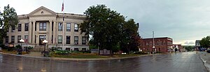
Mercer County is a county located in the northwestern portion of the U.S. state of Missouri. As of the 2020 census, the population was 3,538, making it the second-least populous county in Missouri. Its county seat is Princeton. The county was organized February 14, 1845 and named for General John F. Mercer of the Revolutionary War.

<span class="mw-page-title-main">Pleasanton, Iowa</span> City in Iowa, United States

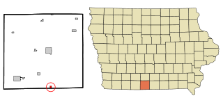
Pleasanton is a city in Decatur County, Iowa, United States. The population was 32 at the time of the 2020 census.

<span class="mw-page-title-main">El Dorado Springs, Missouri</span> City in Missouri, United States

El Dorado Springs is the largest city in Cedar County, Missouri, United States. The population was 3,493 at the 2020 census.

<span class="mw-page-title-main">Cainsville, Missouri</span> City in Missouri, United States

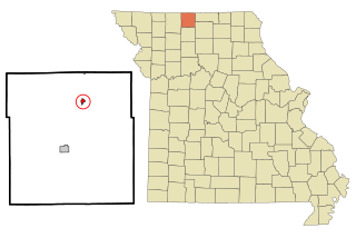
Cainsville is a city in eastern Harrison County, Missouri, United States. The population was 283 at the 2020 census.

<span class="mw-page-title-main">Raytown, Missouri</span> City in Missouri, United States

Raytown is a city in Jackson County, Missouri, United States, and is a suburb of Kansas City. The population was at 30,012 in 2020 census. The current mayor of Raytown is Michael McDonough. It is part of the Kansas City metropolitan area.

<span class="mw-page-title-main">Chula, Missouri</span> City in Missouri, United States

Chula is a city in Livingston County, Missouri, United States. The population was 195 at the 2020 census.

<span class="mw-page-title-main">Mercer, Missouri</span> City in Missouri, United States

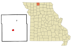
Mercer is a city in Mercer County, Missouri, United States. The population was 263 at the 2020 census.

<span class="mw-page-title-main">South Lineville, Missouri</span> Village in Missouri, United States

South Lineville is a village in Mercer County, Missouri, United States. The population was 13 at the 2020 census, a decline of fifteen people from the 2010 census.

<span class="mw-page-title-main">Maplewood, Missouri</span> City in Missouri, United States

Maplewood is an inner-ring suburb of St. Louis, located in St. Louis County, Missouri, United States.

<span class="mw-page-title-main">Velda City, Missouri</span> City in Missouri, United States

Velda City is a city in St. Louis County, Missouri, United States. The population was 1,420 at the 2010 census.

<span class="mw-page-title-main">Mount Moriah, Missouri</span> Village in Missouri, United States

Mount Moriah is a village in eastern Harrison County, Missouri, United States. The population at the 2020 census was 75.

<span class="mw-page-title-main">Moline Acres, Missouri</span> City in Missouri, United States

Moline Acres is a city in St. Louis County, Missouri, United States. The population was 2,442 at the 2010 census.

<span class="mw-page-title-main">Mercer, North Dakota</span> City in North Dakota, United States

Mercer is a city in McLean County, North Dakota, United States. The population was 88 at the 2020 census.

<span class="mw-page-title-main">Pick City, North Dakota</span> City in North Dakota, United States

Pick City is a town in Mercer County, North Dakota, United States. The population was 123 at the 2020 census. Pick City was founded in 1946 and named after Lewis A. Pick, director of the Missouri River office of the United States Army Corps of Engineers. It overlooks the Garrison Dam.

<span class="mw-page-title-main">Stanton, North Dakota</span> City in North Dakota, United States

Stanton is a city in Mercer County, North Dakota, United States. It is the county seat of Mercer County. The population was 368 at the 2020 census. Stanton was founded in 1883 and became the county seat when Mercer County organized in 1884.

<span class="mw-page-title-main">Toby Township, Pennsylvania</span> Township in Pennsylvania, United States

Toby Township is a township in Clarion County, Pennsylvania, United States. The population was 984 at the 2020 census, a decrease from the figure of 991 in 2010 census, which was, in turn, a decline from 1,166 at the 2000 census.

<span class="mw-page-title-main">Buffalo Township, Union County, Pennsylvania</span> Township in Pennsylvania, United States

Buffalo Township is a township in Union County, Pennsylvania, United States. The population was 3,536 at the 2020 census.

<span class="mw-page-title-main">Garretson, South Dakota</span> City in South Dakota, United States

Garretson is a city in Minnehaha County, South Dakota, United States. The city had a population of 1,228 at the 2020 census.

<span class="mw-page-title-main">Windsor Heights, West Virginia</span> Village in West Virginia, United States

Windsor Heights is a village in Brooke County, West Virginia, United States. It is part of the Wheeling, West Virginia Metropolitan Statistical Area. The population was 423 at the 2010 census. Grace Davis was the mayor as of June, 2017.

<span class="mw-page-title-main">Osage Beach, Missouri</span> City in Missouri, United States

Osage Beach is a city in Camden and Miller counties in the U.S. state of Missouri, near the Lake of the Ozarks. Most of the city is in Camden County, while a small eastern sliver is in Miller County. The population was 4,792 at the 2020 census.

References

  1. 1 2 "2023 U.S. Gazetteer Files: Missouri". United States Census Bureau. Retrieved April 15, 2024.
  2. 1 2 U.S. Geological Survey Geographic Names Information System: Princeton, Missouri
  3. "P1. Race – Princeton city, Missouri: 2020 DEC Redistricting Data (PL 94-171)". U.S. Census Bureau. Retrieved April 15, 2024.
  4. 1 2 "U.S. Census website". United States Census Bureau . Retrieved January 31, 2008.
  5. "Explore Census Data". data.census.gov. Retrieved December 16, 2021.
  6. "Mercer County Place Names, 1928–1945". The State Historical Society of Missouri. Archived from the original on June 24, 2016. Retrieved November 5, 2016.
  7. Eaton, David Wolfe (1916). How Missouri Counties, Towns and Streams Were Named. The State Historical Society of Missouri. pp.  194.
  8. "Post Offices". Jim Forte Postal History. Retrieved November 5, 2016.
  9. "NowData – NOAA Online Weather Data". National Oceanic and Atmospheric Administration. Retrieved July 28, 2021.
  10. "Station: Princeton, MO". U.S. Climate Normals 2020: U.S. Monthly Climate Normals (1991-2020). National Oceanic and Atmospheric Administration. Retrieved July 28, 2021.
  11. "Census of Population and Housing". Census.gov. Retrieved June 4, 2015.
  12. "U.S. Census website". United States Census Bureau . Retrieved July 8, 2012.
  13. "Missouri Public Libraries". PublicLibraries.com. Archived from the original on June 10, 2017. Retrieved June 2, 2019.
  14. "Russ Derry Stats". Baseball-Reference.com. Retrieved November 14, 2021.
  15. "Mervin Joe Kelly" (PDF). National Academy of Sciences. 1975. Archived (PDF) from the original on February 1, 2014. Retrieved January 7, 2018.