Bloomfield, Missouri

Last updated

Bloomfield, Missouri
Stoddard County Courthouse, Missouri.JPG
Stoddard County Courthouse, February 2014
Stoddard County Missouri Incorporated and Unincorporated areas Bloomfield Highlighted.svg
Location of Bloomfield, Missouri
Coordinates: 36°53′15″N89°55′50″W / 36.88750°N 89.93056°W / 36.88750; -89.93056 [1]
Country United States
State Missouri
County Stoddard
Government
  Type Mayor-Council
   Mayor Bill Aslin
Area
[2]
  Total1.23 sq mi (3.19 km2)
  Land1.23 sq mi (3.19 km2)
  Water0.00 sq mi (0.00 km2)
Elevation
[1]
453 ft (138 m)
Population
 (2020)
  Total1,755
  Density1,424.51/sq mi (549.81/km2)
Time zone UTC-6 (Central (CST))
  Summer (DST) UTC-5 (CDT)
ZIP code
63825
Area code 573
FIPS code 29-06382 [3]
GNIS feature ID2394194 [1]

Bloomfield is a city in Stoddard County, Missouri, United States. The population was 1,755 at the 2020 census. [4] It is the county seat of Stoddard County. [5] In September 1864 during the Civil War, the town was reduced to ashes.

Contents

History

The Stars and Stripes Museum located at Bloomfield, Missouri, Stars and Stripes Museum.JPG
The Stars and Stripes Museum located at Bloomfield, Missouri,

The first permanent settlement at Bloomfield was made in 1824 at the site of a previous Native American community. [6] Bloomfield was platted in 1835. [7] The community was named from the wildflowers in the vicinity. [8] A post office called Bloomfield has been in operation since 1836. [9]

The Stoddard County Courthouse was listed on the National Register of Historic Places in 1984. [10]

Geography

The city is 6.5 miles north of Dexter on Missouri Route 25. [11]

The city is According to the United States Census Bureau, the city has a total area of 1.35 square miles (3.50 km2), all land. [12]

Demographics

Historical population
CensusPop.Note
1870 379
1880 3892.6%
1900 1,475
1910 1,147−22.2%
1920 1,094−4.6%
1930 1,023−6.5%
1940 1,20818.1%
1950 1,38214.4%
1960 1,330−3.8%
1970 1,58419.1%
1980 1,79513.3%
1990 1,8000.3%
2000 1,9528.4%
2010 1,933−1.0%
2020 1,755−9.2%
U.S. Decennial Census [13]

2010 census

As of the census [14] of 2010, there were 1,933 people, 791 households, and 527 families living in the city. The population density was 1,431.9 inhabitants per square mile (552.9/km2). There were 893 housing units at an average density of 661.5 per square mile (255.4/km2). The racial makeup of the city was 98.81% White, 0.05% Black or African American, 0.10% Native American, 0.10% Asian, 0.31% from other races, and 0.62% from two or more races. Hispanic or Latino of any race were 0.83% of the population.

There were 791 households, of which 30.2% had children under the age of 18 living with them, 48.9% were married couples living together, 12.0% had a female householder with no husband present, 5.7% had a male householder with no wife present, and 33.4% were non-families. 30.3% of all households were made up of individuals, and 13.3% had someone living alone who was 65 years of age or older. The average household size was 2.29 and the average family size was 2.81.

The median age in the city was 41.7 years. 21.3% of residents were under the age of 18; 7.8% were between the ages of 18 and 24; 25.3% were from 25 to 44; 25.3% were from 45 to 64; and 20.4% were 65 years of age or older. The gender makeup of the city was 47.3% male and 52.7% female.

2000 census

As of the census [3] of 2000, there were 1,952 people, 791 households, and 533 families living in the city. The population density was 1,396.9 inhabitants per square mile (539.3/km2). There were 870 housing units at an average density of 622.6 per square mile (240.4/km2). The racial makeup of the city was 98.72% White, 0.10% African American, 0.31% Native American, and 0.87% from two or more races. Hispanic or Latino of any race were 0.31% of the population.

There were 791 households, out of which 30.6% had children under the age of 18 living with them, 52.0% were married couples living together, 12.8% had a female householder with no husband present, and 32.5% were non-families. 29.6% of all households were made up of individuals, and 15.3% had someone living alone who was 65 years of age or older. The average household size was 2.34 and the average family size was 2.84.

In the city, the population was spread out, with 24.0% under the age of 18, 7.6% from 18 to 24, 27.7% from 25 to 44, 21.7% from 45 to 64, and 19.0% who were 65 years of age or older. The median age was 38 years. For every 100 females there were 87.3 males. For every 100 females age 18 and over, there were 83.3 males.

The median income for a household in the city was $25,426, and the median income for a family was $31,944. Males had a median income of $26,011 versus $15,455 for females. The per capita income for the city was $13,546. About 14.2% of families and 20.4% of the population were below the poverty line, including 25.4% of those under age 18 and 22.0% of those age 65 or over.

Arts and culture

The National Stars and Stripes Museum and Library is dedicated to the preservation and history of the Stars and Stripes Newspaper and the US Armed Forces. Markers locate the many Civil War sites in the area. On November 9, 1861, during the soldiers of the 11th, 18th, and 29th Illinois Regiments set up camp here. The first edition of the Stars and Stripes military newspaper was printed here during that occupation. [15]

Education

Bloomfield R-XIV School District operates one elementary school, one middle school, and Bloomfield High School. [16]

The town has a lending library, the Bloomfield Public Library. [17]

Notable people

Related Research Articles

<span class="mw-page-title-main">Stoddard County, Missouri</span> County in Missouri, United States

Stoddard County is a county located in the southeastern portion of the U.S. state of Missouri. As of the 2020 census, the population was 28,672. The county seat is Bloomfield. The county was officially organized on January 2, 1835, and is named for Amos Stoddard, the first American commandant of Upper Louisiana.

<span class="mw-page-title-main">Fisk, Missouri</span> City in Missouri, United States

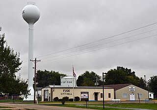
Fisk is a small city in Butler County, Southeast Missouri, United States. It is located right along the Butler-Stoddard County line on U.S. Route 60, along the St. Francis River. The population was 312 at the 2020 census.

<span class="mw-page-title-main">New Bloomfield, Missouri</span> City in Missouri, United States

New Bloomfield is a city in Cedar Township, Callaway County, Missouri, United States. The population was 669 at the 2010 census. It is part of the Jefferson City Metropolitan Statistical Area.

<span class="mw-page-title-main">Belton, Missouri</span> City in Missouri, US

Belton is a city in northwestern Cass County, Missouri, United States. The population was 23,953 at the 2020 census.

<span class="mw-page-title-main">Linneus, Missouri</span> City in Missouri, United States

Linneus is a small city in Linn County, Missouri, United States. The population was 281 at the 2020 census. It is the county seat of Linn County.

<span class="mw-page-title-main">Pineville, Missouri</span> City in Missouri, United States

Pineville is a city in and the county seat of McDonald County, Missouri, United States. The population was 802 at the 2020 census.

<span class="mw-page-title-main">Canalou, Missouri</span> City in Missouri, United States

Canalou is a city in New Madrid County, Missouri, United States. The population was 338 at the 2010 census. The ZIP code is 63828.

<span class="mw-page-title-main">Advance, Missouri</span> City in Missouri, United States

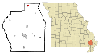
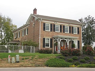
Advance is a city located at the intersection of State Highway 25 and State Highway 91/Route C in northern Stoddard County, Missouri, United States. The population was 1,347 at the 2010 census. Advance was founded circa 1882. The town is pronounced ADD-vance.

<span class="mw-page-title-main">Baker, Missouri</span> Village in Missouri, United States

Baker is an inactive incorporated village in Stoddard County, Missouri, United States. Per the 2020 census, the population was 3. As of 2017, it is Missouri's smallest incorporated settlement.

<span class="mw-page-title-main">Bell City, Missouri</span> City in Missouri, United States

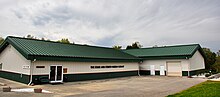
Bell City is a city in northeastern Stoddard County, Missouri, United States. It was founded as a sawmill town circa 1900, and lies at the foothills of Crowley's Ridge on Missouri Route 91. The population was 448 at the 2010 census. Dorothy Burton is the current mayor.

<span class="mw-page-title-main">Bernie, Missouri</span> City in Missouri, United States

Bernie is a city in southern Stoddard County, Missouri, United States. The population was 1,958 at the 2010 census.

<span class="mw-page-title-main">Dexter, Missouri</span> City in Missouri, United States

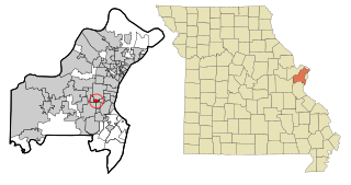
Dexter is a city in Stoddard County, Missouri, United States, founded in 1873. The population was 7,864 at the 2010 census.

<span class="mw-page-title-main">Dudley, Missouri</span> City in Missouri, United States

Dudley is a city in Stoddard County, Missouri, United States. The population was 232 at the 2010 census.

<span class="mw-page-title-main">Essex, Missouri</span> City in Missouri, United States

Essex is a city in Stoddard County, Missouri, United States. The population was 472 at the 2010 census.

<span class="mw-page-title-main">Penermon, Missouri</span> Village in Missouri, United States

Penermon is a village in Stoddard County, Missouri, United States. The population was 64 at the 2010 census.

<span class="mw-page-title-main">Puxico, Missouri</span> City in Missouri, United States

Puxico is a city in Stoddard County, Missouri, United States. The population was 881 at the 2010 census.

<span class="mw-page-title-main">Bloomfield, Nebraska</span> City in Nebraska, United States

Bloomfield is a city in Knox County, Nebraska, United States. The population was 1,028 at the 2010 census.

<span class="mw-page-title-main">Warson Woods, Missouri</span> City in Missouri, United States

Warson Woods is a city in St. Louis County, Missouri, United States. The population was 1,962 at the 2010 census.

<span class="mw-page-title-main">Trenton, Ohio</span> City in Ohio, United States

Trenton is a city in northeastern Butler County, Ohio, United States, west of Middletown. The population was 13,021 at the 2020 census. It is part of the Cincinnati metropolitan area.

<span class="mw-page-title-main">Stoddard, Wisconsin</span> Village in Wisconsin, United States

Stoddard is a village in Vernon County, Wisconsin, United States. The population was 840 at the 2020 census.

References

  1. 1 2 3 U.S. Geological Survey Geographic Names Information System: Bloomfield, Missouri
  2. "ArcGIS REST Services Directory". United States Census Bureau. Retrieved August 28, 2022.
  3. 1 2 "U.S. Census website". United States Census Bureau . Retrieved January 31, 2008.
  4. "Bloomfield city, Missouri - Census Bureau Profile". United States Census Bureau. Retrieved March 1, 2024.
  5. "Find a County". National Association of Counties. Archived from the original on May 31, 2011. Retrieved June 7, 2011.
  6. "Stoddard County Place Names, 1928–1945". The State Historical Society of Missouri. Archived from the original on June 24, 2016. Retrieved December 26, 2016.
  7. Earngey, Bill (1995). Missouri Roadsides: The Traveler's Companion. University of Missouri Press. p. 18. ISBN   9780826210210.
  8. Eaton, David Wolfe (1918). How Missouri Counties, Towns and Streams Were Named. The State Historical Society of Missouri. p. 366.
  9. "Post Offices". Jim Forte Postal History. Retrieved December 26, 2016.
  10. "National Register Information System". National Register of Historic Places . National Park Service. July 9, 2010.
  11. Missouri Atlas & Gazetteer, DeLorme, 1st ed., 1998, P.68, ISBN   0899332242
  12. "US Gazetteer files 2010". United States Census Bureau. Archived from the original on January 25, 2012. Retrieved July 8, 2012.
  13. "Census of Population and Housing". Census.gov. Retrieved June 4, 2015.
  14. "U.S. Census website". United States Census Bureau . Retrieved July 8, 2012.
  15. Matthews, Ben (September 2, 2020). "Words During Wars: Bloomfield Stars and Stripes Museum expands". Southeast Missourian. Retrieved September 6, 2020.
  16. "Bloomfield R-Xiv School District". Great Schools. Retrieved March 17, 2018.
  17. "Missouri Public Libraries". PublicLibraries.com. Archived from the original on June 10, 2017. Retrieved March 17, 2018.