North American blizzard of 2006

Last updated

North American blizzard of 2006
Category 2 "Significant" (RSI/NOAA: 5.13)
02-12-2006-1245z.png
NASA satellite image of the storm at peak intensity on February 12, featuring a hurricane-like "eye".
Type Extratropical cyclone
Nor'easter
Blizzard
Winter storm
FormedFebruary 11, 2006
DissipatedFebruary 13, 2006
Lowest pressure971 [1]   mb (28.67  inHg)
Maximum snowfall
or ice accretion
30.2 inches (77 cm) in Fairfield, Connecticut [2]
Fatalities0 direct, 3 indirect
Damage$5 million (2006 USD)
Power outages506,000
Areas affected Virginia, Maryland, District of Columbia, Pennsylvania, New York, New Jersey, Delaware, New England, Atlantic Canada

The North American blizzard of 2006 was a nor'easter that began on the evening of February 11, 2006. It dumped heavy snow across the Mid-Atlantic and New England states, from Virginia to Maine through the early evening of February 12, and ended in Atlantic Canada on February 13. The major cities from Baltimore to Boston received at least a foot of snow, with a second-highest amount of 26.9 inches (68 cm) in New York City, the (at the time) most since at least 1869, the start of record keeping, only broken by the January 2016 United States blizzard nearly 10 years later.

Contents

Meteorological synopsis

Another NASA satellite image of the storm. NASABlizzard2006.jpg
Another NASA satellite image of the storm.

Since the heaviest snow was confined to a fairly small, but very heavily populated area, the storm was only ranked as a low-end Category 3 (Major) on the new Northeast Snowfall Impact Scale, which takes into account the area and population affected, as well as snowfall accumulations. [3] This indirectly also reflects the fact that casualties were extremely low and cleanup was fairly quick, even in the New York City area where the record snow amounts occurred. The main reasons for this are: A) The storm fell on a Sunday when many people can more easily stay home, B) the relatively small geographic area of extremely large snowfall, and C) Because the temperature was well below freezing throughout most of the storm, the snow was mostly dry and light in composition, as opposed to the wet and heavy snows that make some otherwise lesser storms much harder to clean up from and are more common at least in the coastal Northeast. Additionally, temperatures in the days after the storm were unseasonably warm in some spots (reaching the mid-50s °F in hard-hit New York City, and the mid 60s in DC) which helped melt the snow much more quickly than usual.

The storm system began developing on February 11 as a relatively minor system, bringing some snow along the southern Appalachian range. The low pressure center moved off-shore early February 12 before it began its rapid intensification. By early morning, snow began falling heavily, taking several forecasters by surprise who had expected about a foot of snow, at most, along the eastern fringes of the Atlantic seaboard. During the height of the storm on Sunday morning the 12th, thunder and lightning occurred as the snow fell.

The extreme intensification was partially the result of a fairly mild winter that kept water temperatures in the Atlantic a few degrees warmer than they normally are in February. The storm system's intensity led to snowfall accumulations upwards of 32 inches (81 cm) in some localities.

In addition to the heavy snow, coastal flooding from storm surge was reported, particularly in Massachusetts. [4] Storm surges have been recorded as high as 3 feet (0.91 m) in parts of New England. [5]

The low pressure area began forming in the Southern states a few days prior to the Blizzard striking, eventually merging with a northern stream system. A trough on the East Coast brought the system up the coast, and cold high pressure to the north eventually slowed the system to a crawl. As the system completed bombing, or rapid decrease in central pressure (a common measure of the strength of a storm), mesoscale banding features (areas of significant snowfall associated with smaller scale physical phenomena) impinged on the entire I-95 Corridor.

The low pressure center was so deep that somewhat of an eye actually formed. Rarely do eyes form on storms other than hurricanes, and it is especially rare in extratropical cyclones. NASA took a satellite picture of the eye of the storm; the eye was located south and east of southern New Jersey in this picture.

Impact

A map of the states and provinces affected North America blizzard 2006.png
A map of the states and provinces affected
A radar reflectivity loop of the blizzard in the New York City area. Northeast Snowfall Impact Scale.gif
A radar reflectivity loop of the blizzard in the New York City area.

Three casualties occurred as a result of the snow: in Virginia, a man died due to his truck sliding off a highway; in Baltimore, a person died in a house fire as a result of snow delaying rescue workers from getting to the fire. [6] A third fatality occurred in a weather-related accident in Nova Scotia. [7]

Connecticut

While Connecticut was one of the hardest hit areas, the state was well-prepared for the storm and managed to avoid major problems. Hartford received a total of 21.9 inches (56 cm) of snow — the second largest snowfall since 1906. A total of 18 inches (46 cm) fell in the small Sandy Hook village. [8] West Hartford totaled 27 inches (69 cm) and Fairfield saw 27.8 inches (71 cm) of snow. Despite the large amounts of snow, there were only isolated individual power outages. At the storm's onset, governor M. Jodi Rell ordered all tractor-trailer trucks off the state's highways to facilitate the efforts of highway crews with snow removal. Motorists whose vehicles were not equipped with 4-wheel drive were required to use snow chains to travel on state roadways during the storm. Connecticut mobilized 2,500 state-owned and privately contracted snowplows to keep state highways open during the storm. The state's 169 cities and towns employed hundreds of additional plows to keep local roads passable. Bradley International Airport was closed for several hours, and the storm disrupted service on Metro North.

Delaware

New Castle County and Wilmington felt the brunt of this storm, with 14 to 15 inches (36 to 38 centimetres) of snow. Kent and Sussex counties to the south mixed with rain for a while, and saw significantly less snow accumulations, mostly in the 6 inches (15 cm) range.

District of Columbia

The city of Washington, D.C. missed the worst of the storm. The city received about 10 inches (25 cm) of snow, far less than in the suburbs. Approximately 3,000 people lost electricity in the District of Columbia. [9] However, Ronald Reagan Washington National Airport (just across the Potomac River) was closed.

Maryland

The heaviest snow in Maryland fell from the northern suburbs of Washington, D.C., to the Baltimore area. These areas overwhelmingly saw over a foot of snow. Snowfall rates of 2 to 3 inches (5 to 8 centimetres) per hour were common, and thundersnow occurred. Snowfall amounts of up to 21 inches (53 cm) were reported in Columbia, 13.1 inches (33 cm) in Baltimore, 17 inches (43 cm) in Catonsville, and a foot (30.5 cm) in Potomac. This was the area's heaviest snow since the North American blizzard of 2003. Lesser amounts occurred in western and southern parts of the state.

Maryland was hardest hit by power outages. In the Baltimore area, more than 62,000 people lost electricity, plus another 16,000 in Montgomery County and 37,000 in Prince George's County.

Massachusetts

The most serious coastal problems were in Massachusetts. The heaviest snow was in the central part of the state, where snow amounts of up to 20 inches (51 cm) were reported. Coastal areas, particularly around Nantucket, saw lesser amounts (approximately 12") as it was mixed with sleet at times, but winds of up to 60 mph (97 km/h) whipped up the ocean with storm surges of 2 to 3 feet (61 to 91 cm) and led to some coastal flooding, plus offshore waves of up to 25 feet (7.6 m). Logan International Airport in Boston and Barnstable municipal airport in Hyannis on Cape Cod saw over 90% of their flights cancelled at the peak of the storm.

There were no power outages, despite the conditions. [10] There was one death; a tree fell onto a pickup truck in Billerica, killing the driver. [11] Strong winds across the state caused $1.9 million in damage (2006 USD). [12]

New Jersey

The impact of the blizzard in northern New Jersey was strong enough to stop the New Jersey Transit bus service between 7:30 a.m. and 4:00 p.m., although trains continued to run (with some delays). [13] Many roads remained closed. Businesses were closed for most of the day. 16,000 people were without power in the state. Central and northeastern New Jersey saw the brunt of the storm due to heavy banding through the night into the morning: 21 in (53 cm) of snow fell at Newark Airport and 27" fell in Rahway. The first Wicked Faire took place as scheduled.

New York

Prospect Heights, Brooklyn on February 12 Prospect Heights Blizzard NYC 2-12-06.jpg
Prospect Heights, Brooklyn on February 12

The New York metropolitan area received the brunt of the February Blizzard of 2006. All three of the airports in the New York City area (LaGuardia Airport, John F. Kennedy International Airport and Newark Liberty International Airport) were closed during the record blizzard, for the first time since the September 11, 2001 attacks. Like the Blizzard of 1996, this winter storm does not meet the criteria to be called a blizzard, however. The winds were not strong enough, and visibility was not poor enough. Thundersnow, which is a rare occurrence in New York, occurred for about a 4-hour period in parts of The Bronx, Manhattan, Brooklyn, Queens, Rockland and Westchester during the height of the storm early Sunday morning.

Central Park received 26.9 inches (68 cm) of snow, the largest amount for a single storm since records began, breaking the record of 26.4 inches (67 cm) that fell on December 26, 1947. By comparison, the blizzards of 1996 and 2003 dropped 20.2 and 19.8 inches (51 and 50 cm) in Central Park respectively. The smallest amounts of snowfall were recorded in portions of Nassau County, including the towns of Oceanside, Lynbrook, Rockville Centre and Island Park. The snow removal cost in New York City alone is estimated at $27 million. [14] It took nearly two days for utility crews to fully restore service to as many as 300,000 customers. [11]

A loader clears snow in New York City during a lull in the snowfall on Sunday, February 12 LoaderBlizzard2006.jpg
A loader clears snow in New York City during a lull in the snowfall on Sunday, February 12

The storm did not reach very far north of the city; the Albany area only received 1–2 inches (3–5 centimetres) of snow. As a result, the 2005–06 winter season ended up being the first time ever since records began in the late 19th century that New York City received more snow than Albany in a given winter (the inland, upstate city averages about twice as much snowfall per winter as its big neighbor to the south).

The strong winds downed trees and powerlines, resulting in $3 million in damage (2006 USD). [12] The Long Island Rail Road reported extensive delays and as many as eight trains disabled up to several hours after the blizzard. The Monday morning commute was no better, as two of the railroad's lines were shut down completely and delays caused headaches for ambitious commuters. By Tuesday, two days after the storm, service was back to normal. [15]

Despite the record snowfall, New York City schools were open on February 13, owing to planning and work by the city and its snowplow team.

Pennsylvania

Snowfall totals were measured at 12 inches (30 cm) at Philadelphia International Airport, but 35 miles (56 km) to the west in West Caln Township, there were 21 inches (53 cm). Philadelphia International Airport remained open throughout the storm, although about 50% of flights were cancelled. There were also power outages in the Philadelphia area, with about 10,000 customers losing power. But in contrast, in Western Pennsylvania most got 1 in (2.5 cm) or less of snow. [16] Philadelphia public and parchocial schools were closed for the day. [17]

Rhode Island

The Governor of Rhode Island, Donald Carcieri, declared a statewide state of emergency due to the blizzard conditions. [18] The Providence Journal reported that state accumulations were generally between 9 and 19 inches (23 and 48 centimetres). Generally, Providence County received the heaviest accumulations in the state (see the chart below). On February 12, the bulk of the snow ended around 5:00 p.m. Eastern Standard Time, with flurries lasting through the early evening. No significant power outages or injuries were reported. [19]

Virginia

Picture of Falls Church, Virginia, just outside Washington, D.C. Falls church va, during Blizzard in Feb 2006.jpg
Picture of Falls Church, Virginia, just outside Washington, D.C.

According to Dominion Power, over 64,000 people in Northern Virginia lost power in the storm, primarily in the suburban areas adjacent to Washington, D.C. [9] Many locations in the extreme northeastern portion of the state recorded 10–15 in (25–38 cm) of snow, with Falls Church and Fairfax coming in at 13.5 and 14.0 in (34 and 36 cm) respectively. Fairfax County and eastern Loudoun County were generally the start of the 12+" (30+ cm) accumulations, which spread north towards Massachusetts.

Atlantic Canada

While the snowfall amounts diminished somewhat (to about 6 to 12 inches (300 mm) or 15 to 30 cm) by the time the storm tracked east into Atlantic Canada, the winds increased substantially. The worst of the storm was felt along the Atlantic coast, particularly in a swath around the Bay of Fundy, the Northumberland Strait and the south coast of Newfoundland. Hurricane-force wind gusts were reported in several communities, peaking at 156 km/h (97 mph) in Grand Etang, Nova Scotia (equal to a Category 2 hurricane) and 133 km/h (83 mph) in Cape Race on the east coast of Newfoundland. Some damage was reported as a result of the strong winds, particularly downed power lines but also some roof damage to buildings.

Observed accumulations

NOAA satellite image of the storm with descriptions and points of reference. Winter-storm-02-12-2006-1800zb.jpg
NOAA satellite image of the storm with descriptions and points of reference.
North American blizzard of 2006 snowfall accumulation for the Northeastern United States.(From the National Weather Service) February 2006 NA winter storm snowfall.PNG
North American blizzard of 2006 snowfall accumulation for the Northeastern United States.(From the National Weather Service)

Only accumulations of 8 inches (20 cm) or greater are listed. Not all observations are listed due to space limitations; only major communities and notable reports are listed.

StateCity/locationAmount in
inches (cm)
CT Fairfield 27.8 (70.6)
NJ Rahway 27.0 (68.6)
CT West Hartford 27.0 (68.6)
NY Manhattan (Central Park)26.9 (68.3)
CT Danbury 26.0 (66.0)
NY LaGuardia Airport 25.4 (64.5)
NY Bronx 24.5 (62.2)
NY New Rochelle 24.5 (62.2)
NY Brewster 24.0 (61.0)
NY Yonkers 23.9 (60.7)
CT Waterbury 23.0 (58.4)
MD Randallstown 22.0 (55.9)
MA Wilbraham 22.0 (55.9)
CT Bradley Airport 21.9 (55.6)
MD Columbia 21.3 (54.1)
NJ Newark Airport 21.3 (54.1)
CT East Granby 21.0 (53.3)
NJ East Brunswick 21.0 (53.3)
NJ Hoboken 20.7 (52.8)
CT Greenwich 20.4 (51.8)
NY Islip 20.0 (50.8)
NY New City 20.0 (50.8)
CT Norwalk 20.0 (50.8)
NJ Randolph Township 20.0 (50.8)
NY Woodbury (Nassau County) 20.0 (50.8)
RI Foster 19.0 (48.3)
NJ Ridgewood 19.0 (48.3)
NJ Glen Rock 18.7 (47.5)
PA Willow Grove 18.5 (47.0)
RI Cumberland 18.2 (46.2)
MA Cambridge 18.2 (46.2)
PA Birdsboro 18.2 (46.2)
MA Worcester 18.0 (45.8)
MA Salem 18.0 (45.8)
PA Langhorne 17.5 (44.5)
MA Logan Airport 17.5 (44.5)
NJ Clinton 17.4 (44.2)
MA Leominster 17.4 (44.2)
NJ Trenton 17.0 (43.2)
NJ Edison 17.0 (43.2)
MA Needham 17.0 (43.2)
NY JFK Airport 16.7 (42.4)
NH Nashua 16.5 (41.9)
NJ Somerville 16.5 (41.9)
ME East Machias 16.0 (40.6)
CT New Haven 16.0 (40.6)
RI Woonsocket 15.8 (40.1)
VA Linden 15.5 (39.4)
MA Boston Common 15.5 (39.4)
CT Hartford (Downtown)15.5 (39.4)
MD Glen Burnie 15.3 (38.9)
PA Allentown 15.2 (38.6)
MD Baltimore 15.0 (38.0)
MD Elkton 15.0 (38.0)
NH Hollis 15.0 (38.0)
MD Westminster 15.0 (38.0)
DE Wilmington 14.4 (36.6)
MD Gaithersburg 14.3 (36.3)
RI Cumberland 14.0 (35.6)
VA Fairfax 14.0 (35.6)
MA Gloucester 14.0 (35.6)
NJ Lumberton 14.0 (35.6)
CT Norwich 14.0 (35.6)
NH Salem 14.0 (35.6)
VA Falls Church 13.5 (34.3)
MA Plainville 13.5 (34.3)
MD BWI Airport 13.1 (33.3)
NJ Ewing 13.1 (33.3)
PA Easton 13.0 (33.0)
MD Hagerstown 13.0 (33.0)
VA Manassas 13.0 (33.0)
CT Bridgeport 12.5 (31.8)
PA Philadelphia (Downtown)12.5 (31.8)
VA Haymarket 12.3 (31.2)
TN Gatlinburg 12.0 (30.5)
ME Kennebunk 12.0 (30.5)
PA Philadelphia Airport 12.0 (30.5)
MA Springfield 11.0 (27.9)
NY Lynbrook 11.0 (27.9)
MD Frederick 10.5 (26.7)
WV Harpers Ferry 10.0 (25.4)
VA Arlington 10.0 (25.4)
WV Martinsburg 10.0 (25.4)
ME Southwest Harbor 9.5 (24.1)
RI Providence (Downtown)9.0 (22.9)
VA Winchester 8.9 (22.6)
DC Washington (Capitol Hill)8.8 (22.4)
VA Dulles Airport 8.1 (20.6)

Sources: National Weather Service local offices – Sterling, VA, Mount Holly, NJ, Upton, NY, Taunton, MA, Caribou, ME [ dead link ], Gray, ME

See also

Related Research Articles

<span class="mw-page-title-main">North American blizzard of 1996</span>

The North American blizzard of 1996 was a severe nor'easter that paralyzed the United States East Coast with up to 4 feet (1.2 m) of wind-driven snow from January 6 to January 8, 1996. The City University of New York reported that the storm "dropped 20 inches of snow, had wind gusts of 50 mph and snow drifts up to 8 feet high." This storm was a classic example of a nor'easter, but the storm would not have been as historically significant without the presence of the arctic high pressure system located to the north of New York. It was followed by another storm, an Alberta Clipper, on January 12, then unusually warm weather and torrential rain which caused rapid melting and river flooding in the Northeast Floods later that month. Along with the March Superstorm of 1993 and the January 2016 United States blizzard, it is one of only three snowstorms to receive the top rating of 5, or "Extreme", on the Northeast Snowfall Impact Scale (NESIS).

The Early Winter 2006 North American storm complex was a severe winter storm that occurred on November 26, 2006, and continued into December 1. It affected much of North America in some form, producing various kinds of severe weather including a major ice storm, blizzard conditions, high winds, extreme cold, a serial derecho and some tornadoes.

<span class="mw-page-title-main">December 2009 North American blizzard</span>

The December 2009 North American blizzard was a powerful nor'easter that formed over the Gulf of Mexico in December 2009, and became a major snowstorm that affected the East Coast of the United States and Canadian Atlantic provinces. The snowstorm brought record-breaking December snowfall totals to Washington, D.C., Baltimore, and Philadelphia.

<span class="mw-page-title-main">February 5–6, 2010 North American blizzard</span>

The February 5–6, 2010 North American blizzard, commonly referred to as Snowmageddon, was a blizzard that had major and widespread impact in the Northeastern United States. The storm's center tracked from Baja California Sur on February 2, 2010, to the east coast on February 6, 2010, before heading east out into the Atlantic. Effects were felt to the north and west of this track in northern Mexico, California, and the southwestern, midwestern, southeastern, and most notably Mid-Atlantic states. Severe weather, including extensive flooding and landslides in Mexico, and historic snowfall totals in every one of the Mid-Atlantic states, brought deaths to Mexico, New Mexico, Virginia, Pennsylvania, and Maryland.

<span class="mw-page-title-main">February 9–10, 2010 North American blizzard</span> Severe weather event

The February 9–10, 2010 North American blizzard was a winter and severe weather event that afflicted the Midwest, Mid-Atlantic and New England regions of the United States between February 9–11, 2010, affecting some of the same regions that had experienced a historic Nor'easter three days prior. The storm brought 10 to 20 inches of snow across a wide swath from Washington, DC to New York City, with parts of the Baltimore metro area receiving more than 20 inches (51 cm). This storm began as a classic "Alberta clipper", starting out in Canada and then moving southeast, and finally curving northeast while rapidly intensifying off the New Jersey coast, forming an eye. The National Weather Service, in an interview with The Baltimore Sun's weather reporter Frank Roylance, likened this storm to a Category 1 hurricane. Forecasters told Roylance that "Winds topped 58 mph over part of the Chesapeake Bay, and 40 mph gusts were common across the region as the storm's center deepened and drifted slowly along the mid-Atlantic coast". This storm system, in conjunction with the first storm 3 days prior, has been nicknamed Snoverkill.

<span class="mw-page-title-main">February 25–27, 2010 North American blizzard</span> Winter Storm

The February 25–27, 2010 North American blizzard was a winter storm and severe weather event that occurred in the Mid-Atlantic and New England regions of the United States between February 24 and 26, 2010. The storm dropped its heaviest snow of 12 to 24 inches across a wide area of interior New England, New York, and Pennsylvania. The storm also brought flooding rains to coastal sections of New England, with some areas experiencing as much as 4 inches (10 cm). Aside from precipitation, the Nor'easter brought hurricane-force sustained winds to coastal New England.

<span class="mw-page-title-main">Weather of 2008</span>

Global storm activity of 2008 profiles the major worldwide storms, including blizzards, ice storms, and other winter events, from January 1, 2008 to December 31, 2008. A winter storm is an event in which the dominant varieties of precipitation are forms that only occur at cold temperatures, such as snow or sleet, or a rainstorm where ground temperatures are cold enough to allow ice to form. It may be marked by strong wind, thunder and lightning, heavy precipitation, such as ice, or wind transporting some substance through the atmosphere. Major dust storms, Hurricanes, cyclones, tornados, gales, flooding and rainstorms are also caused by such phenomena to a lesser or greater existent.

<span class="mw-page-title-main">December 2010 North American blizzard</span> Blizzard

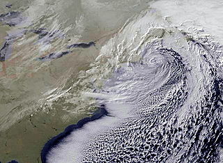
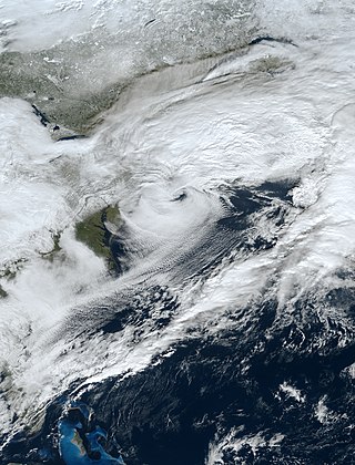
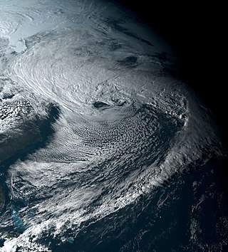
The December 2010 North American blizzard was a major nor'easter and historic blizzard affecting the Contiguous United States and portions of Canada from December 22–29, 2010. From January 4–15, the system was known as Windstorm Benjamin in Europe. It was the first significant winter storm of the 2010–11 North American winter storm season and the fifth North American blizzard of 2010. The storm system affected the northeast megalopolis, which includes major cities such as Norfolk, Philadelphia, Newark, New York City, Hartford, Providence, and Boston. It brought between 12 and 32 inches of snow in many of these areas.

<span class="mw-page-title-main">2011 Groundhog Day blizzard</span> 2011 blizzard affecting the U.S. and Canada

The 2011 Groundhog Day blizzard was a powerful and historic winter storm that affected large swaths of the United States and Canada from January 31 to February 2, 2011, especially on Groundhog Day. During the initial stages of the storm, some meteorologists predicted that the system would affect over 100 million people in the United States. The storm brought cold air, heavy snowfall, blowing snow, and mixed precipitation on a path from New Mexico and northern Texas to New England and Eastern Canada. The Chicago area saw 21.2 inches (54 cm) of snow and blizzard conditions, with winds of over 60 mph (100 km/h). With such continuous winds, the blizzard continued to the north and affected Eastern and Atlantic Canada. Blizzard conditions affected many other large cities along the storm's path, including Tulsa, Oklahoma City, Kansas City, St. Louis, Springfield, El Paso, Las Cruces, Des Moines, Milwaukee, Detroit, Chicago, Indianapolis, Dayton, Cleveland, New York City, New York's Capital District, and Boston. Many other areas not normally used to extreme winter conditions, including Albuquerque, Dallas and Houston, experienced significant snowfall or ice accumulation. The central Illinois National Weather Service in Lincoln, Illinois, issued only their fourth blizzard warning in the forecast office's 16-year history. Snowfall amounts of 20 to 28 inches were forecast for much of Northern and Western Illinois.

<span class="mw-page-title-main">February 2013 North American blizzard</span> Noreaster in 2013

The February 2013 North American blizzard, also known as Winter Storm Nemo and the Blizzard of 2013, was a powerful blizzard that developed from the combination of two areas of low pressure, primarily affecting the Northeastern United States and parts of Canada, causing heavy snowfall and hurricane-force winds. The storm crossed the Atlantic Ocean, affecting Ireland and the United Kingdom. The nor'easter's effects in the United States received a Category 3 rank on the Northeast Snowfall Impact Scale, classifying it as a "Major" Winter Storm.

<span class="mw-page-title-main">January 31 – February 2, 2015 North American blizzard</span>

The January 31 – February 2, 2015 North American blizzard was a major winter storm that plowed through the majority of the United States, dumping as much as 2 feet (24 in) of new snowfall across a path from Iowa to New England, as well as blizzard conditions in early February 2015. It came less than a week after another crippling blizzard which impacted the Northeast with 2–3 feet of snow. It was the first of many intense winter storms to occur in the nation during the month of February, partly in due to an ongoing cold wave that was beginning to take shape shortly after the storm subsided.

<span class="mw-page-title-main">2009–10 North American winter</span>

The 2009–10 North American winter saw several major blizzards affect the Northeastern United States. It refers to winter as it occurred across the North American continent from late 2009 to early 2010. While there is no well-agreed-upon date used to indicate the start of winter in the Northern Hemisphere, there are two definitions of winter which may be used. Based on the astronomical definition, winter begins at the winter solstice, which in 2009 occurred on December 21, and ends at the March equinox, which in 2010 occurred on March 20. Based on the meteorological definition, the first day of winter is December 1 and the last day February 28. Both definitions involve a period of approximately three months, with some variability.

<span class="mw-page-title-main">January 4–8, 2017 North American winter storm</span> North American winter storm

The January 4–8, 2017 North American winter storm was a major snow and ice storm that affected the Lower 48 of the United States with winter weather. Moving ashore on the West Coast on January 3, the system produced heavy snowfall in the Sierra Mountains, with nearly 4 feet of snowfall falling in the highest elevations. After impacting the Northwest and Southwest, the winter storm went on to strike the Southeast on January 5–6 with snow and ice, with snowfall accumulations up to 4 inches (10 cm). Afterwards, it began to morph into a nor'easter as it moved off the Southeast coast late on January 6, while producing blizzard conditions in the Carolinas. It then began to affect the Northeastern United States as it tracked northwards early on January 7. It produced a swath of moderate snowfall accumulations up the East Coast, with easternmost areas such as parts of Massachusetts receiving up to 1.5 feet (18 in) of snow.

<span class="mw-page-title-main">2018–19 North American winter</span> North American winter of 2018–19

The 2018–19 North American winter was unusually cold within the Northern United States, with frigid temperatures being recorded within the middle of the season. Several notable events occurred, such as a rare snow in the Southeast in December, a strong cold wave and several major winter storms in the Midwest, and upper Northeast and much of Canada in late January and early February, record snowstorms in the Southwest in late February, deadly tornado outbreaks in the Southeast and a historic mid-April blizzard in the Midwest, but the most notable event of the winter was a record-breaking bomb cyclone that affected much of the Central United States and Canada in mid-March. Unlike previous winters, a developing weak El Niño was expected to influence weather patterns across North America. Overall, however, winter of 2018–19 was mild along the mid- and lower parts of the East Coast, the West Coast, and most of the southern Plains. Overall, the meteorological winter of 2018-19 became the wettest on record for the United States.

The January 2019 North American winter storm was a long-lived winter storm, forming as a large area of low pressure off the Pacific Northwest shoreline January 16, making its way to the Northeast by January 21. Its effects included heavy rain/high elevation snow and gusty winds in California, severe weather in the south, near-blizzard conditions in Upstate New York, an ice storm in New England and minor coastal flooding in the Mid-Atlantic.

<span class="mw-page-title-main">November 26 – December 3, 2019 North American blizzard</span> Winter storm

The November 26 – December 3, 2019 North American blizzard was a major winter storm from the Rocky Mountains to the Northeast as well as a record-breaking windstorm along the West Coast. It occurred the week of American Thanksgiving, hampering travel for millions across the United States.

<span class="mw-page-title-main">2020–21 North American winter</span> Winter season in North America

The 2020–21 North American winter was the most significant winter season to affect North America in several years, and the costliest on record, with a damage total of at least $33.35 billion. The season featured 6 storms ranking on the Regional Snowfall Index scale, with 4 storms ranking as at least a Category 3. Most of the winter's damage and fatalities occurred due to a historic and major cold wave in mid-February. Several other significant events occurred, including a crippling early-season ice storm in the Southern Plains, a powerful nor'easter in mid-December, another major nor'easter in early February, two major and widespread winter storms in mid-February, and a major blizzard in the Rocky Mountains in mid-March. The winter-related events were responsible for at least 358 fatalities, making it the deadliest season since 1992–93. A La Niña pattern influenced much of the winter in North America.

<span class="mw-page-title-main">December 15–17, 2020 nor'easter</span> North American noreaster in 2020

The December 15–17, 2020 nor'easter was a powerful nor'easter that hammered the Northeastern United States and produced widespread swaths of over 1 foot (12 in) of snow in much of the region from December 15–17, 2020, ending a 1,000+ day high-impact snowstorm drought in much of the Mid-Atlantic and coastal New England regions. The system developed out of a weak area of low-pressure that first developed over the Central United States producing some snowfall before moving eastward, and by December 16, a new, dominant area of low pressure began to develop along the Southeast coast. This low steadily deepened as it moved along and impacted the Mid-Atlantic coastline, prompting several winter-related advisories and warnings for much of the Northeast.

<span class="mw-page-title-main">2022–23 North American winter</span> Winter season in North America

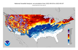
The 2022–23 North American winter was an unusually warm winter for the east and an unusually cold winter for the west in North America, as it occurred across the continent from late 2022 to early 2023. The winter season in North America began at the winter solstice, which occurred on December 21, 2022, and it ended at the March equinox, which occurred on March 20, 2023. The first day of meteorological winter began on December 1 and unofficially ended on February 28; winter storms may still occur outside of these limits.

<span class="mw-page-title-main">March 11–15, 2018 nor'easter</span> North American winter storm in 2018

A winter storm, unofficially named Winter Storm Skylar by The Weather Channel, brought widespread blizzard conditions across the Northeastern United States, particularly New England in mid-March 2018. First impacing the Midwestern and Southern United States on March 11–12 and causing travel impacts and producing high snowfall totals, the winter storm then moved into the Northeastern United States and became a nor'easter, producing blizzard conditions and heavy snowfall across portions of the interior Northeast on March 13–15. Heavy snow fell in Massachusetts, where most of the state received at least one foot of snow, and brought the heaviest March snow on record in Boston and Worcester. Over two feet of snow were reported in portions of Massachusetts, peaking at 28.3 inches (72 cm) in Methuen. Heavy snow also fell in Rhode Island, where the snowfall peaked at 25.1 inches (64 cm) in Foster.

References

  1. http://www.wpc.ncep.noaa.gov/winter_storm_summaries/storm7/stormsum_10.html [ dead link ]
  2. Record-breaking snowstorm blasts Northeastern U.S., New York Times
  3. "The Northeast Snowfall Impact Scale (NESIS)". Ncdc.noaa.gov. Retrieved 11 August 2009.
  4. "Update 26: Nor'easter Slams East From Va. to Maine - Forbes.com". Forbes . 22 February 2006. Archived from the original on 22 February 2006.
  5. confirmed by National Weather Service Boston, MA Storm Report
  6. "Northeast US hammered by record blizzard" . Retrieved 11 August 2009.[ dead link ]
  7. "CBC Nova Scotia – Shovels out in Nova Scotia". 12 February 2006. Archived from the original on 11 September 2006. Retrieved 27 August 2009.
  8. "Nor'easter pummels state, but causes little damage". Archived from the original on 22 February 2006.
  9. 1 2 "Power Outage" . Retrieved 12 February 2006.[ dead link ]
  10. "WHDH-TV – Boston – Snowstorm blankets southern New England". 28 April 2006. Archived from the original on 28 April 2006.
  11. 1 2 "CNN.com – Four killed, 250,000 without power in winter storm – Feb 18, 2006". CNN . 19 February 2006. Archived from the original on 19 February 2006.
  12. 1 2 "NCDC: Event Details". .ncdc.noaa.gov. 7 April 2006. Archived from the original on 15 January 2008. Retrieved 11 August 2009.
  13. "7online.com: New York City and Metro Area Traffic on WABC-TV 2/12/06". Abclocal.go.com. 12 February 2006. Archived from the original on 26 July 2012. Retrieved 11 August 2009.
  14. "Northeast Digs Out From Record Snowstorm". Archived from the original on 21 February 2006.
  15. "LIRR back on track two days after blizzard". Brotherhood of Locomotive Engineers. 15 February 2006. Retrieved 11 August 2009.
  16. Archived 29 September 2007 at the Wayback Machine [ dead link ]
  17. "6abc.com: Digging Out from Snowstorm 2/13/06". Abclocal.go.com. 13 February 2006. Archived from the original on 22 February 2006. Retrieved 11 August 2009.
  18. "NBC 10 NEWS – News – Blizzard Of '06 Blasts Into Southern New England". 27 February 2006. Archived from the original on 27 February 2006.
  19. "Weather data for Rhode Island" (PDF). Weather.gov. p. 98. Retrieved 24 March 2019.