North American blizzard of 2003

Last updated
North American blizzard of 2003
Category 4 "Crippling" (RSI/NOAA: 14.67)
Snowplow2.jpg
Plowing the streets of Washington, D.C. during the Blizzard of 2003
TypeWinter storm
FormedFebruary 14, 2003
DissipatedFebruary 22, 2003
Lowest pressure1011 mb
Tornadoes
confirmed
9
Max. rating1 F1 tornado
Maximum snowfall
or ice accretion
112 cm/44 in Garrett County, Maryland
Fatalities2 fatalities direct, 25 indirect
DamageOver $14.1 million [1]
Areas affectedSouthern Rockies, Central United States, Eastern North America
1Most severe tornado damage; see Fujita scale

The Blizzard of 2003, also known as the Presidents' Day Storm II or simply PDII, was a historic and record-breaking snowstorm on the East Coast of the United States and Canada, which lasted from February 14 to February 19, 2003. It spread heavy snow across the major cities of the Northeastern and Mid-Atlantic states, making it the defining snowstorm of the very snowy winter of 2002–2003.

Contents

All cities from Washington, D.C. to Boston were covered in 15–30 inches (38–76 cm) of snow [2] and those cities were brought to a standstill due to problems caused by temperatures and the snow. In Baltimore and Boston, this was the biggest snowstorm on record, with 28.2 and 27.5 inches (71.6 and 69.9 cm) respectively.

Synoptic setup

The severity of the Blizzard of 2003 can be attributed to the unusually favorable atmospheric conditions surrounding the storm (synoptic conditions). Most notably, the storm allowed for cyclogenesis off of the coastal Carolinas, a feature that is common to most major winter storms in the eastern parts of North America. This secondary system fed off the moisture of the Atlantic Ocean and enhanced precipitation totals from North Carolina to Massachusetts. Secondly, a high pressure system was in place over eastern portions of Canada, allowing for cold air to be brought down into the coastal areas in a process known as cold air advection. This cold air ensured that many areas where storms typically produce mixed precipitation received most or all precipitation in the form of snow. [3]

Meteorological history

The storm developed in the southern Rockies on February 14, and moved through southern Missouri and the Lower Tennessee Valley during the next few days. It brought heavy rain, ice and severe weather to some areas of the South, including the nation's first tornado of the year. Farther north, snow and ice affected the Midwest. Southern Iowa and eastern Illinois also got significant snow, with 11 inches (28 cm) in Des Moines. In central Kentucky the storm produced mostly ice, with some locations including Frankfort, Lexington, and nearby Cynthiana in Harrison County receiving up to 3/4" (2 cm) of ice. Much of Ohio received heavy snowfall, with Mansfield receiving 21 inches and Columbus receiving about a foot.

However, early on February 16, heavy snow started falling in those two cities, and the snow later developed in Philadelphia. Heavy snow was continuously reported, falling at rates of up to 4 inches (10 cm) per hour.[ citation needed ] In addition, temperatures were frigid, around 15 °F (-10 °C). The heavy snow continued all day, and it developed in New York City by the evening. At about the same time, the snow changed to sleet in Washington, D.C., and significantly lowered the accumulation. Throughout the rest of the Northeast, however, the snow continued for much of the night. The sleet changed back to snow by the next morning in Washington, D.C., and soon ended. By that time, a secondary low pressure system formed off the North Carolina coast and traveled north, turning the storm into a nor'easter for New York City and Boston. Blizzard Warnings were issued, and the snow began in Boston that day. In the evening, the heavy snow ended in New York City, and ended in Boston the morning of February 18. After that, the storm weakened and brought a few inches of snow to other parts of New England. The blizzard left the East Coast of the United States on February 19 and moved out into the North Atlantic Ocean. The storm weakened until it was completely absorbed by other systems on February 22.

Impact

This snowstorm paralyzed much of the East Coast with its heavy snow. All in all, it was the most significant and powerful storm to affect the major cities of the Northeast since the Blizzard of 1996. Washington's Reagan National Airport, Baltimore/Washington International Airport, Pittsburgh International Airport, Philadelphia International Airport, and LaGuardia Airport in New York City were shut down completely, and Dulles Airport had one runway open. With snow continually accumulating, road travel was nearly impossible.

The B&O Railroad Museum in Baltimore on February 17, 2003, shortly after its roof collapsed B&O Railroad Museum catastrophe.jpg
The B&O Railroad Museum in Baltimore on February 17, 2003, shortly after its roof collapsed

In Baltimore, the roof of the historic B&O Railroad Museum built in 1884 collapsed, damaging many valuable engines, historic railroad cars, and train exhibits. Although the structure's central support columns remained standing, the supporting iron struts and ties of the destroyed roofing sections failed under the heavy snow load. Some items in the museum's collection were damaged beyond repair. Reporting on the devastation the following day, The Baltimore Sun said, "...hours after the collapse, columns of mangled steel stuck out from the roundhouse ... Locomotives and passenger cars in the museum's collection, some dating from the 1830s, could be seen covered with snow and debris". [4]

Parts of the Baltimore suburbs were some of the hardest hit areas of the blizzard. Snowfall totals in the towns immediately north of the city were estimated at between 38"-40" while the downtown city center recorded only 28" of snow. The difference in reported totals resulted in conflicting reports received by the Department of Transportation. This confusion in communications resulted in the towns with the highest amounts of snow receiving delayed assistance in the cleanup while the major roadways into and out of the city were cleared.

Most Washington, D.C. area television stations had wall-to-wall coverage from Saturday morning through Monday evening, only stopping briefly overnight. Even overnight, they had constant information bars on the screen with the latest forecasts and emergency information. The University of Maryland baseball team was stranded in Florida for an extra 3 days following a tournament at Stetson University due to all flights being canceled in the Baltimore/DC area. The city of Albany, New York was shut down for three days.

Many school districts affected by the blizzard closed schools for the week. The amount of snow accumulating on the roads forced some snowplows to plow the snow into parking lots, further contributing to school closures. Many schools announced during the storm that their facilities would be closed for the duration of the week following the storm. The University System of Maryland announced on Sunday, February 16 that their campuses would not reopen until Monday, February 24. The extended closure of school districts due to this storm exacerbated the task of scheduling make-up days for the affected students, as most of these districts had already used all of their previously allocated days on storms earlier in the winter. Some districts in New Jersey ended the school year as late as June 30, 2003.

In Pennsylvania, Governor Ed Rendell declared a state of emergency early on the 17th which made state agencies available for assistance. It also freed counties from spending restrictions and allowed routes to be closed to non-emergency vehicles. The state also issued a travel advisory asking people to stay off the roads. Many municipalities (including Philadelphia and Pittsburgh) declared their own snow emergencies which banned non-essential travel and parking on snow emergency routes. There were two snow-related deaths within Philadelphia. In the southeastern part of the state, area malls closed early on the 16th and churches cancelled services.

The weight of the snow caused several roof and porch collapses throughout the region, particularly around Philadelphia where the snow mixed with sleet. Most malls and shopping centers were closed on the 17th as many employees could not get to work. Funerals and elective surgical procedures were cancelled. Businesses, universities and government offices started to reopen on Tuesday the 18th, but most schools remained closed. Organizers had to postpone scheduled events. Even Girl Scouts could not deliver their cookies. Life returned closer to normal as the week continued. Volunteers helped hospital personnel get to and from work. Blood supplies though were down to about one day. Numerous accidents occurred in the southeast part of the state during the morning of the 16th.

After that, the timing of the storm (during the holiday weekend) kept the number of accidents and rescues down. The fluffy nature of the snow led to few power outages. Most were caused by vehicles crashing into utility poles. In Philadelphia, a partially buried man was found in a snowpile on the 17th. On the 21st, a 79-year-old woman was killed after a snow-packed aluminum patio roof collapsed on her. On the 19th, a 24-year-old man was injured when his leg was trapped under the debris of a porch collapse. The worst building collapse occurred in a warehouse near the old Navy Yard. Damage to the roof and goods was 3.5 million dollars. Philadelphia International Airport remained open on the 16th, but closed on the 17th and stranded about 600 passengers at the airport. The Greyhound bus terminal closed on the 17th.

SEPTA regional rail lines ran on weekend schedules through Tuesday the 18th. About 400,000 tons of snow were dumped into the Schuylkill River. The city estimated snow removal cost about 8 million dollars. It took until the 18th to plow side streets. The worst accident of the storm occurred early on the 16th as six vehicles collided near Academy Road on Interstate 95. In Delaware County, all trolley and bus routes were closed through the 18th as were schools and county offices. Snowmobiles were used to rescue trapped motorists. In Chester County, a major accident during the early afternoon of the 16th closed the eastbound lanes of the Pennsylvania Turnpike between Morgantown and Downingtown for three hours. In Montgomery County, in Conshohocken, two people were killed in an early morning fire on the 17th. Firefighters were hampered by the ongoing storm. Lengthy delays occurred on the 16th on U.S. Route 422, the Pennsylvania Turnpike and the Northeast Extension to the Pennsylvania Turnpike. A string of porch collapses occurred on the 19th in Norristown.

In Bucks County, a woman died of a heart attack. Emergency personnel could not reach her. The eastbound lanes of the Pennsylvania Turnpike near the Philadelphia Interchange were shut down during the afternoon of the 16th because of a multi-vehicle accident that set a couple of them ablaze. In Nockamixon and Bridgeton Townships, an avalanche closed a mile of River Road. Several drivers were stranded and had to be rescued. The snow was 10 feet high on the roadway. In the Lehigh Valley, even police cruisers were getting stuck in the snow. Non-four-wheel drive vehicles could not move. The Lehigh Valley International Airport remained opened, but most flights were canceled. There was no public transportation on the 17th.

The blizzard was part of a winter remarkable for its snowstorms in the affected states, where total snowfall for the season ranked in the top ten and even higher in some areas. In sections of the coastal northeast, 75 inches of total snowfall occurred that year. Some Maryland communities getting more than three feet of snow in the President's Day blizzard, such as Kingsville and Perry Hall,[ citation needed ] experienced more than 80 inches of snow for the entire winter season.[ citation needed ]

Tornado outbreak

February 15

List of confirmed tornadoes – Saturday, February 15, 2003 [note 1]
F# LocationCounty / ParishStateCoord.DateTime (UTC)Path lengthMax widthSummary
F1 Delcambre Vermilion LA 29°57′N92°00′W / 29.95°N 92.00°W / 29.95; -92.00 (Delcambre (February 15, F1)) February 1517:00–17:020.5 mi (0.80 km)10 yd (9.1 m)A brief tornado impacted a mobile home park, lofting several trailers in the process. Four were destroyed, including one thrown 75 yd (69 m) onto a telephone pole and another onto a neighboring structure. One person was injured in the latter of these incidents. [5] The trailer park suffered damage from Hurricane Lili just four months prior. [6] Displaced residents were provided hotel stays and the local Red Cross chapter assisted them. During operational forecasts, radar signatures did not show indications of a tornado and showed winds no more than 30 mph (50 km/h). [7]
F0N of Puckett Rankin MS 32°08′N89°47′W / 32.13°N 89.78°W / 32.13; -89.78 (Puckett (February 15, F0)) February 1522:20–22:221 mi (1.6 km)50 yd (46 m)A brief tornado damage the roofs of three chicken houses, uprooted trees, and snapped branches. [8]
F0E of Polkville Smith, Scott MS 32°11′N89°36′W / 32.18°N 89.60°W / 32.18; -89.60 (Polkville (February 15, F0)) February 1522:43–22:533.5 mi (5.6 km)75 yd (69 m)A short-lived tornado touched down in the Bienville National Forest, causing damage to many trees along a narrow path. [9] A few structures sustained roof damage. [10]
F1NW of Lawrence Newton MS 32°21′N89°16′W / 32.35°N 89.27°W / 32.35; -89.27 (Lawrence (February 15, F1)) February 1523:25–23:272 mi (3.2 km)75 yd (69 m)A mobile home was knocked off its foundation and the structure's porch was destroyed. Four chicken houses sustained major damage and hay barn had part of its roof torn off and thrown 0.25 mi (0.40 km) away. Numerous trees were also felled. [11]
F1NNW of Linden Marengo AL 32°20′N87°49′W / 32.33°N 87.82°W / 32.33; -87.82 (Linden (February 15, F1)) February 1502:36–02:402.5 mi (4.0 km)80 yd (73 m)This tornado occurred along the northern edge of a bow echo and impacted areas northwest of Providence. One home suffered significant damage while two mobile homes had minor damage. Numerous trees were blown down throughout Chickasaw State Park. [12] [13]

February 16

List of confirmed tornadoes – Sunday, February 16, 2003 [note 1]
F# LocationCounty / ParishStateCoord.DateTime (UTC)Path lengthMax widthSummary
F1 Tyndall Air Force Base Bay FL 30°04′N85°35′W / 30.07°N 85.58°W / 30.07; -85.58 (Tyndall Air Force Base (February 16, F1)) February 1610:000.2 mi (0.32 km)200 yd (180 m)A waterspout moved onshore at the Tyndall Air Force Base, [14] damaging more than thirty vehicles, one of which was thrown into a building. [15]
F0 Vernon Washington FL 30°38′N85°43′W / 30.63°N 85.72°W / 30.63; -85.72 (Vernon (February 16, F0)) February 1610:300.2 mi (0.32 km)75 yd (69 m)A brief tornado damaged several homes; trees and power lines were downed. [16]
F0 Port St. Joe Gulf FL 29°49′N85°18′W / 29.82°N 85.30°W / 29.82; -85.30 (Port St. Joe (February 16, F0)) February 1612:370.2 mi (0.32 km)75 yd (69 m)A waterspout moved onshore in northern Port St. Joe and damaged a dozen homes. Many trees and power lines were downed. [17]
F1N of Cairo Grady, Mitchell GA 31°02′N84°12′W / 31.03°N 84.20°W / 31.03; -84.20 (Cairo (February 16, F1)) February 1613:25–13:302.4 mi (3.9 km)150 yd (140 m)A tornado touched down near the Grady–Mitchell county line, damaging two homes in the area. [18] Some grass was torn from the ground as well. [14] In Mitchell County, three mobile homes were destroyed, three frame homes suffered major damage, and several others were impacted. [19] One person suffered minor bruises. [14]

Other effects

This storm was part of the same system that caused that year's Daytona 500 to be rain-shortened. Michael Waltrip won the race. [20]

See also

Notes

  1. 1 2 All dates are based on the local time zone where the tornado touched down; however, all times are in Coordinated Universal Time for consistency.

Related Research Articles

<span class="mw-page-title-main">Tornado outbreak of April 27–28, 2002</span> Tornado Outbreak in April 2002

A widespread, destructive tornado outbreak affected Iowa, Kansas, Missouri, and Nebraska on April 27, 2002, and Illinois, Indiana, Kentucky, Maryland, New York, Ohio, Pennsylvania, Tennessee, Virginia, and West Virginia on the following day, April 28. Generally, tornado reports were widely scattered in each state, but significant to severe damage was noted in multiple states. Overall, 48 tornadoes were confirmed along with 6 deaths, 256 injuries, and $224 million in damage, with wind and hail adding to the damage total.

<span class="mw-page-title-main">Anticyclonic tornado</span> Tornadoes that spin in the opposite direction of normal tornadoes

An anticyclonic tornado is a tornado which rotates in a clockwise direction in the Northern Hemisphere and a counterclockwise direction in the Southern Hemisphere. The term is a naming convention denoting the anomaly from normal rotation which is cyclonic in upwards of 98 percent of tornadoes. Many anticyclonic tornadoes are smaller and weaker than cyclonic tornadoes, forming from a different process, as either companion/satellite tornadoes or nonmesocyclonic tornadoes.

<span class="mw-page-title-main">Hurricane Katrina tornado outbreak</span> August 2005 tornado outbreak in southeastern United States

Accompanying Hurricane Katrina's catastrophic coastal impacts was a moderate tornado outbreak spawned by the cyclone's outer bands. The event spanned August 26–31, 2005, with 57 tornadoes touching down across 8 states. One person died and numerous communities suffered damage of varying degrees from central Mississippi to Pennsylvania, with Georgia sustaining record monetary damage for the month of August. Due to extreme devastation in coastal areas of Louisiana and Mississippi, multiple tornadoes may have been overlooked—overshadowed by the effects of storm surge and large-scale wind—and thus the full extent of the hurricane's tornado outbreak is uncertain. Furthermore, an indeterminate number of waterspouts likely formed throughout the life cycle of Hurricane Katrina.

<span class="mw-page-title-main">Tornado outbreak of May 1–3, 2008</span>

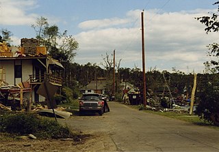
A destructive and deadly tornado outbreak that took place across the Southern and Central United States from May 1 to May 3, 2008. The outbreak was responsible for at least seven fatalities and 23 injuries in Arkansas. There were at least 29 tornado reports from Iowa to Oklahoma on May 1 and 67 more in Arkansas, Missouri, Mississippi, Tennessee, Louisiana and Texas on May 2. A total of 60 tornadoes were confirmed by weather authorities.

The tornado outbreak of April 1–2, 1974, affected much of the eastern and central United States. Four fatalities and more than seventy injuries were confirmed in this outbreak. Damaging, deadly tornadoes struck Kentucky, Tennessee, and Alabama—including the Nashville and Huntsville metropolitan areas. In the latter areas, tornadoes produced F3 damage on the Fujita scale and impacted areas that would later sustain damage on April 3. Large hail and severe thunderstorm winds also impacted a broad area.

<span class="mw-page-title-main">Tornado outbreak of June 2, 1998</span>

On Tuesday, June 2, 1998, one of the most significant tornado outbreaks in recent history hit the east-central United States. The severe weather event spawned a total of 33 tornadoes in nine states from New York to South Carolina and caused an estimated $40 million in damage, 77 injuries and 2 fatalities. For Pennsylvania in particular, it was the second historic and deadly severe weather outbreak in three days, as it immediately followed the late-May 1998 tornado outbreak and derecho.

<span class="mw-page-title-main">February 2016 North American winter storm</span> Climate phenomenon in North America

The February 2016 North American winter storm was a strong winter storm that caused more than 70,000 people in southern California to lose their electricity, with many broken trees and electrical lines in that area, with the Southern Rocky Mountains having the potential to receive some of the greatest snowfall from the system. One person in San Diego, California area died when a tree fell on their car. Another person in Minnesota died after being struck by a car while crossing a street.

<span class="mw-page-title-main">Tornado outbreak of February 23–24, 2016</span>

An unusually prolific and very destructive late-winter tornado outbreak resulted in significant damage and numerous casualties across the southern and eastern half of the United States between February 23–24, 2016. Lasting over a day and a half, the outbreak produced a total of 61 tornadoes across eleven states, which ranked it as one of the largest February tornado outbreaks in the United States on record, with only the 2008 Super Tuesday tornado outbreak having recorded more. In addition, it was also one of the largest winter tornado outbreaks overall as well. The most significant and intense tornadoes of the event were four EF3 tornadoes that struck southeastern Louisiana, Pensacola, Florida, Evergreen, Virginia, and Tappahannock, Virginia. Tornadoes were also reported in other places like Texas, Florida, and Pennsylvania. Severe thunderstorms, hail and gusty winds were also felt in the Northeastern United States and Mid-Atlantic states on February 24 as well.

<span class="mw-page-title-main">Tornado outbreak and floods of April 28 – May 1, 2017</span> 2017 severe weather in central US

Between April 28 – May 1, 2017, a series of severe weather events affected the Central United States, producing life-threatening flooding and a major tornado outbreak. It formed out of a disturbance in the Southwestern United States on April 28, and caused significant impacts, including a heavy snowstorm in the Rockies, and other types of severe weather. Up to 3 feet (36 in) of snow fell on the cold side of the system, and up to a foot of rain fell in and around the central parts of the nation.

<span class="mw-page-title-main">March 20–22, 2018 nor'easter</span> Cyclone

The March 20–22, 2018 nor'easter, dubbed the "Four'easter" in some media outlets, brought additional significant late-season snowfall to the Northeastern United States, after three previous such nor'easters had struck the general region on March 1–3, 6–8, and 12–15, respectively. affected the Mid-Atlantic states and New England with over 18 in (46 cm) of heavy snow and whiteout conditions. It also affected areas of the Southeastern and Midwestern United States with both snowfall and severe weather. The nor'easter was also one of the heaviest spring snowstorms on record in some areas in the Mid-Atlantic, especially Philadelphia and New York City.

<span class="mw-page-title-main">April 2018 North American storm complex</span>

The April 2018 North American storm complex brought a wide swath of severe and winter weather that affected much of Midwest across to the East Coast of the United States. This particular outbreak led to at least 73 confirmed tornadoes over a three-day period, most of which occurred across Arkansas and Louisiana during the evening hours of April 13. The most significant tornadoes were an EF1 that caused a fatality in Red Chute, Louisiana, early on April 14, an upper-end EF2 tornado that impacted eastern sections of Greensboro, North Carolina on April 15, causing 17 injuries, and a significant EF3 tornado that impacted areas from Lynchburg to Elon, Virginia, causing severe damage and at least 10 injuries.

<span class="mw-page-title-main">March 2019 North American blizzard</span> Colorado Low storm

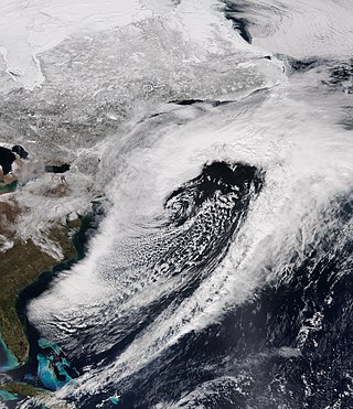
The March 2019 North American blizzard was a powerful Colorado Low that produced up to two feet of snow in the plains and Midwest. Rapid snowmelt following the storm caused historic flooding, and some areas received hurricane-force wind gusts. Comparable to the 1993 Storm of the Century, the storm was labeled a bomb cyclone after barometric pressure readings dropped in excess of 24 mbar (0.71 inHg) over a 24-hour period. After the storm entered Colorado from its origination in Arizona, the pressure dropped more than 30 mbar (0.89 inHg) and rapidly intensified over the western High Plains. The severe storm set new all-time record low barometric pressure readings in Colorado, Kansas and New Mexico. The storm itself killed only one person in Colorado, but flooding caused by the storm killed at least 3, one in Iowa and at least two in Nebraska and left ~140,000 without power in Texas.

<span class="mw-page-title-main">November 2020 North American storm complex</span>

The November 2020 North American storm complex was a major early-season snowstorm that impacted most of the Ohio Valley from November 30–December 2 with heavy snow, gusty winds, and near-whiteout conditions. The system originated from a weak gulf low off the coast of Texas on November 29, which began to move northeastward onto land the next day. It then began to strengthen, as well as slowing its movement down, resulting in heavy, wind-driven snow for prolonged periods of time in the Ohio Valley. It also triggered a major lake-effect snow event from December 1–2 as the system stalled over Lake Ontario, resulting in additional heavy snowfall. The storm system was also responsible for a severe thunderstorm outbreak in the Southeast and Mid-Atlantic regions, causing 22 severe thunderstorms and 5 tornadoes. In total, the system is estimated to have caused at least $100 million in damages. It was unofficially named Winter Storm Dane by The Weather Channel.

<span class="mw-page-title-main">March 2021 North American blizzard</span> Winter storm and tornado outbreak in 2021

The March 2021 North American blizzard was a record-breaking blizzard in the Rocky Mountains and a significant snowstorm in the Upper Midwest that occurred in mid-March 2021. It brought Cheyenne, Wyoming their largest two-day snowfall on record, and Denver, Colorado their second-largest March snowfall on record. The storm originated from an extratropical cyclone in the northern Pacific Ocean in early March, arriving on the west coast of the United States by March 10. The storm moved into the Rocky Mountains on Saturday, March 13, dumping up to 2–3 feet (61–91 cm) of snow in some areas. It was unofficially given the name Winter Storm Xylia.

<span class="mw-page-title-main">Tornado outbreak of March 16–18, 2021</span> 2021 tornado outbreak and blizzard in the United States

A tornado outbreak occurred on Saint Patrick's Day in the Deep South. Mississippi and Alabama were greatly affected, with numerous tornadoes being confirmed, including four that were rated EF2. Six people were injured by four different tornadoes across Alabama during the outbreak. A non-tornadic fatality also occurred due to a car crash near Natchez, Mississippi. The outbreak began the day before, with a couple tornadoes in Mississippi, and continued over the next two days. The storm moved eastward and affected portions of Florida, Georgia, the Carolinas, and Virginia on March 18, spawning more tornadoes and causing wind damage before the storms pushed offshore that night. In total, 51 tornadoes were confirmed during the event, including 25 in Alabama, making it the sixth-largest tornado event in the state's history, and is sometimes locally referred to as the Saint Patrick's Day tornado outbreak of 2021. The same areas would be hit again by a more significant and destructive tornado outbreak sequence one week later.

<span class="mw-page-title-main">December 2021 Midwest derecho and tornado outbreak</span> 2021 severe weather outbreak in the Midwest United States

On December 15, a rapidly-deepening low-pressure area contributed to a historic expanse of inclement weather across the Great Plains and Midwestern United States, resulting in an unprecedented December derecho and tornado outbreak across portions of the Northern United States, a region normally affected by snow and cold weather during this time of year. Non-thunderstorm winds spurred the formation of rapidly-moving fires across Colorado and western Kansas, with attendant dust and debris spreading eastward. From central Kansas northeastward into eastern Wisconsin, the powerful derecho led to hundreds of damaging wind reports. At least 57 hurricane-force wind reports were received by the National Weather Service, signaling the most prolific wind event in the United States dating back to at least 2004. Numerous embedded circulations within this rapidly-progressing derecho produced dozens of tornadoes, including 33 that were rated EF2. The culmination of non-thunderstorm, thunderstorm, and tornadic winds caused widespread damage to structures, trees, power lines, and vehicles across the Plains and Midwest. At least 600,000 people lost power on December 15, and temperatures dropped significantly across the affected region following the event, causing accumulating snow, which hindered cleanup and recovery efforts. The storm killed at least 5 people directly, as well as 2 people indirectly through wildfires partly spawned by the storm, and caused at least $1.8 billion in damages. The number of tornadoes in this event broke a record for largest outbreak in the month of December that had been set less than a week prior. The event also became one of the largest single-day outbreaks in recorded history, with 120 tornadoes occurring over an eight-hour period.

<span class="mw-page-title-main">Weather of 2017</span>

The following is a list of weather events that occurred in 2017.

<span class="mw-page-title-main">April 2022 North American storm complex</span> 2022 American storm complex

The April 2022 North American storm complex affected much of the Rocky Mountains and the Midwestern United States with tornadoes, heavy snow, and gusty winds. The system in general first began impacting the Northwest on April 11, before moving eastward into the Rocky Mountains the following day. It was also responsible for producing a large severe weather outbreak of tornadoes and damaging straight-line wind in the Midwest and South while contributing to a powerful blizzard in the upper Midwest states of North and South Dakota.

References

  1. NWS Sterling. "NWS Sterling Storm Reports, February 2003" (PDF). Retrieved 2007-02-15.
  2. "Historic Blizzards | Farmers' Almanac". Archived from the original on 2012-11-10. Retrieved 2013-02-12.
  3. Robert Wevodau. "The President's Day Snowstorm II - A Case History". Archived from the original on 2006-03-30. Retrieved 2007-02-16.
  4. Jamie Siegel; Frederick Rasmussen (2003-02-18). "Snow causes roof of railroad museum to partially cave in". The Baltimore Sun . p. 9A. Retrieved 2008-10-27.
  5. Louisiana Event Report: F1 Tornado (Report). National Centers for Environmental Information. 2003. Retrieved January 10, 2022.{{cite report}}: Unknown parameter |agency= ignored (help)
  6. Rosa, Chris (February 16, 2003). "Winds rip Delcambre trailers". Abbeville Meridional. p. 1A. Retrieved January 11, 2003 via Newspapers.com. Lock-green.svg
  7. Stohlman, Lindsay (February 16, 2003). "Strong winds destroy Delcambre homes". The Daily Advertiser via Newspapers.com. Lock-green.svg
  8. Mississippi Event Report: F0 Tornado (Report). National Centers for Environmental Information. 2003. Retrieved January 11, 2022.{{cite report}}: Unknown parameter |agency= ignored (help)
  9. Mississippi Event Report: F0 Tornado (Report). National Centers for Environmental Information. 2003. Retrieved January 11, 2022.{{cite report}}: Unknown parameter |agency= ignored (help)
  10. Mississippi Event Report: F0 Tornado (Report). National Centers for Environmental Information. 2003. Retrieved January 11, 2022.{{cite report}}: Unknown parameter |agency= ignored (help)
  11. Mississippi Event Report: F1 Tornado (Report). National Centers for Environmental Information. 2003. Retrieved January 11, 2022.{{cite report}}: Unknown parameter |agency= ignored (help)
  12. Alabama Event Report: F1 Tornado (Report). National Centers for Environmental Information. 2003. Retrieved January 11, 2022.{{cite report}}: Unknown parameter |agency= ignored (help)
  13. "Marengo County Tornado...February 15, 2003". National Weather Service Forecast Office in Birmingham, Alabama. 2003. Retrieved January 11, 2022.
  14. 1 2 3 "Severe Weather Event of February 16, 2003". National Weather Service Forecast Office in Tallahassee, Florida. 2003. Retrieved January 11, 2022.
  15. Florida Event Report: F1 Tornado (Report). National Centers for Environmental Information. 2003. Retrieved January 11, 2022.{{cite report}}: Unknown parameter |agency= ignored (help)
  16. Florida Event Report: F0 Tornado (Report). National Centers for Environmental Information. 2003. Retrieved January 11, 2022.{{cite report}}: Unknown parameter |agency= ignored (help)
  17. Florida Event Report: F0 Tornado (Report). National Centers for Environmental Information. 2003. Retrieved January 11, 2022.{{cite report}}: Unknown parameter |agency= ignored (help)
  18. Georgia Event Report: F1 Tornado (Report). National Centers for Environmental Information. 2003. Retrieved January 11, 2022.{{cite report}}: Unknown parameter |agency= ignored (help)
  19. Georgia Event Report: F1 Tornado (Report). National Centers for Environmental Information. 2003. Retrieved January 11, 2022.{{cite report}}: Unknown parameter |agency= ignored (help)
  20. Waltrip wins rain-shortened Daytona 500, CBC, February 16, 2023