December 2009 North American blizzard

Last updated

December 2009 North American blizzard
Category 4 "Crippling" (RSI/NOAA: 12.78)
December 2009 nor'easter.jpg
Satellite image of the nor'easter on December 20 near the Mid-Atlantic states.
Type Extratropical cyclone
Blizzard
Winter storm
FormedDecember 16, 2009 [1]
DissipatedDecember 20, 2009
Lowest pressure968 millibars (28.6 inHg) [2]
Tornadoes
confirmed
4
Max. rating1 EF0 tornado
Maximum snowfall
or ice accretion
26.3 inches (67 cm) [3]
Fatalities7 fatalities [4]
Areas affected East Coast of the United States (from North Carolina to Maine)
Canadian Atlantic provinces (portions of Nova Scotia, Newfoundland, Labrador) [5]

1Most severe tornado damage; see Fujita scale

The December 2009 North American blizzard was a powerful nor'easter that formed over the Gulf of Mexico in December 2009, and became a major snowstorm that affected the East Coast of the United States and Canadian Atlantic provinces. The snowstorm brought record-breaking December snowfall totals to Washington, D.C., Baltimore, and Philadelphia.

Contents

The blizzard disrupted several regions, and in some areas the snowfall rate prevented snow plows from maintaining the roads. The blizzard caused flights and trains to be canceled, and left areas without power. Kentucky, Maryland, Virginia, West Virginia, and New Castle and Kent counties in Delaware declared a state of emergency. Seven deaths were reported to have been caused by the storm.

Meteorological history

On December 16, 2009, meteorologists identified a storm forming in the Gulf of Mexico. [6] It produced record rainfall in regions of Texas and had the potential to strengthen as it moved through Georgia and Florida and further north. Weather models accurately predicted that this storm would meet with cold air while retaining its heavy precipitation. [1] By the afternoon of December 19, the large, low pressure region had moved off the East Coast, intensifying and bringing heavy snow to the major Mid-Atlantic cities. [7] [8] Blizzard warnings were issued in Washington, D.C., Baltimore, and Long Island. [1] As the storm moved northward along the East coast, at one point it measured 500 miles (800 km) across 14 states. [9] The storm produced whiteout conditions and dumped about 16–20 inches (41–51 cm) of snow in major cities along the Eastern seaboard. [10]

After the blizzard in Old Fort, North Carolina. A foot of snow fell. Snow in old fort.JPG
After the blizzard in Old Fort, North Carolina. A foot of snow fell.
Impassable road in Ashe County, North Carolina after the 2009 blizzard Blizzard 2009 Ashe Co 2.jpg
Impassable road in Ashe County, North Carolina after the 2009 blizzard

Snowfall

The storm produced record 24-hour snowfall in Washington, D.C., and Roanoke, Virginia, where nearly 2 feet (61 cm) of snow accumulated. Interior areas of West Virginia saw 30 inches (76 cm) of snow. [3] The storm broke the record for the amount of snow in a single December event at Ronald Reagan Washington National Airport, where 16.4 inches (42 cm) of snow accumulated. [8] [11] The National Weather Service in Brookhaven, New York reported 26.3 inches (67 cm) of snow, the town's largest snowfall since 1949. [12] [13]

Snowfall during the blizzard in Clifton, Virginia completely covers a road and reduces visibility Home noreaster 2009.jpg
Snowfall during the blizzard in Clifton, Virginia completely covers a road and reduces visibility

In Philadelphia, snowfall reached more than 2 inches (5.1 cm) per hour, resulting in significant disruption of Interstate 95. [1] By Sunday, December 20, 23.2 inches (59 cm) of snowfall had accumulated in Philadelphia, surpassing the city's second-largest record 21 inches (53 cm) snowfall of February 11–12, 1983 – which itself was surpassed less than two months later by the February 5–6, 2010 North American blizzard. The storm also broke a 100-year-old record for the largest single December storm, previously 20.2 inches (51 cm) on December 25–26, 1909. [14] The storm was reported by meteorologists to share attributes of the 1983 storm. [15]

Streetscape of the Dupont Circle neighborhood of Washington, D.C. Blizzard - Dupont Circle.jpg
Streetscape of the Dupont Circle neighborhood of Washington, D.C.

In more mountainous areas, snowfall was even heavier. By midnight Saturday morning, snowfall in Boone, North Carolina had reached 14–18 inches (36–46 cm), Asheville, North Carolina accumulated up to 12 inches (30 cm), while Greensboro, North Carolina received 3–7 inches (7.6–17.8 cm). Portions of eastern Kentucky received as much as 16 inches (41 cm). [16] In the Roanoke Valley, over 11 inches (28 cm) had fallen by midnight. By Sunday morning, Norwich, Connecticut received 20 inches (51 cm) of snow, while over 11 inches (28 cm) of snow fell in Boston, Massachusetts. [17]

Winter storm warnings for New York and a blizzard warning for Long Island expired at 11 a.m. Sunday, warnings for the Boston and Providence metro areas and much of southeastern New England expired at noon. A blizzard warning for Cape Cod expired at 1 p.m. [18] The storm reached southwestern portions of Nova Scotia, delivering up to 25 centimetres (9.8 in) of snow in Digby, Yarmouth, Shelburne and Queens counties. Portions of Newfoundland and Labrador received freezing rain as well. [5] [19]

Snowfall totals by state

Impact

A DDOT snowplow driving past diplomatic missions on P Street, NW, in Dupont Circle, Washington, D.C. P Street - snow removal.JPG
A DDOT snowplow driving past diplomatic missions on P Street, NW, in Dupont Circle, Washington, D.C.

Some regions affected by the storm experienced winds up to 25–30 miles per hour (40–48 km/h) with gusts of 45–50 miles per hour (72–80 km/h). [3] Ronald Reagan Washington National Airport, Washington Dulles International Airport, and Baltimore/Washington International Thurgood Marshall Airport saw whiteout conditions, causing flights to be delayed or canceled. Of 740 scheduled departures at Washington National and 530 at Dulles, only 14 and 12, respectively, were able to take off. [20] President Barack Obama, arriving at Andrews Air Force Base after the UN Climate Conference, was forced to return to the White House by motorcade instead of helicopter. [21] More than 800 flights were canceled at New York City's three major airports. [22] Delays averaged over six hours at Philadelphia International Airport. [23]

Many Amtrak trains were also canceled or delayed and service on Washington, D.C.'s Metrorail was suspended to all outdoor stations at 1 pm on December 19 and remained suspended until late in the day December 20; underground service remained operational. [20] One Amtrak train, carrying 255 passengers, halted for six hours while a frozen track switch was fixed. [11]

On roads, snow plows were unable to keep up with fast snow accumulations. Road accidents and stuck vehicles further hindered snow removal. On some major highways, traffic slowed to five miles per hour. [24] In West Virginia, on I-77 between Ghent and Beckley, thousands of motorists were stranded for up to 18 hours due to impassable roads. The interstate was closed for 15 hours. Governor Joe Manchin has launched a full investigation into why the roads were in such poor condition. Greyhound Lines canceled 294 routes through Maryland, Virginia, Washington, D.C., and West Virginia on December 19 and suspended service in and out of New York late Saturday. [25]

Cars buried by nearly 24 inches (61 cm) of snow in Woodley Park, Washington, D.C., on December 19 Blizzard aftermath car + 23.5 inches of snow.jpg
Cars buried by nearly 24 inches (61 cm) of snow in Woodley Park, Washington, D.C., on December 19
National Weather Service image showing snowfall accumulation for the Mid-Atlantic states December 2009 Winter Storm NEUSA snowfall.PNG
National Weather Service image showing snowfall accumulation for the Mid-Atlantic states

Thousands of power outages were reported in Virginia, Kentucky, and North Carolina, reportedly caused by snow weighing down on power lines. By midnight Saturday morning, when the storm had just begun to strike the area, reported power outages had already exceeded 40,000. [1] In Kentucky, 107,000 power outages were reported. [16] A snow emergency was declared in Washington, D.C., where Mayor Adrian Fenty asked residents to avoid venturing onto the roads. [26] States of emergency were declared in Kentucky, Maryland, Virginia, West Virginia and New Castle and Kent counties in Delaware. [25]

The storm was held responsible for seven deaths in North Carolina, Ohio, Pennsylvania, Virginia, and West Virginia, including one death resulting from a head-on collision between a snowmobile driver and a horse-drawn carriage. [4]

The nor'easter, which arrived on the last weekend before Christmas, hurt sales at retail stores in affected regions, but boosted online sales. Super Saturday, the last Saturday before Christmas, typically nets $15 billion in retail sales. [27] It is estimated that 30% of this revenue comes from the northeastern United States. [26] Stores that managed to open saw reduced traffic. [28] The storm resulted in an estimated loss of $2 billion in retail sales. [29]

Due to widespread accumulation of heavy snow, the storm was ranked as a high-end Category 2 ("significant") winter storm, on the Northeast Snowfall Impact Scale. The ranking is based on the amount of snowfall, the area, and the population affected. [30]

Tornado outbreak

The same system produced severe weather in Florida. Four EF0 tornadoes touched down in the state, causing mostly minor damage. [31]

See also

Related Research Articles

<span class="mw-page-title-main">Blizzard</span> Type of snowstorm

A blizzard is a severe snowstorm characterized by strong sustained winds and low visibility, lasting for a prolonged period of time—typically at least three or four hours. A ground blizzard is a weather condition where snow is not falling but loose snow on the ground is lifted and blown by strong winds. Blizzards can have an immense size and usually stretch to hundreds or thousands of kilometres.

<span class="mw-page-title-main">1993 Storm of the Century</span> Category 5 noreaster in the United States

The 1993 Storm of the Century was a cyclonic storm that formed over the Gulf of Mexico on March 12, 1993. The cold weather, heavy snowfall, high winds and storm surges that the storm brought affected a very large area; at its height, it stretched from Canada to Honduras. The cyclone moved through the Gulf of Mexico and then through the eastern United States before moving on to eastern Canada. It eventually dissipated in the North Atlantic Ocean on March 15.

<span class="mw-page-title-main">North American blizzard of 1996</span>

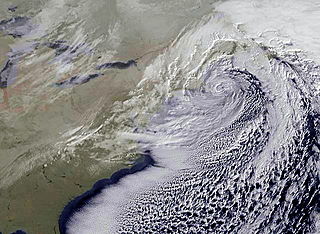
The North American blizzard of 1996 was a severe nor'easter that paralyzed the United States East Coast with up to 4 feet (1.2 m) of wind-driven snow from January 6 to January 8, 1996. The City University of New York reported that the storm "dropped 20 inches of snow, had wind gusts of 50 mph and snow drifts up to 8 feet high." This storm was a classic example of a nor'easter, but the storm would not have been as historically significant without the presence of the arctic high pressure system located to the north of New York. It was followed by another storm, an Alberta Clipper, on January 12, then unusually warm weather and torrential rain which caused rapid melting and river flooding in the Northeast Floods later that month. Along with the March Superstorm of 1993 and the January 2016 United States blizzard, it is one of only three snowstorms to receive the top rating of 5, or "Extreme", on the Northeast Snowfall Impact Scale (NESIS).

<span class="mw-page-title-main">North American blizzard of 2003</span>

The Blizzard of 2003, also known as the Presidents' Day Storm II or simply PDII, was a historic and record-breaking snowstorm on the East Coast of the United States and Canada, which lasted from February 14 to February 19, 2003. It spread heavy snow across the major cities of the Northeastern and Mid-Atlantic states, making it the defining snowstorm of the very snowy winter of 2002–2003.

<span class="mw-page-title-main">North American blizzard of 2006</span> Winter storm in North America in 2006

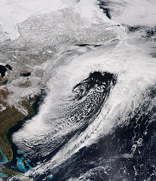
The North American blizzard of 2006 was a nor'easter that began on the evening of February 11, 2006. It dumped heavy snow across the Mid-Atlantic and New England states, from Virginia to Maine through the early evening of February 12, and ended in Atlantic Canada on February 13. The major cities from Baltimore to Boston received at least a foot of snow, with a second-highest amount of 26.9 inches (68 cm) in New York City, the most since at least 1869, the start of record keeping, only broken by the January 2016 United States blizzard nearly 10 years later.

<span class="mw-page-title-main">2009 North American Christmas blizzard</span>

The 2009 North American Christmas blizzard was a powerful winter storm and severe weather event that affected the Midwestern United States, Great Plains, Southeastern United States, the Eastern Seaboard, and parts of Ontario. The storm began to develop on December 22 before intensifying to produce extreme winds and precipitation by the morning of December 24. The storm's rapid development made it difficult for forecasters to predict. The blizzard was reported to have claimed at least 21 lives, and disrupted air travel during the Christmas travel season. In the Southeastern and Central United States, an outbreak of 28 tornadoes occurred between December 23–24. The storm, a Category 5 "Extreme" one on the Regional Snowfall Index scale, was the first winter weather event to rank as such since the North American blizzard of 1996.

<span class="mw-page-title-main">February 5–6, 2010, North American blizzard</span>

The February 5–6, 2010 North American blizzard, commonly referred to as Snowmageddon, was a blizzard that had major and widespread impact in the Northeastern United States. The storm's center tracked from Baja California Sur on February 2, 2010, to the east coast on February 6, 2010, before heading east out into the Atlantic. Effects were felt to the north and west of this track in northern Mexico, California, and the southwestern, midwestern, southeastern, and most notably Mid-Atlantic states. Severe weather, including extensive flooding and landslides in Mexico, and historic snowfall totals in every one of the Mid-Atlantic states, brought deaths to Mexico, New Mexico, Virginia, Pennsylvania, and Maryland.

<span class="mw-page-title-main">February 9–10, 2010, North American blizzard</span>

The February 9–10, 2010 North American blizzard was a winter and severe weather event that afflicted the Midwest, Mid-Atlantic and New England regions of the United States between February 9–11, 2010, affecting some of the same regions that had experienced a historic Nor'easter three days prior. The storm brought 10 to 20 inches of snow across a wide swath from Washington, DC to New York City, with parts of the Baltimore metro area receiving more than 20 inches (51 cm). This storm began as a classic "Alberta clipper", starting out in Canada and then moving southeast, and finally curving northeast while rapidly intensifying off the New Jersey coast, forming an eye. The National Weather Service, in an interview with The Baltimore Sun's weather reporter Frank Roylance, likened this storm to a Category 1 hurricane. Forecasters told Roylance that "Winds topped 58 mph over part of the Chesapeake Bay, and 40 mph gusts were common across the region as the storm's center deepened and drifted slowly along the mid-Atlantic coast". This storm system, in conjunction with the first storm 3 days prior, has been nicknamed Snoverkill.

Global weather activity of 2009 profiles the major worldwide storms, including blizzards, tornadoes, ice storms, tropical cyclones and other meteorogical events, from January 1, 2009, to December 31, 2009. Wintery storms are events in which the dominant varieties of precipitation are forms that only occur at cold temperatures, such as snow or sleet, or a rainstorm where ground temperatures are cold enough to allow ice to form. It may be marked by strong wind, thunder and lightning, heavy precipitation, such as ice, or wind transporting some substance through the atmosphere. Summer storms including flooding, severe thunderstorms and extratropical cyclones are also included in this list to a certain extent.

<span class="mw-page-title-main">Weather of 2008</span>

Global storm activity of 2008 profiles the major worldwide storms, including blizzards, ice storms, and other winter events, from January 1, 2008 to December 31, 2008. A winter storm is an event in which the dominant varieties of precipitation are forms that only occur at cold temperatures, such as snow or sleet, or a rainstorm where ground temperatures are cold enough to allow ice to form. It may be marked by strong wind, thunder and lightning, heavy precipitation, such as ice, or wind transporting some substance through the atmosphere. Major dust storms, Hurricanes, cyclones, tornados, gales, flooding and rainstorms are also caused by such phenomena to a lesser or greater existent.

<span class="mw-page-title-main">December 2010 North American blizzard</span> Blizzard

The December 2010 North American blizzard was a major nor'easter and historic blizzard affecting the Contiguous United States and portions of Canada from December 22–29, 2010. From January 4–15, the system was known as Windstorm Benjamin in Europe. It was the first significant winter storm of the 2010–11 North American winter storm season and the fifth North American blizzard of 2010. The storm system affected the northeast megalopolis, which includes major cities such as Norfolk, Philadelphia, Newark, New York City, Hartford, Providence, and Boston. It brought between 12 and 32 inches of snow in many of these areas.

<span class="mw-page-title-main">2015–16 North American winter</span>

The 2015–16 North American winter was not as frigid across North America and the United States as compared to the 2013–14 and 2014–15 winters. This was mainly due to a strong El Niño, which caused generally warmer-than-average conditions. However, despite the warmth, significant weather systems still occurred, including a snowstorm and flash flooding in Texas at the end of December and a large tornado outbreak at the end of February. The main event of the winter season, by far and large, was when a crippling and historic blizzard struck the Northeastern United States in late January, dumping up to 3 feet of snow in and around the metropolitan areas. Several other smaller snow events affected the Northeast as well, but for the most part the heaviest snowstorms and ice stayed out further west, such as a severe blizzard in western Texas in late December, and a major late-season snowstorm in Colorado in mid-April.

<span class="mw-page-title-main">January 2016 United States blizzard</span> Blizzard in January 2016 which affected the Eastern United States

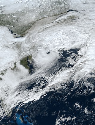
The January 2016 United States blizzard produced up to 3 ft (91 cm) of snow in parts of the Mid-Atlantic and Northeastern United States during January 22–24, 2016. A weather system, evolving from a shortwave trough that formed in the Pacific Northwest on January 19, consolidated into a defined low-pressure area on January 21 over Texas. Meteorologists indicated that a resultant storm could produce more than 2 ft (61 cm) of snow across a wide swath of the Mid-Atlantic region and could "paralyze the eastern third of the nation", and regarded it as a "potentially historic blizzard". Winter weather expert Paul Kocin described the blizzard as "kind of a top-10 snowstorm".

<span class="mw-page-title-main">2012–13 North American winter</span>

The 2012–13 North American winter started out somewhat early, as the remnants of Hurricane Sandy brought heavy snow to the mountains of West Virginia in late October. Later, a strong nor'easter affected the weary Northeastern United States, hampering storm recovery efforts and dropping several inches of snow. The rest of the winter featured several other notable events, such as a Christmas winter storm that affected most of the Eastern United States, and the most notable event occurring in early February, when a powerful blizzard struck the Northeast and brought record snow to some areas. During the winter, a weak El Nino was expected to influence weather conditions across the continent.

<span class="mw-page-title-main">2009–10 North American winter</span>

The 2009–10 North American winter saw several major blizzards affect the Northeastern United States. It refers to winter as it occurred across the North American continent from late 2009 to early 2010. While there is no well-agreed-upon date used to indicate the start of winter in the Northern Hemisphere, there are two definitions of winter which may be used. Based on the astronomical definition, winter begins at the winter solstice, which in 2009 occurred on December 21, and ends at the March equinox, which in 2010 occurred on March 20. Based on the meteorological definition, the first day of winter is December 1 and the last day February 28. Both definitions involve a period of approximately three months, with some variability.

<span class="mw-page-title-main">2010–11 North American winter</span>

The 2010–11 North American winter was influenced by an ongoing La Niña, seeing winter storms and very cold temperatures affect a large portion of the Continental United States, even as far south as the Texas Panhandle. Notable events included a major blizzard that struck the Northeastern United States in late December with up to 2 feet (24 in) of snowfall and a significant tornado outbreak on New Year's Eve in the Southern United States. By far the most notable event was a historic blizzard that impacted areas from Oklahoma to Michigan in early February. The blizzard broke numerous snowfall records, and was one of the few winter storms to rank as a Category 5 on the Regional Snowfall Index. In addition, Oklahoma set a statewide low temperature record in February.

<span class="mw-page-title-main">March 20–22, 2018 nor'easter</span> Cyclone

The March 20–22, 2018 nor'easter, dubbed the "Four'easter" in some media outlets) brought additional significant late-season snowfall to the Northeastern United States, after three previous such nor'easters had struck the general region on March 1–3, 6–8, and 12–14, respectively. affected the Mid-Atlantic states and New England with over 18 in (46 cm) of heavy snow and whiteout conditions. It also affected areas of the Southeastern and Midwestern United States with both snowfall and severe weather. The nor'easter was also one of the heaviest spring snowstorms on record in some areas in the Mid-Atlantic, especially Philadelphia and New York City.

<span class="mw-page-title-main">December 15–17, 2020, nor'easter</span> North American noreaster in 2020

The December 15–17, 2020 nor'easter was a powerful nor'easter that hammered the Northeastern United States and produced widespread swaths of over 1 foot (12 in) of snow in much of the region from December 15–17, 2020, ending a 1,000+ day high-impact snowstorm drought in much of the Mid-Atlantic and coastal New England regions. The system developed out of a weak area of low-pressure that first developed over the Central United States producing some snowfall before moving eastward, and by December 16, a new, dominant area of low pressure began to develop along the Southeast coast. This low steadily deepened as it moved along and impacted the Mid-Atlantic coastline, prompting several winter-related advisories and warnings for much of the Northeast.

<span class="mw-page-title-main">January 14–17, 2022, North American winter storm</span> Category 2 snow and ice storm in North America

The January 14–17, 2022, North American winter storm brought widespread impacts and wintry precipitation across large sections of eastern North America and parts of Canada. Forming out of a shortwave trough on January 13, it first produced a swath of snowfall extending from the High Plains to the Midwestern United States. The storm eventually pivoted east and impacted much of the Southern United States from January 15–16 before shifting north into Central Canada, the Mid-Atlantic states, and the Northeastern United States. The system, named Winter Storm Izzy by The Weather Channel, was described as a "Saskatchewan Screamer".

<span class="mw-page-title-main">2022–23 North American winter</span> Winter season in North America

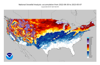
The 2022–23 North American winter was an unusually warm winter for the east and an unusually cold winter for the west in North America, as it occurred across the continent from late 2022 to early 2023. The winter season in North America began at the winter solstice, which occurred on December 21, 2022, and it ended at the March equinox, which occurred on March 20, 2023. The first day of meteorological winter began on December 1 and unofficially ended on February 28; winter storms may still occur outside of these limits.

References

  1. 1 2 3 4 5 Tim Ballisty. "Snow Totals Adding Up from Blizzard 2009". The Weather Channel. Archived from the original on December 21, 2009. Retrieved December 19, 2009.
  2. "HPC Storm Summary #9". Hydrometeorological Prediction Center. Retrieved December 20, 2009.
  3. 1 2 3 James Wilson. "Crippling snow from Mid-Atlantic to Northeast". The Weather Channel. Archived from the original on December 15, 2009. Retrieved December 19, 2009.
  4. 1 2 McFadden, Robert D.; Berger, Joseph (December 21, 2009). "Commuters Still Feel Effects of Snow". The New York Times . Retrieved December 21, 2009.
  5. 1 2 "Crippling U.S. storm moving north". CBC News . cbc.ca. December 20, 2009. Retrieved December 20, 2009.
  6. Wood, Anthony R.; Colimore, Edward. "Better watch out: Snow looks to reign". The Philadelphia Inquirer. Archived from the original on December 22, 2009. Retrieved December 19, 2009.
  7. Alex Sosnowski. "Super Saturday Blizzard to Reach Southern New England Next". Accuweather. Retrieved December 19, 2009.
  8. 1 2 Zapotosky, Matt; Morello, Carol; Halsey III, Ashely (December 20, 2009). "The great dig-out: Neighborhood streets still clogged with snow". The Washington Post . washingtonpost.com. Retrieved December 20, 2009.
  9. Griffith, Stephanie (December 21, 2009). "Record-breaking storm closes US federal government". Agence France-Presse . news.yahoo.com. Archived from the original on December 22, 2009. Retrieved December 23, 2009.
  10. "Five dead as snowstorm engulfs US East Coast". "BBC". December 20, 2009. Retrieved December 19, 2009.
  11. 1 2 "Snow socks Eastern states, halts travel". Los Angeles Times. Associated Press. Archived from the original on December 21, 2009. Retrieved December 20, 2009.
  12. McFadden, Robert D. (December 21, 2009). "Records Fall as Snow Blankets East Coast". The New York Times . pp. A1. Retrieved December 22, 2009.
  13. "Storm Crawls Into New England, Leaving Mess Behind". nytimes.com . Associated Press. December 20, 2009. Retrieved December 22, 2009.[ dead link ]
  14. Wood, Anthony (December 21, 2009). "A winter's worth of snow, before winter". The Philadelphia Inquirer . Archived from the original on December 25, 2009. Retrieved February 5, 2010.
  15. Wood, Anthony; Colimore, Edward (December 19, 2009). "Better watch out: Snow looks to reign". The Philadelphia Inquirer . Archived from the original on December 22, 2009. Retrieved February 5, 2010.
  16. 1 2 Hopkins, Shawntaye (December 19, 2009). "Gov. declares state of emergency, more than 100,000 homes without power". Lexington Herald-Leader . Retrieved December 20, 2009.
  17. Meghan Evans (December 20, 2009). "Latest Snowfall Map for Blizzard". AccuWeather.com. Retrieved December 20, 2009.
  18. "Storm heads north after socking East Coast". CNN. December 20, 2009. Retrieved December 20, 2009.
  19. Meghan Evans (December 20, 2009). "Nor'easter Still Pounding Eastern New England". AccuWeather.com. Retrieved December 20, 2009.
  20. 1 2 Asha Beh. "Above Ground, Metro Shuts Down". NBC Washington. Retrieved December 19, 2009.
  21. "Snow socks Eastern states, halts travel". Los Angeles Times. Associated Press. December 20, 2009. Archived from the original on December 21, 2009. Retrieved December 20, 2009.
  22. Joseph Berger (December 21, 2009). "Storm Finally Exits a Snow-Covered East Coast". The New York Times. Retrieved December 20, 2009.
  23. "Philadelphia Airport delays averaging 6 hours due to snowstorm". NJ.com. December 19, 2009. Retrieved August 23, 2023.
  24. "VDOT Continues to Address Winter Storm". NBC 29, WVIR-TV. Archived from the original on February 24, 2012. Retrieved December 20, 2009.
  25. 1 2 Liz Robbins (December 20, 2009). "Winter Arrives, Blanketing East Coast in Snow". The New York Times. Retrieved December 20, 2009.
  26. 1 2 Baertlein, Lisa; Klayman, Ben. "Storm threatens U.S. retailers' last holiday push". Forbes. Retrieved December 20, 2009.[ dead link ]
  27. Dodes, Rachel; Zimmerman, Ann (December 20, 2009). "Snowstorm Threatens 'Super Saturday' Sales". The Wall Street Journal.
  28. Hank Daniszewski. "Tis the Season of Bargains". London Free Press. Archived from the original on December 23, 2009. Retrieved December 20, 2009.
  29. Ylan Q. Mui (December 22, 2009). "Washington area retailers try to recoup sales lost in snowstorm". The Washington Post. Retrieved December 22, 2009.
  30. "The Northeast Snowfall Impact Scale (NESIS)". Ncdc.noaa.gov. Archived from the original on January 5, 2011. Retrieved January 15, 2010.
  31. "Florida Event Report: EF0 Tornado". National Climatic Data Center. National Weather Service Office in Miami, Florida. 2010. Retrieved December 30, 2010. "Florida Event Report: EF0 Tornado". National Climatic Data Center. National Weather Service Office in Key West, Florida. 2010. Retrieved December 30, 2010. "Florida Event Report: EF0 Tornado". National Climatic Data Center. National Weather Service Office in Tampa, Florida. 2010. Retrieved December 30, 2010. "Florida Event Report: EF0 Tornado". National Climatic Data Center. National Weather Service Office in Key West, Florida. 2010. Retrieved December 30, 2010.