
The 1968 Atlantic hurricane season was a below average hurricane season during which only seven named storms developed. The season officially began on June 1 and lasted until November 30, dates which conventionally delimit the period of each year when most tropical cyclones form in the Atlantic basin. Of the named storms, five strengthened into hurricanes; none however intensified into a major hurricane. Only four other seasons since the start of the satellite era—1972, 1986, 1994, and 2013—did not feature a major hurricane. The first system, Hurricane Abby, developed in the northwestern Caribbean on June 1. Abby moved northward and struck Cuba, bringing heavy rainfall and flooding to western portions of the island. Making landfall in Florida on June 4, Abby caused flooding and spawned four tornadoes, but left behind little damage. Overall, the hurricane resulted in six deaths and about $450,000 (1968 USD) in damage. In late June, Tropical Storm Candy brought minor flooding and spawned several tornadoes across portions of the Southern United States. Overall damage from the cyclone reached approximately $2.7 million. 1968 featured two simultaneously active tropical storms during the month of June, a phenomenon that would not occur again until 2023.
The 1973 Atlantic hurricane season was the first season to use the Saffir–Simpson hurricane scale, a scale developed in 1971 by Herbert Saffir and Robert Simpson to rate the intensity of tropical cyclones. The season produced 24 tropical and subtropical cyclones, of which only 8 reached storm intensity, 4 became hurricanes, and only 1 reached major hurricane status. Although more active than the 1972 season, 1973 brought few storms of note. Nearly half of the season's storms affected land, one of which resulted in severe damage.

The 1975 Atlantic hurricane season was a near average hurricane season with nine named storms forming, of which six became hurricanes. Three of those six became major hurricanes, which are Category 3 or higher systems on the Saffir–Simpson scale. The season officially began on June 1 and lasted until November 30. These dates conventionally delimit the period of each year when most tropical cyclones form in the Atlantic Ocean.

The 1981 Atlantic hurricane season featured direct or indirect impacts from nearly all of its 12 tropical or subtropical storms. Overall, the season was fairly active, with 22 tropical depressions, 12 of which became a namable storm, while 7 of those reached hurricane status and 3 intensified into major hurricanes. The season officially began on June 1, 1981, and lasted until November 30, 1981. These dates conventionally delimit the period of each year when most tropical cyclones form in the Atlantic basin. However, tropical cyclogenesis can occur before these dates, as demonstrated with the development of two tropical depressions in April and Tropical Storm Arlene in May. At least one tropical cyclone formed in each month between April and November, with the final system, Subtropical Storm Three, becoming extratropical on November 17, 1981.

The 1957 Atlantic hurricane season featured one of the longest-travelling tropical cyclones in the Atlantic basin, Hurricane Carrie. Nevertheless, the season was generally inactive, with eight tropical storms – two of which went unnamed – and three hurricanes, two of which intensified further to attain major hurricane intensity. The season officially began on June 15 and ended on November 15, though the year's first tropical cyclone developed prior to the start of the season on June 8. The final storm dissipated on October 27, well before the official end of the season. The strongest hurricane of the year was Carrie, which reached the equivalent of a Category 4 hurricane on the Saffir–Simpson hurricane scale on two separate occasions in the open Atlantic; Carrie later caused the sinking of the German ship Pamir southwest of the Azores, resulting in 80 deaths.

The 1956 Atlantic hurricane season featured a decent number of tropical cyclones, although most tropical storms and hurricanes affected land. There were twelve tropical storms, a third of which became hurricanes. One of the hurricanes strengthened to the equivalent of a major hurricane, which is a Category 3 or greater on the Saffir–Simpson scale. The strongest hurricane of the season was Betsy, which was also the most damaging storm of the season: it destroyed 15,000 houses and left $40 million in damage in Puerto Rico. Betsy was also the deadliest of the season, having killed 18 people in the French West Indies, two from a shipwreck in the Caribbean Sea, and 16 in Puerto Rico. Tropical Storm Dora struck Mexico in September and killed 27 people.

The 1945 Atlantic hurricane season produced multiple landfalling tropical cyclones. It officially began on June 16 and lasted until October 31, dates delimiting the period when a majority of storms were perceived to form in the Atlantic Ocean. A total of 11 systems were documented, including a late-season cyclone retroactively added a decade later. Five of the eleven systems intensified into hurricanes, and two further attained their peaks as major hurricanes. Activity began with the formation of a tropical storm in the Caribbean on June 20, which then made landfalls in Florida and North Carolina at hurricane intensity, causing one death and at least $75,000 in damage. In late August, a Category 3 hurricane on the modern-day Saffir–Simpson hurricane wind scale struck the Texas coastline, with 3 deaths and $20.1 million in damage. The most powerful hurricane of the season, reaching Category 4 intensity, wrought severe damage throughout the Bahamas and East Coast of the United States, namely Florida, in mid-September; 26 people were killed and damage reached $60 million. A hurricane moved ashore the coastline of Belize in early October, causing one death, while the final cyclone of the year resulted in 5 deaths and $2 million in damage across Cuba and the Bahamas two weeks later. Overall, 36 people were killed and damage reached at least $82.85 million.

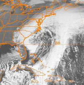
The Christmas 1994 nor'easter was an intense cyclone along the East Coast of the United States and Atlantic Canada. It developed from an area of low pressure in the southeast Gulf of Mexico near the Florida Keys, and moved across the state of Florida. As it entered the warm waters of the Gulf Stream in the Atlantic Ocean, it began to rapidly intensify, exhibiting traits of a tropical system, including the formation of an eye. It attained a pressure of 970 millibars on December 23 and 24, and after moving northward, it came ashore near New York City on Christmas Eve. Because of the uncertain nature of the storm, the National Hurricane Center (NHC) did not classify it as a tropical cyclone.
The November 2006 nor'easter was a powerful extratropical cyclone that formed offshore of the Southeastern United States on November 20, bringing heavy rains, high winds, beach erosion, and coastal flooding to the Carolinas and southern New England. In addition, the earliest snowfall ever noted in both Charleston, South Carolina and Savannah, Georgia occurred on the southwest side of this cyclone. Over 10,000 were without power during the storm. No longer a nor'easter, the extratropical cyclone accelerated rapidly across the North Atlantic while rapidly strengthening, becoming a cyclonic storm again by November 25, but this time with hurricane-force sustained winds. The intense low made a cyclonic loop west of Iceland, before being absorbed by another strengthening extratropical cyclone to the west of Great Britain, late on December 1.
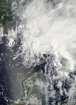
Tropical Storm Barry was a rapidly forming tropical cyclone that made landfall on Florida, United States, in early June 2007. The second named storm of the 2007 Atlantic hurricane season, Barry developed from a trough of low pressure in the southeastern Gulf of Mexico on June 1. It tracked rapidly northeastward, reaching peak winds of 60 mph (97 km/h) before weakening and making landfall near Tampa Bay as a tropical depression. Barry quickly lost tropical characteristics after wind shear removed much of the convection, and early on June 3, it completed the transition into an extratropical cyclone. The extratropical remnants tracked up the East Coast of the United States, and were absorbed by a larger extratropical cyclone on June 5.

Tropical Storm Arlene was a short lived, pre-season tropical storm which made landfall on the central Louisiana coastline on May 30, 1959, causing minor damages and one fatality. Arlene, the first named storm of the 1959 Atlantic hurricane season, developed out of a tropical wave which was first noted near the Dominican Republic on May 23. Development of the system was slow before it gained enough convection to be declared Tropical Storm Arlene on May 28. The storm slowly intensified and reached its peak intensity of 60 mph (97 km/h) on May 30. Rapid weakening took place as the storm neared land and Arlene made landfall with winds of 45 mph (72 km/h) later that night. Arlene weakened to what is now classified as a Tropical Depression early the next morning. The system degenerated into a remnant low on the afternoon of May 31 and fully dissipated late on June 2 while located over South Carolina.

Tropical Storm Beryl was the strongest off-season Atlantic tropical cyclone on record to make landfall in the United States. The second tropical cyclone of the 2012 Atlantic hurricane season, Beryl developed on May 26 from a low-pressure system offshore North Carolina. Initially subtropical, the storm slowly acquired tropical characteristics as it tracked across warmer sea surface temperatures and within an environment of decreasing vertical wind shear. Late on May 27, Beryl transitioned into a tropical cyclone less than 120 miles (190 km) from North Florida. Early the following day, the storm moved ashore near Jacksonville Beach, Florida, with peak winds of 65 mph (100 km/h). It quickly weakened to a tropical depression, dropping heavy rainfall while moving slowly across the southeastern United States. A cold front turned Beryl to the northeast, and the storm became extratropical on May 30.
The 2019 Atlantic hurricane season was the fourth consecutive above-average and damaging season dating back to 2016. However, many were weak and short-lived, especially towards the end of the season. Six of those named storms achieved hurricane status, while three intensified into major hurricanes. Two storms became Category 5 hurricanes, marking the fourth consecutive season with at least one Category 5 hurricane, the third consecutive season to feature at least one storm making landfall at Category 5 intensity, and the seventh on record to have multiple tropical cyclones reaching Category 5 strength. The season officially began on June 1 and ended on November 30. These dates historically describe the period each year when most tropical cyclones form in the Atlantic basin and are adopted by convention. However, tropical cyclogenesis is possible at any time of the year, as demonstrated by the formation of Subtropical Storm Andrea on May 20, making this the fifth consecutive year in which a tropical or subtropical cyclone developed outside of the official season.

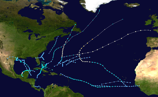
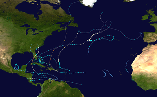
The 2020 Atlantic hurricane season was the most active Atlantic hurricane season on record, in terms of number of systems. It featured a total of 31 tropical or subtropical cyclones, with all but one cyclone becoming a named storm. Of the 30 named storms, 14 developed into hurricanes, and a record-tying seven further intensified into major hurricanes. It was the second and final season to use the Greek letter storm naming system, the first being 2005, the previous record. Of the 30 named storms, 11 of them made landfall in the contiguous United States, breaking the record of nine set in 1916. During the season, 27 tropical storms established a new record for earliest formation date by storm number. This season also featured a record 10 tropical cyclones that underwent rapid intensification, tying it with 1995, as well as tying the record for most Category 4 hurricanes in a singular season in the Atlantic Basin. This unprecedented activity was fueled by a La Niña that developed in the summer months of 2020 as it did, continue a stretch of above-average seasonal activity that began in 2016. Despite the record-high activity, this was the first season since 2015 in which no Category 5 hurricane formed.

Tropical Storm Bonnie was a weak but persistent tropical cyclone that brought heavy rains to the Southeastern United States in May 2016. The second storm of the season, Bonnie formed from an area of low pressure northeast of the Bahamas on May 27, a few days before the official hurricane season began on June 1. Moving steadily west-northwestwards, Bonnie intensified into a tropical storm on May 28 and attained peak winds six hours later. However, due to hostile environmental conditions, Bonnie weakened to a depression hours before making landfall just east of Charleston, South Carolina, on May 29. Steering currents collapsed afterwards, causing the storm to meander over South Carolina for two days. The storm weakened further into a post-tropical cyclone on May 31, before emerging off the coast while moving generally east-northeastwards. On June 2, Bonnie regenerated into a tropical depression just offshore North Carolina as conditions became slightly more favorable. The next day, despite increasing wind shear and cooling sea surface temperatures, Bonnie reintensified into a tropical storm and reached its peak intensity. The storm hung on to tropical storm strength for another day, before weakening into a depression late on June 4 and became post-tropical early the next day.
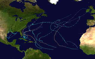
The 2022 Atlantic hurricane season was a destructive Atlantic hurricane season, which had an average number of named storms, a slightly above-average number of hurricanes, a slightly below-average number of major hurricanes, and a slightly below-average accumulated cyclone energy (ACE) index. Despite this, it became the third costliest Atlantic hurricane season on record, behind only 2017 and 2005, mostly due to Hurricane Ian. There were 14 named storms during the season. Eight of them strengthened into a hurricane, and two reached major hurricane intensity. The season officially began on June 1, and ended on November 30. These dates, adopted by convention, historically describe the period in each year when most subtropical or tropical cyclogenesis occurs in the Atlantic Ocean. This year's first Atlantic named storm, Tropical Storm Alex, developed five days after the start of the season, making this the first season since 2014 not to have a pre-season named storm.

Tropical Storm Nestor was a large but short-lived and disorganized tropical cyclone which caused widespread tornadoes and heavy rain in the Southeastern United States during mid-October 2019. The sixteenth depression and fourteenth named storm of the erratic 2019 Atlantic hurricane season, Nestor originated from a broad area of low pressure over the Western Caribbean. It emerged in the Gulf of Mexico and began to organize slightly, becoming Potential Tropical Cyclone Sixteen due to its threat to the Southeastern United States. It gained a sufficient enough of a circulation to be designated Tropical Storm Nestor near the Florida Panhandle early on October 18, crawling to the northeast, and then finally transitioning into an extratropical cyclone due to strong shear from a nearby upper-level low before making landfall on the Florida Panhandle on October 19.
Tropical Storm Arthur was a strong off-season tropical cyclone that impacted the East Coast of the United States in May 2020. The first of thirty-one depressions and thirty different named storms of the extremely active 2020 Atlantic hurricane season, Arthur marked the record sixth consecutive year in the Atlantic basin with a tropical cyclone forming before June. It was one of two off-season storms in the season, alongside short-lived Tropical Storm Bertha. Arthur originated from a front that stalled over the Straits of Florida on May 10, which slowly drifted south for two days. The system became a tropical depression on May 16 north of The Bahamas. A day later, the system intensified into a tropical storm and was named Arthur. Arthur gradually intensified while tracking towards the Outer Banks of North Carolina, attaining its peak intensity with maximum 1-minute sustained winds of 60 mph (97 km/h) and a minimum central pressure of 990 mbar (29 inHg) on May 19, before skirting the region and becoming an extratropical cyclone. The cyclone then accelerated towards Bermuda and dissipated on May 21.

Tropical Storm Bertha was a rapidly forming and short-lived off-season tropical storm that affected the Eastern United States in late May 2020. The second named storm of the very active 2020 Atlantic hurricane season, Bertha originated from a trough in the Gulf of Mexico. The National Hurricane Center (NHC) only anticipated slight development as the trough moved over southern Florida, bringing torrential rainfall. The system rapidly organized on May 27 after it emerged into the western Atlantic Ocean, developing a small, well-defined circulation. That day, the disturbance developed into Tropical Storm Bertha east of Georgia, and a few hours later it moved ashore near Isle of Palms, South Carolina with peak winds of 50 mph (80 km/h). The storm weakened over land and dissipated late on May 28 over West Virginia.

Tropical Storm Karen was a system that brought record-breaking rainfall and flooding to southeastern Pennsylvania and other Mid-Atlantic states in October 2013. The twelfth tropical cyclone and eleventh named storm of the well below-average 2013 Atlantic hurricane season, Karen originated from a tropical wave that departed from the west coast of Africa on September 16. After passing south of Jamaica and the Cayman Islands, the storm became a tropical cyclone to the northeast of the Yucatán Peninsula. The storm peaked shortly afterward, with 1-minute sustained winds of 65 mph (105 km/h). The storm triggered warnings along the Gulf Coast of the United States, but the storm ultimately degenerated into an open trough in the Gulf of Mexico without making landfall. The remnants of Karen then turned eastward and crossed Florida, before evolving into a nor'easter off the coast of North Carolina, stalling off the Delmarva Peninsula through October 12. The system weakened and drifted back southwestward towards Florida, dissipating off the coast of the state on October 15.
