Acampo, California

Last updated

Acampo
USA California Northern location map.svg
Red pog.svg
Acampo
Position in California.
USA California location map.svg
Red pog.svg
Acampo
Acampo (California)
Usa edcp location map.svg
Red pog.svg
Acampo
Acampo (the United States)
Coordinates: 38°10′19″N121°16′49″W / 38.17194°N 121.28028°W / 38.17194; -121.28028
Country Flag of the United States (23px).png  United States
State Flag of California.svg  California
County San Joaquin
Area
[1]
  Total0.94 sq mi (2.43 km2)
  Land0.94 sq mi (2.43 km2)
  Water0.00 sq mi (0.00 km2)  0%
Elevation
[2]
52 ft (16 m)
Population
 (2020)
  Total334
  Density356.08/sq mi (137.53/km2)
Time zone UTC-8 (Pacific (PST))
  Summer (DST) UTC-7 (PDT)
ZIP code
95220 [3]
Area code 209
GNIS feature ID2629758
U.S. Geological Survey Geographic Names Information System: Acampo, California

Acampo (Spanish for "Pasture") is a small census-designated place (CDP) just north of Lodi in San Joaquin County, California, United States. In the 1870s, Acampo was named as a Southern Pacific Railroad station. [4] Acampo's population was 341 at the 2010 census.

Contents

Name

Acampo was laid out in 1876 when the railroad was extended to that point. [5] The name comes from a Spanish word for "portion of the common given to the herds for pasture". [6] [7] A post office called Acampo has been in operation since 1872. [8]

Geography

According to the United States Census Bureau, the CDP covers an area of 0.9 square mile (2.4 km2), all land.

Demographics

Historical population
CensusPop.Note
2020 334
U.S. Decennial Census [9]

The 2010 United States Census [10] reported that Acampo had a population of 341. The population density was 363.7 inhabitants per square mile (140.4/km2). The racial makeup of Acampo was 169 (49.6%) White, 0 (0.0%) African American, 1 (0.3%) Native American, 3 (0.9%) Asian, 8 (2.3%) Pacific Islander, 136 (39.9%) from other races, and 24 (7.0%) from two or more races. Hispanic or Latino of any race were 199 persons (58.4%).

The Census reported that 341 people (100% of the population) lived in households, 0 (0%) lived in non-institutionalized group quarters, and 0 (0%) were institutionalized.

There were 94 households, out of which 48 (51.1%) had children under the age of 18 living in them, 54 (57.4%) were opposite-sex married couples living together, 11 (11.7%) had a female householder with no husband present, 7 (7.4%) had a male householder with no wife present. There were 8 (8.5%) unmarried opposite-sex partnerships, and 1 (1.1%) same-sex married couples or partnerships. 14 households (14.9%) were made up of individuals, and 4 (4.3%) had someone living alone who was 65 years of age or older. The average household size was 3.63. There were 72 families (76.6% of all households); the average family size was 4.11.

The population was spread out, with 105 people (30.8%) under the age of 18, 37 people (10.9%) aged 18 to 24, 79 people (23.2%) aged 25 to 44, 83 people (24.3%) aged 45 to 64, and 37 people (10.9%) who were 65 years of age or older. The median age was 30.6 years. For every 100 females, there were 114.5 males. For every 100 females age 18 and over, there were 108.8 males.

There were 99 housing units at an average density of 105.6 per square mile (40.8/km2), of which 56 (59.6%) were owner-occupied, and 38 (40.4%) were occupied by renters. The homeowner vacancy rate was 0%; the rental vacancy rate was 2.6%. 195 people (57.2% of the population) lived in owner-occupied housing units and 146 people (42.8%) lived in rental housing units.

Education

Acampo students are zoned to Lodi Unified School District schools. [11] Joe Serna Jr. Charter school is in Acampo. It is open to students of K-8th grade and specializes in teaching students in both English and Spanish. Serna shares the school campus with Houston Elementary school that operates in K-6th grades. [12]

Oak View Elementary School District operates a single K-8 school in an unincorporated area near, but not in, Acampo. High school students in the Oak View area attend the Galt Joint Union High School District. [13]

Related Research Articles

<span class="mw-page-title-main">Armona, California</span> Census-designated place in California, United States

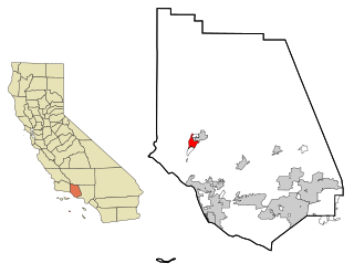
Armona is a census-designated place (CDP) in Kings County, California, United States. Armona is located 3.5 miles (5.6 km) west-southwest of Hanford, at an elevation of 239 feet (73 m). It is part of the Hanford–Corcoran Metropolitan Statistical Area. The population was 4,156 at the 2010 census. Armona's motto is "Small and Proud".

<span class="mw-page-title-main">West Carson, California</span> Unincorporated community in California, United States

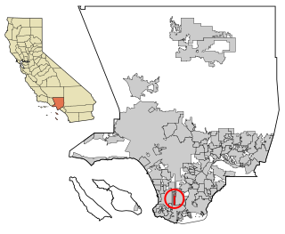
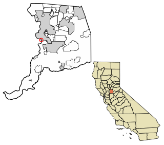
West Carson is an unincorporated community in the South Bay region of Los Angeles County, California. The population was 22,870 at the 2020 census. For statistical purposes, the United States Census Bureau has defined West Carson as a census-designated place (CDP).

<span class="mw-page-title-main">Aromas, California</span> Census-designated place in California, United States

Aromas is an unincorporated community and census-designated place (CDP) in Monterey County and San Benito County, California, United States. The population was 2,708 at the 2020 census.

<span class="mw-page-title-main">Orangevale, California</span> Census-designated place in California, United States

Orangevale is a census-designated place (CDP) in Sacramento County, California, United States. It is part of the Sacramento–Arden-Arcade–Roseville Metropolitan Statistical Area. The population was 33,960 at the 2010 census, up from 26,705 at the 2000 census. It is located approximately 25 miles (40 km) northeast of Sacramento. The community is known for its rolling hills that offer the best views of the Sierra Nevada mountain range, its foothills, and a rural environment in the middle of a growing metropolitan area. Some residential properties in the area are zoned to accommodate horses and orchards. It has a ZIP Code of 95662.

<span class="mw-page-title-main">Rosemont, California</span> Census-designated place in California, United States

Rosemont is a census-designated place (CDP) in Sacramento County, California, United States. It is part of the Sacramento–Arden-Arcade–Roseville metropolitan area. The population rose to 23,510 at the 2020 census. It was 22,681 at the 2010 census, down from 22,904 at the 2000 census.

<span class="mw-page-title-main">Alpine, California</span> Census-designated place in California, United States

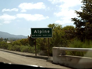
Alpine is a census-designated place (CDP) in the Cuyamaca Mountains of San Diego County, California. Alpine had a population of 14,696 at the 2020 census, up from 14,236 at the 2010 census. The town is largely surrounded by the Cleveland National Forest and borders two reservations of the Kumeyaay Nation, Viejas and Sycuan, and the rural unincorporated areas around the city of El Cajon.

<span class="mw-page-title-main">Alum Rock, San Jose</span> Neighborhood of San Jose in Santa Clara, California, United States

Alum Rock is a district of San Jose, California, located in East San Jose. Formerly an independent town, it has been a neighborhood of San Jose since the 1950s, though some portions are still unincorporated as a census-designated place. Alum Rock is one of San Jose's most notable and historic Chicano/Mexican-American districts. It is home to Alum Rock Park, the oldest municipal park in California and one of the largest in the country.

<span class="mw-page-title-main">Amesti, California</span> Census-designated place in California, United States

Amesti is a census-designated place (CDP) in Santa Cruz County, California, United States. The population was 2,637 as of the 2020 United States census.

<span class="mw-page-title-main">Eldridge, California</span> Census-designated place in California, United States

Eldridge is a census-designated place (CDP) in Sonoma County, California, United States. The population was 1,233 at the 2010 census. It is notably the home to the Sonoma Developmental Center, the largest facility serving the needs of persons with developmental disabilities in the state.

<span class="mw-page-title-main">Orosi, California</span> Census-designated place in California, United States

Orosi is a census-designated place (CDP) in Tulare County, California, United States. The population was 8,770 at the 2010 census, up from 7,318 at the 2000 census.

<span class="mw-page-title-main">Mira Monte, California</span> Rural community in Ventura County, California, United States

Mira Monte is a rural community in Ventura County, California, United States. Mira Monte is located in between the communities of Oak View, Meiners Oaks, and southwest of the City of Ojai, California. For statistical purposes, the United States Census Bureau has defined Mira Monte as a census-designated place (CDP). The census definition of the area may not precisely correspond to local understanding of the area with the same name. According to the 2020 census, the population of Mira Monte is 6,618, down from 6,845 at the 2010 census.

<span class="mw-page-title-main">Oak View, California</span> Place in California, United States

Oak View is an unincorporated community in Ventura County, California, United States. The community is located along the Ventura River in a narrow valley between the towns of Casitas Springs (south) and Mira Monte (north). Lake Casitas and the community of Ojai are also nearby. At the 2010 census, the population of Oak View was 4,066, down from 4,199 at the 2000 census, making it the third largest community between Ojai and the city of Ventura. For statistical purposes, the United States Census Bureau has defined Oak View as a census-designated place (CDP). The census definition of the area may not precisely correspond to local understanding of the area with the same name.

<span class="mw-page-title-main">Scenic Oaks, Texas</span> Census-designated place in Texas, United States

Scenic Oaks is a census-designated place (CDP) in Bexar County, Texas, United States. It is part of the San Antonio Metropolitan Statistical Area. The population was 10,458 at the 2010 census, up from 4,957 at the 2010 census.

<span class="mw-page-title-main">Adin, California</span> Census-designated place in California, United States

Adin is a census-designated place in Modoc County, California. It is located 29 miles (47 km) southwest of Alturas, at an elevation of 4,203 feet (1,281 m). Its population is 205 as of the 2020 census, down from 272 from the 2010 census.

<span class="mw-page-title-main">Allensworth, California</span> Place in California, United States

Allensworth is an unincorporated community in Tulare County, California. Established by Allen Allensworth in 1908, the town was the first in California to be founded, financed, and governed by African-Americans.

Oak Hills is a census-designated place in the Victor Valley of the Mojave Desert, within San Bernardino County, California.

Tahoma is a census-designated place in Placer and El Dorado counties, California, United States. Tahoma is located along Lake Tahoe 2 miles (3.2 km) southeast of Homewood. Tahoma has a population of 1,191.

Thornton is a census-designated place (CDP) in San Joaquin County, California, United States. Thornton is located along Interstate 5 7 miles (11 km) west-southwest of Galt. Thornton has a post office with ZIP code 95686.

<span class="mw-page-title-main">Freeport, California</span> Census-designated place in California, United States

Freeport, California is a census-designated place located approximately 7.5 miles (12.1 km) south of downtown Sacramento on California State Route 160. Freeport lies on the eastern banks of the Sacramento River in Sacramento County. The population was 58 at the 2020 census.

Acalanes Ridge is a census-designated place in Contra Costa County, California. Acalanes Ridge sits at an elevation of 499 feet (152 m). The population was 1,285 at the 2020 Census.

References

  1. "2020 U.S. Gazetteer Files". United States Census Bureau. Retrieved October 30, 2021.
  2. U.S. Geological Survey Geographic Names Information System: Acampo, California
  3. "Acampo CA ZIP Code". zipdatamaps.com. 2023. Retrieved February 17, 2023.
  4. Gudde, Erwin; William Bright (2004). California Place Names (Fourth ed.). University of California Press. p. 3. ISBN   0-520-24217-3.
  5. "Older towns dot valley when Lodi established". Lodi News-Sentinel. September 9, 1969. pp. 8C. Retrieved October 28, 2015.
  6. Gannett, Henry (1905). The Origin of Certain Place Names in the United States. p. 23.
  7. Erwin G. Gudde; William Bright (May 10, 2004). California Place Names: The Origin and Etymology of Current Geographical Names. University of California Press. p. 3. ISBN   978-0-520-24217-3 . Retrieved January 20, 2012.
  8. "Older towns dot valley when Lodi established". Lodi News-Sentinel. September 9, 1969. pp. 8C. Retrieved October 28, 2015.
  9. "Census of Population and Housing". Census.gov. Retrieved June 4, 2016.
  10. "2010 Census Interactive Population Search: CA - Acampo CDP". U.S. Census Bureau. Archived from the original on September 23, 2015. Retrieved July 12, 2014.
  11. "SCHOOL DISTRICT REFERENCE MAP (2010 CENSUS): San Joaquin County, CA." U.S. Census Bureau. Retrieved on July 10, 2018.
  12. Home. Houston Middle School. Retrieved on July 10, 2018.
  13. "History." Oak View Elementary School District. Retrieved on July 10, 2018.