Garden Acres, California

Last updated

Garden Acres
San Joaquin County California Incorporated and Unincorporated areas Garden Acres Highlighted.svg
Location in San Joaquin County and the state of California
Usa edcp location map.svg
Red pog.svg
Garden Acres
Location in the United States
Coordinates: 37°57′41″N121°13′53″W / 37.96139°N 121.23139°W / 37.96139; -121.23139
Country Flag of the United States (23px).png  United States
State Flag of California.svg  California
County San Joaquin
Government
   Senate Susan Eggman (D)
   Assembly Carlos Villapudua (D)
   U. S. Congress Josh Harder (D) [1]
Area
[2]
  Total2.589 sq mi (6.704 km2)
  Land2.589 sq mi (6.704 km2)
  Water0 sq mi (0 km2)  0%
Elevation
33 ft (10 m)
Population
 (2020) [3]
  Total11,398
  Density4,400/sq mi (1,700/km2)
Time zone UTC-8 (PST)
  Summer (DST) UTC-7 (PDT)
ZIP code
95215
Area code 209
FIPS code 06-28182
GNIS feature ID1867024

Garden Acres is a census-designated place (CDP) in San Joaquin County, California, United States. The population was 10,648 at the 2010 census, up from 9,747 at the 2000 census. It is the most populous CDP in San Joaquin County.

Contents

Geography

Garden Acres is located at 37°57′41″N121°13′53″W / 37.96139°N 121.23139°W / 37.96139; -121.23139 (37.961373, -121.231345). [4]

According to the United States Census Bureau, the CDP has a total area of 2.6 square miles (6.7 km2), all of it land.

Popular nickname of the community is Okieville. All of Okieville lies east of California Highway 99. Garden Acres is further subdivided; as north of Main Street is known as Bigville, and south of Main Street known as Littleville.

Demographics

Historical population
CensusPop.Note
U.S. Decennial Census [5]

2010

The 2010 United States Census [6] reported that Garden Acres had a population of 10,648. The population density was 4,113.4 inhabitants per square mile (1,588.2/km2). The racial makeup of Garden Acres was 5,244 (49.2%) White, 233 (2.2%) African American, 172 (1.6%) Native American, 358 (3.4%) Asian, 40 (0.4%) Pacific Islander, 3,908 (36.7%) from other races, and 693 (6.5%) from two or more races. Hispanic or Latino of any race were 7,338 persons (68.9%). This however has changed. It has almost tripled in size.

The Census reported that 10,647 people (100% of the population) lived in households, 1 (0%) lived in non-institutionalized group quarters, and 0 (0%) were institutionalized.

There were 2,831 households, out of which 1,518 (53.6%) had children under the age of 18 living in them, 1,509 (53.3%) were opposite-sex married couples living together, 511 (18.1%) had a female householder with no husband present, 273 (9.6%) had a male householder with no wife present. There were 238 (8.4%) unmarried opposite-sex partnerships, and 15 (0.5%) same-sex married couples or partnerships. 412 households (14.6%) were made up of individuals, and 175 (6.2%) had someone living alone who was 65 years of age or older. The average household size was 3.76. There were 2,293 families (81.0% of all households); the average family size was 4.11.

The population was spread out, with 3,518 people (33.0%) under the age of 18, 1,216 people (11.4%) aged 18 to 24, 2,908 people (27.3%) aged 25 to 44, 2,158 people (20.3%) aged 45 to 64, and 848 people (8.0%) who were 65 years of age or older. The median age was 28.7 years. For every 100 females, there were 105.4 males. For every 100 females age 18 and over, there were 104.7 males.

There were 3,057 housing units at an average density of 1,180.9 per square mile (455.9/km2), of which 1,604 (56.7%) were owner-occupied, and 1,227 (43.3%) were occupied by renters. The homeowner vacancy rate was 2.2%; the rental vacancy rate was 7.0%. 5,935 people (55.7% of the population) lived in owner-occupied housing units and 4,712 people (44.3%) lived in rental housing units.

2000

As of the census [7] of 2000, there were 9,747 people, 2,760 households, and 2,188 families residing in the CDP. The population density was 3,759.3 inhabitants per square mile (1,451.5/km2). There were 2,926 housing units at an average density of 1,128.5 per square mile (435.7/km2). The racial makeup of the CDP was 55.03% White, 1.03% African American, 1.98% Native American, 3.82% Asian, 0.24% Pacific Islander, 31.63% from other races, and 6.28% from two or more races. Hispanic or Latino of any race were 53.08% of the population.

There were 2,760 households, out of which 44.9% had children under the age of 18 living with them, 54.5% were married couples living together, 17.2% had a female householder with no husband present, and 20.7% were non-families. 16.3% of all households were made up of individuals, and 7.3% had someone living alone who was 65 years of age or older. The average household size was 3.53 and the average family size was 3.96.

In the CDP, the population was spread out, with 34.5% under the age of 18, 11.0% from 18 to 24, 28.7% from 25 to 44, 17.5% from 45 to 64, and 8.4% who were 65 years of age or older. The median age was 28 years. For every 100 females, there were 101.4 males. For every 100 females age 18 and over, there were 99.6 males.

The median income for a household in the CDP was $30,573, and the median income for a family was $31,316. Males had a median income of $26,773 versus $20,536 for females. The per capita income for the CDP was $10,469. About 20.8% of families and 24.5% of the population were below the poverty line, including 30.9% of those under age 18 and 13.2% of those age 65 or over.

Related Research Articles

<span class="mw-page-title-main">Bear Valley, Alpine County, California</span> Census-designated place in California, United States

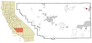
Bear Valley is a census-designated place in Alpine County, California, best known as the location of the Bear Valley ski area. The population was 121 at the 2010 census, down from 133 at the 2000 census.

<span class="mw-page-title-main">Derby Acres, California</span> Census-designated place in California, United States

Derby Acres is a census-designated place (CDP) in Kern County, California, United States. Derby Acres is located 5.5 miles (8.9 km) north-northwest of Fellows, at an elevation of 1,375 feet (419 m). The population was 322 at the 2010 census, down from 376 at the 2000 census. The town is on State Route 33 at the northern extremity of the Midway-Sunset Oil Field, about five miles (8 km)five miles southeast of McKittrick.

<span class="mw-page-title-main">Dustin Acres, California</span> Census-designated place in California, United States

Dustin Acres is a census-designated place (CDP) in Kern County, California, United States. Dustin Acres is located 6.5 miles (10 km) north-northeast of Taft, at an elevation of 384 feet (117 m). The population was 652 at the 2010 census, up from 585 at the 2000 census.

<span class="mw-page-title-main">Valley Acres, California</span> Census-designated place in California, United States

Valley Acres is a census-designated place (CDP) in Kern County, California, United States. Valley Acres is located 5.2 miles (8.4 km) north-northeast of Taft, at an elevation of 420 feet (128.02 m). The population was 527 at the 2010 census, up from 512 at the 2000 census.

<span class="mw-page-title-main">Madera Acres, California</span> Census-designated place in California, United States

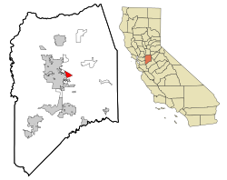
Madera Acres is a census-designated place (CDP) in Madera County, California, United States. It is part of the Madera Metropolitan Statistical Area. The population was 9,162 at the 2020 census, virtually unchanged from 2010.

<span class="mw-page-title-main">Lake Wildwood, California</span> Census-designated place in California, United States

Lake Wildwood is a census-designated place (CDP) in Nevada County, California, United States. The population was 4,991 at the 2010 census, up from 4,868 at the 2000 census.

<span class="mw-page-title-main">Hamilton Branch, California</span> Census-designated place in California, United States

Hamilton Branch is a census-designated place (CDP) in Plumas County, California, United States. The population was 587 at the 2000 census.

<span class="mw-page-title-main">Lake Almanor West, California</span> Census-designated place in California, United States

Lake Almanor West is a census-designated place (CDP) in Plumas County, California, United States. The population was 270 at the 2010 census, down from 329 at the 2000 census.

<span class="mw-page-title-main">Morada, California</span> Census-designated place in California, United States

Morada is a census-designated place (CDP) in San Joaquin County, California, United States. The population was 3,166 at the 2020 census, down from 3,828 at the 2010 census.

<span class="mw-page-title-main">Fruitdale, San Jose</span> Place in California, United States

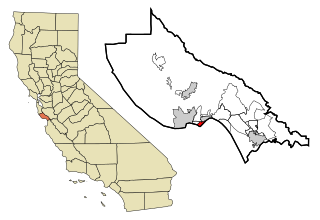
Fruitdale is a district of San Jose, California, located in West San Jose, though some portions are still unincorporated as a census-designated place. The population of the CDP was 935 at the 2010 census.

<span class="mw-page-title-main">Amesti, California</span> Census-designated place in California, United States

Amesti is a census-designated place (CDP) in Santa Cruz County, California, United States. The population was 2,637 as of the 2020 United States census.

<span class="mw-page-title-main">Opal Cliffs, California</span> Unincorporated community in California, United States

Opal Cliffs is an unincorporated community in Santa Cruz County, California, United States.

<span class="mw-page-title-main">Shingletown, California</span> Census-designated place in California, United States

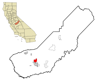
Shingletown is a census-designated place (CDP) in Shasta County, California, United States. Its population is 2,442 as of the 2020 census, up from 2,283 from the 2010 census.

<span class="mw-page-title-main">Terra Bella, California</span> Census-designated place in California, United States

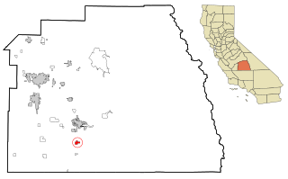
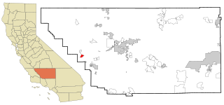
Terra Bella is a census-designated place (CDP) in Tulare County, California, United States. The population was 2,910 at the 2020 census, down from 3,310 at the 2010 census.

<span class="mw-page-title-main">Wahneta, Florida</span> Census-designated place in Florida, United States

Wahneta is a census-designated place (CDP) in central Polk County, Florida, United States. The population was 4,731 at the 2000 census. It is part of the Lakeland–Winter Haven Metropolitan Statistical Area.

<span class="mw-page-title-main">China Lake Acres, California</span> Census-designated place in California, United States

China Lake Acres is a census-designated place (CDP) in Kern County, California, United States. The population was 1,876 at the 2010 census, up from 1,761 at the 2000 census.

<span class="mw-page-title-main">Dent, Ohio</span> Census-designated place in Ohio, United States

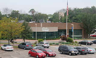
Dent is a census-designated place (CDP) in Green Township, Hamilton County, Ohio, United States. The population was 12,301 at the 2020 census.

<span class="mw-page-title-main">Mount Healthy Heights, Ohio</span> Census-designated place in Ohio, United States

Mount Healthy Heights is a census-designated place (CDP) in Hamilton County, Ohio, United States. The population was 2,918 at the 2020 census.

<span class="mw-page-title-main">Lakeshore Gardens-Hidden Acres, Texas</span> CDP in Texas, United States

Lakeshore Gardens-Hidden Acres is a census-designated place (CDP) in San Patricio County, Texas, United States. The population was 504 at the 2010 census.

<span class="mw-page-title-main">Priest Point, Washington</span> Former CDP in Washington, United States

Priest Point is a former census-designated place (CDP) in Snohomish County, Washington, United States. The population was 779 at the 2000 census. The CDP was discontinued at the 2010 census.

References

  1. "California's 9th Congressional District - Representatives & District Map". Civic Impulse, LLC. Retrieved October 7, 2014.
  2. U.S. Census Archived 2012-07-02 at the Wayback Machine
  3. "Explore Census Data". data.census.gov. Retrieved May 11, 2023.
  4. "US Gazetteer files: 2010, 2000, and 1990". United States Census Bureau. February 12, 2011. Retrieved April 23, 2011.
  5. "Census of Population and Housing". Census.gov. Retrieved June 4, 2016.
  6. "2010 Census Interactive Population Search: CA - Garden Acres CDP". U.S. Census Bureau. Archived from the original on July 15, 2014. Retrieved July 12, 2014.
  7. "U.S. Census website". United States Census Bureau . Retrieved January 31, 2008.