Tracy, California | |
---|---|
Motto: Think Inside the Triangle [1] | |
Coordinates: 37°44′17″N121°26′2″W / 37.73806°N 121.43389°W | |
Country | United States |
State | California |
County | San Joaquin |
Incorporated | July 22, 1910 [2] |
Government | |
• Type | City Manager [3] |
• Mayor | Nancy D. Young [4] |
• Manager | Jennifer D. Haruyama |
• State senator | Susan Eggman (D) [5] |
• Assembly member | Carlos Villapudua (D) [5] |
• U. S. rep. | Mark DeSaulnier (D) [6] |
Area | |
• Total | 26.03 sq mi (67.42 km2) |
• Land | 25.90 sq mi (67.07 km2) |
• Water | 0.14 sq mi (0.35 km2) 0.61% |
Elevation | 52 ft (16 m) |
Population | |
• Total | 93,000 |
• Rank | 84th in California |
• Density | 3,600/sq mi (1,400/km2) |
Time zone | UTC−8 (Pacific) |
• Summer (DST) | UTC−7 (PDT) |
ZIP codes | 95304, 95376–95378, 95385, 95391 |
Area code | 209 |
FIPS code | 06-80238 |
GNIS feature IDs | 277621, 2412090 |
Website | cityoftracy |
Tracy is the second most populated city in San Joaquin County, California, United States. The population was 93,000 at the 2020 census. Tracy is located inside a geographic triangle formed by Interstate 205 on the north side of the city, Interstate 5 to the east, and Interstate 580 to the southwest.
Until the 1760s, the area that became the city of Tracy was long populated by the Yokuts ethnic group of loosely associated bands of Native Americans and their ancestors. They lived on hunting and gathering game and fish from local rivers and creeks. After encountering the Spanish colonists, the Yokuts suffered from new infectious diseases, which caused social disruption, as did the Spanish efforts to impress them into labor at Mission San José. Mexican and American explorers later arrived, pushing the Yokuts out. [10] The Yokuts people remain, living in small groups with about 2,600 people identifying as Yokut. Along with them, another language group of Native Americans found near Tracy are referred to as the Mono people, numbering around 1,800. [11]
Tracy is a railroad town that came from the mid-19th century construction, mainly by Chinese laborers, of Central Pacific Railroad rail lines running from Sacramento through Stockton to the San Francisco Bay Area, beginning 1868 and ending September 1878 with the opening of a new branch and junction. [12] A number of small communities sprang up along these lines at designated station sites, including one at the junction named for railroad director J. J. Tracy. [13]
Incorporated in 1911, Tracy grew rapidly and prospered as the center of an agricultural area, even when larger railroad operations began to decline in the 1950s. Competition with trucking and automobiles resulted in widespread railroad restructuring. Tracy is part of the San Jose-San Francisco-Oakland, CA Combined Statistical Area, an extension of the Bay Area.
In December 1969, the town of Tracy hosted the Altamont Free Concert, held at the later closed Altamont Raceway Park. An estimated 300,000 people gathered at the speedway infield in an event that was plagued by violence among attendees, many of whom were drunk or drugged. Artists featured included the British Rolling Stones and the California bands Santana, Jefferson Airplane, the Flying Burrito Brothers and Crosby, Stills, Nash & Young.
Tracy was the headquarters of a branch of the American Nazi Party. Increased activity was reported by the media in 1972, with the appearance of graffiti spray-painted Nazi swastikas and the words "White Power". A surplus army 2½-ton 6×6 truck with swastika symbols was seen carrying neo-Nazi recruits around town. Members handed out flyers printed with "Join the National Socialist White People’s Party" and a Tracy-based post office box mailing address. The television program 60 Minutes aired a report in 1978 titled "The California Reich" with an interview of a Tracy resident who was a neo-Nazi leader. After about a decade, most of the city's neo-Nazis moved to Oroville, California. [14]
Located in the Central Valley, Tracy is near both fertile and (due to a region of hills west of Tracy) infertile agricultural lands. Tracy has a Mediterranean climate.
Some of this land (in the east and mostly north of Tracy because of the moist Delta river system) has come under increasing development pressure. The San Francisco Bay Area's vigorous population growth has spilled over into the Tracy area as well as other locations, such as the new town of Mountain House. Tracy passed Measure A in 1990 in an attempt to contain and limit development.
In an effort to reduce environmental impacts of the city, it launched the Emerald Tracy Project in September 2009. City spokesman Matt Robinson said that if it succeeds, Tracy will be the second city after Riverside, California to satisfy the state's goal for sustainable communities.
On August 7, 1998, a tire fire ignited at S.F. Royster's Tire Disposal south of Tracy at 29425 South MacArthur Drive, near Linne Road. The tire dump held more than 7 million illegally stored tires and was allowed to burn for over two years before it was extinguished. Allowing the fire to burn was considered to be a better way to avoid groundwater contamination than putting it out. [15] The cleanup of chemicals released by the fire cost $16.2 million. The chemicals were found to have contaminated groundwater in the region. [16] [17]
Tracy is marked by a semi-arid climate (Köppen BSh), with cool, moist winters and very hot and dry summers, displaying Mediterranean characteristics. December and January are the coolest months, and average around 47.1 °F (8.4 °C), and there are 19 nights with lows at or below freezing annually, with the coldest night of the year typically bottoming out below 30 °F (−1.1 °C). [18] July is the warmest month, averaging 76.4 °F (28.3 °C); normally, there are 18 days of 100 °F (37.8 °C)+ highs and 82 days of 90 °F (32.2 °C)+ highs. Average annual precipitation is around 12.5 inches (317.7 mm), which, by definition, results in the area being classified as a semi-desert.
Climate data for Tracy Pumping Plant (1991–2020 normals, extremes 1955–present) | |||||||||||||
---|---|---|---|---|---|---|---|---|---|---|---|---|---|
Month | Jan | Feb | Mar | Apr | May | Jun | Jul | Aug | Sep | Oct | Nov | Dec | Year |
Record high °F (°C) | 74 (23) | 77 (25) | 88 (31) | 97 (36) | 107 (42) | 112 (44) | 112 (44) | 111 (44) | 112 (44) | 102 (39) | 85 (29) | 74 (23) | 112 (44) |
Mean daily maximum °F (°C) | 56.3 (13.5) | 61.9 (16.6) | 67.4 (19.7) | 73.2 (22.9) | 80.2 (26.8) | 88.1 (31.2) | 93.3 (34.1) | 92.5 (33.6) | 88.8 (31.6) | 79.1 (26.2) | 65.6 (18.7) | 56.6 (13.7) | 75.2 (24.0) |
Daily mean °F (°C) | 48.4 (9.1) | 52.8 (11.6) | 57.2 (14.0) | 61.7 (16.5) | 67.7 (19.8) | 73.7 (23.2) | 77.6 (25.3) | 77.2 (25.1) | 74.5 (23.6) | 66.8 (19.3) | 55.9 (13.3) | 48.5 (9.2) | 63.5 (17.5) |
Mean daily minimum °F (°C) | 40.5 (4.7) | 43.7 (6.5) | 47.0 (8.3) | 50.2 (10.1) | 55.2 (12.9) | 59.4 (15.2) | 61.9 (16.6) | 61.9 (16.6) | 60.2 (15.7) | 54.5 (12.5) | 46.1 (7.8) | 40.3 (4.6) | 51.7 (10.9) |
Record low °F (°C) | 18 (−8) | 23 (−5) | 25 (−4) | 29 (−2) | 34 (1) | 37 (3) | 44 (7) | 42 (6) | 40 (4) | 30 (−1) | 24 (−4) | 17 (−8) | 17 (−8) |
Average precipitation inches (mm) | 2.51 (64) | 2.32 (59) | 1.60 (41) | 0.84 (21) | 0.52 (13) | 0.13 (3.3) | 0.00 (0.00) | 0.01 (0.25) | 0.08 (2.0) | 0.67 (17) | 1.32 (34) | 2.37 (60) | 12.37 (314) |
Average snowfall inches (cm) | 0.0 (0.0) | 0.0 (0.0) | 0.0 (0.0) | 0.0 (0.0) | 0.0 (0.0) | 0.0 (0.0) | 0.0 (0.0) | 0.0 (0.0) | 0.0 (0.0) | 0.0 (0.0) | 0.0 (0.0) | 0.0 (0.0) | 0.0 (0.0) |
Average precipitation days (≥ 0.01 in) | 12.9 | 9.6 | 8.4 | 4.8 | 2.7 | 0.9 | 0.0 | 0.3 | 0.5 | 2.5 | 6.7 | 11.8 | 61.1 |
Average snowy days (≥ 0.1 in) | 0.0 | 0.0 | 0.0 | 0.0 | 0.0 | 0.0 | 0.0 | 0.0 | 0.0 | 0.0 | 0.0 | 0.0 | 0.0 |
Source: NOAA [19] [20] |
Census | Pop. | Note | %± |
---|---|---|---|
1930 | 3,829 | — | |
1940 | 4,056 | 5.9% | |
1950 | 8,410 | 107.3% | |
1960 | 11,289 | 34.2% | |
1970 | 14,724 | 30.4% | |
1980 | 18,428 | 25.2% | |
1990 | 33,558 | 82.1% | |
2000 | 56,929 | 69.6% | |
2010 | 82,922 | 45.7% | |
2020 | 93,000 | 12.2% | |
U.S. Decennial Census [21] |
Race / Ethnicity (NH = Non-Hispanic) | Pop 2000 [22] | Pop 2010 [23] | Pop 2020 [24] | % 2000 | % 2010 | % 2020 |
---|---|---|---|---|---|---|
White alone (NH) | 30,723 | 30,005 | 25,117 | 53.97% | 36.18% | 27.01% |
Black or African American alone (NH) | 2,976 | 5,636 | 5,737 | 5.23% | 6.80% | 6.17% |
Native American or Alaska Native alone (NH) | 297 | 297 | 310 | 0.52% | 0.36% | 0.33% |
Asian alone (NH) | 4,481 | 11,803 | 19,339 | 7.87% | 14.23% | 20.79% |
Pacific Islander alone (NH) | 275 | 641 | 897 | 0.48% | 0.77% | 0.96% |
Other race alone (NH) | 182 | 223 | 634 | 0.32% | 0.27% | 0.68% |
Mixed race or Multiracial (NH) | 2,230 | 3,760 | 4,969 | 3.92% | 4.53% | 5.34% |
Hispanic or Latino (any race) | 15,765 | 30,557 | 35,997 | 27.69% | 36.85% | 38.71% |
Total | 56,929 | 82,922 | 93,000 | 100.00% | 100.00% | 100.00% |
The 2010 United States Census [25] reported that Tracy had a population of 82,922. The population density was 3,745.5 inhabitants per square mile (1,446.1/km2). The racial makeup of Tracy was 43,724 (52.7%) White, 5,953 (7.2%) African American, 715 (0.9%) Native American, 12,229 (14.7%) Asian, 747 (0.9%) Pacific Islander, 13,173 (15.9%) from other races, and 6,381 (7.7%) from two or more races. Hispanic or Latino of any race were 30,557 persons (36.9%).
The Census reported that 82,606 people (99.6% of the population) lived in households, 69 (0.1%) lived in non-institutionalized group quarters, and 247 (0.3%) were institutionalized.
There were 24,331 households, out of which 13,143 (54.0%) had children under the age of 18 living in them, 15,122 (62.2%) were opposite-sex married couples living together, 3,196 (13.1%) had a female householder with no husband present, and 1,627 (6.7%) had a male householder with no wife present. There were 1,501 (6.2%) unmarried opposite-sex partnerships, and 184 (0.8%) same-sex married couples or partnerships. 3,326 households (13.7%) were made up of individuals, and 1,026 (4.2%) had someone living alone who was 65 years of age or older. The average household size was 3.40. There were 19,945 families (82.0% of all households); the average family size was 3.72.
The population was spread out, with 26,668 people (32.2%) under the age of 18, 7,476 people (9.0%) aged 18 to 24, 23,826 people (28.7%) aged 25 to 44, 19,202 people (23.2%) aged 45 to 64, and 5,750 people (6.9%) who were 65 years of age or older. The median age was 32.3 years. For every 100 females, there were 98.3 males. For every 100 females age 18 and over, there were 94.9 males.
There were 25,963 housing units at an average density of 1,172.7 per square mile (452.8/km2), of which 16,163 (66.4%) were owner-occupied, and 8,168 (33.6%) were occupied by renters. The homeowner vacancy rate was 2.5%; the rental vacancy rate was 5.9%. 54,275 people (65.5% of the population) lived in owner-occupied housing units and 28,331 people (34.2%) lived in rental housing units.
Tracy City Hall and Jail was first commissioned by the city in November–December 1899 and completed in March 1900 after the original Jail and city hall was burnt down. This historical site served as the local governments place of operation during Tracy's formative years, which makes this building an integral part of Tracy's foundation. The structure is made of a simple brick building that is 24 by 43 feet in dimension located on 25 West Seventh Street, and was built by J.F. Hoerl. In the historical resources inventory, the Tracy City Hall and Jail was one of only fourteen buildings to receive and "exceptional" rating. [26]
The Tracy Inn was originally opened in 1927 with a total of 60 rooms on the second floor and is still located on 24 West Eleventh Street. The building has a very transitional architectural style befitting the 1920s with a classic Spanish Colonial revival and modern styles mixed together. The building was designed by the Oakland firm of Slocomhe and Tuttle. In 1949, after the ownership changed, the Tracy Inn suffered with a fire that burned the only original blue prints of the building. Even with this loss the owner was still able to recreate the original look of the Tracy Inn. The iconic sign of the Tracy Inn has also been replaced in 1945. [27]
The United States Postal Service operates the Tracy Post Office [28] and the Tracy Carrier Annex. [29]
The California Department of Corrections and Rehabilitation operates the Deuel Vocational Institution, a state prison, in unincorporated San Joaquin County, near Tracy.
The Tracy Defense Distribution Depot began its operations back in 1942, and has since been a main supply for American troops for all major wars since World War II. The distribution depot has around 30 warehouses and is a major employer for the area, just under Safeway. [30]
Three public school districts serve the city of Tracy. The largest and most recognized is the Tracy Unified School District. This school system incorporates many elementary and middle schools as well as five Tracy high schools: Tracy High School, Merrill F. West High School, Delta Charter High School, Millennium Charter High School and John C. Kimball High School.
Tracy's students with behavioral issues attend the Willow Community Day School, and the Tracy One Program, or Community One. The other two school districts are: Lammersville Joint Unified School District, which includes six K-8 schools (Peter Hansen Elementary, Julius Cordes Elementary, Wicklund Elementary, Bethany Elementary, Questa Elementary, and Altamont Elementary) along with Mountain House High School, which was opened in 2014. and Jefferson School District. The latter covers the south side of Tracy and includes four schools: Jefferson Middle School, Tom Hawkins Elementary School, Monticello Elementary School and Anthony C. Traina School.
Tracy's daily newspaper is the Tracy Press , a once-weekly newspaper. Bilingual Weekly News covers Tracy in English and Spanish.
Tracy is served by several bus services: locally, Tracer runs seven lines that serve as circulators between major transit hubs, shopping, school, residential, and downtown areas. San Joaquin Regional Transit District (SJRTD) runs two county hopper routes that connect the city with other San Joaquin County communities and one commuter route that runs to Dublin/Pleasanton BART station.
Greyhound, Tracer, and SJRTD all connect with taxis, bike stations, and parking at the Tracy Transit Center, a transit station built in 2010. Amtrak Thruway buses serve the city's bus station to connect the area with six daily trips to the South Bay and two to San Francisco, all of which stop at BART and job centers in Livermore.
South Tracy offers the Altamont Corridor Express (ACE) service at Tracy (ACE station), which provides commuter rail transportation to the Bay Area and connects with VTA in San Jose, BART via shuttle in Pleasanton and Fremont, in addition to Amtrak train in Santa Clara and San Jose. Valley Link is planned to pass through Tracy and provide a passenger rail service connecting directly to BART. Intercity passenger rail service to Tracy ended in 1971 with the formation of Amtrak. [31]
Interstate 205 passes along the north side of the city and connects the nearby Interstates 580 to the west and 5 on the east, with the three Interstates forming a triangle around much of the city. Business Loop 205 runs through the center of Tracy along 11th Street, formerly a portion of U.S. Highway 50. In addition, the northern terminus of State Highway 33 is located at South Bird Road and Interstate 5 southeast of Tracy.
Tracy is served by Tracy Municipal Airport, located south of the city. It serves general aviation; there is no scheduled airline service from the airport.
Tracy has been a sister city of Memuro, Hokkaido since 1989. The city is also a sister city of Velas in the Azores. [49]
Alameda County is a county located in the U.S. state of California. As of the 2020 census, the population was 1,682,353, making it the 7th-most populous county in the state and 21st most populous nationally. The county seat is Oakland. Alameda County is in the San Francisco Bay Area, occupying much of the East Bay region.
Fresno County, officially the County of Fresno, is a county located in the central portion of the U.S. state of California. As of the 2020 Census, the population was 1,008,654. The county seat is Fresno, the fifth-most populous city in California.
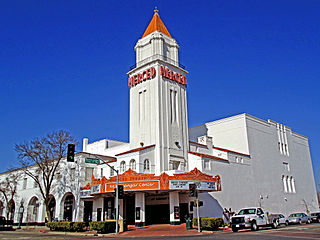
Merced County, is a county located in the northern San Joaquin Valley section of the Central Valley, in the U.S. state of California.
San Joaquin County, officially the County of San Joaquin, is a county located in the U.S. state of California. As of the 2020 census, the population was 779,233. The county seat is Stockton.
Stanislaus County is a county located in the San Joaquin Valley of the U.S. state of California. As of 2023, its estimated population is 564,404. The county seat is Modesto.
Fresno is a major city in the San Joaquin Valley of California, United States. It is the county seat of Fresno County and the largest city in the greater Central Valley region. It covers about 115 square miles (300 km2) and had a population of 542,107 as of the 2020 Census, making it the fifth-most populous city, in California, the most populous inland city in California, and the 34th-most populous city in the nation.
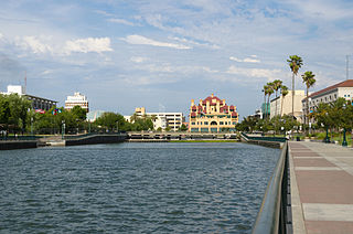
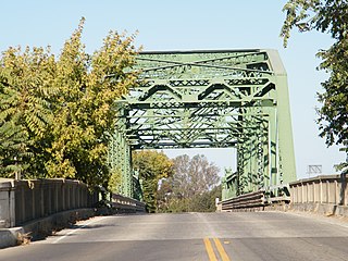
Stockton is a city in and the county seat of San Joaquin County in the Central Valley of the U.S. state of California. Stockton is the most populous city in the county, the 11th-most populous city in California and the 58th-most populous city in the United States. Stockton's population in 2020 was 320,804. It was named an All-America City in 1999, 2004, 2015, and again in 2017 and 2018. The city is located on the San Joaquin River in the northern San Joaquin Valley. It lies at the southeastern corner of a large inland river delta that isolates it from other nearby cities such as Sacramento and those of the San Francisco Bay Area.
Livermore is a city in Alameda County, California. With a 2020 population of 87,955, Livermore is the most populous city in the Tri-Valley, giving its name to the Livermore Valley. It is located on the eastern edge of California's San Francisco Bay Area, making it the easternmost city in the area. The current mayor is John Marchand.
Union City is a city in Alameda County, California, United States in the San Francisco Bay Area. It is located approximately 19 miles (31 km) south of Oakland, 30 miles (48 km) from San Francisco, and 20 miles (32 km) north of San Jose. It was incorporated in 1959, combining the communities of Alvarado and Decoto. The city has 72,000 residents across a diverse population. Alvarado is a California Historical Landmark (#503). The city celebrated its 50th anniversary in 2009.
Moraga is a town in Contra Costa County, California, in the San Francisco Bay Area. The town is named in honor of Joaquín Moraga, member of the famed Californio family. As of 2020, Moraga had a total population of 16,870 people. Moraga is the home of Saint Mary's College of California.
Pittsburg is a city in Contra Costa County, California, United States. It is an industrial suburb located on the southern shore of the Suisun Bay in the East Bay region of the San Francisco Bay Area, and is part of the Sacramento–San Joaquin River Delta area, the Eastern Contra Costa County area, and the San Francisco Bay Area. The population was 76,416 at the 2020 United States Census.
Bakersfield is a city in and the county seat of Kern County, California, United States. The city covers about 151 sq mi (390 km2) near the southern end of the San Joaquin Valley, which is located in the Central Valley region.
San Juan Capistrano is a city in southern Orange County, California, United States. The population was 35,253 at the 2020 Census.
Lathrop is a city located 10 miles (16 km) south of Stockton in San Joaquin County, California, United States. The 2020 census reported that Lathrop's population was 28,701. The city is located in Northern California at the intersection of Interstate 5 and California State Route 120, in the San Joaquin Valley.
Manteca is a city in San Joaquin County, California. The city had a population of 83,498 as of the 2020 Census. It is part of the Stockton-Lodi, CA Metropolitan Statistical Area.
Ripon is a city located in San Joaquin County, California. The population was 14,297 at the 2010 census. Ripon was originally known as Stanislaus City, but was renamed for Ripon, Wisconsin, in 1876.
Exeter is a city in Tulare County, California, United States. It is situated in the San Joaquin Valley near the foothills of the Sierra Nevada. The population was 10,321 at the 2020 census, down from 10,334 at the 2010 census.
Altamont Pass, formerly Livermore Pass, is a low mountain pass in the Diablo Range of Northern California between Livermore in the Livermore Valley and Tracy in the San Joaquin Valley. The name is actually applied to two distinct but nearby crossings of the range. The lower of the two, at an elevation of 741 ft (226 m), carries two railroad rights-of-way (ROWs) and Altamont Pass Road, part of the old Lincoln Highway and the original alignment of US 50 before it was bypassed in 1937. The bypass route travels over the higher summit, at 1,009 ft (308 m), and now carries Interstate 580, a major regional highway heavily congested by Central Valley suburbanization.
Mountain House is a planned community and census-designated place in San Joaquin County, California, United States.
Valley Link is a proposed 26-mile-long (42 km) commuter rail service in Northern California, which seeks to connect the rapid transit Bay Area Rapid Transit (BART) system in the San Francisco Bay Area with the northern San Joaquin Valley via the Tri-Valley region. Since 1997, BART's Blue Line's eastern terminus is at Dublin/Pleasanton station on the border of Dublin and Pleasanton. Valley Link seeks to extend rail service east from here into the northern San Joaquin Valley over Altamont Pass and to help alleviate traffic congestion and reducing greenhouse gas emissions on Interstate 580 (I-580). The project resulted from various failed proposals to extend the Blue Line east to Livermore.
Tide Level Branch of the Central Pacific Railroad, between Oakland and Sacramento, will be started into operation about the 1st of September. This route leaves the Western Division at Tracey, a new station located about half-way between Ellis and Bantas; thence it runs to Martinez, and follows the edge of San Pablo and San Francisco bays to Oakland wharf. Ellis Station will be abandoned after Sunday, September 1, and all the buildings at that point are to be moved up to Tracey. ... Sacramento Bee
{{cite book}}
: |work=
ignored (help){{cite web}}
: CS1 maint: multiple names: authors list (link){{cite web}}
: CS1 maint: multiple names: authors list (link)