Related Research Articles

Sacramento County is a county located in the U.S. state of California. As of the 2020 census, the population was 1,585,055. Its county seat is Sacramento, which has been the state capital of California since 1854.

Klamath County was a county of California from 1851 to 1874. During its existence, the county seat moved twice and ultimately portions of the territory it once had were carved up and added to nearby counties. It was formed from the northwestern portion of Trinity County, and originally included all of the northwestern part of the state, from the Mad River in the south to Oregon in the north, from the Pacific Ocean in the west to the middle of what is now Siskiyou County in the east. It is the only county in California to be disestablished.

The Cosumnes River is a river in northern California in the United States. It rises on the western slope of the Sierra Nevada and flows approximately 52.5 miles (84.5 km) into the Central Valley, emptying into the Mokelumne River in the Sacramento-San Joaquin Delta.

The Mokelumne River is a 95-mile (153 km)-long river in northern California in the United States. The river flows west from a rugged portion of the central Sierra Nevada into the Central Valley and ultimately the Sacramento–San Joaquin River Delta, where it empties into the San Joaquin River-Stockton Deepwater Shipping Channel. Together with its main tributary, the Cosumnes River, the Mokelumne drains 2,143 square miles (5,550 km2) in parts of five California counties. Measured to its farthest source at the head of the North Fork, the river stretches for 157 miles (253 km).

The Plains and Sierra Miwok were once the largest group of California Indian Miwok people, indigenous to California. Their homeland included regions of the Sacramento Valley, San Joaquin Valley, and the Sierra Nevada.
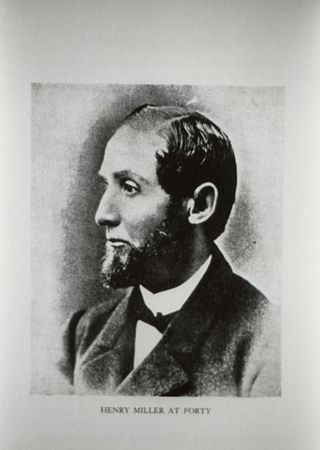
Henry Miller was a German-American rancher known as the "Cattle King of California" who at one point in the late 19th century was one of the largest land-owners in the United States.

Salmon Falls is a former settlement in El Dorado County, California. It was located on the South Fork of the American River 5.5 miles (9 km) south-southwest of Pilot Hill, at an elevation of 469 feet. It was flooded by Folsom Lake. Nearby were waterfalls from which the place got its name. The site is now registered as California Historical Landmark #571.
Rancho Johnson was a 22,197-acre (89.83 km2) Mexican land grant in present-day Yuba County, California, given in 1844 by Governor Manuel Micheltorena to Pablo Gutiérrez. The grant was located along the north side of Bear River, and encompassed present-day Wheatland.
Georgiana Slough, is a slough within Sacramento County, California. It is located in the Sacramento–San Joaquin River Delta, and links both the Sacramento River and the San Joaquin River above their confluence in the Delta near Pittsburg, at the head of Suisun Bay, through its connection with the Mokelumne River. The entrance to the slough on the Sacramento River is just below Walnut Grove, at 38°14′21″N121°30′59″W and runs between Tyler Island and Andrus Island to where it has its confluence with the Mokelumne River at 38°07′49″N121°34′40″W northwest of Bouldin Island just above that rivers confluence with the San Joaquin River.

Visalia, California, commonly known in the 1850s as Four Creeks, is the oldest continuously inhabited inland European settlement between Stockton and Los Angeles. The city played an important role in the American colonization of the San Joaquin Valley as the county seat of Old Tulare County, an expansive region comprising most if not all of modern-day Fresno, Kings, and Kern counties.
Poverty Bar is a former settlement in Calaveras County, California, active from c. 1850s to 1862, and now covered by the waters of Camanche Reservoir. The nearest major town is Campo Seco, California.
Rancho Cosumnes was a 26,605-acre (107.67 km2) Mexican land grant in present-day Sacramento County, California given in 1844 by Governor Manuel Micheltorena to William Edward Petty Hartnell. The grant extended along the south bank of the Cosumnes River, across from Rancho Omochumnes.
Rancho Omochumnes, also known as "Rancho Río de los Cosumnes al Norte", was a 18,662-acre (75.52 km2) Mexican land grant in present day Sacramento County, California.
Rancho Sanjon de los Moquelumnes was a 35,508-acre (143.70 km2) Mexican land grant in present-day Sacramento County and San Joaquin County, California given in 1844 by Governor Manuel Micheltorena to Anastasio Chaboya. Sanjon is Spanish for ditch or deep slough. The grant stretched from the Cosumnes River on the north to the Mokelumne River on the south, and encompassed present-day Galt.
Gullion's Bar was a placer gold mining camp on the Salmon River, now located in Siskiyou County, California. It was located originally in Trinity County, in 1850.
Georgiana, a small side-wheel steamboat made in Philadelphia in 1849, one of the first on the waters of the Mokelumne River, Sacramento, San Joaquin and Tuolumne Rivers of California.
Steamboats operated in California on San Francisco Bay and the Sacramento–San Joaquin River Delta, and Sacramento River as early as November 1847, when the Sitka built by William A. Leidesdorff briefly ran on San Francisco Bay and up the Sacramento River to New Helvetia. After the first discovery of gold in California the first shipping on the bays and up the rivers were by ocean going craft that were able to sail close to the wind and of a shallow enough draft to be able to sail up the river channels and sloughs, although they were often abandoned by their crews upon reaching their destination. Regular service up the rivers, was provided primarily by schooners and launches to Sacramento and Stockton, that would take a week or more to make the trip.
Dutton Island is a small island in Suisun Bay, California. It is part of Solano County, and included within Reclamation District 2127. Its coordinates are 38°04′54″N121°58′14″W. An 1850 survey map of the San Francisco Bay area made by Cadwalader Ringgold, as well as an 1854 map of the area by Henry Lange, shows an unlabeled island covering some of the area now occupied by Dutton Island.

Wheeler Island is a small island in Suisun Bay, California. It is part of Solano County; parts of it are included in Reclamation Districts 2127 and 2130. Its coordinates are 38°05′06″N121°56′15″W. An 1850 survey map of the San Francisco Bay area made by Cadwalader Ringgold, and an 1854 map by Henry Lange, show islands partially covering some of the current area of Wheeler Island, labeled "Davis Island" and "Warrington Island".
Spinner Island is an island in Suisun Bay, an embayment of San Francisco Bay, downstream of the Sacramento–San Joaquin River Delta. It is part of Solano County, California, and not managed by any reclamation district. Its coordinates are 38°04′11″N121°52′10″W, and the United States Geological Survey measured its elevation as 0 ft (0 m) in 1981. It is shown in an 1850 survey map of the San Francisco Bay area made by Cadwalader Ringgold, as well as an 1854 map of the area by Henry Lange.
References
- ↑ "Mokelumne City". Office of Historic Preservation, California State Parks. Retrieved 2012-10-14.
- ↑ Hubert Howe Bancroft, History of California: 1848-1859, The History Company, San Francisco, 1888, p.513 note (Pac News, May 2, Aug. 28, 1850.)
- ↑ Bancroft, History of California: 1848-1859, p.513 note
