Lincoln Village, California

Last updated

Lincoln Village
San Joaquin County California Incorporated and Unincorporated areas Lincoln Village Highlighted.svg
Location in San Joaquin County and the state of California
Usa edcp location map.svg
Red pog.svg
Lincoln Village
Location in the United States
Coordinates: 38°0′15″N121°20′4″W / 38.00417°N 121.33444°W / 38.00417; -121.33444
Country Flag of the United States (23px).png  United States
State Flag of California.svg  California
County San Joaquin
Government
   Senate Lois Wolk (D)
   Assembly Alan Nakanishi (R)
   U. S. Congress Josh Harder (D) [1]
Area
[2]
  Total0.736 sq mi (1.906 km2)
  Land0.736 sq mi (1.906 km2)
  Water0 sq mi (0 km2)  0%
Elevation
13 ft (4 m)
Population
 (2020) [3]
  Total4,401
  Density6,000/sq mi (2,300/km2)
Time zone UTC-8 (PST)
  Summer (DST) UTC-7 (PDT)
ZIP code
95207
Area code 209
FIPS code 06-41558
GNIS feature ID1658962

Lincoln Village is a census-designated place (CDP) in San Joaquin County, California, United States. The population was 4,381 at the 2010 census, up from 4,216 at the 2000 census.

Contents

Geography

Lincoln Village is located at 38°0′15″N121°20′4″W / 38.00417°N 121.33444°W / 38.00417; -121.33444 (38.004122, -121.334544). [4]

According to the United States Census Bureau, the CDP has a total area of 0.7 square miles (1.8 km2), all of it land.

Climate

According to the Köppen Climate Classification system, Lincoln Village has a warm-summer Mediterranean climate, abbreviated "Csa" on climate maps. [5]

Demographics

Historical population
CensusPop.Note
U.S. Decennial Census [6]

2010

The 2010 United States Census [7] reported that Lincoln Village had a population of 4,381. The population density was 5,952.8 inhabitants per square mile (2,298.4/km2). The racial makeup of Lincoln Village was 2,971 (67.8%) White, 154 (3.5%) African American, 58 (1.3%) Native American, 269 (6.1%) Asian, 13 (0.3%) Pacific Islander, 536 (12.2%) from other races, and 380 (8.7%) from two or more races. Hispanic or Latino of any race were 1,422 persons (32.5%).

The Census reported that 4,371 people (99.8% of the population) lived in households, 10 (0.2%) lived in non-institutionalized group quarters, and 0 (0%) were institutionalized.

There were 1,565 households, out of which 613 (39.2%) had children under the age of 18 living in them, 750 (47.9%) were opposite-sex married couples living together, 291 (18.6%) had a female householder with no husband present, 101 (6.5%) had a male householder with no wife present. There were 113 (7.2%) unmarried opposite-sex partnerships, and 9 (0.6%) same-sex married couples or partnerships. 329 households (21.0%) were made up of individuals, and 149 (9.5%) had someone living alone who was 65 years of age or older. The average household size was 2.79. There were 1,142 families (73.0% of all households); the average family size was 3.25.

The population was spread out, with 1,224 people (27.9%) under the age of 18, 402 people (9.2%) aged 18 to 24, 1,060 people (24.2%) aged 25 to 44, 1,088 people (24.8%) aged 45 to 64, and 607 people (13.9%) who were 65 years of age or older. The median age was 36.2 years. For every 100 females, there were 90.9 males. For every 100 females age 18 and over, there were 86.9 males.

There were 1,671 housing units at an average density of 2,270.5 per square mile (876.6/km2), of which 1,095 (70.0%) were owner-occupied, and 470 (30.0%) were occupied by renters. The homeowner vacancy rate was 2.1%; the rental vacancy rate was 10.6%. 2,807 people (64.1% of the population) lived in owner-occupied housing units and 1,564 people (35.7%) lived in rental housing units.

2000

As of the census [8] of 2000, there were 4,216 people, 1,569 households, and 1,168 families residing in the CDP. The population density was 5,747.9 inhabitants per square mile (2,219.3/km2). There were 1,615 housing units at an average density of 2,201.8 per square mile (850.1/km2). The racial makeup of the CDP was 79.32% White, 2.92% African American, 1.04% Native American, 4.27% Asian, 0.02% Pacific Islander, 6.74% from other races, and 5.69% from two or more races. Hispanic or Latino of any race were 19.00% of the population.

There were 1,569 households, out of which 35.9% had children under the age of 18 living with them, 52.1% were married couples living together, 18.0% had a female householder with no husband present, and 25.5% were non-families. 21.8% of all households were made up of individuals, and 11.0% had someone living alone who was 65 years of age or older. The average household size was 2.69 and the average family size was 3.12.

In the CDP, the population was spread out, with 29.0% under the age of 18, 6.9% from 18 to 24, 26.6% from 25 to 44, 21.5% from 45 to 64, and 16.1% who were 65 years of age or older. The median age was 37 years. For every 100 females, there were 87.6 males. For every 100 females age 18 and over, there were 81.4 males.

The median income for a household in the CDP was $49,940, and the median income for a family was $55,402. Males had a median income of $40,000 versus $30,673 for females. The per capita income for the CDP was $22,115. About 7.3% of families and 8.4% of the population were below the poverty line, including 15.3% of those under age 18 and 1.0% of those age 65 or over.

Lance McHan Realtor helping families in Lincoln Village. 209-986-9292

Related Research Articles

<span class="mw-page-title-main">Alpine Village, California</span> Census-designated place in California, United States

Alpine Village is a census-designated place (CDP) in Alpine County, California, United States. The population was 114 at the 2010 census, down from 136 at the 2000 census.

<span class="mw-page-title-main">Oroville East, California</span> Census-designated place in California, United States

Oroville East or Kelly Ridge is a census-designated place (CDP) in Butte County, California, United States. The population was 8,280 at the 2010 census, down from 8,680 at the 2000 census. Most citizens are dependent on the commerce of Oroville, and the vast majority of high school students in Kelly Ridge attend Las Plumas High School. The community of Kelly Ridge sits at Lake Oroville and offers direct access to boating, camping, fishing and a variety of water sports.

<span class="mw-page-title-main">Hamilton Branch, California</span> Census-designated place in California, United States

Hamilton Branch is a census-designated place (CDP) in Plumas County, California, United States. The population was 587 at the 2000 census.

<span class="mw-page-title-main">Lake Almanor Country Club, California</span> Census-designated place in California, United States

Lake Almanor Country Club is a census-designated place (CDP) in Plumas County, California, United States. The population was 419 at the 2010 census, down from 847 at the 2000 census. The ZIP code for the CDP is 96137.

<span class="mw-page-title-main">Prattville, California</span> Census-designated place in California, United States

Prattville is a census-designated place (CDP) in Plumas County, California, United States. The population was 24 at the 2020 census, down from 33 at the 2000 census.

<span class="mw-page-title-main">La Riviera, California</span> Census-designated place in California, United States

La Riviera is a census-designated place (CDP) in Sacramento County, California, United States. It is part of the Sacramento–Arden-Arcade–Roseville Metropolitan Statistical Area. The population was 10,802 at the 2010 census, up from 10,273 at the 2000 census. La Riviera is a primarily residential neighborhood located between the American River on the North side and Highway 50 on the southern border.

<span class="mw-page-title-main">Garden Acres, California</span> Census-designated place in California, United States

Garden Acres is a census-designated place (CDP) in San Joaquin County, California, United States. The population was 10,648 at the 2010 census, up from 9,747 at the 2000 census. It is the most populous CDP in San Joaquin County.

<span class="mw-page-title-main">Morada, California</span> Census-designated place in California, United States

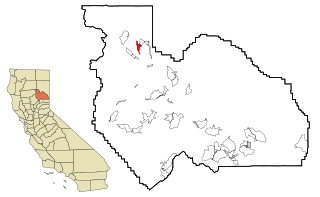
Morada is a census-designated place (CDP) in San Joaquin County, California, United States. The population was 3,166 at the 2020 census, down from 3,828 at the 2010 census.

<span class="mw-page-title-main">Nassau Village-Ratliff, Florida</span> CDP in Florida, United States

Nassau Village-Ratliff is a census-designated place (CDP) in Nassau County, Florida, United States. The population was 5,337 at the 2010 census.

<span class="mw-page-title-main">Conway, Florida</span> Census-designated place in Florida, United States

Conway is a census-designated place and an unincorporated area in Orange County, Florida, United States. The population was 13,467 at the 2010 census. It is part of the Orlando–Kissimmee–Sanford, Florida Metropolitan Statistical Area.

<span class="mw-page-title-main">North Westport, Massachusetts</span> Census-designated place in Massachusetts, United States

North Westport is a census-designated place (CDP) in the town of Westport in Bristol County, Massachusetts, United States. The population was 4,571 at the 2010 census.

<span class="mw-page-title-main">Lakeland Village, California</span> Census-designated place in California, United States

Lakeland Village is a census-designated place (CDP) in Riverside County, California, United States. The population was 11,541 at the 2010 census, more than double the 5,626 reported at the 2000 census.

<span class="mw-page-title-main">East Porterville, California</span> Place in California, United States

East Porterville is an unincorporated community in Tulare County, California, United States. Adjacent to the city of Porterville, the community lies by the Sierra Nevada foothills. The population was 7,331 at the 2010 census, up from 6,730 at the 2000 census. For statistical purposes, the United States Census Bureau has defined East Porterville as a census-designated place (CDP). The census definition of the area may not precisely correspond to local understanding of the area with the same name.

<span class="mw-page-title-main">Millersburg, Michigan</span> Village in Michigan, United States

Millersburg is a village in Presque Isle County of the U.S. state of Michigan. The population was 206 at the 2010 census. The village is within Case Township.

<span class="mw-page-title-main">Hartwell, Missouri</span> Census-designated place in Missouri, US

Hartwell is a former village and census-designated place in Henry County, Missouri, United States. The population was 16 at the 2010 census.

<span class="mw-page-title-main">Madison Park, New Jersey</span> Populated place in Middlesex County, New Jersey, US

Madison Park is an unincorporated community and census-designated place (CDP) located within Old Bridge Township, in Middlesex County, in the U.S. state of New Jersey. As of the 2010 United States Census, the CDP's population was 7,144. The name "Madison Park" reflects Old Bridge's original name of "Madison Township" which it had when it was formed on March 2, 1869 from portions of South Amboy Township, until November 5, 1975, when voters approved a referendum changing the township's name to Old Bridge Township.

<span class="mw-page-title-main">Noyack, New York</span> Census-designated place in New York, United States

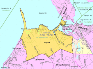
Noyack is a hamlet and census-designated place (CDP) in Suffolk County, New York, United States. The CDP population was 4,325 at the 2020 census.

Whitfield is a census-designated place (CDP) in Berks County, Pennsylvania, United States. The population was 4,733 at the 2010 census.

<span class="mw-page-title-main">Oakland, Lawrence County, Pennsylvania</span> Census-designated place in Pennsylvania, United States

Oakland is an unincorporated area and census-designated place (CDP) in Lawrence County, Pennsylvania, United States. The population was 1,569 at the 2010 census.

Lincoln is a census-designated place (CDP) consisting of the primary settlement in the town of Lincoln in Penobscot County, Maine, United States. The population was 2,884 at the 2010 census.

References

  1. "California's 9th Congressional District - Representatives & District Map". Civic Impulse, LLC. Retrieved March 12, 2013.
  2. U.S. Census Archived 2012-07-02 at the Wayback Machine
  3. "Explore Census Data". data.census.gov. Retrieved May 11, 2023.
  4. "US Gazetteer files: 2010, 2000, and 1990". United States Census Bureau. February 12, 2011. Retrieved April 23, 2011.
  5. Climate Summary for Lincoln Village, California
  6. "Census of Population and Housing". Census.gov. Retrieved June 4, 2016.
  7. "2010 Census Interactive Population Search: CA - Lincoln Village CDP". U.S. Census Bureau. Archived from the original on July 15, 2014. Retrieved July 12, 2014.
  8. "U.S. Census website". United States Census Bureau . Retrieved January 31, 2008.