Farmington, California

Last updated

Farmington
San Joaquin County California Incorporated and Unincorporated areas Farmington Highlighted.svg
Location in San Joaquin County and the state of California
Usa edcp location map.svg
Red pog.svg
Farmington
Location in the United States
Coordinates: 37°55′47″N120°59′58″W / 37.92972°N 120.99944°W / 37.92972; -120.99944
Country Flag of California.svg  California
County San Joaquin
Government
   Senate Tom Berryhill (R)
   Assembly Greg Aghazarian (R)
   U. S. Congress Josh Harder (D) [1]
Area
[2]
  Total2.542 sq mi (6.584 km2)
  Land2.542 sq mi (6.584 km2)
  Water0 sq mi (0 km2)  0%
Elevation
112 ft (34 m)
Population
 (2020)
  Total172
  Density68/sq mi (26/km2)
Time zone UTC-8 (Pacific (PST))
  Summer (DST) UTC-7 (PDT)
ZIP code
95230
Area code 209
FIPS code 06-23630
GNIS feature ID1656009

Farmington is a census-designated place (CDP) in San Joaquin County, California. The population was 172 at the 2020 census, down from 207 at the 2010 census.

Contents

History

Farmington was so named to distinguish its agricultural setting from the nearby mining regions. [3]

Geography

Farmington is located at 37°55′47″N120°59′58″W / 37.92972°N 120.99944°W / 37.92972; -120.99944 (37.929625, -120.999574). [4] According to the United States Census Bureau, the CDP has a total area of 2.5 square miles (6.5 km2), all of it land. Barren, low hills lie to the immediate east of the town, and farther east are the Sierra Nevada mountains. Stockton East Creek flows along the southern border of Farmington, paralleling Highway 4 for a short distance. [5] The creek and many other places nearby were used as locations in the 1958 film The Big Country , [6] as was scenes for the movie, Dirty Mary, Crazy Larry (1974). [7]

Demographics

Historical population
CensusPop.Note
U.S. Decennial Census [8]

2010

The 2010 United States Census [9] reported that Farmington had a population of 207. The population density was 81.4 inhabitants per square mile (31.4/km2). The racial makeup of Farmington was 164 (79.2%) White, 7 (3.4%) African American, 1 (0.5%) Native American, 6 (2.9%) Asian, 0 (0.0%) Pacific Islander, 18 (8.7%) from other races, and 11 (5.3%) from two or more races. Hispanic or Latino of any race were 42 persons (20.3%).

The Census reported that 207 people (100% of the population) lived in households, 0 (0%) lived in non-institutionalized group quarters, and 0 (0%) were institutionalized.

There were 79 households, out of which 26 (32.9%) had children under the age of 18 living in them, 46 (58.2%) were opposite-sex married couples living together, 5 (6.3%) had a female householder with no husband present, 6 (7.6%) had a male householder with no wife present. There were 6 (7.6%) unmarried opposite-sex partnerships, and 0 (0%) same-sex married couples or partnerships. 14 households (17.7%) were made up of individuals, and 7 (8.9%) had someone living alone who was 65 years of age or older. The average household size was 2.62. There were 57 families (72.2% of all households); the average family size was 2.98.

The population was spread out, with 45 people (21.7%) under the age of 18, 13 people (6.3%) aged 18 to 24, 49 people (23.7%) aged 25 to 44, 73 people (35.3%) aged 45 to 64, and 27 people (13.0%) who were 65 years of age or older. The median age was 43.9 years. For every 100 females, there were 102.9 males. For every 100 females age 18 and over, there were 102.5 males.

There were 98 housing units at an average density of 38.6 per square mile (14.9/km2), of which 54 (68.4%) were owner-occupied, and 25 (31.6%) were occupied by renters. The homeowner vacancy rate was 11.5%; the rental vacancy rate was 10.7%. 128 people (61.8% of the population) lived in owner-occupied housing units and 79 people (38.2%) lived in rental housing units.

2000

As of the census [10] of 2000, there were 262 people, 84 households, and 67 families residing in the CDP. The population density was 103.1 inhabitants per square mile (39.8/km2). There were 95 housing units at an average density of 37.4 per square mile (14.4/km2). The racial makeup of the CDP was 72.90% White, 1.53% Asian, 15.65% from other races, and 9.92% from two or more races. Hispanic or Latino of any race were 26.34% of the population.

There were 84 households, out of which 35.7% had children under the age of 18 living with them, 63.1% were married couples living together, 10.7% had a female householder with no husband present, and 20.2% were non-families. 16.7% of all households were made up of individuals, and 3.6% had someone living alone who was 65 years of age or older. The average household size was 3.12 and the average family size was 3.48.

In the CDP, the population was spread out, with 30.2% under the age of 18, 7.3% from 18 to 24, 21.8% from 25 to 44, 26.7% from 45 to 64, and 14.1% who were 65 years of age or older. The median age was 36 years. For every 100 females, there were 106.3 males. For every 100 females age 18 and over, there were 101.1 males.

The median income for a household in the CDP was $32,614, and the median income for a family was $32,727. Males had a median income of $20,250 versus $35,357 for females. The per capita income for the CDP was $13,289. About 15.5% of families and 15.3% of the population were below the poverty line, including 19.5% of those under the age of eighteen and none of those sixty-five or over.

Related Research Articles

<span class="mw-page-title-main">Dudleyville, Arizona</span> CDP in Pinal County, Arizona

Dudleyville is a census-designated place (CDP) in Pinal County, Arizona, United States. The population was 959 at the 2010 census.

<span class="mw-page-title-main">Mountain View, Contra Costa County, California</span> Census designated place in California, United States

Mountain View is a census designated place (CDP) in Contra Costa County, California, United States. The population was 2,372 at the 2010 census.

<span class="mw-page-title-main">Dustin Acres, California</span> Census-designated place in California, United States

Dustin Acres is a census-designated place (CDP) in Kern County, California, United States. Dustin Acres is located 6.5 miles (10 km) north-northeast of Taft, at an elevation of 384 feet (117 m). The population was 652 at the 2010 census, up from 585 at the 2000 census.

<span class="mw-page-title-main">Rosedale, California</span> Census-designated place in California, United States

Rosedale is a census-designated place (CDP) in Kern County, California, United States. The population was 14,058 at the 2010 census, up from 8,445 at the 2000 census. Formerly a country town 10 miles (16 km) west of Bakersfield, it is now surrounded by suburban housing and currently has the highest household income in Kern County, according to Census estimates.

<span class="mw-page-title-main">Lake Almanor Peninsula, California</span> Census-designated place in California, United States

Lake Almanor Peninsula is a census-designated place (CDP) in Plumas County, California, United States. The population was 356 at the 2010 census, up from 336 at the 2000 census.

<span class="mw-page-title-main">Lake Almanor West, California</span> Census-designated place in California, United States

Lake Almanor West is a census-designated place (CDP) in Plumas County, California, United States. The population was 270 at the 2010 census, down from 329 at the 2000 census.

<span class="mw-page-title-main">Taylorsville, California</span> Census-designated place in California, United States

Taylorsville is a census-designated place (CDP) in Plumas County, California, United States. The population was 150 at the 2010 census, down from 154 at the 2000 census. The annual Stone Ranch Reunion is held in Taylorsville.

<span class="mw-page-title-main">Tipton, California</span> Census-designated place in California, United States

Tipton is a census-designated place (CDP) in Tulare County, California, United States. The population was 2,543 at the 2010 census, up from 1,790 at the 2000 census.

<span class="mw-page-title-main">Honalo, Hawaii</span> Census-designated place in Hawaii, U.S.

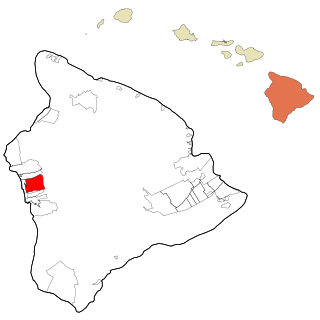
Honalo is a census-designated place (CDP) in Hawaiʻi County, Hawaiʻi, United States. The population was 2,423 at the 2010 census, up from 1,987 at the 2000 census.

<span class="mw-page-title-main">Simsbury Center, Connecticut</span> Census-designated place in Connecticut, United States

Simsbury Center is a census-designated place (CDP) that consists of the central settlement, and the neighborhoods immediately surrounding it, in the town of Simsbury, Connecticut, in the United States. As of the 2010 census, the CDP had a population of 5,836. The core area of the CDP is listed as the Simsbury Center Historic District on the National Register of Historic Places.

<span class="mw-page-title-main">Brownville, New Jersey</span> Populated place in Middlesex County, New Jersey, US

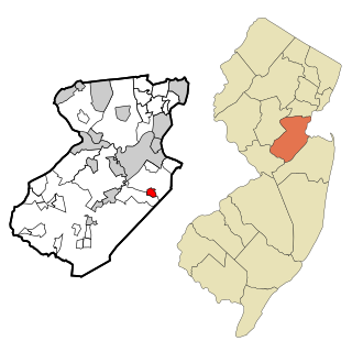
Brownville is an unincorporated community and census-designated place (CDP) located within Old Bridge Township, in Middlesex County, in the U.S. state of New Jersey. As of the 2010 United States Census, the CDP's population was 2,383.

<span class="mw-page-title-main">Beclabito, New Mexico</span> Census-designated place in San Juan County, New Mexico, United States

Beclabito is a census-designated place (CDP) in San Juan County, New Mexico, United States. The population was 317 at the 2010 census. It is part of the Farmington Metropolitan Statistical Area.

<span class="mw-page-title-main">Nageezi, New Mexico</span> CDP in New Mexico, United States

Nageezi is a census-designated place (CDP) in San Juan County, New Mexico, United States. The population was 296 at the 2000 census. It is part of the Farmington Metropolitan Statistical Area. A post office was established in 1941. Nageezi's name in Navajo means "squash."

<span class="mw-page-title-main">Naschitti, New Mexico</span> CDP in New Mexico, United States

Naschitti is a census-designated place (CDP) in San Juan County, New Mexico, United States. The population was 360 at the 2000 census. It is part of the Farmington Metropolitan Statistical Area. The town was established in 1886, when Tom Bryan set up a trading post east of the Chuska Mountains. With a Navajo name, Naschitti means "badger springs."

<span class="mw-page-title-main">Newcomb, New Mexico</span> CDP in New Mexico, United States

Newcomb is a census-designated place (CDP) in San Juan County, New Mexico, United States. The population was 387 at the 2000 census. It is part of the Farmington Metropolitan Statistical Area.

<span class="mw-page-title-main">Ojo Amarillo, New Mexico</span> CDP in New Mexico, United States

Ojo Amarillo is a census-designated place (CDP) in San Juan County, New Mexico, United States. The population was 829 at the 2000 census. It is part of the Farmington Metropolitan Statistical Area.

<span class="mw-page-title-main">Upper Fruitland, New Mexico</span> CDP in New Mexico, United States

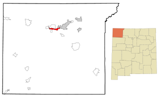
Upper Fruitland is a census-designated place (CDP) in San Juan County, New Mexico, United States. The population was 1,664 at the 2000 census. It is part of the Farmington Metropolitan Statistical Area.

<span class="mw-page-title-main">Covedale, Ohio</span> Census-designated place in Ohio, United States

Covedale is a census-designated place (CDP) in Green Township, Hamilton County, Ohio, United States. The population was 6,472 at the 2020 census. The CDP represents the part of the former village of Covedale that was not annexed by the city of Cincinnati in the 1890s.

<span class="mw-page-title-main">Fredericktown-Millsboro, Pennsylvania</span> Former CDP in Pennsylvania, United States

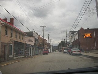
Fredericktown-Millsboro was a census-designated place (CDP) in East Bethlehem Township, Washington County, Pennsylvania, United States. The population was 1,094 at the 2000 census. For the 2010 census the area was split into two CDPs, Fredericktown and Millsboro.

<span class="mw-page-title-main">Farmington (CDP), Maine</span> Census-designated place in Maine, United States

Farmington is a census-designated place (CDP) comprising the center of the town of Farmington, which is the county seat of Franklin County in Maine, United States. The population of the CDP was 4,288 at the 2010 census, out of 7,760 people in the town as a whole. The University of Maine at Farmington is located within the CDP.

References

  1. "California's 9th Congressional District - Representatives & District Map". Civic Impulse, LLC. Retrieved March 12, 2013.
  2. "U.S. Census". Archived from the original on January 12, 2012.
  3. Gannett, Henry (1905). The Origin of Certain Place Names in the United States. Govt. Print. Off. pp.  124.
  4. "US Gazetteer files: 2010, 2000, and 1990". United States Census Bureau. February 12, 2011. Retrieved April 23, 2011.
  5. "Google Maps". Google Maps.
  6. "Orvis Cattle Company - Big Country". www.orvisranch.com.
  7. Dirty Mary, Crazy Larry at IMDb   OOjs UI icon edit-ltr-progressive.svg
  8. "Census of Population and Housing". Census.gov. Retrieved June 4, 2016.
  9. "2010 Census Interactive Population Search: CA - Farmington CDP". U.S. Census Bureau. Archived from the original on December 28, 2016. Retrieved July 12, 2014.
  10. "U.S. Census website". United States Census Bureau . Retrieved January 31, 2008.