Borough of Princeton, New Jersey | |
---|---|
Coordinates: 40°21′02″N74°39′34″W / 40.350461°N 74.659371°W | |
Country | United States |
State | New Jersey |
County | Mercer |
Incorporated | February 11, 1813 |
Disestablished | January 1, 2013 |
Government | |
• Type | Borough |
• Body | Borough Council |
• Mayor | Yina Moore (D, term ended December 31, 2012) [2] [3] [4] |
• Administrator | Robert W. Bruschi [5] |
• Clerk | Robert W. Bruschi (acting) [6] |
Area | |
• Total | 1.843 sq mi (4.774 km2) |
• Land | 1.843 sq mi (4.772 km2) |
• Water | 0.000 sq mi (0.001 km2) 0.03% |
• Rank | 423rd of 566 in state 10th of 13 in county [7] |
Elevation | 190 ft (58 m) |
Population | |
• Total | 12,307 |
• Rank | 198th of 566 in state 10th of 13 in county [12] |
• Density | 6,679.2/sq mi (2,578.9/km2) |
• Rank | 70th of 566 in state 2nd of 13 in county [12] |
Time zone | UTC-5 (Eastern (EST)) |
• Summer (DST) | UTC-4 (Eastern (EDT)) |
ZIP code | 08540, 08542 [13] |
Area code(s) | 609 and 640 |
FIPS code | 3402160900 [7] [14] [15] |
GNIS feature ID | 0885361 [7] [16] |
Website | http://www.princetonboro.org/ |
The Borough of Princeton was a borough that existed independently until December 31, 2012, that is now one of the two former municipalities making up Princeton, New Jersey. It was located in Mercer County, in the U.S. state of New Jersey, and was completely surrounded by the former Princeton Township, from which it was formed in 1894. As of the 2010 United States census, the borough had a population of 12,307, [9] [10] [11] reflecting a decline of 1,896 (-13.3%) from the 14,203 counted in the 2000 Census, which had in turn increased by 2,187 (+18.2%) from the 12,016 counted in the 1990 Census. [17]
The Borough of Princeton was incorporated by an act of the New Jersey Legislature on February 11, 1813, within portions of West Windsor Township (in what was then part of Middlesex County) and Montgomery Township (in Somerset County), and was reincorporated on November 27, 1822. The borough became part of the newly created Mercer County in 1838, and became a fully independent municipality circa 1894. Portions of territory were acquired from Princeton Township on January 4, 1928, and August 21, 1951. [18] On November 8, 2011, voters in Princeton Borough voted to consolidate with Princeton Township. [19]
Morven, the former residence of the Governor of New Jersey, is at 55 Stockton Street in the former borough, while the current residence is Drumthwacket in the former township.
Princeton borough was located at 40°21′02″N74°39′34″W / 40.350461°N 74.659371°W (40.350461,-74.659371). According to the U.S. Census Bureau, the borough had a total area of 1.843 square miles (4.774 km2), all of which was land. [7] [20]
Census | Pop. | Note | %± |
---|---|---|---|
1870 | 2,798 | — | |
1880 | 3,209 | 14.7% | |
1890 | 3,422 | 6.6% | |
1900 | 3,899 | 13.9% | |
1910 | 5,136 | 31.7% | |
1920 | 5,917 | 15.2% | |
1930 | 6,992 | 18.2% | |
1940 | 7,719 | 10.4% | |
1950 | 12,230 | 58.4% | |
1960 | 11,890 | −2.8% | |
1970 | 12,311 | 3.5% | |
1980 | 12,035 | −2.2% | |
1990 | 12,016 | −0.2% | |
2000 | 14,203 | 18.2% | |
2010 | 12,307 | −13.3% | |
2011 (est.) | 12,131 | [21] | −1.4% |
Population sources: 1870 [22] 1880-1890 [23] 1890-1910 [24] 1910-1930 [25] 1930-1990 [26] 2000 [27] 2010 [9] [10] [11] |
The 2010 United States census counted 12,307 people, 3,161 households, and 1,644 families in the borough. The population density was 6,679.2 per square mile (2,578.9/km2). There were 3,488 housing units at an average density of 1,893.0 per square mile (730.9/km2). The racial makeup was 72.07% (8,870) White, 6.44% (793) Black or African American, 0.18% (22) Native American, 13.51% (1,663) Asian, 0.16% (20) Pacific Islander, 4.13% (508) from other races, and 3.50% (431) from two or more races. Hispanic or Latino of any race were 10.30% (1,268) of the population. [9]
Of the 3,161 households, 24.2% had children under the age of 18; 42.4% were married couples living together; 6.6% had a female householder with no husband present and 48.0% were non-families. Of all households, 39.6% were made up of individuals and 14.9% had someone living alone who was 65 years of age or older. The average household size was 2.21 and the average family size was 2.96. [9]
11.7% of the population were under the age of 18, 43.7% from 18 to 24, 19.6% from 25 to 44, 14.7% from 45 to 64, and 10.2% who were 65 years of age or older. The median age was 22.9 years. For every 100 females, the population had 104.5 males. For every 100 females ages 18 and older there were 103.6 males. [9]
The Census Bureau's 2006-2010 American Community Survey showed that (in 2010 inflation-adjusted dollars) median household income was $104,234 (with a margin of error of +/- $20,004) and the median family income was $148,295 (+/- $34,644). Males had a median income of $96,225 (+/- $29,348) versus $82,572 (+/- $28,930) for females. The per capita income for the borough was $45,566 (+/- $5,208). About 2.5% of families and 6.5% of the population were below the poverty line, including 0.0% of those under age 18 and 8.5% of those age 65 or over. [28]
As of the 2000 United States Census [14] there were 14,203 people, 3,326 households, and 1,692 families residing in the borough. The population density was 7,686.3 inhabitants per square mile (2,967.7/km2). There were 3,495 housing units at an average density of 1,891.4 per square mile (730.3/km2). The racial makeup of the borough was 80.26% White, 6.39% African American, 0.28% Native American, 7.46% Asian, 0.14% Pacific Islander, 2.50% from other races, and 2.96% from two or more races. Hispanic or Latino of any race were 7.10% of the population. [27] [29] Most of the Hispanic population consists of Mexican and Guatemalan immigrants.
There were 3,326 households, out of which 22.3% had children under the age of 18 living with them, 42.5% were married couples living together, 6.4% had a female householder with no husband present, and 49.1% were non-families. 40.1% of all households were made up of individuals, and 12.0% had someone living alone who was 65 years of age or older. The average household size was 2.20 and the average family size was 2.92. [27] [29]
In the borough the population was spread out, with 10.1% under the age of 18, 40.9% from 18 to 24, 27.4% from 25 to 44, 12.3% from 45 to 64, and 9.3% who were 65 years of age or older. The median age was 25 years. For every 100 females, there were 108.2 males. For every 100 females age 18 and over, there were 107.8 males. [27] [29] The borough's unusually low median age and high concentration of 18- to 24-year-olds is influenced by Princeton University.
The median income for a household in the borough was $67,346, and the median income for a family was $102,957. Males had a median income of $60,341 versus $52,900 for females. The per capita income for the borough was $27,292. About 2.9% of families and 9.0% of the population were below the poverty line, including 5.4% of those under age 18 and 6.8% of those age 65 or over. [27] [29]
According to the Köppen climate classification system, the Borough of Princeton has a Hot-summer Humid continental climate (Dfa).
Climate data for Princeton Twp (40.3512, -74.6575), Elevation 184 ft (56 m), 1991–2020 normals, extremes 1981–2022 | |||||||||||||
---|---|---|---|---|---|---|---|---|---|---|---|---|---|
Month | Jan | Feb | Mar | Apr | May | Jun | Jul | Aug | Sep | Oct | Nov | Dec | Year |
Record high °F (°C) | 71.2 (21.8) | 77.7 (25.4) | 87.6 (30.9) | 94.8 (34.9) | 95.4 (35.2) | 97.2 (36.2) | 102.6 (39.2) | 100.4 (38.0) | 97.4 (36.3) | 93.4 (34.1) | 80.4 (26.9) | 75.2 (24.0) | 102.6 (39.2) |
Average high °F (°C) | 39.8 (4.3) | 42.3 (5.7) | 50.1 (10.1) | 62.4 (16.9) | 72.0 (22.2) | 81.2 (27.3) | 85.8 (29.9) | 84.0 (28.9) | 77.6 (25.3) | 65.6 (18.7) | 54.9 (12.7) | 44.8 (7.1) | 63.5 (17.5) |
Average low °F (°C) | 22.7 (−5.2) | 24.1 (−4.4) | 31.0 (−0.6) | 40.9 (4.9) | 50.8 (10.4) | 59.9 (15.5) | 65.1 (18.4) | 63.3 (17.4) | 56.2 (13.4) | 44.5 (6.9) | 34.8 (1.6) | 27.8 (−2.3) | 43.5 (6.4) |
Record low °F (°C) | −12.0 (−24.4) | −3.5 (−19.7) | 3.4 (−15.9) | 17.5 (−8.1) | 31.3 (−0.4) | 40.3 (4.6) | 46.3 (7.9) | 41.0 (5.0) | 34.7 (1.5) | 23.8 (−4.6) | 9.4 (−12.6) | −0.3 (−17.9) | −12.0 (−24.4) |
Average precipitation inches (mm) | 3.58 (91) | 2.82 (72) | 4.26 (108) | 3.77 (96) | 4.09 (104) | 4.57 (116) | 5.00 (127) | 4.47 (114) | 4.23 (107) | 4.16 (106) | 3.36 (85) | 4.41 (112) | 48.72 (1,237) |
Average snowfall inches (cm) | 8.2 (21) | 8.7 (22) | 4.2 (11) | 0.2 (0.51) | 0.0 (0.0) | 0.0 (0.0) | 0.0 (0.0) | 0.0 (0.0) | 0.0 (0.0) | 0.2 (0.51) | 0.7 (1.8) | 3.7 (9.4) | 26.0 (66) |
Average dew point °F (°C) | 21.2 (−6.0) | 21.7 (−5.7) | 27.2 (−2.7) | 36.8 (2.7) | 48.9 (9.4) | 59.2 (15.1) | 64.0 (17.8) | 63.4 (17.4) | 57.4 (14.1) | 45.8 (7.7) | 34.4 (1.3) | 26.9 (−2.8) | 42.3 (5.7) |
Source 1: PRISM [30] | |||||||||||||
Source 2: NOHRSC (Snow, 2008/2009 - 2022/2023 normals) [31] |
According to the A. W. Kuchler U.S. potential natural vegetation types, the Borough of Princeton would have a dominant vegetation type of Appalachian Oak (104) with a dominant vegetation form of Eastern Hardwood Forest (25). [32]
The Borough of Princeton was governed under the borough form of New Jersey municipal government. The government consisted of a mayor and a borough council comprising six council members, with all positions elected at large. A mayor was elected directly by the voters to a four-year term of office. The borough council consisted of six members elected to serve three-year terms on a staggered basis, with two seats coming up for election each year. [1]
The mayor served as the borough's chief executive officer and nominated appointees to various boards and commissions subject to approval of the borough council. The mayor presided at the borough council meetings and voted in the case of a tie or a few other specific cases.
The borough council had administrative powers and was the policy-making body of the borough. The council had six members; two were elected each year and they served three-year terms. The council approved appointments made by the mayor. Council Members served on various boards and committees and acted as liaison's to certain Departments, Committees or Boards. The mayor of the Borough of Princeton, New Jersey, was Yina Moore (D, term ended on December 31, 2012). Members of the borough council were Jo Butler (D, 2012), Jenny Crumiller (D, 2012), Heather Howard (D, 2012), Roger Martindell (D, 2012), Barbara Trelstad (D, 2012) and Kevin Wilkes (D, 2012). [2] [3]
On November 8, 2011, the residents of both the Borough of Princeton and the Township of Princeton voted to merge the two municipalities into one. In Princeton Borough 1,385 voted for, 902 voted against while in Princeton Township 3,542 voted for and 604 voted against. Proponents of the merger asserted that when the merger is completed the new municipality of Princeton will save $3.2 million as a result of some scaled-down services, including layoffs of 15 government workers, including 9 police officers (however, the measure itself does not mandate such layoffs). Opponents of the measure challenged the findings of the report, citing cost savings as unsubstantiated, and noted that voter representation would be reduced in a smaller government structure. [19] The consolidation took effect on January 1, 2013. [33] December 31, 2012 was the last day the Borough of Princeton existed as a municipality.
The Borough of Princeton was in the 12th Congressional district [34] and was part of New Jersey's 16th state legislative district. [10] [35] Prior to the 2011 reapportionment following the 2010 Census, Princeton Boro had been in the 15th state legislative district. [34]
For the 118th United States Congress , New Jersey's Twelfth Congressional District is represented by Bonnie Watson Coleman ( D , Ewing Township ). [36] [37] New Jersey is represented in the United States Senate by Democrats Cory Booker ( Newark , term ends 2027) [38] and Bob Menendez ( Englewood Cliffs , term ends 2025). [39] [40]
For the 2022–2023 session , the 16th Legislative District of the New Jersey Legislature is represented in the New Jersey Senate by Andrew Zwicker ( D , South Brunswick ) and in the General Assembly by Roy Freiman (D, Hillsborough Township ) and Sadaf Jaffer (D, Montgomery Township ). [41]
Mercer County is governed by a County Executive who oversees the day-to-day operations of the county and by a seven-member Board of County Commissioners that acts in a legislative capacity, setting policy. All officials are chosen at-large in partisan elections, with the executive serving a four-year term of office while the freeholders serve three-year terms of office on a staggered basis, with either two or three seats up for election each year as part of the November general election. [42] As of 2023 [update] , the County Executive is Brian M. Hughes ( D , Princeton , term of office ends December 31, 2023). [43] Mercer County's Commissioners are Commissioner Chair Lucylle R. S. Walter (D, Ewing Township , term as commissioner and as chair ends December 31, 2023), [44] Vice Chair John A. Cimino (D, Hamilton Township, term as commissioner and as vice chair ends 2023), [45] Samuel T. Frisby Sr. (D, Trenton , 2024), [46] Cathleen M. Lewis (D, Lawrence Township , 2025), [47] Kristin L. McLaughlin (D, Hopewell Township , 2024), [48] Nina D. Melker (D, Hamilton Township , 2025) [49] and Terrance Stokes (D, Ewing Township, 2024). [50] [51] [52] Mercer County's constitutional officers are County Clerk Paula Sollami-Covello (D, Lawrence Township, 2025), [53] [54] Sheriff John A. Kemler (D, 2023) [55] [56] and Surrogate Diane Gerofsky (D, 2026). [57] [58] [59]
As of March 23, 2011, there were a total of 6,561 registered voters in the Borough of Princeton, of which 3,493 (53.2%) were registered as Democrats, 620 (9.4%) were registered as Republicans and 2,440 (37.2%) were registered as Unaffiliated. There were 8 voters registered to other parties. [60]
In the 2008 presidential election, Democrat Barack Obama received 80.4% of the vote here (3,880 cast), ahead of Republican John McCain with 17.0% (819 votes) and other candidates with 1.1% (51 votes), among the 4,828 ballots cast by the borough's 7,679 registered voters, for a turnout of 62.9%. [61] In the 2004 presidential election, Democrat John Kerry received 73.0% of the vote here (3,475 ballots cast), outpolling Republican George W. Bush with 21.9% (1,043 votes) and other candidates with 1.0% (67 votes), among the 4,763 ballots cast by the borough's 6,938 registered voters, for a turnout percentage of 68.7. [62]
In the 2009 gubernatorial election, Democrat Jon Corzine received 69.4% of the vote here (1,786 ballots cast), ahead of Republican Chris Christie with 23.6% (608 votes), Independent Chris Daggett with 5.4% (139 votes) and other candidates with 0.7% (18 votes), among the 2,572 ballots cast by the borough's 7,026 registered voters, yielding a 36.6% turnout. [63]
Two thirds of the buildings of Princeton University were located within the borough (the rest of Princeton University, aside from a small enclave and the Plasma Physics Laboratory in West Windsor Township and land in East Windsor Township, were in the township). However, the university owns more land in West Windsor than in the two Princeton municipalities combined.
Westminster Choir College (part of Rider University) and most of Princeton Theological Seminary were located in the borough.
The Institute for Advanced Study was in the township.
For grades K through 12, public school students attended the Princeton Regional Schools, a regional school district shared with Princeton Township that also serves students from Cranbury Township, as part of a sending/receiving relationship. [64] All of the district's schools through eighth grade were in the former Princeton Township, with Community Park School being the closest primary school to the defunct borough. The district's high school was located within the borough of Princeton.
The Princeton Charter School, located in the township, opened in September 1997 and serves students from the borough and township who are selected by lottery from among applicants. [65] [66]
Private schools located in the borough include St. Paul School.
The Princeton Public Library, located in the borough, serves the borough and the township.
Princeton is the setting for the fictional Princeton-Plainsboro Teaching Hospital in the TV series House .
Mercer County is a county located in the U.S. state of New Jersey. Its county seat is Trenton, also the state capital, prompting its nickname The Capital County. Mercer County alone constitutes the Trenton–Princeton metropolitan statistical area and is considered part of the New York combined statistical area by the U.S. Census Bureau, but also directly borders the Philadelphia metropolitan area and is included within the Federal Communications Commission's Philadelphia Designated Media Market Area.
Pemberton is a borough in Burlington County, in the U.S. state of New Jersey. As of the 2020 United States census, the borough's population was 1,371, a decrease of 38 (−2.7%) from the 2010 census count of 1,409, which in turn reflected an increase of 199 (+16.4%) from the 1,210 counted in the 2000 census. The township, and all of Burlington County, is a part of the Philadelphia-Reading-Camden combined statistical area and the Delaware Valley.
Pine Hill is a borough in Camden County, in the U.S. state of New Jersey. As of the 2020 United States census, the borough's population was 10,743, an increase of 510 (+5.0%) from the 2010 census count of 10,233, which in turn reflected a decline of 647 (−5.9%) from the 10,880 counted in the 2000 census.
Pine Valley was a borough in Camden County, in the U.S. state of New Jersey. As of the 2020 United States census, the borough's population was 21, an increase of 9 (+75.0%) from the 2010 census count of 12, which in turn reflected a decline of 8 (-40.0%) from the 20 counted in the 2000 census. As of the 2020 Census, Pine Valley was the third-smallest municipality by population in New Jersey, with 12 more residents than the nine residing in Tavistock and 14 more than the seven in Walpack Township.
National Park is a borough in Gloucester County, in the U.S. state of New Jersey. As of the 2020 United States census, the borough's population was 3,026, a decrease of 10 (−0.3%) from the 2010 census count of 3,036, which in turn reflected a decline of 169 (−5.3%) from the 3,205 counted in the 2000 census. Despite its name, National Park is neither a national park nor associated with one.
Lebanon is a borough in Hunterdon County,in the U.S. state of New Jersey. As of the 2020 United States census, the borough's population was 1,665, the highest ever in any decennial census and an increase of 307 (+22.6%) from the 2010 census count of 1,358, which in turn reflected an increase of 293 (+27.5%) from the 1,065 counted in the 2000 census.
East Windsor is a township in Mercer County, in the U.S. state of New Jersey. Located within the Raritan Valley region, the township is an outer-ring suburb of New York City in the New York Metropolitan area, as defined by the United States Census Bureau, but directly borders the Philadelphia metropolitan area and is part of the Federal Communications Commission's Philadelphia Designated Market Area. Since East Windsor is situated at the confluence of several major highways that serve both the major cities of New York City and Philadelphia, and even the local commercial hubs of nearby Freehold, Princeton, and the state capital of Trenton, the community has been a longtime residential, commercial, and industrial hub in the heart of Central New Jersey.
Ewing Township is a township in Mercer County, in the U.S. state of New Jersey. The township falls within the New York metropolitan area as defined by the U.S. Census Bureau. It borders the Philadelphia metropolitan area and is part of the Federal Communications Commission's Philadelphia Designated Market Area. As of the 2020 United States census, the township's population was 37,264, its highest decennial count ever and an increase of 1,474 (+4.1%) from the 35,790 recorded at the 2010 census, which in turn reflected an increase of 83 (+0.2%) from the 35,707 counted in the 2000 census.
Hightstown is a borough in Mercer County, in the U.S. state of New Jersey. As of the 2020 United States census, the borough's population was 5,900, its highest decennial count ever and an increase of 406 (+7.4%) from the 5,494 recorded at the 2010 census, which in turn reflected an increase of 278 (+5.3%) from the 5,216 counted in the 2000 census.
Hopewell is a borough in Mercer County, in the U.S. state of New Jersey. This historical settlement is located within the heart of the Raritan Valley region. As of the 2020 United States census, the borough's population was 1,918, a decrease of 4 (−0.2%) from the 2010 census count of 1,922, which in turn had reflected a decline of 113 (−5.6%) from the 2,035 counted in the 2000 census.
Hopewell Township is a township in Mercer County, in the U.S. state of New Jersey. Located within the Raritan Valley region, the township is an exurb of New York City in the New York metropolitan area as defined by the United States Census Bureau, while also directly bordering the Philadelphia metropolitan area, being a part of the Federal Communications Commission's Philadelphia Designated Market Area. As of the 2020 United States census, the township's population was 17,491, its highest decennial count ever and an increase of 187 (+1.1%) from the 2010 census count of 17,304, which in turn reflected an increase of 1,199 (+7.4%) from the 16,105 counted in the 2000 census.
Lawrence Township is a township in Mercer County, in the U.S. state of New Jersey. Located at the cross-roads between the Delaware Valley region to the south and the Raritan Valley region to the north, the township is an outer-ring suburb of New York City in the New York Metropolitan area, as defined by the United States Census Bureau, while also directly bordering the Philadelphia metropolitan area and is part of the Federal Communications Commission's Philadelphia Designated Market Area. The township is a regional commercial hub for central New Jersey. As of the 2020 United States census, the township's population was 33,077, a decrease of 395 (−1.2%) from the 2010 census count of 33,472, which in turn reflected an increase of 4,313 (+14.8%) from the 29,159 counted in the 2000 census.
Pennington is a borough in Mercer County, in the U.S. state of New Jersey. The borough is located at the cross-roads between the Delaware Valley region to the south and the Raritan Valley region to the north. As of the 2020 United States census, the borough's population was 2,802, its highest decennial count ever and an increase of 217 (+8.4%) from the 2010 census count of 2,585, which in turn had reflected a decline of 111 (−4.1%) from the 2,696 counted in the 2000 census.
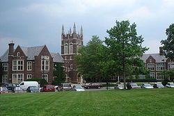
Princeton Township was a township in Mercer County, New Jersey, United States, that existed from 1838 until it was dissolved after it was merged with Princeton Borough in 2013 to form Princeton, New Jersey. As of the 2010 United States Census, the township's population was 16,265, reflecting an increase of 238 (+1.5%) from the 16,027 counted in the 2000 Census, which had in turn increased by 2,829 (+21.4%) from the 13,198 counted in the 1990 Census.
Robbinsville Township is a township in Mercer County, in the U.S. state of New Jersey. The township is part of the New York Metropolitan area as defined by the United States Census Bureau, but directly borders the Philadelphia metropolitan area and is part of the Federal Communications Commission's Philadelphia Designated Market Area. As of the 2020 United States census, the township's population was 15,476, its highest decennial count ever and an increase of 1,834 (+13.4%) from the 13,642 recorded at the 2010 census, which in turn reflected an increase of 3,367 (+32.8%) from the 10,275 counted in the 2000 census. The township is named for George R. Robbins, who served in the United States House of Representatives from 1855 to 1859 and lived in the area. Inspired by its central geographical location within New Jersey, Robbinsville's motto is Be at the Center of it All.
West Windsor is a township in Mercer County, in the U.S. state of New Jersey. Located within the Raritan Valley region, the township is an outer-ring suburb of New York City in the New York metropolitan area, as defined by the United States Census Bureau. As of the 2020 United States census, the township's population was 29,518, its highest decennial count ever and an increase of 2,353 (+8.7%) from the 27,165 recorded at the 2010 census, which in turn reflected an increase of 5,258 (+24.0%) from the 21,907 counted in the 2000 census.
Jamesburg is a borough in Middlesex County, in the U.S. state of New Jersey. As of the 2020 United States census, the borough's population was 5,783, a decrease of 132 (−2.2%) from the 2010 census count of 5,915, which in turn reflected a decline of 110 (−1.8%) from the 6,025 counted in the 2000 census.
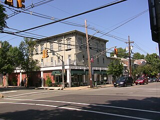
Allentown is a borough, located in western Monmouth County, in the U.S. state of New Jersey, bordering nearby Mercer County. As of the 2020 United States census, the borough's population was 1,734, a decrease of 94 (−5.1%) from the 2010 census count of 1,828, which in turn reflected a decline of 54 (−2.9%) from the 1,882 counted in the 2000 census. The borough is nestled within central New Jersey, and is roughly equidistant between New York City and Philadelphia.
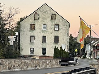
Rocky Hill is a borough in Somerset County, in the U.S. state of New Jersey. Named for the Rocky Hill Ridge, this historic village is nestled within the heart of the Raritan Valley region, located alongside the course of the Millstone River.
Washington Township is a township in Warren County, in the U.S. state of New Jersey. As of the 2020 United States census, the township's population was 6,492, a decrease of 159 (−2.4%) from the 2010 census count of 6,651, which in turn reflected an increase of 403 (+6.5%) from the 6,248 counted in the 2000 census.