Maiden Castle is an Iron Age hillfort 1.6 mi (2.6 km) southwest of Dorchester, in the English county of Dorset. Hill forts were fortified hill-top settlements constructed across Britain during the Iron Age.

Uffington Castle is an early Iron Age univallate hillfort in Oxfordshire, England. It covers about 32,000 square metres and is surrounded by two earth banks separated by a ditch with an entrance in the western end. A second entrance in the eastern end was apparently blocked up a few centuries after it was built. The original defensive ditch was V-shaped with a small box rampart in front and a larger one behind it. Timber posts stood on the ramparts. Later the ditch was deepened and the extra material dumped on top of the ramparts to increase their size. A parapet wall of sarsen stones lined the top of the innermost rampart. It is very close to the Uffington White Horse on White Horse Hill.
Liddington Castle, locally called Liddington Camp, is a late Bronze Age and early Iron Age univallate hillfort in Liddington parish in the English county of Wiltshire, and a scheduled monument.

Tisbury is a large village and civil parish approximately 13 miles (21 km) west of Salisbury in the English county of Wiltshire. With a population at the 2011 census of 2,253 it is a centre for communities around the upper River Nadder and Vale of Wardour. The parish includes the hamlets of Upper Chicksgrove and Wardour.

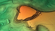
Yarnbury Castle is the site of a multiphase, multivallate Iron Age hillfort near the village of Steeple Langford, Wiltshire, England. The site covers an area of 28.5 acres (11.5 ha), and was extensively surveyed and investigated by the Royal Commission on the Historical Monuments of England in 1991, with finds of Iron Age and Romano-British pottery, Iron Age and Roman coins, and burials of human remains. There is much evidence of prolonged and extensive settlement of the site, including evidence of around 130 structures of various sizes, most probably representing a mix of round houses, pits, and other features. It was designated as a scheduled monument in 1925.

Swallowcliffe is a small village and civil parish in Wiltshire, England, about 2 miles (3.2 km) southeast of Tisbury and 11 miles (18 km) west of Salisbury. The village lies about half a mile north of the A30 Shaftesbury-Wilton road which crosses the parish.

Castercliff is an Iron Age multivallate hillfort situated close to the towns of Nelson and Colne in Lancashire, Northern England.

Kenwalch's Castle is probably an Iron Age hill fort that may have been converted into a Roman fortress, near Penselwood, Somerset, England, 6.6 kilometres (4 mi) east south east of Bruton at grid reference ST747335. It is a Scheduled Ancient Monument. It is believed to be named after Cenwalh of Wessex.

Maiden Castle is an Iron Age hill fort, one of many fortified hill-top settlements constructed across Britain during the Iron Age, but one of only seven in the county of Cheshire in northern England. The hill fort was probably occupied from its construction in 600 BC until the Roman conquest of Britain in the 1st century AD. At this time the Cornovii tribe are recorded to have occupied parts of the surrounding area but, because they left no distinctive pottery or metalworking, their occupation has not been verified. Since then it has been quarried and used for military exercises. It is protected as a Scheduled Ancient Monument, and is owned by the National Trust. The hill fort is open to visitors, but unrestricted access to the site has resulted in it being classified as "at high risk" from erosion.
Eddisbury hill fort, also known as Castle Ditch, is an Iron Age hill fort near Delamere, Cheshire, in northern England. Hill forts are fortified hill-top settlements constructed across Britain during the Iron Age. Eddisbury is the largest and most complex of the seven hill forts in the county of Cheshire. It was constructed before 200–100 BC and expanded in 1–50 AD. In the 1st century AD, the Romans slighted the site. It was reoccupied in the 6th–8th centuries AD, and an Anglo-Saxon burh was probably established at Eddisbury in 914. In the medieval and post-medieval periods quarrying and farming have damaged the site. Ownership is currently split between the Forestry Commission and a local farm. Eddisbury is protected as a Scheduled Ancient Monument.

Battlesbury Camp is the site of an Iron Age bivallate hill fort on Battlesbury Hill near the town of Warminster in Wiltshire, South West England. Excavations and surveys at the site have uncovered various finds and archaeological evidence.

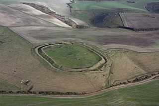
Scratchbury Camp is the site of an Iron Age univallate hillfort on Scratchbury Hill, overlooking the Wylye valley about 1 km northeast of the village of Norton Bavant in Wiltshire, England. The fort covers an area of 37 acres (15 ha) and occupies the summit of the hill on the edge of Salisbury Plain, with its four-sided shape largely following the natural contours of the hill.

Bury Camp is the site of an Iron Age multivallate hillfort in north-west Wiltshire, England. It occupies a triangular promontory of Colerne Down, in the north of Colerne parish, at the southern edge of the Cotswold Hills between two spurs of a river valley. The enclosed area of approximately 9.2ha is surrounded by a ditch 4m wide and up to 1m deep, and an outer rampart up to 1.5m high on the east and northwestern sides and up to 2m high on the southwestern side, across the neck of the promontory.

Chiselbury is the site of an Iron Age univallate hillfort in Wiltshire, England. The hillfort is sub-circular in plan, and encloses an area of approximately 10.5 acres (460,000 sq ft). It is defined by an earthen rampart up to 3.6 metres (12 ft) in height and an external ditch, up to a maximum of 1.6 metres (5.2 ft) in depth. A gap in the south-eastern side of the rampart, and a corresponding causeway across the ditch, is thought to be the original entrance and is associated with a small 'D' shaped embanked enclosure, which is apparently visible on aerial photographs. Although the enclosure has subsequently been degraded by ploughing, it is still apparent as a series of low earthworks.

Sidbury Hill, or Sidbury Camp, is the site of an Iron Age bivallate hillfort on the eastern edge of Salisbury Plain in Wiltshire, England. The site is sub-triangular in shape, approximately 17 acres (6.9 ha) in area, and is constructed on the site of a Neolithic settlement.

Bratton Castle is a bivallate Iron Age built hill fort on Bratton Down, at the western edge of the Salisbury Plain escarpment. The hill fort comprises two circuits of ditch and bank which together enclose a pentagonal area of 9.3 hectares.
Grovely Castle is the site of an Iron Age univallate hill fort in the parish of Steeple Langford, in Wiltshire, England. The remaining ramparts stand approximately 3.2 m (10 ft) high, with 1.5 m (4.9 ft) deep ditches, although ploughing has damaged the earthworks in some parts of the site. Excavations have uncovered the remains of five human skeletons within the ramparts. Entrances are in the south-west and north-east corners of the hillfort. A circular enclosure of 35 to 40 m is evident in aerial photographs of the hillfort interior. There is also a later bank and ditch which runs through the hill-fort from south-west to north-east, and is probably part of an extensive surrounding Celtic field system.

Sutton Mandeville is a small village and civil parish in Wiltshire, England, in the Nadder valley and towards the east end of the Vale of Wardour. The village lies south of the river and north of the A30 Shaftesbury-Wilton road, about 7 miles (11 km) west of Wilton and 2.5 miles (4 km) east of the large village of Tisbury.

Hollingbury Castle, also known as Hollingbury Camp and Hollingbury Hillfort, is an Iron Age hillfort on the northern edge of Brighton, in East Sussex, England. It is adjacent to Hollingbury Park Golf Course.
Dungeon Hill is an Iron Age hillfort, about 1+1⁄4 miles north of the village of Buckland Newton in Dorset, England. It is a scheduled monument.