Coxall Knoll

Last updated

Coxall Knoll
Ramparts, Coxall Knoll (geograph 3151337).jpg
Ramparts of Coxall Knoll
Shropshire UK location map.svg
Archaeological site icon (red).svg
Shown within Shropshire
Locationnear Bucknell, Shropshire
Coordinates 52°21′19″N2°56′00″W / 52.3553°N 2.9334°W / 52.3553; -2.9334
OS grid reference SO 366 734
Altitude262 m (860 ft)
Type Hillfort
History
Periods Iron Age
Designated3 September 1935
Reference no.1014107

Coxall Knoll is a hill lying on the boundary of Shropshire and Herefordshire, England; it is near Bucknell in Shropshire and Buckton and Coxall in Herefordshire. On the summit is an Iron Age hillfort, a scheduled monument. [1] [2]

Description

The height of the hill is 262 metres (860 ft) and it has a prominence of 120 metres (390 ft). [3]

The hillfort Brandon Camp lies about 3 kilometres (1.9 mi) to the east-south-east, across the River Teme, and there are buried remains of Roman camps in between, including Buckton Roman Fort; so it is supposed that there was activity in the area into the Roman period. [1]

The hillfort on the summit is roughly oval in shape, measuring about 570 metres (1,870 ft) west to east and 200 metres (660 ft) north to south. There are earthen banks following the contours of the hill; the slopes below have been made steeper by the builders of the fort. The main enclosure, with three banks and ditches to the north, has an area of about 3 hectares (7.4 acres). Adjoining is a roughly triangular eastern enclosure with an area of about 1.8 hectares (4.4 acres), and an enclosure to the north of this with an area of about 0.7 hectares (1.7 acres). These two seem to be additions to the main enclosure. [1] [4]

The main entrance to the fort, on the west side, is defined by inturned banks. The south entrance is at the junction of the east and west enclosures. In the north there are two breaks in the banks. [1] [4]

In the northern enclosure there is a recumbent stone, perhaps dating from the Bronze Age. It is known, because of its shape, as the Frog Stone. There is no trace of a hollow where it might have once stood upright; it may have been placed here by the builders of the fort, or by earlier inhabitants. [1] [5]

Related Research Articles

<span class="mw-page-title-main">Oldbury Camp</span>

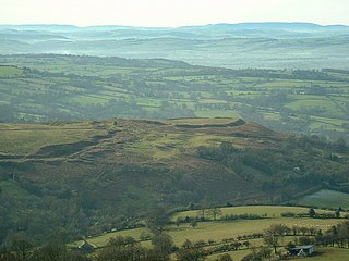
Oldbury Camp is the largest Iron Age hill fort in south-eastern England. It was built in the 1st century BC by Celtic British tribes on a hilltop west of Ightham, Kent, in a strategic location overlooking routes through the Kentish Weald. The fort comprises a bank and ditch enclosing an area of about 50 hectares, with entrances at the north-east and south ends. Wooden gates barred the entrances. Archaeological excavations carried out in the 1930s and 1980s found that the hill fort's interior had probably not been permanently occupied. It had been abandoned around 50 BC and the north-east gate had been burned down, possibly due to a Roman invasion. The wooded southern part of Oldbury Camp is now owned and managed by the National Trust and is open to the public.

<span class="mw-page-title-main">Liddington Castle</span> Hillfort in Wiltshire, England

Liddington Castle, locally called Liddington Camp, is a late Bronze Age and early Iron Age univallate hillfort in Liddington parish in the English county of Wiltshire, and a scheduled monument.

<span class="mw-page-title-main">Leintwardine</span> Human settlement in England

Leintwardine is a small to mid-size village and civil parish in north Herefordshire, England, close to the border with Shropshire.

<span class="mw-page-title-main">Maes Knoll</span> Iron Age hillfort in Somerset, England

Maes Knoll is an Iron Age hill fort in Somerset, England, located at the eastern end of the Dundry Down ridge, south of the city of Bristol and north of the village of Norton Malreward near the eastern side of Dundry Hill. It is a Scheduled Ancient Monument.

<span class="mw-page-title-main">Buckton and Coxall</span>

Buckton and Coxall is a civil parish in north Herefordshire, England.

<span class="mw-page-title-main">Nordy Bank</span> Iron Age hill fort in Shropshire, England

<span class="mw-page-title-main">Scratchbury Camp</span> Iron Age hillfort in Wiltshire, England

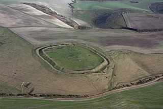
Scratchbury Camp is the site of an Iron Age univallate hillfort on Scratchbury Hill, overlooking the Wylye valley about 1 km northeast of the village of Norton Bavant in Wiltshire, England. The fort covers an area of 37 acres (15 ha) and occupies the summit of the hill on the edge of Salisbury Plain, with its four-sided shape largely following the natural contours of the hill.

<span class="mw-page-title-main">Brent Knoll Camp</span> Iron Age hillfort in Somerset, England

Brent Knoll Camp is an Iron Age hillfort at Brent Knoll, 3 kilometres (1.9 mi) from Burnham-on-Sea, Somerset, England. It has been designated as a Scheduled Monument, and is now in the care of the National Trust.

<span class="mw-page-title-main">Woodbury Hill</span>

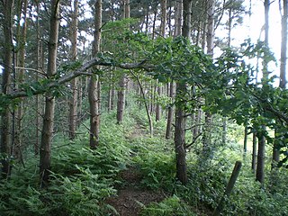
Woodbury Hill is a hill near the village of Great Witley, about 5 miles (8 km) south-west of Stourport-on-Severn in Worcestershire, England. It is the site of an Iron Age hillfort.

<span class="mw-page-title-main">Dinedor Camp</span>

Dinedor Camp is an Iron Age hillfort, about 1 kilometre (0.6 mi) west of the village of Dinedor and about 3 kilometres (1.9 mi) south of Hereford in England. It is a scheduled monument.

<span class="mw-page-title-main">Wadbury Camp</span> Promontory fort in Somerset, England

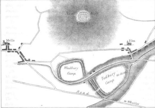
Wadbury Camp is a promontory fort in Somerset, England that protected the mining district of the Mendip Hills in pre-Roman times. It seems to have been an outwork of the larger Tedbury Camp.

<span class="mw-page-title-main">Holkham Camp</span>

Holkham Camp, or Holkham Fort, is an Iron Age fort in Norfolk, England, about 1 mile (1.6 km) north-west of the village of Holkham. It is a scheduled monument.

<span class="mw-page-title-main">Cadson Bury</span> Iron Age hillfort in Cornwall, England

Cadson Bury is an Iron Age hillfort about 2 miles (3.2 km) south-west of Callington, in Cornwall, England.

<span class="mw-page-title-main">Bury Walls</span> Iron Age hillfort in Shropshire, England

Bury Walls is an Iron Age hillfort about 1 mile (1.6 km) south-east of Weston-under-Redcastle, in Shropshire, England. It is a scheduled monument.

<span class="mw-page-title-main">Hollingbury Castle</span>

Hollingbury Castle, also known as Hollingbury Camp and Hollingbury Hillfort, is an Iron Age hillfort on the northern edge of Brighton, in East Sussex, England. It is adjacent to Hollingbury Park Golf Course.

<span class="mw-page-title-main">Aconbury Camp</span>

Aconbury Camp is an Iron Age hillfort on Aconbury Hill in Herefordshire, England, about 4 miles (6 km) south of Hereford, and near the village of Aconbury. It is a scheduled monument.

Dungeon Hill is an Iron Age hillfort, about 1+14 miles north of the village of Buckland Newton in Dorset, England. It is a scheduled monument.

<span class="mw-page-title-main">Thundersbarrow Hill</span>

Thundersbarrow Hill is an archaeological site in West Sussex, England. It is on a chalk ridge, aligned north-west to south-east, on the South Downs north of Shoreham-by-Sea.

Buckton Roman Fort is an archaeological site at Buckton, about 1 mile south-west of Leintwardine, in Herefordshire. England. it is a scheduled monument.

Brandon Camp is an archaeological site, about 1 mile south of Leintwardine, in Herefordshire. England. It is a hillfort of the Iron Age, which later became a Roman fort. The site is a scheduled monument.

References

  1. 1 2 3 4 5 Historic England. "Multiple enclosure hillfort on Coxall Knoll (1014107)". National Heritage List for England . Retrieved 13 April 2022.
  2. The Megalithic Portal and Megalith Map. "Coxall Knoll Hillfort : The Megalithic Portal and Megalith Map:". Megalithic.co.uk. Retrieved 13 April 2022.
  3. "Coxall Knoll" Hill Bagging. Retrieved 13 April 2022.
  4. 1 2 "Coxall Knoll" Roman Britain. Retrieved 13 April 2022.
  5. Historic England. "Coxall Knoll Camp (106821)". Research records (formerly PastScape). Retrieved 13 April 2022.