
The Battle of Badon /ˈbeɪdən/ also known as the Battle of Mons Badonicus was a battle purportedly fought between Britons and Anglo-Saxons in Post-Roman Britain in the late 5th or early 6th century. It was credited as a major victory for the Britons, stopping the encroachment of the Anglo-Saxon kingdoms for a period.
Little Solsbury Hill is a small flat-topped hill and the site of an Iron Age hill fort. It is located above the village of Batheaston in Somerset, England. The hill rises to 625 feet (191 m) above the River Avon, which is just over 1 mile (2 km) to the south, and gives views of the city of Bath and the surrounding area. It is within the Cotswolds Area of Outstanding Natural Beauty.

Badbury Rings is an Iron Age hill fort and Scheduled Monument in east Dorset, England. It was in the territory of the Durotriges. In the Roman era a temple was located immediately west of the fort, and there was a Romano-British town known as Vindocladia a short distance to the south-west.

Purton is a large village and civil parish in Wiltshire, England, about 4 miles (6 km) northwest of the centre of Swindon. The parish includes the village of Purton Stoke and the hamlets of Bentham, Hayes Knoll, Purton Common, Restrop, The Fox and Widham. The River Key, a tributary of the Thames, crosses the parish near Purton Stoke.

Oldbury Camp is the largest Iron Age hill fort in south-eastern England. It was built in the 1st century BC by Celtic British tribes on a hilltop west of Ightham, Kent, in a strategic location overlooking routes through the Kentish Weald. The fort comprises a bank and ditch enclosing an area of about 50 hectares, with entrances at the north-east and south ends. Wooden gates barred the entrances. Archaeological excavations carried out in the 1930s and 1980s found that the hill fort's interior had probably not been permanently occupied. It had been abandoned around 50 BC and the north-east gate had been burned down, possibly due to a Roman invasion. The wooded southern part of Oldbury Camp is now owned and managed by the National Trust and is open to the public.
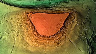
Liddington Castle, locally called Liddington Camp, is a late Bronze Age and early Iron Age univallate hillfort in the English county of Wiltshire, and a scheduled monument.

Stonea Camp is an Iron Age multivallate hill fort located at Stonea near March in the Cambridgeshire Fens. Situated on a gravel bank just 2 metres above sea-level, it is the lowest hill fort in Britain. Around 500 BC, when fortification is thought to have begun at this site, this "hill" would have provided a significant area of habitable land amidst the flooded marshes of the fens. The site exhibits at least two phases of development over several hundred years of settlement, with a D-shaped set of earth banks surrounded by a larger, more formal set of banks and ditches.

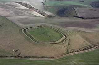
Yarnbury Castle is the site of a multiphase, multivallate Iron Age hillfort near the village of Steeple Langford, Wiltshire, England. The site covers an area of 28.5 acres (11.5 ha), and was extensively surveyed and investigated by the Royal Commission on the Historical Monuments of England in 1991, with finds of Iron Age and Romano-British pottery, Iron Age and Roman coins, and burials of human remains. There is much evidence of prolonged and extensive settlement of the site, including evidence of around 130 structures of various sizes, most probably representing a mix of round houses, pits, and other features. It was designated as a scheduled monument in 1925.

Figsbury Ring is an 11.2 hectare biological Site of Special Scientific Interest in Wiltshire, notified in 1975. It is owned and managed by the National Trust.

Braydon is a civil parish in north Wiltshire, England, about 6 miles (10 km) northwest of Swindon, between Purton and Minety. A thinly-populated farming area with no settlements apart from the farms, it is best known for sharing its name with Braydon Forest. The population of the parish was 48 in 1881 and was little changed in 2011, at 43.

Scratchbury Camp is the site of an Iron Age univallate hillfort on Scratchbury Hill, overlooking the Wylye valley about 1 km northeast of the village of Norton Bavant in Wiltshire, England. The fort covers an area of 37 acres (15 ha) and occupies the summit of the hill on the edge of Salisbury Plain, with its four-sided shape largely following the natural contours of the hill.

Bury Camp is the site of an Iron Age multivallate hillfort in north-west Wiltshire, England. It occupies a triangular promontory of Colerne Down, in the north of Colerne parish, at the southern edge of the Cotswold Hills between two spurs of a river valley. The enclosed area of approximately 9.2ha is surrounded by a ditch 4m wide and up to 1m deep, and an outer rampart up to 1.5m high on the east and northwestern sides and up to 2m high on the southwestern side, across the neck of the promontory.

Casterley Camp is the site of an Iron Age univallate hillfort in Wiltshire, England, about 1+1⁄2 miles (2.4 km) southwest of the village of Upavon. The site comprises a large Iron Age/Romano-British enclosure, possibly non-defensive in function, and incomplete. It was partially excavated in the 19th century.
Westbury Camp is a univallate Iron Age hill fort in the Mendip Hills in Somerset, England. The hill fort is situated in the parish of Rodney Stoke, approximately 1 mile (1.6 km) north-east of the village of Draycott and 1.5 miles (2.4 km) north-west of Westbury-sub-Mendip. The camp is largely situated in a hill slope. The north east defences have largely been destroyed by small quarries over the years. The narrow top of the hill bank suggests that it may have been surmounted by a dry stone wall. Along part of the east side of the camp there are traces of a berm between the bank and the outer ditch and at the western angle shallow quarry pits occur internally and externally set back from the 'rampart'.

Cholesbury Camp is a large and well-preserved Iron Age hill fort on the northern edge of the village of Cholesbury in Buckinghamshire, England. It is roughly oval-shaped and covers an area, including ramparts, of 15 acres (6.1 ha), and measures approximately 310 m (1,020 ft) north-east to south-west by 230 m (750 ft) north-west to south-east. The interior is a fairly level plateau which has been in agricultural use since the medieval period. The hill fort is now a scheduled ancient monument.
Membury Camp, or Membury Fort, is the site of an Iron Age hill fort located on the borders of Wiltshire and Berkshire,. The site encompasses 14 acres, and is situated in the south-western corner of a small plateau. The circular earthworks are completely shrouded in trees and inside the walls it is mostly arable farmland. To the northeast, in the Berkshire segment, the camp is totally wooded by a small copse, Walls Copse, which covers a quarter of the site. To the north and east the adjoining ground is flat, but to the south and west it falls away steeply, providing a natural defence. The camp consists of a single ditch with banks on either side and encloses and area measuring 390m by 490m. A gap in the east with inturning flanks is probably an original entrance though it is mutilated and overgrown. Other gaps in the banks appear to be more modern. A possible hut circle is visible as a cropmark situated at the south end of the hill fort. The east side of the earthwork has been partly destroyed by the construction of a wartime airfield, RAF Membury. The site has not been excavated but a number of prehistoric finds have been found in the vicinity. It is a scheduled ancient monument no. 228970 There have been several collections of pottery found, in 1977, 1980 and 1987 Other significant finds have also included for flint artefacts from the mesolithic era, and flint tools from the neolithic era, prior to the Iron Age.

Bratton Castle is a bivallate Iron Age built hill fort on Bratton Down, at the western edge of the Salisbury Plain escarpment. The hill fort comprises two circuits of ditch and bank which together enclose a pentagonal area of 9.3 hectares.

Limestone Corner is an area of Hadrian's Wall at its most northerly point, in present-day northern England. It represents the most northerly point of the Roman Empire, outside the two periods during which the Antonine Wall was occupied by the Roman military. Other notable features at Limestone Corner are the wall ditch at this point, which was never completely excavated, a Roman camp and the site of Milecastle 30. Also present is a trig point. The B6318 Military Road also runs through Limestone Corner, as does the Military Way, serving Milecastle 30. The Military Way is visible on the ground at this point, the most eastern point where this is the case.
Castle Rings is a univallate hill fort in the parish of Donhead St Mary in Wiltshire in England. The fort is a Scheduled Ancient Monument, with a list entry identification number of 1005698. Castle Rings has been dated to the Iron Age and is situated at an altitude of 228 metres (748 ft) upon Upper Greensand sandstone beds. The main bulk of the fort enclosure lies within the boundaries of Donhead St Mary parish but some of the outlying earthworks are situated in the neighbouring Sedgehill and Semley parish. In the mid-1980s a metal detectorist unearthed a hoard of stater coins of the Durotriges tribe within the hill fort.
Dungeon Hill is an Iron Age hillfort, about 1+1⁄4 miles north of the village of Buckland Newton in Dorset, England. It is a scheduled monument.

