Uley Bury

Last updated

View along the north-eastern rampart of Uley Bury, drawn by Edward J. Burrow in 1913 Print of Uley Bury Camp by EJ Burrow 1913.jpg
View along the north-eastern rampart of Uley Bury, drawn by Edward J. Burrow in 1913

Uley Bury is the long, flat-topped hill just outside Uley, Gloucestershire, England. It is an impressive multi-vallate, scarp-edge Iron Age hill fort dating from around 300 B.C. Standing some 750 feet (230 metres) above sea level it has views over the Severn Vale.

Contents

Location

farmer's Boundary Stone, Southern escarpment. 51.68601,-2.31515 / 51deg41'9.64"N+2deg18'54.53"W UleyBuryBS.jpg
farmer's Boundary Stone, Southern escarpment. 51.68601,-2.31515 / 51°41'9.64"N+2°18'54.53"W

Uley Bury is located at grid reference ST787992 ; ( 51°41.3′N2°18.7′W / 51.6883°N 2.3117°W / 51.6883; -2.3117 ).

The main access is from the Dursley to Stroud road (B4066) at Crawley Hill, just north of Uley. It can also be accessed from the Cotswold Way, and from several other local footpaths and bridleways.

Geology

3D view of the digital terrain model Uley Bury Digital Terrain Model.jpg
3D view of the digital terrain model

Uley Bury is a spur of the Cotswold escarpment, made up of thick beds of inferior oolitic limestone of the Jurassic period, overlying Bridport Sands. Part of the Bury is a Site of Special Scientific Interest (SSSI) famous for abundant fossils of Lower Jurassic age which occur here in the stratum known as the Cephalopod Bed . One particular horizon is especially noted for the ammonites it contains, which indicate that the strata are of early striatulum subzone age. Below in the Bridport Sand strata a thin, isolated sandstone layer contains what are elsewhere very rare ammonites, known as Haugia variabilis.

Archaeology

Uley Bury hill fort is a very large Iron Age settlement with evidence of occupation from approximately 300BC to 100AD; it covers 32 acres (13 hectares). It is one of a number of hillforts that can be seen along the Cotswold escarpment, other notable examples being Crickley Hill and Painswick Beacon.

The Bury is surrounded on all sides, apart from at the northern corner, by steep natural slopes. The hill fort was created by terracing a double line of ramparts – more than a mile in length overall - into the hillsides.

Excavations carried out on the north eastern rampart during the 1970s found evidence of how the ramparts were constructed. Finds during this excavation included a crouched burial, iron currency bars, quern stones, a brooch, and large amounts of pottery. Finds made at other times include a gold coin of the Dobunni, and a silver Roman coin.

Aerial photography has revealed extensive crop marks suggesting that there were once numerous dwellings in the interior of the hill fort; however, these have not yet been excavated.

Uley Bury is a Scheduled Ancient Monument. Hetty Pegler's Tump, a notable Neolithic long barrow, and West Hill, the site of a Romano-British temple, are both nearby.

Ecology

Uley Bury is an important wildlife habitat because of its unimproved limestone grassland, which has been created by centuries of grazing. The Bury lies in the Cotswold Area of Outstanding Natural Beauty (AONB) which holds a nationally significant concentration (52%) of all the unimproved Jurassic limestone grassland in the UK. A programme of regular summer grazing designed to conserve the grassland on the Bury was started in 2004. [1]

Related Research Articles

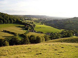
Uley is a village and civil parish in the county of Gloucestershire, England. The parish includes the hamlets of Elcombe and Shadwell and Bencombe, all to the south of the village of Uley, and the hamlet of Crawley to the north. The village is situated in a wooded valley in the Cotswold escarpment, on the B4066 road between Dursley and Stroud.

<span class="mw-page-title-main">Lambert's Castle</span> Historic hill fort in Dorset, England

Lambert's Castle is an Iron Age hillfort in the county of Dorset in southwest England. Since 1981 it has been designated as a Site of Special Scientific Interest (SSSI) on account of its geology, archaeology and ecology. The hillfort is designated a scheduled monument together with a bowl barrow, the sites of a post-medieval fair and a telegraph station. The site was on the Heritage at Risk Register but was removed in 2022 as a result of the Hillforts and Habitats Project.

<span class="mw-page-title-main">Scratchbury Camp</span> Iron Age hillfort in Wiltshire, England

Scratchbury Camp is the site of an Iron Age univallate hillfort on Scratchbury Hill, overlooking the Wylye valley about 1 km northeast of the village of Norton Bavant in Wiltshire, England. The fort covers an area of 37 acres (15 ha) and occupies the summit of the hill on the edge of Salisbury Plain, with its four-sided shape largely following the natural contours of the hill.

<span class="mw-page-title-main">Brassey SSSI</span> Biological Site of Special Scientific Interest in Gloucestershire, England

Brassey is a 2.1-hectare (5.2-acre) biological Site of Special Scientific Interest in Gloucestershire, notified in 1954 and renotified in 1983. It is situated on the north side of the Windrush Valley, midway between Naunton and Upper Slaughter. The reserve comprises sloping, unimproved limestone pasture. There is a fast-flowing stream. This site is one of the few freshwater marshes in Gloucestershire. The stream joins the River Windrush.

<span class="mw-page-title-main">Wotton Hill</span> Hill in Gloucestershire, England

Wotton Hill is a hill on the edge of the Cotswold Hills in Gloucestershire, England, 0.5 miles (0.80 km) north of Wotton-under-Edge. The Cotswold Way passes over the hill.

<span class="mw-page-title-main">Swift's Hill SSSI</span> Geological site in England

Swift's Hill is a 9.15-hectare (22.6-acre) biological and geological Site of Special Scientific Interest in Gloucestershire, notified in 1966 and renotified in 1984.

<span class="mw-page-title-main">Salmonsbury Meadows SSSI</span> English Site of Special Scientific Interest

Salmonsbury Meadows is an 18-hectare (44-acre) biological and geological Site of Special Scientific Interest in Gloucestershire, notified in 1985. The site is listed in the 'Cotswold District' Local Plan 2001-2011 as a Key Wildlife Site (KWS).

<span class="mw-page-title-main">Bull Cross, The Frith and Juniper Hill</span> Site of Special Scientific Interest in Gloucestershire, England

Bull Cross, The Frith and Juniper Hill is a 42.33-hectare (104.6-acre) biological and geological Site of Special Scientific Interest in Gloucestershire, notified in 1954. The site is listed in the ‘Stroud District’ Local Plan, adopted November 2005, Appendix 6 as an SSSI and Regionally Important Geological Site (RIGS).

<span class="mw-page-title-main">Cockleford Marsh</span> Biological Site of Special Scientific Interest in Gloucestershire, England

Cockleford Marsh is a 3.2-hectare (7.9-acre) biological Site of Special Scientific Interest in Gloucestershire, notified in 1991.

<span class="mw-page-title-main">Cotswold Commons and Beechwoods</span> Biological Site of Special Scientific Interest in Gloucestershire, England

Cotswold Commons and Beechwoods is a 665.5-hectare (1,644-acre) biological Site of Special Scientific Interest in Gloucestershire, notified in 1954.

<span class="mw-page-title-main">Crickley Hill and Barrow Wake</span> Site of Special Scientific Interest in Gloucestershire

Crickley Hill and Barrow Wake is a 56.8-hectare (140-acre) biological and geological Site of Special Scientific Interest in Gloucestershire, notified in 1974.

<span class="mw-page-title-main">Edge Common</span>

Edge Common is a 20.47-hectare (50.6-acre) biological Site of Special Scientific Interest in Gloucestershire, notified in 1974.

<span class="mw-page-title-main">Hornsleasow Roughs</span> Biological Site of Special Scientific Interest in Gloucestershire, England

Hornsleasow Roughs is a 28.24-hectare (69.8-acre) biological Site of Special Scientific Interest in Gloucestershire, notified in 1954.

<span class="mw-page-title-main">Juniper Hill, Edgeworth</span> Biological Site of Special Scientific Interest in Gloucestershire, England

Juniper Hill, Edgeworth is an 11.25-hectare (27.8-acre) biological Site of Special Scientific Interest in Gloucestershire, notified in 1974. The site is listed in the 'Cotswold District' Local Plan 2001-2011 as a Key Wildlife Site (KWS).

<span class="mw-page-title-main">Leckhampton Hill and Charlton Kings Common</span>

Leckhampton Hill and Charlton Kings Common is a 63.8-hectare (158-acre) biological and geological Site of Special Scientific Interest in Gloucestershire, notified in 1954. There are five units of assessment.

<span class="mw-page-title-main">Minchinhampton Common</span> Site of Special Scientific Interest in Gloucestershire

Minchinhampton Common is a 182.7-hectare (451-acre) biological and geological Site of Special Scientific Interest in Gloucestershire, notified in 1972.

<span class="mw-page-title-main">Puckham Woods</span> Biological Site of Special Scientific Interest in Gloucestershire, England

Puckham Woods is a 32.38-hectare (80.0-acre) biological Site of Special Scientific Interest in Gloucestershire to the east of Cheltenham near Whittington, notified in 1954. The site is listed in the 'Cotswold District' Local Plan 2001-2011 as a Key Wildlife Site (KWS).

<span class="mw-page-title-main">Range Farm Fields</span> Biological Site of Special Scientific Interest in Gloucestershire, England

Range Farm Fields is a 12.8-hectare (32-acre) biological Site of Special Scientific Interest in Gloucestershire, near to Gloucester City, notified in 1996.

<span class="mw-page-title-main">Rodborough Common, Gloucestershire</span> Biological and geological Site of Special Scientific Interest in Gloucestershire, United Kingdom

Rodborough Common is a 116.0-hectare (287-acre) biological and geological Site of Special Scientific Interest in Gloucestershire, notified in 1954. The site is listed in the ‘Stroud District’ Local Plan, adopted November 2005, Appendix 6 as an SSSI and a Regionally Important Geological Site (RIGS). The Common is also a Special Area of Conservation (SAC) under the EU Habitats Directive

<span class="mw-page-title-main">Kimsbury hill fort</span>

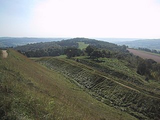
Kimsbury hill fort, also known as Castle Godwyn, Kimsbury Camp, Painswick Beacon or Painswick hill fort is an Iron Age hill fort on Painswick Beacon near Painswick in the Cotswolds, Gloucestershire England.

References

  1. "unimproved limestone Grassland" (PDF). web.archive.org Wayback Machine. Retrieved 22 January 2024.

Further reading