Eggardon Hill

Last updated

Eggardon Hill
Eggardon hill from south east 19Mar2006.jpg
Eggardon Hill from the southeast
Highest point
Elevation 252 m (827 ft) [1]
Prominence 115 m (377 ft) [1]
Listing Hardy
Coordinates 50°45′00″N2°39′02″W / 50.75008°N 2.650572°W / 50.75008; -2.650572
Geography
Location Dorset, England
Parent range Dorset Downs
OS grid SY541947
Topo map OS Landranger 194

Eggardon Hill is a prehistoric hillfort on a hill in Dorset, England. It is located on chalk uplands approximately four miles to the east of the town of Bridport.

Contents

The Hill

Eggardon Hill stands 252 metres (827 ft) above sea level and is classified as a Hump (hill of any height with a drop of 100 metres or more on all sides). The highest point is to the east of the hillfort, [1] (some sources give a height of 254m [2] [3] ). The hill provides extensive views of the surrounding countryside and the English Channel to the south. The southern half of the hill is owned and maintained by The National Trust (which permits free public access throughout the year) with the northern part in private ownership. [4]

Prehistory

The earliest archaeological features on the hill are linear earthworks which cross the interior. These were partially excavated during 1963-6 and found to be Bronze Age. There are also two bowl barrows within the area of the hillfort that were dated to the Middle Bronze Age. [5] There are also three further bowl barrows and a disc barrow on the top of the hill outside of the area of the hillfort. [6] [7]

The large multivallate hillfort dates from the Iron Age. The surviving earthworks enclose an area of approximately 21ha in total. The defences consist of three ramparts with two medial ditches with additional outer banks to the north-west and east. Ditches and counterscarp banks provide additional protection at the staggered entrances and to the south west where there is an additional outwork. [5]

Later history

The Hundred of Eggardon is first documented in the Domesday Book of 1086. [8]

The name Eggardon is derived from an Old English place name, meaning the hill belonging to Eohhere. [9]

The smuggler Isaac Gulliver (1745-1822) (who owned Eggardon Hill Farm) is reputed to have planted a stand of pine trees on Eggardon Hill, to provide an aid to navigation for his ships as they approached the Dorset coast. Although the trees were later felled on government orders, the octagonal earthworks used to protect them from the elements is still visible today and marked on Ordnance Survey maps of the area. [10]

Preservation

Eggardon Hill from the South West, August 2009 Eggardon Hill from southwest.JPG
Eggardon Hill from the South West, August 2009

The Hillfort and the two bowl barrows within it are a scheduled monument. [5] The group of three bowl barrows and the disc barrow outside of the hillfort are scheduled separately. [6] [7]

The southern half of the hill is owned and maintained by The National Trust (which permits free public access throughout the year) with the northern part in private ownership. [4]

Related Research Articles

Hambledon Hill is a prehistoric hill fort in Dorset, England, in the Blackmore Vale five miles northwest of Blandford Forum. The hill itself is a chalk outcrop, on the southwestern corner of Cranborne Chase, separated from the Dorset Downs by the River Stour. It is owned by the National Trust.

<span class="mw-page-title-main">Badbury Rings</span> Iron Age hill fort in east Dorset, England

Badbury Rings is an Iron Age hill fort and Scheduled Monument in east Dorset, England. It was in the territory of the Durotriges. In the Roman era a temple was located immediately west of the fort, and there was a Romano-British town known as Vindocladia a short distance to the south-west.

<span class="mw-page-title-main">Hod Hill</span> Hillfort in Dorset, England

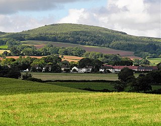
Hod Hill is a large hill fort in the Blackmore Vale, 3 miles (5 km) north-west of Blandford Forum, Dorset, England. The fort sits on a 143 m (469 ft) chalk hill of the same name that lies between the adjacent Dorset Downs and Cranborne Chase. The hill fort at Hambledon Hill is just to the north. The name probably comes from Old English "hod", meaning a shelter, though "hod" could also mean "hood", referring to the shape of the hill.

<span class="mw-page-title-main">Small Down Knoll</span> Bronze Age hillfort in Somerset, England

Small Down Knoll, or Small Down Camp, is a Bronze Age hill fort near Evercreech in Somerset, England. The hill is on the southern edge of the Mendip Hills, and rises to 222 m (728 ft).

<span class="mw-page-title-main">Askerswell</span> Village in Dorset, England

Askerswell is a small village and civil parish in the county of Dorset in southwest England. It is sited on the small River Asker. It lies 11 miles (18 km) west of the county town Dorchester. The parish has an area of 1,724 acres and in the northeast includes the western slopes of Eggardon Hill, including part of the Iron Age hill fort close to its summit. In the 2011 census the civil parish had a population of 154.

<span class="mw-page-title-main">Coney's Castle</span> Iron Age hillfort in Dorset, England

Coney's Castle is an Iron Age hillfort in Dorset, England. The name Coney is from the Old English for rabbit, suggesting medieval use as a domestic warren, as at nearby Pilsdon Pen.

<span class="mw-page-title-main">Lambert's Castle</span> Historic hill fort in Dorset, England

Lambert's Castle is an Iron Age hillfort in the county of Dorset in southwest England. Since 1981 it has been designated as a Site of Special Scientific Interest (SSSI) on account of its geology, archaeology and ecology. The hillfort is designated a scheduled monument together with a bowl barrow, the sites of a post-medieval fair and a telegraph station. The site was on the Heritage at Risk Register but was removed in 2022 as a result of the Hillforts and Habitats Project.

<span class="mw-page-title-main">Dowsborough</span> Hillfort in Somerset

Dowsborough Camp is an Iron Age hill fort on the Quantock Hills near Nether Stowey in Somerset, England. It has been designated as a Scheduled Monument. The fort and associated round barrow has been added to the Heritage at Risk Register due to vulnerability to vehicle damage and erosion.

<span class="mw-page-title-main">Kelsborrow Castle</span> Iron Age hillfort in Cheshire, England

Kelsborrow Castle is an Iron Age hill fort in Cheshire, northern England. Hill forts were fortified hill-top settlements constructed across Britain during the Iron Age. It is one of only seven hill forts in the county of Cheshire and was probably in use for only a short time. In the 19th century, a bronze palstave was recovered from the site. It is protected as a Scheduled Ancient Monument.

<span class="mw-page-title-main">Ladle Hill</span> Hill in Hampshire, England

Ladle Hill is a 10.5-hectare (26-acre) biological Site of Special Scientific Interest west of Kingsclere in Hampshire. It is also a Scheduled Monument.

<span class="mw-page-title-main">Scratchbury Camp</span> Iron Age hillfort in Wiltshire, England

Scratchbury Camp is the site of an Iron Age univallate hillfort on Scratchbury Hill, overlooking the Wylye valley about 1 km northeast of the village of Norton Bavant in Wiltshire, England. The fort covers an area of 37 acres (15 ha) and occupies the summit of the hill on the edge of Salisbury Plain, with its four-sided shape largely following the natural contours of the hill.

<span class="mw-page-title-main">Promontory forts of Cornwall</span> Cliff castles in north-west Europe

Cornish promontory forts, commonly known in Cornwall as cliff castles, are coastal equivalents of the hill forts and Cornish "rounds" found on Cornish hilltops and slopes. Similar coastal forts are found on the north–west European seaboard, in Normandy, Brittany and around the coastlines of the British Isles, especially in Wales, Scotland and Ireland. Many are known in southwest England, particularly in Cornwall and its neighbouring county, Devon. Two have been identified immediately west of Cornwall, in the Isles of Scilly.

<span class="mw-page-title-main">Warbstow Bury</span> Iron Age hillfort in Cornwall, England

Warbstow Bury is an Iron Age hillfort about 0.5 miles (0.80 km) west of the village of Warbstow, in Cornwall, England. It is a scheduled monument.

<span class="mw-page-title-main">Chalbury Hillfort</span> Iron Age hillfort in Dorset, England

Chalbury Hillfort is an Iron Age hillfort about 1 mile (1.6 km) south-east of the village of Bincombe, in Dorset, England. It is a scheduled monument.

<span class="mw-page-title-main">Martin Down Enclosure</span>

The Martin Down Enclosure is an archaeological site on Martin Down, near the village of Martin, in Hampshire, England. It is near the boundaries with Dorset and Wiltshire.

<span class="mw-page-title-main">Thundersbarrow Hill</span>

Thundersbarrow Hill is an archaeological site in West Sussex, England. It is on a chalk ridge, aligned north-west to south-east, on the South Downs north of Shoreham-by-Sea.

West Somerset was a local government district in the English county of Somerset. It merged with Taunton Deane to form Somerset West and Taunton on 1 April 2019.

References

  1. 1 2 3 Eggardon Hill at the online Database of British and Irish Hills. Accessed on 22 Mar 2013.
  2. Jackson, Mark. "More Relative Hills of Britain" (PDF). Relative Hills of Britain. Archived from the original (PDF) on 12 October 2013. Retrieved 9 September 2011.
  3. Summit Listings by Relative Height by Jonathan de Ferranti. Accessed on 25 Mar 2013.
  4. 1 2 "Eggardon Hill". National Trust. Retrieved 6 December 2021.
  5. 1 2 3 Historic England. "Large multivallate hillfort containing two bowl barrows 855m north east of North Eggardon Farm, Askerswell (1002684)". National Heritage List for England . Retrieved 6 December 2021.
  6. 1 2 Historic England. "Group of three round barrows on Eggardon Hill, Powerstock (1002822)". National Heritage List for England . Retrieved 6 December 2021.
  7. 1 2 Historic England. "Eggardon Hill disc barrow, Powerstock (1003060)". National Heritage List for England . Retrieved 6 December 2021.
  8. "Hundred of Eggardon | Domesday Book". opendomesday.org. Retrieved 6 December 2021.
  9. "Eggardon Hill, North Eggardon Fm & South Eggardon Fm :: Survey of English Place-Names". epns.nottingham.ac.uk. Retrieved 6 December 2021.
  10. "MNA137040 | National Trust Heritage Records". heritagerecords.nationaltrust.org.uk. Retrieved 6 December 2021.