
Marne is a department in the Grand Est region of France. It is named after the river Marne which flows through it. The prefecture (capital) of Marne is Châlons-en-Champagne. The subprefectures are Épernay, Reims, and Vitry-le-François.
Chichawatni is a city in the Sahiwal District of the Pakistani province of Punjab. Situated near the old main road called Grand Trunk Road, it lies approximately 45 kilometres (28 mi) from the district capital, Sahiwal. In 2011, Chichawatni's population was estimated at approximately 160,000.
Nicola Lake is a glacially formed narrow, deep lake located in the South-Central Interior of British Columbia, Canada approximately thirty kilometres northeast of the city of Merritt. It was a centrepoint of the first settlements in the grasslands lying south of Kamloops, and today is used for recreation and as a water storage site to provide irrigation and water flows to fisheries downstream in the Nicola River. The lake is important in the history of the local Nicola people as the location of one of their major communities, Nicola Lake Indian Reserve No. 1, which lies on its eastern shore and is the home of the Upper Nicola Indian Band. Many of the band work for the Douglas Lake Cattle Company, aka the Douglas Lake Ranch, whose headquarters are also adjacent to the lake.

Lockerley is a village and civil parish in Hampshire, England on the border with Wiltshire. The village lies on the southern bank of the River Dun about two miles upstream from its confluence with the River Test and about 4 kilometres (2.5 mi) east of West Dean which is just over the Wiltshire border. The parish has a population of around 827 people. The nearest town is Romsey, about 8 kilometres (5 mi) to the south-east and is about 13 miles from Salisbury.

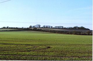
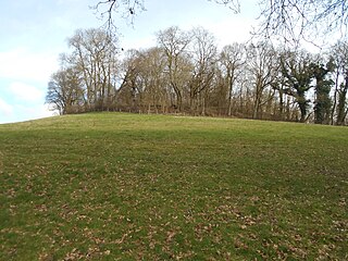
Ladle Hill is a 10.5-hectare (26-acre) biological Site of Special Scientific Interest west of Kingsclere in Hampshire. It is also a Scheduled Monument.

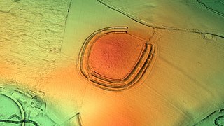
The Frith is a small univallate Iron Age hillfort to the north of Silchester, Calleva Atrebatum, Roman town in the English county of Hampshire. A single bank covers all sides apart from the south east, and is at the most about 5 feet (1.5 m) high on the western edge. A ditch is also traceable for the length of the bank, although at varying states.
Bullsdown Camp is the site of a former Iron Age plateau fort in the County of Hampshire. The site is heavily wooded, and close inspection is required to observe the three bank and ditch fortifications. Although eroded heavily the earthworks are still impressive
Frankenbury Camp is the site of an Iron Age univallate hillfort located in Hampshire. The site is on a very slight promontory overlooking the Avon Valley on the north-western edge of the New Forest. The fort encloses approximately 11 acres. It has very steep natural slopes on the west and south sides. The northeast sides are defended by a simple rampart and ditch. The original entrance on the southeast corner has since been widened. It is listed as a scheduled ancient monument no.122. The site is currently pasture, and part of Folds Farm, for the most part, although the earthworks themselves are lined with trees and the south and western parts are now encroached by woodland. Various archaeological relics have been found in the area:

Hamble Common Camp is the site of an Iron Age promontory hillfort located in Hampshire. The fort is located on Hamble common on a peninsula of land formed between Southampton Water and the River Hamble. The site was later occupied by St Andrews castle, one of the Device Forts built by King Henry VIII.
Knoll Camp, or Damerham Knoll, is the site of an Iron Age univallate hill fort located in Hampshire. The fort comprises a circular earthwork containing about four acres. There is a single ditch with inner rampart and traces of counter scarp bank. The site is a scheduled ancient monument no.118. Grim's Ditch also runs throughout this area. The footpath/bridleway from the nearby long barrows of Grans Barrow and Knap Barrow runs southeast along the ridge through the centre of the hill fort, leaving through the original SE entrance, and you could easily miss the ditch and bank as you cross it. The interior is thickly wooded and brambled.

Norsebury Ring is the site of an Iron Age univallate hillfort located in Hampshire. Now mostly ploughed out to the South and east, some ditches and ramparts remain within a small copsed area to the North and west, which are surprisingly intact with a small outer ditch, then a bank, then another larger ditch followed by larger bank. However the trees and undergrowth hide the earthworks from immediate view.
Quarley Hill is the site of an Iron Age univallate hill fort in Hampshire, southern England. The hill affords commanding views of the surrounding countryside.

Tidbury Ring is the site of an Iron Age univallate hillfort located in Hampshire. The earthworks have been heavily destroyed by ploughing, but some sections to the south remain in better condition. The entrance lies to the southeast of the fort. The interior is for the most part farmland with the earthworks now covered by small trees and undergrowth Two Roman buildings, possibly a courtyard villa complex were found within the hill-fort. The site is now listed as a scheduled ancient monument no.87

Toothill Fort, or Toothill Ring, or Toothill camp, is the site of an Iron Age univallate hill fort located in Hampshire. The site occupies an extremely strong position at the north end of a spur. Its defences comprise a single rampart and ditch with traces of a counterscarp bank in places. There is an additional scarp on the north side up to 2.0m in height where the site is weakest. The original entrance is onto the ridge to the south.

Whitsbury Castle, or Whitsbury Castle Ditches, is the site of an Iron Age univallate hillfort located near the village of Whitsbury in Hampshire. The fort is roughly pear-shaped, located on a chalk outcrop, and covering approximately sixteen acres. The defenses comprise two large ramparts with outer ditches and an additional counter scarp bank on the northern half. The original entrance was at the southwestern corner but has been destroyed by the construction of a post-medieval manor house. The site has been in use throughout the ages, with excavation revealing mesolithic activity, an association with a Bronze Age ranch boundary, an Iron Age hillfort settlement, followed much later by Anglo-Saxon renovation and reuse of the defences. The site is privately owned but is flanked externally on all sides but east by public bridleways.

Woolbury, or Woolbury Ring, is the site of an Iron Age univallate hill fort on Stockbridge Down, Hampshire, England.

Bussock Camp is the site of an Iron Age bivallate hillfort located in Berkshire, England. It has a double bank and ditch to the south and east, with only a single bank remaining the north and western sides. The entrance is to the north of the site and is believed to be original, and the site encloses approximately 11 acres.
Perborough Castle is the site of an Iron Age univallate hillfort located at Compton in Berkshire. The site covers approximately 14 acres (5.7 ha), and lies on the chalky downs of West Berkshire. Archaeological evidence, from excavations in 1838, suggest that it was a lightly defended and perhaps a seasonally occupied site, containing no more than a few grain storage pits and slag pits, the extent of these being the obvious sign of continued occupation.
King John's Hill is the site of an Iron Age hillfort located in Hampshire, in southeast England. The hill is situated in the parish of Worldham, in East Hampshire District. It is a Scheduled Ancient Monument with a list entry identification number of 1020314, and a Monument Number of 243207.
The Ardristan standing stones are two menhirs near Tullow, County Carlow.
