Edgemoor, Delaware

Last updated
Edgemoor, Delaware
CDP
New Castle County Delaware incorporated and unincorporated areas Edgemoor highlighted.svg
Location in New Castle County and the state of Delaware
USA Delaware location map.svg
Red pog.svg
Edgemoor
Location within the state of Delaware
Usa edcp location map.svg
Red pog.svg
Edgemoor
Edgemoor (the United States)
Coordinates: 39°45′00″N75°29′59″W / 39.75000°N 75.49972°W / 39.75000; -75.49972 Coordinates: 39°45′00″N75°29′59″W / 39.75000°N 75.49972°W / 39.75000; -75.49972
Country United States
State Delaware
County New Castle
Area
[1]
  Total2.18 sq mi (5.64 km2)
  Land1.92 sq mi (4.97 km2)
  Water0.26 sq mi (0.67 km2)
Elevation
30 ft (9 m)
Population
 (2020)
  Total6,635
  Density3,459.33/sq mi (1,335.45/km2)
Time zone UTC-5 (Eastern (EST))
  Summer (DST) UTC-4 (EDT)
ZIP codes
19802, 19809, 19810
Area code 302
FIPS code 10-23240
GNIS feature ID213930 [2]

Edgemoor is a census-designated place in New Castle County, Delaware, United States. The population was 5,677 at the 2010 census.

Contents

Geography

Edgemoor is located at 39°45′00″N75°29′59″W / 39.75000°N 75.49972°W / 39.75000; -75.49972 (39.7501139, -75.4996414). [3]

According to the United States Census Bureau, the CDP has a total area of 1.8 square miles (4.7 km2), of which 1.8 square miles (4.7 km2) is land and 0.55% is water.

History

Edgemoor was originally developed as a village by the Edgemoor Iron Company in 1871. [4]

Demographics

Historical population
CensusPop.
1980 7,397
1990 5,853−20.9%
2000 5,9922.4%
2010 5,677−5.3%
2020 6,63516.9%
source: [5]

As of the census [6] of 2000, there were 5,992 people, 2,507 households, and 1,566 families living in the CDP. The population density was 3,288.3 inhabitants per square mile (1,269.6/km2). There were 2,851 housing units at an average density of 1,564.6 per square mile (604.1/km2). The racial makeup of the CDP was 62.27% White, 33.58% African American, 0.20% Native American, 1.15% Asian, 0.02% Pacific Islander, 0.98% from other races, and 1.80% from two or more races. Hispanic or Latino people of any race were 2.72% of the population.

There were 2,507 households, out of which 32.7% had children under the age of 18 living with them, 38.1% were married couples living together, 19.5% had a female householder with no husband present, and 37.5% were non-families. 31.8% of all households were made up of individuals, and 9.2% had someone living alone who was 65 years of age or older. The average household size was 2.38 and the average family size was 3.02.

In the CDP, the population was spread out, with 28.2% under the age of 18, 6.9% from 18 to 24, 32.5% from 25 to 44, 21.5% from 45 to 64, and 10.9% who were 65 years of age or older. The median age was 35 years. For every 100 females, there were 85.1 males. For every 100 females age 18 and over, there were 79.3 males.

The median income for a household in the CDP was $39,931, and the median income for a family was $45,903. Males had a median income of $36,957 versus $29,675 for females. The per capita income for the CDP was $22,081. About 13.4% of families and 15.0% of the population were below the poverty line, including 31.1% of those under age 18 and 1.2% of those age 65 or over.

Education

Edgemoor is in the Brandywine School District. [7]

Related Research Articles

<span class="mw-page-title-main">Highland Acres, Delaware</span> CDP in Delaware, United States

Highland Acres is a census-designated place (CDP) in Kent County, Delaware, United States. It is part of the Dover, Delaware Metropolitan Statistical Area. The population was 3,459 at the 2010 census.

<span class="mw-page-title-main">Kent Acres, Delaware</span> CDP in Delaware, United States

Kent Acres is a census-designated place (CDP) in Kent County, Delaware, United States. It is part of the Dover, Delaware Metropolitan Statistical Area. The population was 1,890 at the 2010 census.

<span class="mw-page-title-main">Riverview, Delaware</span> CDP in Delaware, United States

Riverview is a census-designated place (CDP) in Kent County, Delaware, United States. It is part of the Dover, Delaware Metropolitan Statistical Area. The population was 2,456 at the 2010 census.

<span class="mw-page-title-main">Rodney Village, Delaware</span> CDP in Delaware, United States

Rodney Village is a census-designated place (CDP) in Kent County, Delaware, United States. It is part of the Dover, Delaware Metropolitan Statistical Area. The population was 1,487 at the 2010 census.

<span class="mw-page-title-main">Woodside East, Delaware</span> CDP in Delaware, United States

Woodside East is a census-designated place (CDP) in Kent County, Delaware, United States. It is part of the Dover, Delaware Metropolitan Statistical Area. The population was 2,316 at the 2010 census.

<span class="mw-page-title-main">Brookside, Delaware</span> CDP in Delaware, United States

Brookside is a census-designated place (CDP) in New Castle County, Delaware, United States. The population was 14,353 at the 2010 census.

<span class="mw-page-title-main">Glasgow, Delaware</span> CDP in Delaware, United States

Glasgow is a census-designated place (CDP) in New Castle County, Delaware, United States. The population was 14,303 at the 2010 census.

<span class="mw-page-title-main">Wilmington Manor, Delaware</span> CDP in Delaware, United States

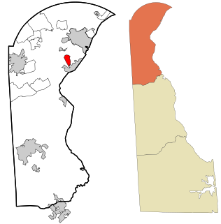
Wilmington Manor is a census-designated place (CDP) in north-eastern New Castle County, Delaware, United States. The population was 7,889 at the 2010 census.

<span class="mw-page-title-main">Eden, Maryland</span> CDP in Maryland, United States

Eden is a census-designated place (CDP) in Somerset County, Maryland, United States. The Eden zip code (21822) also includes parts of Wicomico and Worcester counties. The population was 793 at the 2000 census. It is included in the Salisbury, Maryland-Delaware Metropolitan Statistical Area.

<span class="mw-page-title-main">Frenchtown-Rumbly, Maryland</span> CDP in Maryland, United States

Frenchtown-Rumbly is a census-designated place in Somerset County, Maryland, United States. The population was 96 at the 2000 census. It is included in the Salisbury, Maryland-Delaware Metropolitan Statistical Area.

<span class="mw-page-title-main">Mount Vernon, Maryland</span> CDP in Maryland, United States

Mount Vernon is a census-designated place (CDP) in Somerset County, Maryland, United States. The population was 761 at the 2000 census. It is included in the Salisbury, Maryland-Delaware Metropolitan Statistical Area.

<span class="mw-page-title-main">West Pocomoke, Maryland</span> CDP in Maryland, United States

West Pocomoke is a census-designated place (CDP) in Somerset County, Maryland, United States. The population was 498 at the 2000 census. It is included in the Salisbury, Maryland-Delaware Metropolitan Statistical Area.

<span class="mw-page-title-main">West Ocean City, Maryland</span> CDP in Maryland, United States

West Ocean City is a census-designated place (CDP) in Worcester County, Maryland, United States. The population was 4,375 at the 2010 census. It is part of the Salisbury, Maryland-Delaware Metropolitan Statistical Area.

<span class="mw-page-title-main">Whaleyville, Maryland</span> CDP in Maryland, United States

Whaleyville is a census-designated place in Worcester County, Maryland, United States. The population was 149 at the 2010 census. It is part of the Salisbury, Maryland-Delaware Metropolitan Statistical Area.

<span class="mw-page-title-main">Rising Sun-Lebanon, Delaware</span> CDP in Delaware, United States

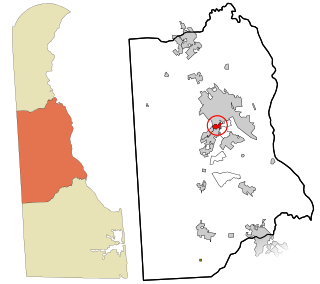
Rising Sun-Lebanon is a census-designated place (CDP) in Kent County, Delaware, United States. It is part of the Dover, Delaware Metropolitan Statistical Area. The population was 3,391 at the 2010 census.

<span class="mw-page-title-main">Boothwyn, Pennsylvania</span> Census-designated place in Pennsylvania, United States

Boothwyn is a census-designated place (CDP) in Delaware County, Pennsylvania, United States. The population was 4,933 at the 2010 census, down from 5,206 at the 2000 census. The census estimation for population circa 2019 is 6,115.

<span class="mw-page-title-main">Broomall, Pennsylvania</span> Census-designated place in Pennsylvania, United States

Broomall is a census-designated place (CDP) in Marple Township, Delaware County, Pennsylvania, United States. The population was 10,789 at the 2010 census.

<span class="mw-page-title-main">Folsom, Pennsylvania</span> Census-designated place in Pennsylvania, United States

Folsom is a census-designated place (CDP) in Delaware County, Pennsylvania, United States. It is part of Ridley Township. The population was 8,323 at the 2010 census.

<span class="mw-page-title-main">Lima, Pennsylvania</span> Census-designated place in Pennsylvania, United States

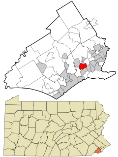
Lima is an unincorporated community and census-designated place (CDP) in Middletown Township, Delaware County, Pennsylvania, United States. The population was 2,735 at the 2010 census, down from 3,225 at the 2000 census. It is pronounced "LYE-ma" (/ˈɫaɪ-mə/).

<span class="mw-page-title-main">Village Green-Green Ridge, Pennsylvania</span> Census-designated place in Pennsylvania, United States

Village Green-Green Ridge is a census-designated place (CDP) in Delaware County, Pennsylvania, United States. The population was 7,822 at the 2010 census, down from 8,279 at the 2000 census.

References

  1. "2020 U.S. Gazetteer Files". United States Census Bureau. Retrieved October 31, 2021.
  2. "Edgemoor". Geographic Names Information System . United States Geological Survey, United States Department of the Interior.
  3. "US Gazetteer files: 2010, 2000, and 1990". United States Census Bureau. 2011-02-12. Retrieved 2011-04-23.
  4. Project, Delaware Federal Writers' (1955). Delaware: A Guide to the First State. ISBN   9781603540087.
  5. "CENSUS OF POPULATION AND HOUSING (1790-2000)". U.S. Census Bureau . Retrieved 2010-07-17.
  6. "U.S. Census website". United States Census Bureau . Retrieved 2008-01-31.
  7. "2020 CENSUS - SCHOOL DISTRICT REFERENCE MAP: New Castle County, DE" (PDF). U.S. Census Bureau . Retrieved 2021-06-18.