Claymont is a census-designated place (CDP) in New Castle County, Delaware. As of the 2020 U.S. census, the population of Claymont was 9,895.
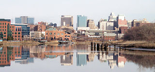
Wilmington is the largest city in the U.S. state of Delaware. The city was built on the site of Fort Christina, the first Swedish settlement in North America. It lies at the confluence of the Christina River and Brandywine Creek, near where the Christina flows into the Delaware River. It is the county seat of New Castle County and one of the major cities in the Delaware Valley metropolitan area. Wilmington was named by Proprietor Thomas Penn after his friend Spencer Compton, Earl of Wilmington, who was prime minister during the reign of George II of Great Britain.

The Hagley Museum and Library is a nonprofit educational institution in unincorporated New Castle County, Delaware, near Wilmington. Covering more than 235 acres (95 ha) along the banks of the Brandywine Creek, the museum and grounds include the first du Pont family home and garden in the United States, the powder yards, and a 19th-century machine shop. On the hillside below the mansion lies a Renaissance Revival garden, with terraces and statuary, created in the 1920s by Louise Evelina du Pont Crowninshield (1877–1958).

Delaware Route 141 (DE 141) is a state highway that serves as a western bypass of Wilmington, Delaware. Its southern terminus is at DE 9 and DE 273 in New Castle and its northern terminus is an interchange with U.S. Route 202 (US 202) and DE 261 near Fairfax. The route heads north from DE 9 and DE 273 on four-lane divided Basin Road, becoming concurrent with US 202 at an interchange with US 13/US 40 in Wilmington Manor, and passes to the east of Wilmington Airport. The highway becomes a freeway and reaches an interchange with Interstate 95 (I-95) and I-295, at which point US 202 splits from DE 141. The DE 141 freeway continues north through Newport to Prices Corner. Here, the freeway segment ends and DE 141 continues northeast as a surface road, with another brief freeway segment in Greenville. The route heads east across the Brandywine Creek on the Tyler-McConnell Bridge and continues to US 202 and DE 261.

Brandywine Creek State Park is a state park, located 3 miles (4.8 km) north of Wilmington, Delaware along the Brandywine Creek. Open year-round, it is 933 acres (378 ha) in area and much of the park was part of a Du Pont family estate and dairy farm before becoming a state park in 1965. It contains the first two nature preserves in Delaware. These nature preserves are Tulip Tree Woods and Freshwater Marsh. Flint Woods is a satellite area of the park and has become the park's third nature preserve. Flint Woods is home to species of rare song birds and an old-growth forest. The park's forests are part of the Northeastern coastal forests ecoregion.
Gwinhurst is an unincorporated community in New Castle County, Delaware, United States in the Philadelphia-Camden-Wilmington Metropolitan Statistical Area.

Wilmington State Parks is a state park located in Wilmington, Delaware. Open year-round, the park is approximately 345 acres (140 ha) of land mostly situated along the Brandywine Creek. The state park is made up of a group of smaller parks that are administratively managed as a single unit.

Bellevue State Park is a 328-acre (133 ha) Delaware state park in the suburbs of Wilmington in New Castle County, Delaware in the United States. The park is named for Bellevue Hall, the former mansion of William du Pont Jr. Many of the facilities at the park were built by du Pont. Bellevue State Park overlooks the Delaware River and is open for year-round recreation, daily, from 8 a.m. until sunset. The Mount Pleasant Methodist Episcopal Church and Parsonage is located in Bellevue State Park; it was added to the National Register of Historic Places in 1998. Cauffiel House is a historic home in the park near Stoney Creek.

Beaver Valley straddles the Pennsylvania and Delaware border in Delaware County, PA and New Castle County, DE. An unincorporated place name, it is traversed by several streams which drain to Beaver Run which itself empties into the Brandywine River. It is approximately bounded by US Route 202 to the east, The Brandywine River to the west, Thompsons Bridge Road to the south, and Smithbridge Road to the north, with Beaver Valley Road encircling a large portion of the valley.
Tavistock is an unincorporated community in New Castle County, Delaware, United States. It is within ZIP Code Tabulation Area for 19803.
Sharpley is an unincorporated community in New Castle County, Delaware, United States in the Brandywine Hundred. It is within ZIP Code Tabulation Area for 19803.
Edenridge is an unincorporated community in New Castle County, Delaware, United States in the Brandywine Hundred, north of Wilmington.

William Young House is a historic home located near Rockland, New Castle County, Delaware. The house was added to the National Register of Historic Places in 1982.

Augustine Paper Mill, also known as the Container Corporation of America, Paper Mill Division, was a historic paper mill complex located in Wilmington, New Castle County, Delaware. The complex consisted of seven 19th century stone buildings including the original three-story mill building, also known as Building 7, and various later two-level mill structures and support buildings. As of 2022, Building 7 is the only surviving part of the complex. It is a three-story mill erected from randomly laid stone with walls three feet thick, a slate covered gable roof, and an arched brick opening for the mill race.
William Poole Bancroft was an American industrialist who later became an important figure in the land conservation movement. His belief that the beauty of the Brandywine region should be protected against urban sprawl for future generations led to him purchasing large amounts of land which eventually became state and federally owned park land.
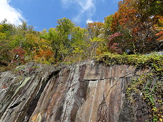
Alapocas Run State Park is a state park, located in Wilmington, Delaware, United States, along the Brandywine Creek and its Alapocas Run tributary. Open year-round, it is 415 acres (168 ha) in area. Much of the state park was created from land originally preserved by William Poole Bancroft in the early 1900s to be used as open space parkland by the city of Wilmington as it expanded. The park also includes the Blue Ball Barn, a dairy barn built by Alfred I. du Pont as part of his Nemours estate in 1914. In addition to walking trails, athletic fields, and playgrounds for children, one of the park's primary features is a rock climbing wall. The rock climbing wall is part of an old quarry across from historic Bancroft Mills on the Brandywine, and the quarry is also used for school educational programs centered on earth sciences.
Husbands Run is a 1.71 mi (2.75 km) long tributary to Brandywine Creek in New Castle County, Delaware north of Wilmington, Delaware. It rises in Woodley Park between the Tavistock Woodbrook, Sharpley and Edenridge neighborhoods. It flows through DuPont Country Club, where it is joined by the Willow Run and mouths north of Delaware Route 141. The Husbands were early settlers to the region.


