Glasgow, Delaware

Last updated

Glasgow, Delaware
CDP
Pencader Church Glasgow Delaware.jpg
New Castle County Delaware incorporated and unincorporated areas Glasgow highlighted.svg
Location in New Castle County and the state of Delaware.
USA Delaware location map.svg
Red pog.svg
Glasgow
Location within the state of Delaware
Usa edcp location map.svg
Red pog.svg
Glasgow
Glasgow (the United States)
Coordinates: 39°36′17″N75°44′43″W / 39.60472°N 75.74528°W / 39.60472; -75.74528
Country United States
State Delaware
County New Castle
Area
[1]
  Total9.93 sq mi (25.71 km2)
  Land9.93 sq mi (25.71 km2)
  Water0.00 sq mi (0.00 km2)
Elevation
69 ft (21 m)
Population
 (2020)
  Total15,288
  Density1,540.35/sq mi (594.71/km2)
Time zone UTC-5 (Eastern (EST))
  Summer (DST) UTC-4 (EDT)
Area code 302
FIPS code 10-29350
GNIS feature ID214002 [2]

Glasgow is a census-designated place (CDP) in New Castle County, Delaware, United States. The population was 15,288 at the 2020 census.

Contents

History

La Grange and the James Stewart House are listed on the National Register of Historic Places. [3]

Geography

Glasgow is located at 39°36′17″N75°44′43″W / 39.60472°N 75.74528°W / 39.60472; -75.74528 (39.6048338, -75.7452119). [4]

According to the United States Census Bureau, the CDP has a total area of 9.9 square miles (26 km2), all land.

Demographics

Historical population
CensusPop.Note
2000 12,840
2010 14,30311.4%
2020 15,2886.9%
source: [5]

As of the census [6] of 2000, there were 12,840 people, 4,517 households, and 3,478 families living in the CDP. The population density was 1,297.6 inhabitants per square mile (501.0/km2). There were 4,629 housing units at an average density of 467.8 per square mile (180.6/km2). The racial makeup of the CDP was 77.98% White, 17.02% African American, 0.22% Native American, 2.33% Asian, 0.02% Pacific Islander, 1.06% from other races, and 1.37% from two or more races. Hispanic or Latino of any race were 3.01% of the population.

There were 4,517 households, out of which 44.5% had children under the age of 18 living with them, 62.9% were married couples living together, 10.7% had a female householder with no husband present, and 23.0% were non-families. 16.0% of all households were made up of individuals, and 2.0% had someone living alone who was 65 years of age or older. The average household size was 2.84 and the average family size was 3.22.

In the CDP, the population was spread out, with 29.3% under the age of 18, 8.5% from 18 to 24, 37.9% from 25 to 44, 20.2% from 45 to 64, and 4.2% who were 65 years of age or older. The median age was 31 years. For every 100 females, there were 98.0 males. For every 100 females age 18 and over, there were 93.2 males.

The median income for a household in the CDP was $61,707, and the median income for a family was $67,252. Males had a median income of $42,788 versus $33,183 for females. The per capita income for the CDP was $24,795. About 2.5% of families and 3.9% of the population were below the poverty line, including 5.2% of those under age 18 and none of those age 65 or over.

Education

Most of Glasgow is part of the Christina School District while a small portion is in the Appoquinimink School District. [7]

The Christina district section is divided between Brader, Keene, and West Park elementary schools. [8] The Christina district section is zoned to Gauger/Cobbs Middle School, [9] and Glasgow High School. [10] In the Appoquinimink section, students are zoned to Cedar Lane Early Childhood Center, Olive B. Loss and Crystal Run Elementary schools, Alfred G. Waters Middle School, and Appoquinimink High School. [11]

Hodgson Vo-Tech High School of the New Castle County Vocational-Technical School District is in Glasgow.

Related Research Articles

<span class="mw-page-title-main">Highland Acres, Delaware</span> CDP in Delaware, United States

Highland Acres is a census-designated place (CDP) in Kent County, Delaware, United States. It is part of the Dover, Delaware Metropolitan Statistical Area. The population was 3,459 at the 2010 census.

<span class="mw-page-title-main">Kent Acres, Delaware</span> CDP in Delaware, United States

Kent Acres is a census-designated place (CDP) in Kent County, Delaware, United States. It is part of the Dover, Delaware Metropolitan Statistical Area. The population was 1,890 at the 2010 census.

<span class="mw-page-title-main">Riverview, Delaware</span> CDP in Delaware, United States

Riverview is a census-designated place (CDP) in Kent County, Delaware, United States. It is part of the Dover, Delaware Metropolitan Statistical Area. The population was 2,456 at the 2010 census.

<span class="mw-page-title-main">Rodney Village, Delaware</span> CDP in Delaware, United States

Rodney Village is a census-designated place (CDP) in Kent County, Delaware, United States. It is part of the Dover, Delaware Metropolitan Statistical Area. The population was 1,487 at the 2010 census.

<span class="mw-page-title-main">Woodside East, Delaware</span> CDP in Delaware, United States

Woodside East is a census-designated place (CDP) in Kent County, Delaware, United States. It is part of the Dover, Delaware Metropolitan Statistical Area. The population was 2,316 at the 2010 census.

<span class="mw-page-title-main">Bear, Delaware</span> CDP in Delaware, United States

Bear is a census-designated place (CDP) in New Castle County, Delaware, United States. The population was 19,371 at the 2010 census.

<span class="mw-page-title-main">Brookside, Delaware</span> CDP in Delaware, United States

Brookside is a census-designated place (CDP) in New Castle County, Delaware, United States. The population was 14,353 at the 2010 census.

<span class="mw-page-title-main">Edgemoor, Delaware</span> CDP in Delaware, United States

Edgemoor is a census-designated place in New Castle County, Delaware, United States. The population was 5,677 at the 2010 census.

<span class="mw-page-title-main">Middletown, Delaware</span> Town in Delaware, United States

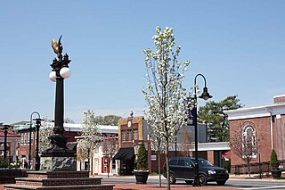
Middletown is a town in New Castle County, Delaware, United States. According to the 2021 Census, the population of the town is 24,164.

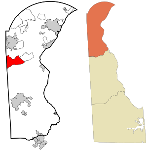
North Star is a census-designated place (CDP) in New Castle County, Delaware, United States. The population was 7,980 at the 2010 census.

<span class="mw-page-title-main">Odessa, Delaware</span> Town in Delaware, United States

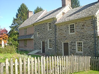
Odessa is a town in New Castle County, Delaware, United States. The population was 364 at the 2010 census. Founded as Cantwell's Bridge in the 18th century, the name was changed in the 19th century, after the Ukrainian port city of the same name. Today a significant part of the town is a historic district list on the National Register of Historic Places.

<span class="mw-page-title-main">Pike Creek, Delaware</span> CDP in Delaware, United States

Pike Creek is a census-designated place (CDP) in New Castle County, Delaware, United States and is part of the Philadelphia-Camden-Wilmington, PA-NJ-DE-MD Metropolitan statistical area. In 2007, CNN's Money Magazine ranked Pike Creek number 79 on its list of the 100 Best Places to Live in the United States. Pike Creek was the only community in Delaware to appear on the list. The population was 7,808 at the 2020 Census. Local attractions include Middle Run Natural Area, White Clay Creek State Park, Carousel Farm Park and Equestrian Center, Golf and Restaurants. Pike Creek is approximately five miles from downtown Newark, which contains the University of Delaware. Pike Creek is connected to the University of Delaware campus and the Newark downtown area by several bike trails. Pike Creek is approximately 10 miles west of the state's largest city, Wilmington, which is a national financial center.

<span class="mw-page-title-main">Wilmington Manor, Delaware</span> CDP in Delaware, United States

Wilmington Manor is a census-designated place (CDP) in north-eastern New Castle County, Delaware, United States. The population was 7,889 at the 2010 census.

<span class="mw-page-title-main">Rising Sun-Lebanon, Delaware</span> CDP in Delaware, United States

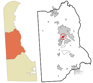
Rising Sun-Lebanon is a census-designated place (CDP) in Kent County, Delaware, United States. It is part of the Dover, Delaware Metropolitan Statistical Area. The population was 3,391 at the 2010 census.

<span class="mw-page-title-main">Nageezi, New Mexico</span> CDP in New Mexico, United States

Nageezi is a census-designated place (CDP) in San Juan County, New Mexico, United States. The population was 296 at the 2000 census. It is part of the Farmington Metropolitan Statistical Area. A post office was established in 1941. Nageezi's name in Navajo means "squash."

<span class="mw-page-title-main">Chesterbrook, Pennsylvania</span> Census-designated place in Pennsylvania, United States

Chesterbrook is a census-designated place (CDP) in Chester County, Pennsylvania, United States. It is located within the Philadelphia metropolitan area and just south of Valley Forge National Historical Park. The population was 4,589 at the 2010 census.

<span class="mw-page-title-main">Boothwyn, Pennsylvania</span> Census-designated place in Pennsylvania, United States

Boothwyn is a census-designated place (CDP) in Delaware County, Pennsylvania, United States. The population was 4,933 at the 2010 census, down from 5,206 at the 2000 census. The census estimation for population circa 2019 is 6,115.

<span class="mw-page-title-main">Broomall, Pennsylvania</span> Census-designated place in Pennsylvania, United States

Broomall is a census-designated place (CDP) in Marple Township, Delaware County, Pennsylvania, United States. The population was 10,789 at the 2010 census.

<span class="mw-page-title-main">Folsom, Pennsylvania</span> Census-designated place in Pennsylvania, United States

Folsom is a census-designated place (CDP) in Delaware County, Pennsylvania, United States. It is part of Ridley Township. The population was 8,323 at the 2010 census.

<span class="mw-page-title-main">Village Green-Green Ridge, Pennsylvania</span> Census-designated place in Pennsylvania, United States

Village Green-Green Ridge is a census-designated place (CDP) in Delaware County, Pennsylvania, United States. The population was 7,822 at the 2010 census, down from 8,279 at the 2000 census.

References

  1. "2020 U.S. Gazetteer Files". United States Census Bureau. Retrieved October 31, 2021.
  2. "Glasgow". Geographic Names Information System . United States Geological Survey, United States Department of the Interior.
  3. "National Register Information System". National Register of Historic Places . National Park Service. July 9, 2010.
  4. "US Gazetteer files: 2010, 2000, and 1990". United States Census Bureau. February 12, 2011. Retrieved April 23, 2011.
  5. "CENSUS OF POPULATION AND HOUSING (1790-2000)". U.S. Census Bureau . Retrieved May 20, 2012.
  6. "U.S. Census website". United States Census Bureau . Retrieved January 31, 2008.
  7. "2020 CENSUS - SCHOOL DISTRICT REFERENCE MAP: New Castle County, DE" (PDF). U.S. Census Bureau . Retrieved June 18, 2021.
  8. "Suburban Elementary Schools" (PDF). Christina School District. December 29, 2009. Archived from the original (PDF) on December 29, 2009. Retrieved June 24, 2021.
  9. "Suburban Middle Schools" (PDF). Christina School District. December 29, 2009. Archived from the original (PDF) on December 29, 2009. Retrieved June 24, 2021.
    Older map: "Christina School District Suburban Feeder Pattern, Grades 7-8". Christina School District. November 21, 2002. Archived from the original on November 21, 2002. Retrieved June 22, 2021.
  10. "Christina School District Suburban Feeder Pattern, Grades 9-12". Christina School District. November 21, 2002. Archived from the original on November 21, 2002. Retrieved June 22, 2021.
  11. "Appoquinimink School District". www.apposchooldistrict.com. Retrieved September 12, 2023.