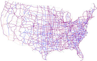
The United States Numbered Highway System is an integrated network of roads and highways numbered within a nationwide grid in the contiguous United States. As the designation and numbering of these highways were coordinated among the states, they are sometimes called Federal Highways, but the roadways were built and have always been maintained by state or local governments since their initial designation in 1926.

Carmarthenshire is a county in the south-west of Wales. The three largest towns are Llanelli, Carmarthen and Ammanford. Carmarthen is the county town and administrative centre. The county is known as the "Garden of Wales" and is also home to the National Botanic Garden of Wales.

Llanelli is a market town and community in Carmarthenshire and the preserved county of Dyfed, Wales. It is located on the Loughor estuary and is the largest town in the county of Carmarthenshire. The town is 11 miles (18 km) north-west of Swansea and 12 miles (19 km) south-east of Carmarthen. The town had a population of 25,168 in 2011, estimated in 2019 at 26,225. The local authority was Llanelli Borough Council when the county of Dyfed existed, but it has been under Carmarthenshire County Council since 1996.

Burry Port is a port town and community in Carmarthenshire, Wales, on the Loughor estuary, to the west of Llanelli and south-east of Kidwelly. Its population was recorded at 5,680 in the 2001 census and 6,156 in the 2011 census, and estimated at 5,998 in 2019. The town has a harbour. It is also where Amelia Earhart landed as the first woman to fly across the Atlantic Ocean. Nearby are the Pembrey Burrows sand dune and wetland system, forming a country park, and the Cefn Sidan sands. Its musical heritage includes Burry Port Opera, Male Choir and Burry Port Town Band.

Kidwelly is a town and community in Carmarthenshire, southwest Wales, approximately 7 miles (11 km) northwest of the most populous town in the county, Llanelli. In the 2001 census the community of Kidwelly returned a population of 3,289, increasing to 3,523 at the 2011 Census.
Pembrey Burrows stretch from Burry Port's harbour area – a former coal port, now a marina – to Pembrey Country Park, a leisure and nature complex that is one of West Wales's leading visitor attraction.

Pembrey Sands Air Weapons Range is a Ministry of Defence air weapons range located near the village of Pembrey, Carmarthenshire, 3 miles (4.8 km) northwest of Burry Port and 10.3 miles (16.6 km) south of Carmarthen, Wales. Adjacent to the weapons range site is a former Royal Air Force station known as Royal Air Force Pembrey, or more simply RAF Pembrey, which closed in 1957 and of which part is now in civilian use as Pembrey Airport.

No. 10 Group RAF was a former operations group of the Royal Air Force which participated in the Second World War.

Pembrey is a village in Carmarthenshire, Wales, situated between Burry Port and Kidwelly, overlooking Carmarthen Bay, with a population of about 2,154 in 2011. The electoral ward having a population of 4,301. It is in the community of Pembrey and Burry Port Town.

Pembrey West Wales Airport is located 6 NM west northwest of Llanelli in Pembrey, Carmarthenshire, in Wales. Pembrey has one hard runway designated as 22LH/C and 04RH/C. The airport and its ICAO code EGPF were withdrawn from the Aeronautical Information Publication in July 2022.

Llanelli is a constituency of the House of Commons of the Parliament of the United Kingdom. From 1918 to 1970 the official spelling of the constituency name was Llanelly. It elects one Member of Parliament (MP) by the first past the post system of election. Since 2005, it is currently represented by Nia Griffith of the Labour Party.

Pembrey and Burry Port railway station is a railway station on the West Wales line serving Pembrey and Burry Port, in Carmarthenshire, Wales. It is adjacent to Burry Port's main shopping area. Pembrey is situated 1.2 miles (2 km) to the west. The station is 229 miles 15 chains (368.8 km) from the zero point at London Paddington, measured via Stroud.

Pembrey Circuit is a motor racing circuit near Pembrey village, Carmarthenshire, Wales. It is the home of Welsh motorsport, providing racing for cars, motorcycles, karts and trucks. The circuit's facilities have also been used for a single-venue rally.

Motorsport is a popular sport in the United Kingdom. The United Kingdom is a key player in the world of motorsport, hosting rounds of the Formula One World Championship, World Rally Championship and Grand Prix motorcycle racing, amongst others. It is also the home of many of the current teams in Formula One, such as McLaren, Williams and Aston Martin, while teams such as Red Bull Racing, Mercedes, Alpine and Haas are also based in England. There are also a range of popular national series held such as the British Touring Car Championship. The Motor Sports Association is the official governing body of motorsport in the United Kingdom.

The Kidwelly and Llanelly Canal was a canal and tramroad system in Carmarthenshire, Wales, built to carry anthracite coal to the coast for onward transportation by coastal ships. It began life as Kymer's Canal in 1766, which linked pits at Pwll y Llygod to a dock near Kidwelly. Access to the dock gradually became more difficult as the estuary silted up, and an extension to Llanelli was authorised in 1812. Progress was slow, and the new canal was linked to a harbour at Pembrey built by Thomas Gaunt in the 1820s, until the company's own harbour at Burry Port was completed in 1832. Tramways served a number of collieries to the east of Burry Port.
Pembrey and Burry Port Town is a community located in Carmarthenshire, Wales including the town of Burry Port and the village of Pembrey. The community population taken at the 2011 census was 8,547.

Court Farm in Pembrey, Carmarthenshire, Wales, is an ancient and formerly imposing manor house which is now an overgrown ruin, but structurally sound, and capable of repair and restoration. It consists of three buildings: the farmhouse, a complex two-storey house of approximately 99 square metres; an adjacent barn; and a later cowshed.
This is list of locations in the United States named after places in Wales. A number of places in the U.S have been named after places in Wales by Welsh settlers and explorers. and are mainly in the 13 eastern states which used to be the Thirteen Colonies in the British Empire. A number of US towns such as Newport and Newtown maybe named after the similarly names Welsh towns or may have been named solely because of their location. Only those places where there is an evidential link with Wales are included here.
Pembrey railway station or Pembrey Halt railway station served the village of Pen-bre or Pembrey. It continued to serve the inhabitants of the area between 1909 and 1953 and was one of several basic halts opened on the Burry Port and Gwendraeth Valley Railway in Carmarthenshire, Wales.


