
Delaware is a state in the Mid-Atlantic region of the United States, bordering Maryland to its south and west, Pennsylvania to its north, New Jersey to its northeast, and the Atlantic Ocean to its east. The state takes its name from the adjacent Delaware Bay, in turn named after Thomas West, 3rd Baron De La Warr, an English nobleman and Virginia's first colonial governor.

The Mason–Dixon line, also called the Mason and Dixon line or Mason's and Dixon's line, is a demarcation line separating four U.S. states, forming part of the borders of Pennsylvania, Maryland, Delaware, and West Virginia. It was surveyed between 1763 and 1767 by Charles Mason and Jeremiah Dixon as part of the resolution of a border dispute involving Maryland, Pennsylvania, and Delaware in the colonial United States. The dispute had its origins almost a century earlier in the somewhat confusing proprietary grants by King Charles I to Lord Baltimore (Maryland), and by his son King Charles II to William Penn.
Hanover County is a county in the Commonwealth of Virginia. As of the 2020 census, the population was 109,979. Its county seat is Hanover Courthouse.
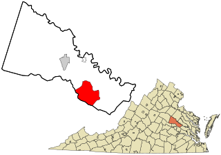
Mechanicsville is an unincorporated area and census-designated place (CDP) in Hanover County, Virginia, United States. The population was 39,482 during the 2020 census, up from 36,348 in the 2010 census.
Mechanicsville is the name of several localities in North America.
Mechanicsville is an unincorporated community and census-designated place (CDP) in the southern part of the town of Thompson in Windham County, Connecticut, United States. It is bordered to the north by North Grosvenor Dale and to the south by Putnam. Connecticut Route 12 runs the length of the community, along the east side of the French River.

Delaware Bay is the estuary outlet of the Delaware River on the northeast seaboard of the United States, lying between the states of Delaware and New Jersey. It is approximately 782 square miles (2,030 km2) in area, the bay's freshwater mixes for many miles with the saltwater of the Atlantic Ocean.

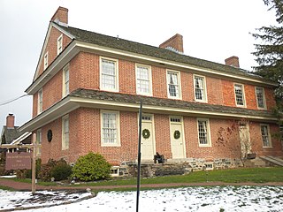
The Wedge is a 1.068-square-mile tract of land along the borders of Delaware, Maryland and Pennsylvania. Ownership of the land was disputed until 1921; it is now recognized as part of Delaware. The tract was created primarily by the shortcomings of contemporary surveying techniques when the boundaries were defined in the 18th century. It is bounded on the north by an eastern extension of the east–west portion of the Mason–Dixon line, on the west by the north–south portion of the Mason–Dixon line, and on the southeast by the Twelve-Mile Circle around New Castle, Delaware. The crossroads community of Mechanicsville, Delaware, lies within the area today.
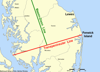
The Transpeninsular Line is a surveyed line, the eastern half of which forms the north–south border between Delaware and Maryland. The border turns roughly north from the midpoint of the line towards the Twelve-Mile Circle, which forms much of the remainder of the Delaware land border.

The Twelve-Mile Circle is an approximately circular arc that forms most of the boundary between Delaware and Pennsylvania. It is a combination of different circular arcs that have been feathered together.

Mechanicsville is an unincorporated community and census-designated place in St. Mary's County, Maryland, United States. It is adjacent to the community of Charlotte Hall, which is known for its agriculture, Amish population, large farmers' market/flea market and the Maryland Veterans Home. Mechanicsville has many small businesses and restaurants along Maryland Route 5 and Maryland Route 235. The community is served by the St. Mary's County Public Schools, including Chopticon High School. At the 2010 census, Mechanicsville had a population of 1,528.
A wedge is a triangular-shaped simple machine.
Mechanicsville is a neighborhood in Knoxville, Tennessee, United States, located northwest of the city's downtown area. One of the city's oldest neighborhoods, Mechanicsville was established in the late 1860s for skilled laborers working in the many factories that sprang up along Knoxville's periphery. The neighborhood still contains a significant number of late-19th-century Victorian homes, and a notable concentration of early-20th-century shotgun houses. In 1980, several dozen properties in Mechanicsville were added to the National Register of Historic Places as the Mechanicsville Historic District. The neighborhood was also designated as a local historic district in 1991, subject to historic zoning and design standards.
Border irregularities of the United States, particularly panhandles and highway incursions into other jurisdictions, are shown here. Often they are a result of borders which do not conform to geological features such as changes in the course of a river that previously marked a border.
New Jersey v. Delaware, 552 U.S. 597 (2008), is a United States Supreme Court case in which New Jersey sued Delaware, invoking the Supreme Court's original jurisdiction under 28 U.S.C. § 1251(a), following Delaware's denial of oil company BP's petition to build a liquefied natural gas pipeline and loading facility on the New Jersey side of the Delaware River. Delaware denied BP's petition because it violated Delaware's Coastal Zone Act. BP then sought New Jersey's approval of the project. Delaware objected because the construction would require dredging of underwater land within Delaware's borders, which extend to the low-tide mark of the New Jersey shore. BP's proposal had not yet passed New Jersey's approval process when New Jersey and BP filed suit against Delaware.
Guyencourt is an unincorporated community in New Castle County, Delaware, United States. Guyencourt is located at the intersection of Delaware Route 100 and Guyencourt Road, north of Wilmington and south of the Pennsylvania border.
Mechanicsville is an unincorporated community in Buckingham Township in Bucks County, Pennsylvania, United States. Mechanicsville is located at the intersection of Pennsylvania Route 413 and Mechanicsville Road.
Paunnacussing Creek is a tributary of the Delaware River contained wholly within Bucks County, Pennsylvania in the United States. It rises from a pond north of Mechanicsville, in Buckingham Township and drains into the Delaware at Bull Island just upstream of Lumberville in Solebury Township.
The Atlanta Voice is an African-American community newspaper serving the greater Atlanta metropolitan area. The paper is published weekly on Fridays.
Dilworthtown is an unincorporated community and census-designated place (CDP) in Chester and Delaware counties, Pennsylvania, United States. It was first listed as a CDP prior to the 2020 census.


