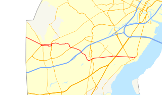
Delaware Route 273 (DE 273) is a state highway in New Castle County, Delaware. The route runs from Maryland Route 273 (MD 273) at the Maryland border near Newark east to DE 9 and DE 141 in New Castle. The route runs through suburban areas between Newark and New Castle as a multilane road, passing through Ogletown and Christiana. DE 273 intersects DE 896 in downtown Newark; DE 2/DE 72 on the eastern edge of Newark; DE 4 in Ogletown; Interstate 95 (I-95), DE 7, and DE 1 in Christiana; DE 37 in Pleasantville; and DE 58 and U.S. Route 13 (US 13)/US 40 in Hares Corner.
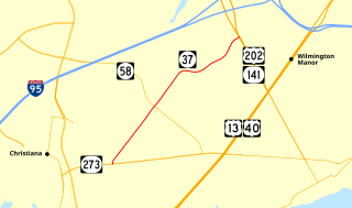
Delaware Route 37 (DE 37) is a state highway in New Castle County, Delaware. The route runs from DE 273 in Pleasantville northeast to U.S. Route 202 (US 202) and DE 141 near the Wilmington Airport. The road runs through suburban neighborhoods before passing along the edge of Wilmington Airport, where it provides access to a business park. The Airport Road portion of DE 37 was originally a dirt road that was paved by 1942. DE 37 was assigned to its current alignment by 1985.
Talleyville is an unincorporated community in New Castle County, Delaware, United States. Talleyville is located at the intersection of U.S. Route 202, Mt. Lebanon Road, and Silverside Road to the north of Wilmington. Its ZIP code is 19803.
Granogue is an unincorporated community in New Castle County, Delaware, United States. Granogue is located along Smiths Bridge Road west of the Brandywine Creek and south of the Pennsylvania border.
Ways Corner is an unincorporated community in New Castle County, Delaware, United States. Ways Corner is located at the intersection of Delaware routes 92 and 261, northeast of Wilmington.
Talleys Corner is an unincorporated community in New Castle County, Delaware, United States. Talleys Corner is located at the intersection of Delaware Route 261 and Silverside Road, northeast of Wilmington and east of Talleyville.
Guyencourt is an unincorporated community in New Castle County, Delaware, United States. Guyencourt is located at the intersection of Delaware Route 100 and Guyencourt Road north of Wilmington and south of the Pennsylvania border.
Boyds Corner is an unincorporated community in New Castle County, Delaware, United States. Boyds Corner is located at the intersection of U.S. Route 13 and Delaware Route 896 north of Odessa.
Mathews Corners is an unincorporated community in New Castle County, Delaware, United States. Mathews Corners is located on Delaware Route 299, just west of Delaware Route 9, to the southeast of Odessa.
Wrangle Hill is an unincorporated community in New Castle County, Delaware, United States. Wrangle Hill is located at the intersection of U.S. Route 13, Delaware Route 7, and Delaware Route 72 west of Delaware City. The community was named after a feud between two early families.

Red Lion is an unincorporated community in New Castle County, Delaware, United States. Red Lion is located at the intersection of Delaware Route 7 and Delaware Route 71, northwest of Delaware City and southwest of New Castle. The community takes its name from a colonial tavern. and lends it name to the Red Lion Hundred.

State Road is an unincorporated community in New Castle County, Delaware, United States. State Road is located at the intersection of U.S. Route 13 and U.S. Route 40, southwest of New Castle.

Prices Corner is an unincorporated community in New Castle County, Delaware, United States. Prices Corner is located at the intersection of Delaware Route 2 and Delaware Route 141, west of Wilmington. The Prices Corner Shopping Center is located in Prices Corner.
Taylors Bridge is an unincorporated community in Appoquinimink Hundred and Blackbird Hundred, New Castle County, Delaware, United States. Taylors Bridge is located on Delaware Route 9, 7.4 miles (11.9 km) east-southeast of Middletown. It is named for the bridge that carries Route 9 over the Blackbird Creek, the boundary between the two hundreds.
Collins Beach is an unincorporated community in New Castle County, Delaware, United States. Collins Beach is located along the Delaware Bay at the east end of Collins Beach Road northeast of Smyrna.
Augustine Beach is an unincorporated community in New Castle County, Delaware, United States. Augustine Beach is located on the west bank of the Delaware River along Delaware Route 9 northeast of Odessa.
Milford Crossroads is an unincorporated community in New Castle County, Delaware, United States. Milford Crossroads is located along Delaware Route 72, at the intersection of Possum Park Road/Thompson Station Road and Paper Mill Road, northeast of Newark.
Silview is an unincorporated community in New Castle County, Delaware, United States. Silview is located along Delaware Route 4, west of Newport.
Fieldsboro is an unincorporated community in New Castle County, Delaware, United States. Fieldsboro is located at the intersection of U.S. Route 13 and Fieldsboro Road south of Odessa.
Milltown is an unincorporated community in New Castle County, Delaware, United States. Milltown is located at the intersection of Delaware Route 7 and Milltown Road west of Wilmington.


