I-35W & 46th Street station

Last updated

I-35W & 46th St
Side view of north entrance to I-35W & 46th Street Station.jpg
I-35W & 46th St station as seen from the 46th St overpass
General information
Location175/180 East 46th Street
Minneapolis, Minnesota
Coordinates 44°55′11″N93°16′29″W / 44.919674°N 93.274784°W / 44.919674; -93.274784
Platforms1 island platform
ConnectionsAiga bus trans.svg Metro Transit: 11, 46
Construction
AccessibleYes
History
OpenedDecember 4, 2010 (2010-12-04) [1]
Services
Preceding station Metro Minnesota icon.svg Metro Following station
I-35W & Lake Street Orange Line I-35W & 66th Street

I-35W & 46th Street station is a Metro Orange Line bus rapid transit station located in Minneapolis, Minnesota. In addition to the BRT service, the station is also served by Metro route 578. The station was constructed as part of the I-35W/Minnesota State Highway 62 Crosstown Commons reconstruction project and opened in 2010. [2] Consisting of two levels, one on East 46th Street, and the other in the median of Interstate 35W, the station was the first of its kind in Minnesota. The station allows for transit routes operating on I-35W to stop for riders without leaving the region's high occupancy toll lane system. The station was designed in anticipation of full bus rapid transit service along I-35W to downtown Minneapolis, a vision that was realized in 2021 with the opening of the Metro Orange Line. The station cost $4.5 million to build. [3]

Contents

Background and history

While making plans to restructure transit service in the south metro areas in 2002, Metro Transit planners proposed constructing transit stations at locations along I-35W at Diamond Lake Road, 46th Street, and 35th/36th Streets. Stations along I-35W were not planned to accommodate park-and-ride facilities. At the time there was no crosstown service on 46th Street. [4] The approved plan created Route 46 which travels between Edina and Saint Paul along 46th Street among other streets. A new route that was eventually replaced by the Orange Line, Route 535, was also instituted to provide all-day express transit service between Bloomington, Richfield, and downtown Minneapolis. [5]

The Minnesota Legislature passed a bill to study BRT in the I-35W corridor from Lakeville to Minneapolis in 2003 with bipartisan support from Lakeville and Minneapolis legislators. [6] Plans for the station were included in the Crosstown Commons reconstruction project. The Minnesota Department of Transportation was required to request municipal consent from the city of Minneapolis for project but were initially denied consent in 2004 due to the city's concern that MnDOT was not sufficiently committed to BRT on I-35W. [7] MnDOT appealed to a board created under state law. The appeals board created a plan to create the 46th St Station and have MnDOT commit to funding transit projects. [8] Minneapolis eventually approved municipal consent in April 2005 after it reach an agreement with MnDOT to extend BRT north from the Crosstown Commons project border to downtown. Extending BRT to downtown would involve the then unfunded I-35W Access Project. Unresolved issues included how buses would travel from the HOT lanes in the center to bus only shoulder lanes after 46th Street and into downtown. Transit stops and a potential BRT station at Lake Street were other concerns. [9]

Plans for the 46th Street Station in 2004 were compared to the Uptown Transit Center minus the parking and turnaround space for buses which was a smaller proposal than a bus hub proposed in 2000. There was no funding identified for the 46th Street Station in 2004. [10] By 2006 the state legislature approved $3.3 million in the bonding bill for design and construction of the station. Construction of the station was predicated on the replacement of the 46th Street bridge over I-35W and phasing of the Crosstown Commons reconstruction but was expected to open in 2010 or 2011. [11] Federal funding was also identified when the region applied through the Urban Partnership Agreement which identified ways to reduce congestion, especially along the I-35W corridor. [12]

Opening

When the station opened in December 2010, transit service in the area was restructured to allow for transfers between I-35W buses and crosstown routes, improve travel times to suburban locations, and the introduction of full BRT service along the I-35W corridor. Thirteen routes were impacted. [13] [14] Transit service on crosstown Route 46 had its frequency increased from every 30 minutes to every 15 minutes. [3] Local neighbors were concerned about people "park-and-hiding" where riders park in local streets and walk to the station. [15] [16] Upon opening, the portion of the station serving I-35W was open five days a week with transit service on the 46th Street portion of the station available all week. [17] An estimated 330 people were expected to begin using the station on weekdays with up to 550 on weekdays once full BRT service was implemented with an expected opening in 2012. [3]

Full BRT service was finally implemented in 2021 with the opening of the Metro Orange Line . Local and express transit service in the area was again restructured to coincide with the opening of the Orange Line. Two bus routes were eliminated, Routes 535 and 597, and replaced by the Orange Line. The Orange Line offers service to the station on seven days a week. [18]

Station

A METRO Orange Line bus boards passengers heading northbound on the freeway level of station Freeway level platform for I-35W and 46th Street Station.jpg
A METRO Orange Line bus boards passengers heading northbound on the freeway level of station

The station uses a single center platform for passenger pick-up and drop-off. Buses on the route use the standard right-hand traffic configuration with entrance/exit doors on the right, so the northbound and southbound busways cross over each other immediately north and south of the station so that the doors will face the platform. Bus traffic is controlled via gates and traffic signals through the cross over portion of the travel lanes so that buses do not collide with each other. Northbound riders board and disembark on the west side of the platform while southbound riders do so on the east side of the platform. The station has real-time transit information and indoor waiting areas. [17] Geothermal heating and cooling is provided by 24 geothermal wells. [16]

The station is compliant with the Americans with Disabilities Act and has a pair stairway and elevator towers, one on each side of the 46th Street bridge. [17] The interior of the station can hold around 100 people and the platforms outside around 180. [15]

Related Research Articles

In public transit, particularly bus, tram, or train transportation, a limited-stop service is a trip pattern that stops less frequently than a local service. Many limited-stop or semi-fast services are a combination of commuter rail and express train.

Metro Transit is the primary public transportation operator in the Minneapolis–Saint Paul area of the U.S. state of Minnesota and the largest operator in the state. Although Metro Transit is one of the smallest transit systems for a large metropolitan area in the United States, it has previously been ranked as one of the best. In 2023, the system had a ridership of 44,977,200, or about 145,600 per weekday as of the fourth quarter of 2023.

<span class="mw-page-title-main">Calgary Transit</span> Public transit service in Calgary, Alberta

Calgary Transit is the public transit agency which is owned and operated by the city of Calgary, Alberta, Canada. In 2019, an estimated 106.5 million passengers boarded approximately 1,155 Calgary Transit vehicles. It operates light metro (LRT), urban tramway, bus rapid transit (BRT), para-transit, and regular bus services. In 2023, the system had a ridership of 144,385,200, or about 463,000 per weekday as of the fourth quarter of 2023.

<span class="mw-page-title-main">Lake Street/Midtown station</span> Light rail station in Minneapolis, Minnesota

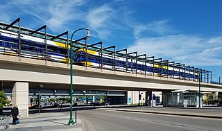
Lake Street/Midtown station, also referred locally as either the Lake Street station or Midtown station, is a Blue Line light rail stop in Minneapolis, Minnesota, United States. The station is located on an bridge over East Lake Street adjacent to Highway 55.

<span class="mw-page-title-main">Lake Street (Minneapolis)</span>

Lake Street is a major east-west thoroughfare between 29th and 31st streets in Minneapolis, Minnesota United States. From its western most end at the city's limits, Lake Street reaches the Chain of Lakes, passing over a small channel linking Bde Maka Ska and Lake of the Isles, and at its eastern most end it reaches the Mississippi River. In May 2020, the Lake Street corridor suffered extensive damage during local unrest following the murder of George Floyd. In August of the same year, city officials designated East Lake Street as one of seven cultural districts to promote racial equity, preserve cultural identity, and promote economic growth.

<span class="mw-page-title-main">Interstate 35W (Minnesota)</span> Interstate Highway in Minnesota, United States

Interstate 35W (I-35W) is an Interstate Highway in the US state of Minnesota, passing through downtown Minneapolis. It is one of two through routes for I-35 through the Twin Cities of Minneapolis and Saint Paul, the other being I-35E through downtown Saint Paul.

<span class="mw-page-title-main">Minnesota Valley Transit Authority</span> Public transportation agency in Minnesota, US

The Minnesota Valley Transit Authority, also known by the acronym MVTA, is a public transportation agency that serves seven communities in the southern portion of the Minneapolis–Saint Paul metropolitan area. The agency provides fixed-route and demand-responsive transit within the service area of the communities and to select destinations in the region.

<span class="mw-page-title-main">Burnsville Transit Station</span> Transit facility in Burnsville, Minnesota

Burnsville Transit Station is a transit facility located in the vicinity of downtown Burnsville, Minnesota, and is the flagship station of the Minnesota Valley Transit Authority (MVTA). The station is the busiest park and ride location in the Twin Cities region and offers approximately 1,400 parking spaces. It is also a major transfer hub for routes operating the south of the Minnesota River. The station has indoor climate-controlled waiting, restrooms, lost and found, drinking fountains, vending machines, Go-To card sales, newspaper racks, and transit information. Due to high park and ride demand, MVTA moved some service to the 370 space Heart of the City public ramp about a 12 mile (0.80 km) south in 2018. The Metropolitan Council's 2021 park-and-ride system report found 267 cars parked at the station compared to 1,116 in 2019 before the COVID-19 pandemic.

<span class="mw-page-title-main">Metro Orange Line (Minnesota)</span> Minnesota bus line

The Metro Orange Line is a bus rapid transit line in the Twin Cities, Minnesota operated by Metro Transit. The line operates primarily along Interstate 35W from downtown Minneapolis through Richfield and Bloomington before terminating in Burnsville, Minnesota. The Orange Line provides access to 198,000 jobs with roughly a quarter of them outside downtown Minneapolis. The route serves a mix of stations located in the center of the highway, stations near highway exits, and on-street stations. The line has features typical of bus rapid transit systems with off-board fare payment, articulated buses with extra doors, stations with improved passenger amenities, and transit-only bus lanes on portions of the route.

<span class="mw-page-title-main">Kenrick Avenue Park and Ride station</span> Parking facility in Lakeville, Minnesota

The Kenrick Avenue Park and Ride is a 750-space parking ramp in Lakeville, Minnesota providing interchange for bus passengers.

<span class="mw-page-title-main">I-35W & Lake Street station</span> Bus rapid transit station in Minneapolis

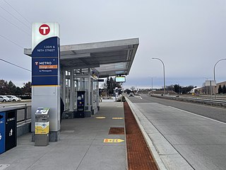
I-35W & Lake Street station is a bus rapid transit station along the Metro Orange Line and planned B Line bus rapid transit (BRT) routes in Minneapolis, Minnesota. In addition to the BRT services, the station is also served by Metro route 578, Minnesota Valley Transit Authority routes 460, 465, 467, 470, 472, 475 and 477, along with SouthWest Transit routes 600 and 695.

<span class="mw-page-title-main">I-35W & 98th Street station</span> Bus station in Bloomington, Minnesota

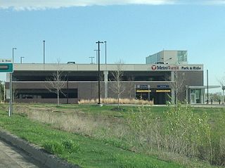
I-35W & 98th Street is a bus rapid transit station on the Metro Orange Line at 98th Street adjacent to Interstate 35W in Bloomington, Minnesota. The station is integrated with the South Bloomington Transit Center, a transfer hub and park and ride facility opened in 2004. The transit center was as far south as Route 535, predecessor to the Orange Line, traveled, with no direct connection to the other side of the Minnesota River. The station opened December 4, 2021 with the rest of the Orange Line.

The Urban Partnership Agreement (UPA) is an effort of the United States Department of Transportation and agencies in four metropolitan areas across the country which are testing out several technologies as an effort to reduce congestion in urban areas. The metro areas of Miami, Florida, Minneapolis, Minnesota, San Francisco, California, and Seattle, Washington are participants. The technologies being used include bus rapid transit (BRT), high-occupancy toll lane (HOT) lanes and other congestion pricing, dynamic message signs, and other lane management signage.

<span class="mw-page-title-main">Metro (Minnesota)</span> Rapid transit network in the Minneapolis metropolitan area of the United States

Metro is a transit network in Minnesota serving the cities of Minneapolis and Saint Paul. It also provides service to some suburban areas. As of 2022, the system consists of two light rail lines and five bus rapid transit (BRT) lines all of which are operated by the local public transit company: Metro Transit. The five lines connect Downtown Minneapolis and St Paul with the Bloomington, Minneapolis-St Paul International Airport, Roseville, Richfield, Burnsville and Brooklyn Center.

<span class="mw-page-title-main">Metro A Line (Minnesota)</span> Bus rapid transit line in the Minneapolis metropolitan area of the United States

The Metro A Line is a bus rapid transit line in the Twin Cities, Minnesota operated by Metro Transit. The A Line operates primarily along the Snelling Avenue corridor and travels through the cities of Minneapolis, Saint Paul, Falcon Heights, and Roseville. From the Blue Line in Minneapolis, the line travels past Minnehaha Park, through the Highland Village commercial area, past Macalester College, and connects to the Green Line near Allianz Field. The line continues through Saint Paul, past Hamline University, before traveling through Falcon Heights and Roseville, where the line passes the Minnesota State Fairgrounds, Har Mar Mall, and terminates at Rosedale Center.

<span class="mw-page-title-main">Metro C Line (Minnesota)</span> Bus rapid transit line in the Minneapolis metropolitan area of the United States

The Metro C Line is a bus rapid transit line in Brooklyn Center and Minneapolis, Minnesota operated by Metro Transit. The line is part of Metro Transit's Metro network of light rail and bus rapid transit lines. The route operates from the Brooklyn Center Transit Center along Penn Avenue and Olson Memorial Highway, terminating in downtown Minneapolis. The route is analogous to the existing Route 19 and is projected to increase ridership on this corridor from 7,000 to 9,000 by 2030. Eventually, part of its route will shift south to Glenwood Avenue from Olson Memorial Highway.

<span class="mw-page-title-main">Metro D Line (Minnesota)</span> Bus rapid transit line in the Minneapolis metropolitan area of the United States

The Metro D Line is a bus rapid transit line in Minneapolis-Saint Paul, Minnesota. The 18.5-mile (29.8 km) route primarily operates on Fremont and Chicago Avenues from Brooklyn Center through Minneapolis to the Mall of America in Bloomington. As part of BRT service, the D Line features "train-like amenities" including improved station facilities, off-board fare payment, modern vehicles, fewer stops, and higher frequency. The current alignment would substantially replace the existing Route 5, the highest ridership bus route in Minnesota.

<span class="mw-page-title-main">Metro B Line (Minnesota)</span> Planned bus rapid transit line in the Minneapolis metropolitan area of the United States

The Metro B Line is an under construction bus rapid transit route in Minneapolis and St. Paul. The route will operate mostly on Lake Street in Minneapolis before crossing the Mississippi River into St. Paul and operating mostly on Selby Avenue and ending in downtown St. Paul. The route was identified in Metro Transit's 2014 Arterial Transitway Corridors Study as one of eleven local routes to be upgraded to bus rapid transit. The route will have "train-like" features to speed up service, such as signal priority, all-door boarding, further stop spacing, and specialized vehicles. Planning and design was completed in 2021, with construction beginning in May 2023. The line will join a number of Metro Transit's future Metro system lines, as well as the currently operating A Line, C Line, and D Line. Full funding for the line was secured in October 2020 with a final $35 million from the state of Minnesota.

<span class="mw-page-title-main">Marq2 transit corridor</span> Public transit corridor through Minneapolis, Minnesota

The Marq2 transit corridor is a north–south thoroughfare in Minneapolis, Minnesota, United States. It consists of the parallel streets of Marquette and Second avenues in the downtown area. Each public streetway has two contraflow bus lanes with two lanes available for general-purpose traffic in the opposite direction. Vehicular transit flows south on Marquette Avenue and north on Second Avenue. The inner curb lane allows buses to stop for riders, while the second bus-only lane allows buses to pass each other along the corridor. Bus routes that operate on the corridor stop at every other block at an assigned gate with each route assigned a northbound and southbound gate. Gates are assigned letters A, B, C, or D on Marquette Avenue and E, F, G, and H on Second Avenue. Custom bus shelters are installed at each stop with heaters and real time transit information. The corridor primarily serves express buses operated by all five public transit agencies in the Twin Cities.

References

  1. "Timeline". Metro Transit. Archived from the original on August 7, 2011. Retrieved July 8, 2022.
  2. "I-35W/Hwy 62 Crosstown reconstruction project". Mn/DOT. Archived from the original on March 18, 2012. Retrieved March 21, 2012.
  3. 1 2 3 Geiger, Bob (December 7, 2010). "So far, riders give thumbs-up for 46th Street facility | Finance & Commerce". Finance & Commerce. Archived from the original on September 21, 2020. Retrieved July 7, 2022.
  4. Repya, Robyn (November 18, 2002). "New plan would change Southwest bus service". Southwest Journal. Archived from the original on July 8, 2022. Retrieved July 7, 2022.
  5. Repya, Robyn (June 28, 2007). "New Southwest bus plan for '04 approved". Southwest Journal. Archived from the original on July 8, 2022. Retrieved July 7, 2022. [Wrong date]
  6. Repya, Robyn (November 25, 2004). "Bipartisan bridge-building boosts I-35W transit". Southwest Journal . Archived from the original on July 8, 2022. Retrieved July 7, 2022.
  7. Repya, Robyn; Brauer, David (September 16, 2004). "City Council denies Crosstown expansion consent". Southwest Journal . Archived from the original on July 8, 2022. Retrieved July 7, 2022.
  8. Cavanaugh, Patricia (October 2006). "Politics and Freeways: Building the Twin Cities Interstate System" (PDF). University of Minnesota – Center for Urban and Regional Affairs. Center for Transportation Studies. p. 83. Retrieved September 17, 2023.
  9. Repya, Robyn (April 4, 2005). "State-city Crosstown deal could boost transit, Access Project". Southwest Journal . Archived from the original on July 8, 2022. Retrieved July 7, 2022.
  10. Repya, Robyn (October 28, 2004). "State shows off I-35W bus rapid transit options". Southwest Journal. Archived from the original on July 8, 2022. Retrieved July 7, 2022.
  11. Haugen, Dan (January 15, 2007). "Proposed transit hub will be regional model". Southwest Journal. Archived from the original on July 8, 2022. Retrieved July 7, 2022.
  12. Vanderveen, Kari (July 2, 2007). "In the fast lane". Southwest Journal. Archived from the original on January 18, 2021. Retrieved July 7, 2022.
  13. "I-35W & 46th Street Transit Plan". Metro Transit. Archived from the original on November 17, 2011. Retrieved July 8, 2022.
  14. "Learn About Proposed Service Changes in I-35W and 46th Street Corridors – Fulton Neighborhood". Fulton Neighborhood Association. June 2, 2010. Archived from the original on July 8, 2022. Retrieved July 7, 2022.
  15. 1 2 "46th St. BRT Station". Kingfield Neighborhood Association. June 10, 2009. Archived from the original on July 8, 2022. Retrieved July 7, 2022.
  16. 1 2 Halter, Nick (December 13, 2010). "New station a big step for rapid bus service". Southwest Journal. Archived from the original on July 8, 2022. Retrieved July 7, 2022.
  17. 1 2 3 "I-35W & 46th Street Station". Metro Transit. Archived from the original on March 8, 2012. Retrieved March 21, 2012.
  18. Schuster, Christine (December 7, 2021). "Orange Line service launches between Burnsville and Minneapolis". SWNewsMedia.com. Archived from the original on July 8, 2022. Retrieved July 8, 2022.