
Chucuito District is one of the districts of the Puno Province in the Puno Region in Peru.
Putina District is one of five districts of the San Antonio de Putina Province in Peru.
Pedro Vilca Apaza District is one of five districts of the province San Antonio de Putina in Peru.

Inka Wasi is an archaeological site in the Huancavelica Region in Peru. The Inca palace is considered one of the most important monuments of the Huancavelica Region. Inka Wasi is located in the Huaytará Province, Huaytará District, about 25 km from Huaytará. It is situated at a height of 3,804 m (12,480 ft).
Willkawayin is an archaeological site in Peru. It is located in the Ancash Region, Huaraz Province, Independencia District, in the village of Paria. It is situated at a height of about 3,400 m (11,200 ft).
Mawk'allaqta, also Mawk'a Llaqta is an archaeological site in Peru. It is located in the Puno Region, Melgar Province, Nuñoa District. The site was declared a National Cultural Heritage (Patrimonio Cultural) of Peru by the National Institute of Culture.
Mawk'allaqta, also Mawk'a Llaqta, is an archaeological site in Peru. It is located in the Puno Region, Sandia Province, Sandia District. The site was declared a National Cultural Heritage (Patrimonio Cultural) of Peru by the National Institute of Culture.
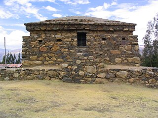
Kenko,Qenqo or Q'inq'u or also Inka Anatawi is an archaeological site in Peru. It is located in the Puno Region, Puno Province, Acora District, at an elevation of about 4,000 m (13,000 ft). The site was declared a National Cultural Heritage (Patrimonio Cultural) of Peru by the National Institute of Culture.
Mallkuamaya is an archaeological site in Peru. It is located in the Puno Region, Puno Province, Puno District, about 15 km southwest of Puno. The site was declared a National Cultural Heritage (Patrimonio Cultural) of Peru by the National Institute of Culture.
Intini Uyu Pata or Inti Uyu is an archaeological site in Peru. It is located in the Puno Region, Yunguyo Province, between the districts Ollaraya and Unicachi, at a height of about 3,867 m (12,687 ft). The site was declared a National Cultural Heritage (Patrimonio Cultural) of Peru by the National Institute of Culture.
Mirq'imarka is an archaeological site in Peru. It is located in the Puno Region, Moho Province, Moho District. The site was declared a National Cultural Heritage (Patrimonio Cultural) of Peru by the National Institute of Culture.

Qulu Qulu is an archaeological site in Peru. It is located in the Puno Region, Sandia Province, Patambuco District. The site was declared a National Cultural Heritage (Patrimonio Cultural) of Peru by the National Institute of Culture.

Molloko is an archaeological site in Peru. It is located in the Puno Region, Puno Province, Acora District, about 5 km south of the town of Acora, near the village of Molloco. The site was declared a National Cultural Heritage (Patrimonio Cultural) by the National Institute of Culture.

Cutimbo is an archaeological site with stone tombs (chullpa) and cave paintings in Peru.

Pukara, Puno is a town in the Puno Region, Lampa Province, Pucará District, Peru. It is located to the north-west of Lake Titicaca.
Tanqa Tanqa or Tanka Tanka is an archaeological site in Peru. It is located in the Puno Region, Chucuito Province, Zepita District. The site was declared a National Cultural Heritage (Patrimonio Cultural) of Peru.
Tupu Inka is an archaeological site in Peru. It is located in the Puno Region, Yunguyo Province, Unicachi District.
Killarumiyuq is an archaeological park in Peru. It is located in the Cusco Region, Anta Province, Ancahuasi District. The site was declared a National Cultural Heritage (Patrimonio Cultural) of Peru by Resolución Directoral Nacional No. 150/INC-2003 of March 25, 2003.

Pukara is a mountain in the Andes of Peru, about 4,200-metre (13,800 ft) high, with an archaeological site on top. It is located in the Puno Region, Sandia Province, Patambuco District, southwest of Patambuco. The pre-Inca funerary site is also known as Trinchera. The place was declared a National Cultural Heritage by Resolución Directoral Nacional No. 296/INC-2003 by the National Institute of Culture. It consists of tombs, walls, houses, squares and tunnels.


