Cusco, also spelled Cuzco, is a department in Peru. It is bordered by the departments of Ucayali on the north; Madre de Dios and Puno on the east; Arequipa on the south; and Apurímac, Ayacucho and Junín on the west. Its capital is Cusco, the capital of the Inca Empire.

Chinchero District is one of seven districts of the Urubamba Province in Peru. It is the location for the proposed Chinchero International Airport, which would serve travelers to the Cusco Region.
Cusichaca River, is a river in Peru located in the Cusco Region, Urubamba Province, on the border of the districts Machupicchu and Ollantaytambo. Its waters flow to the Vilcanota River.

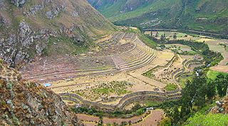
Patallacta, Llactapata or Q'ente Marka is an archaeological site in Peru located in the Cusco Region, Urubamba Province, Machupicchu District. It is situated southeast of the site Machu Picchu, at the confluence of the rivers Cusichaca and Vilcanota on a mountain named Patallacta.

Pumahuanca, Pumahuanja or Yucay is a 5,318-metre-high (17,448 ft) mountain in the Urubamba mountain range in the Andes of Peru. It is located in the Cusco Region, on the boundary between Calca and Urubamba provinces, northwest of Urubamba. It lies northwest of Chicón and west of Capacsaya.
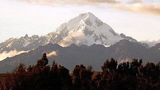
Veronica, also called Huacrahuilki, Huacay Huilcay, Wayna Willka,Waqaywillka, Urubamba, or Padre Eterno, is a 5,893 m (19,334 ft) mountain in the Urubamba mountain range in the Andes of Peru. It is located in the Cusco Region, La Convención Province, Huayopata District, and in the Urubamba Province, Ollantaytambo District northwest of the town of Ollantaytambo.
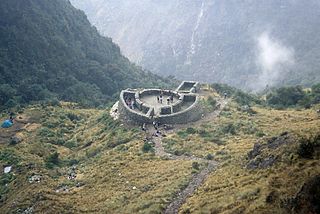
Runkuraqay or Runku Raqay is an archaeological site on a mountain of the same name in Peru located in the Cusco Region, Urubamba Province, Machupicchu District. It is situated southeast of the archaeological site Machu Picchu and south of the Vilcanota river. The ruins lie on the southern slope of the mountain Runkuraqay near the Runkuraqay pass, northeast of the archaeological site Sayacmarca and southeast of the site Qunchamarka.

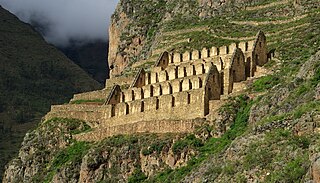
Huillca Raccay or Huillca Racay is an archaeological site in Peru located in the Cusco Region, Urubamba Province, Ollantaytambo District. It is situated southeast of the archaeological site Patallacta above the right bank of the little river Pampa Qhawa, an affluent of the Vilcanota River, near the village Chamana.
Pinkuylluna or Pinkulluna is an archaeological site on a mountain of the same name in Peru located in the Cusco Region, Urubamba Province, Ollantaytambo District. It is situated between the rivers Patakancha (Patacancha) and Willkanuta, northeast of the town Ollantaytambo.
Pumamarka is an archaeological site in Peru. It is located in the Cusco Region, Urubamba Province, Ollantaytambo District, at the confluence of the rivers Patakancha and its affluent Yuraqmayu.
Qurimarka is an archaeological site in Peru. It is located in the Cusco Region, Urubamba Province, Ollantaytambo District. It is situated at the river Rayanniyuq (Rayanniyoc) and it belongs to the community Rayanniyuq.
Ayawayq'u, also known as Yukay(Yucay) or Kapillayuq(Capillayoq) is an archaeological site with rock paintings in Peru. It is situated in the Cusco Region, Urubamba Province, Yucay District. The site lies at a height of about 3,100 metres (10,171 ft) on the southern side of the mountain Kapillayuq.
T'uqu T'uquyuq or Machu Machuyuq is an archaeological site with rock paintings in Peru. It is situated in the Cusco Region, Urubamba Province, Yucay District. The site lies at a height of about 3,150 metres (10,335 ft) on the slopes of the mountain Saywa (Sayhua).
Inkapintay or Inkapintayuq is an archaeological site in Peru with a rock painting. It is situated in the Cusco Region, Urubamba Province, Ollantaytambo District, near Ollantaytambo. The figure which draws the attention possibly depicts a noble person.

Huacratanca is a 5,024-metre-high (16,483 ft) mountain in the Urubamba mountain range in the Andes of Peru. It is located in the Cusco Region, Urubamba Province, Ollantaytambo District. It lies northwest of Salcayoc and Patacancha, and northeast of Huarmaripayoc.
Llamayojcasa, also known as Qochaqollur, is a mountain in the eastern extensions of the Urubamba mountain range in the Andes of Peru, about 4,600 m (15,092 ft) high. It is located in the Cusco Region, Calca Province, Calca District. It lies southeast of Ccerayoc. This is where the archaeological site of Llamayuq is situated.
Qosqoccahuarina is a private area of conservation in the Urubamba mountain range in the Andes of Peru. It is located in the Cusco Region, Urubamba Province, Ollantaytambo District. It lies in the community of Rumira Sondormayo at the Patacancha valley near Patacancha. The area of conservation of Qosqoccahuarina is recognized by Resolución Ministerial No. 089-2011-MINAM. The aim is to protect the Polylepis forest and its avifauna, the hydrographical basins of the community and the wild flora and fauna of the Andean highlands.
Llaulliyoc is a mountain north of the Urubamba mountain range in the Andes of Peru, about 4,400 m (14,400 ft) high. It is located in the Cusco Region, La Convención Province, Ocobamba District, and in the Urubamba Province, Ollantaytambo District.
Curcurorjo is a mountain in the Andes of Peru, about 4,400 m (14,400 ft) high. It is located in the Cusco Region, La Convención Province, Huayopata District, and in the Urubamba Province, Machupicchu District. Curcurorjo lies in the northwestern extensions of the Urubamba mountain range, northeast of the archaeological site of Machu Picchu.
Tunquiorjo is a mountain in the Andes of Peru, about 4,200 m (13,800 ft) high. It is located in the Cusco Region, La Convención Province, Huayopata District, and in the Urubamba Province, Machupicchu District. Tunquiorjo lies in the northwestern extensions of the Urubamba mountain range, northeast of the archaeological site of Machu Picchu.