
Antonio Raymondi is a province of the Ancash Region in Peru. It is located along the central eastern edge of the Ancash Region, bordering the Huánuco Region.

The Huari Province is one of twenty provinces of the Ancash Region in Peru. Its seat is Huari.
The Yungay Province is one of twenty provinces of the Ancash Region in Peru.

The Pomabamba Province is one of twenty provinces of the Ancash Region in Peru. It was formerly called Pumapampa and today it is also known as "The City of Cedars". It is located at the left bank of the Pomabamba river, at 3,063 meters (10,049 ft) above sea level. It was created by law on February 21, 1861.

Yuracmarca or Yuraq Marka is one of 10 districts of the Huaylas Province in the Ancash Region of Peru. The capital of the district is the village of Yuracmarca.
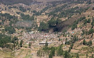
Huari is one of the 16 districts that integrates the Peruvian province of Huari in the Ancash region. The district consists of the city of Huari, 15 small villages and 22 annexes.
Cajay District is one of sixteen districts of the Huari Province in Peru.
Masin District is one of sixteen districts of the province Huari in Peru.
Pumaq Hirka is an archaeological site in Peru. It is situated in the Huánuco Region, Huamalíes Province, Miraflores District, at a height of about 3,696 metres (12,126 ft).
Warahirka or Wara Hirka is a mountain with an archaeological site of the same name in Peru. It is situated in the Huánuco Region, Yarowilca Province, Pampamarca District, about 1.5 km from Pampamarca, near La Florida and Warahirka (Huarajirca).

Qiwlla Hirka is a mountain in the southern part of the Cordillera Blanca in the Andes of Peru, about 5,000 m (16,000 ft) high. It is located in the Ancash Region, Recuay Province, Catac District. Qiwlla Hirka lies northeast of Qiwllarahu and Challwa, near Pastu Ruri.
Millu Hirka is a mountain in the Cordillera Blanca in the Andes of Peru, about 4,900 m (16,076 ft) high. It is situated in the Ancash Region, Huari Province, Huari District. Millu Hirka lies northeast of Antap'iti and southeast of Tullparahu. Milluqucha is the name of the lake north of the mountain.
Puka Hirka is a 4,870-metre-high (15,980 ft) mountain in the Cordillera Negra in the Andes of Peru. It is situated in the Ancash Region, Huaraz Province, on the border of the districts of Cochabamba and Pariacoto, and in the Yungay Province, Shupluy District. It lies southwest of Willka Wayin.
Puka Hirka is a mountain in the Cordillera Blanca in the Andes of Peru, about 4,800 m (15,700 ft) high. It is situated in the Ancash Region, Bolognesi Province, Aquia District, northeast of Pastururi.
Puka Hirka or Pukahirka may refer to:
Wayta Hirka Punta is a mountain in the Andes of Peru which reaches a height of approximately 4,400 m (14,400 ft). It is located in the Huánuco Region, Dos de Mayo Province, Marías District. Wayta Hirka Punta lies south of Tikti Punta and southeast of a lake named Saqsaqucha.
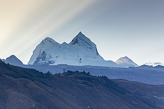
Putaqa Hirka is a mountain in the eastern extensions of the Cordillera Blanca in the Andes of Peru which reaches a height of approximately 4,200 m (13,800 ft). It is located in the Ancash Region, Huari Province, on the border of the districts of Cajay and Masin.
Quinuajirca or Kinwa Hirka is a mountain in the eastern extensions of the Cordillera Blanca in the Andes of Peru which reaches a height of approximately 4,400 m (14,400 ft). It is located in the Ancash Region, Huari Province, Huari District. Quinuajirca lies at the Rurichinchay valley, northeast of the peak of Chinchey.
Jatunjirca is a mountain in the eastern part of the Cordillera Blanca in the Andes of Peru which reaches a height of approximately 3,800 m (12,500 ft). It is located in the Ancash Region, Huari Province, Huari District, southwest of Huari and west of the village of Yacya.
Hatun Hirka may refer to:
