Cusco or Cuzco ) is a city in southeastern Peru near the Sacred Valley of the Andes mountain range and the Huatanay river. It is the capital of the Department of Cusco and of the Cusco Province. The city is the seventh most populous in Peru; in 2017, it had a population of 428,450. Its elevation is around 3,400 m (11,200 ft).

Machu Picchu is a 15th-century Inca citadel located in the Eastern Cordillera of southern Peru on a 2,430-meter (7,970 ft) mountain ridge. Often referred to as the "Lost City of the Incas", it is the most familiar icon of the Inca Empire. It is located in the Machupicchu District within Urubamba Province above the Sacred Valley, which is 80 kilometers (50 mi) northwest of Cusco. The Urubamba River flows past it, cutting through the Cordillera and creating a canyon with a tropical mountain climate. In reference to the site's name, for most English or Spanish speakers, the first 'c' in Picchu is silent. In English, the name is pronounced MAH-choo PEE-choo or MATCH-oo PEAK-choo, in Spanish as or, and in Quechua as.

Vilcabamba or Willkapampa, often called the Lost City of the Incas, is a lost city in the Echarate District of La Convención Province in the Cuzco Region of Peru. Vilcabamba means "sacred plain" in Quechua. The modern name for the Inca ruins of Vilcabamba is Espíritu Pampa.
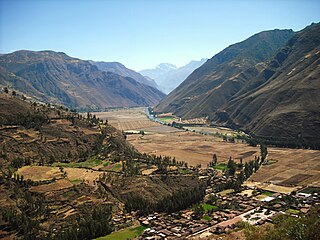
The Sacred Valley of the Incas, or the Urubamba Valley, is a valley in the Andes of Peru, north of the Inca capital of Cusco. It is located in the present-day Peruvian region of Cusco. In colonial documents it was referred to as the "Valley of Yucay." The Sacred Valley was incorporated slowly into the incipient Inca Empire during the period from 1000 to 1400.

Machupicchu or Machupicchu Pueblo, also known as Aguas Calientes, is a location in Peru situated in the Cusco Region, Urubamba Province. It is the seat of Machupicchu District. Machupicchu lies at the Vilcanota River. It is the closest access point to the historical site of Machu Picchu which is 6 kilometres (3.7 mi) away or about a 90-minute walk. There are many hotels and restaurants for tourists, as well as natural hot baths which gave the town its colloquial Spanish name, Aguas Calientes or hot water.

Huayna Picchu, Quechua: Wayna Pikchu, is a mountain in Peru around which the Urubamba River bends. It is located in the Cusco Region, Urubamba Province, Machupicchu District. It rises over Machu Picchu, the so-called lost city of the Incas. The Incas built a trail up the side of the Huayna Picchu and built temples and terraces on its top. The peak of Huayna Picchu is 2,693 metres (8,835 ft) above sea level, or about 260 metres (850 ft) higher than Machu Picchu.

The Temple of the Moon is an Incan ceremonial temple on Huayna Picchu near Machu Picchu, in Peru. The site is made up of stone masonry and an open-face, shallow cave. The temple is arbitrarily named, like many of the sites in Machu Picchu.

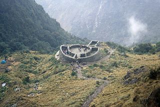
The Inca Bridge or Inka Bridge refers to one of two places related to access to Machu Picchu, in Peru.

Choquequirao is an Incan site in southern Peru, similar in structure and architecture to Machu Picchu. The ruins are buildings and terraces at levels above and below Sunch'u Pata, the truncated hill top. The hilltop was anciently leveled and ringed with stones to create a 30 by 50 m platform.

Canchis Province is one of thirteen provinces in the Cusco Region in the southern highlands of Peru.

The Lares trek is a two- or three-day high-altitude hike in Cusco, Peru, starting near the village Lares, approximately 40 mi (64 km) north of Cusco and 35 mi (56 km) east of Machu Picchu. The Lares Valley lies in the east of the Urubamba mountain range, traversing part of the Sacred Valley. Reaching the start of the trek requires a bus or van trip of approximately five hours from the village of Lares. The trek route transverses typical Peruvian Andean mountain areas.

Tambomachay is an archaeological site associated with the Inca Empire, located near Cusco, Peru. An alternate Spanish name is El Baño del Inca.

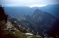
The Inca Trail to Machu Picchu is a hiking trail in Peru that terminates at Machu Picchu. It consists of three overlapping trails: Mollepata, Classic, and One Day. Mollepata is the longest of the three routes with the highest mountain pass and intersects with the Classic route before crossing Warmiwañusqa. Located in the Andes mountain range, the trail passes through several types of Andean environments including cloud forest and alpine tundra. Settlements, tunnels, and many Incan ruins are located along the trail before ending the terminus at the Sun Gate on Machu Picchu mountain. The two longer routes require an ascent to beyond 4,200 metres (13,800 ft) above sea level, which can result in altitude sickness.

Patallacta, Llactapata or Q'ente Marka is an archaeological site in Peru located in the Cusco Region, Urubamba Province, Machupicchu District. It is situated southeast of the site Machu Picchu, at the confluence of the rivers Cusichaca and Vilcanota on a mountain named Patallacta.

Intihuatana at the archaeological site of Machu Picchu is a notable ritual stone associated with the astronomic clock or calendar of the Inca in South America. Machu Picchu was thought to have been built c. 1450 by the Sapa Inca Pachacuti as a country estate. In the late 16th century, the Viceroy Francisco de Toledo and the clergy destroyed those Intihuatana which they could find. They did so as they believed that the Incas' religion was a blasphemy and the religious significance of the Intihuatana could be a political liability. The Intihuatana of Machu Picchu was found intact by Bingham in 1911, indicating that the Spanish conquerors had not found it. Intihuatana was damaged on September 8, 2000 when a crane being used in an ad shoot toppled over and chipped off a piece of the granite.

Warmi Wañusqa is a mountain pass in the Cusco Region in Peru. It is located in the Urubamba Province, Machupicchu District. Warmi Wañusqa lies on the Inca Trail to Machu Pikchu, southwest of the archaeological site of Patallaqta. It is situated at a height of 4,200 metres (13,780 ft).
Runkuraqay or Runku Raqay is an archaeological site on a mountain of the same name in Peru located in the Cusco Region, Urubamba Province, Machupicchu District. It is situated southeast of the archaeological site Machu Picchu and south of the Vilcanota river. The ruins lie on the southern slope of the mountain Runkuraqay near the Runkuraqay pass, northeast of the archaeological site Sayacmarca and southeast of the site Qunchamarka.

Sayacmarca is an archaeological site in Peru located in the Cusco Region, Urubamba Province, Machupicchu District. It is situated southwest of the archaeological site Runkuraqay and the Runkuraqay pass and southeast of the sites Phuyupatamarka and Qunchamarka.

Qunchamarka is an archaeological site in Peru located in the Cusco Region, Urubamba Province, Machupicchu District, southwest of the mountain Runkuraqay. It lies between the archaeological sites Sayaqmarka and Phuyupatamarka on the Inca Trail to Machu Picchu.
Purunllacta or Purum Llacta (Quechua purum, purun savage, wild / wasteland, llaqta place is an archaeological site of the Chachapoya culture in Peru. It is situated in the Amazonas Region, Chachapoyas Province, Cheto District, on the mountain of the same name. It lies northeast and near the archaeological site of Purunllacta of the Soloco District.