Marcahuamachuco

Last updated
Marcahuamachuco
Marcahuamachuco- Plaza Principal (Sector El Castillo).jpg
Marcahuamachuco- Plaza Principal (Sector El Castillo), Huamachuco
Peru location map.svg
Archaeological site icon (red).svg
Map showing location of the Marcahuamachuco's Inca ruins in Peru
Location La Libertad Region, Peru
Coordinates 7°47′07″S78°04′42″W / 7.7853°S 78.0783°W / -7.7853; -78.0783
History
Founded15th century
Cultures Pre-Incan

Marcahuamachuco is an archeological site of Pre-Incan ruins in the La Libertad Region of Peru. Although less well-known than other sites, it is considered significant and has been referred to by archaeologists as "Machu Picchu of the North" and "The Jewel of La Libertad." [1]

Contents

History

Marcahuamachuco, Muros del Castillo Marcahuamachuco- Detalles de muros del Castillo.jpg
Marcahuamachuco, Muros del Castillo

Construction of Marcahuamachuco began around AD 400, during the Andean Middle Horizon period and continued until approximately 800 AD. This was well before the Wari culture and the later imperial expansion of the Incas. Before being conquered by the Incas in the 14th century, Marcahuamachuco was known as northern Peru's most important political, economic and military center. [2]

Researchers believed that the site as an oracle center, and for religious and political ceremonies. In the later stages of the culture, it was used as a burial site for the elite. Its influence extended through much of northern Peru and contemporary southern Ecuador. This importance may have been related to trade with its neighbors between AD 650 and 700, the Mochica to the west, the Recuay culture to the south, Cajamarca in the north and lesser-known cultures of the Maranon.

Built defensively on top of an isolated highland mesa that is 5 kilometers long and 500 meters wide, with a vast view of the surroundings, Marcahuamachuco contains several major compounds. These were surrounded by curved stone walls as high as 12 meters. The remains of inner galleries, rooms and plazas suggest administrative and ceremonial functions. During the later Middle Period (AD 700–900) followed into the Intermediate Late Horizon (until around 1200), archaeological evidence suggests that human burials were made within the walls. These contributed to the ceremonial functions of the site.

Marcahuamachuco probably had oracles, who attracted people from the northern Andes, the areas that today comprise Peru and Ecuador. The cult was probably related to deities, an old cult to Ataujo, and a more recent cult to Catequil. Marcahuamachuco became a prominent center at the same time that the Wari in southern Peru culture flourished (AD 400 – 1100). The site was likely abandoned in the 15th century.

The latest investigations of the site by researchers John and Theresa Lange Topic (1991) suggested that occupation may have been seasonal, with a maximum population of 6,000. Their estimate is based upon the quantity of arable land and water availability. [3]

Investigations

Marcahuamachuco-(Sector Las Monjas) Marcahuamachuco- Sector Las Monjas.jpg
Marcahuamachuco-(Sector Las Monjas)

One of the earliest sketch maps on Marcahuamachuco comes from the 18th-century document prepared by Bishop Baltazar Jaime Martinez Compañón. Early descriptions and drawings from the late 19th century were done by European travelers, as the field of archeology was developing professionally. Charles Wiener in 1880 published the first topographical description of Marcahuamachuco and named its principal compounds. [4] Ernst Middendorf visited Marcahuamachuco in 1887, describing its principal compounds and comparing the site to Kuelap. [5] [6]

The first formal archaeological research in Marcahuamachuco was conducted during three months in 1900 by Max Uhle and Julio C. Tello under the auspices of the University of California, Berkeley (UC). Uhle photographed the site and corrected the previous maps prepared by Wiener. [7] His research was followed in 1941-42 by Theodore McCown of UC. In addition to reviewing Uhle's writings and collected specimens stored at the University's Museum of Anthropology, during two years of field work McCown excavated between the monumental galleries. His publication described the site in more detail, and he drew more precise and elaborate maps of the archaeological site, and presented a chronological sequence to explain the cultural development of Marcahuamachuco. [8]

In 1944 archaeologist Hans Horkheimer published photographs from Marcahuamachuco, which showed stone heads similar to those of Chavin. John Thatcher, a student of McCown, continued with research in the site during 1968-69 and 1973–74. He worked to establish its cultural phases and chronologies on the basis of ceramic styles.

The Huamachuco Archaeological Project, supported by a Canadian team, has been dedicated since 1981 to study the prehistory of the area. Its researchers have collected data and drawn conclusions about the site and its history.

The Site

Marcahuamachuco is set atop the nexus of three mountain valleys at an altitude of more than 3,200 meters (10,000 feet). Encompassing more than three kilometres of land, the site is celebrated for its massive castillos and unique circular double-walled archaeological structures. Over many centuries, however, the ruins have been degraded by natural elements, and today face accelerating threats from grazing livestock, plant growth, lack of conservation and surveillance, and the continued effects of natural elements and weather. The site's location, in the northern Peruvian highlands of La Libertad, was until recently a difficult to access place. Today a new road makes it accessible on three and a half hours ride from the city of Trujillo, the third largest on the country's Pacific coast, and location of major Moche heritage sites.

The domestic residences are multi-storied galleries which originally housed numerous individual families. [9]

Conservation

The massiveness and monumentality of the Marcahuamachuco complex reveals the importance of its constructions and their function, a factor that has moved the Peruvian Government to support the conservation of this immense archaeological site by recently establishing funding for a major project for conservation of what visitors have denominated “The Machu Picchu of the North”. More recently the Minister of Culture Juan Ossio denotes the importance of the site and names Marcahuamachuco, Wanuku Pampa and Kuelap as the major archaeological tourist destinations, at equal level to Machu Picchu.

In May 2011, Global Heritage Fund (GHF) announced that it will provide funding and technical expertise for a conservation at Marcahuamachuco. [10]

Related Research Articles

<span class="mw-page-title-main">Machu Picchu</span> 15th-century Inca citadel in Peru

Machu Picchu is a 15th-century Inca citadel located in the Eastern Cordillera of southern Peru on a 2,430-meter (7,970 ft) mountain ridge. Often referred to as the "Lost City of the Incas", it is the most familiar icon of the Inca Empire. It is located in the Machupicchu District within Urubamba Province above the Sacred Valley, which is 80 kilometers (50 mi) northwest of Cusco. The Urubamba River flows past it, cutting through the Cordillera and creating a canyon with a tropical mountain climate. In reference to the site's name, for most English or Spanish speakers, the first 'c' in Picchu is silent. In English, the name is pronounced MAH-choo PEE-choo or MATCH-oo PEAK-choo, in Spanish as or, and in Quechua as.

Viracocha is the great creator deity in the pre-Inca and Inca mythology in the Andes region of South America. According to the myth Viracocha had human appearance and was generally considered as bearded. According to the myth he ordered the construction of Tiwanaku. It is also said that he was accompanied by men also referred to as Viracochas.

<span class="mw-page-title-main">Inca road system</span> Transportation system of the Inca empire

The Inca road system was the most extensive and advanced transportation system in pre-Columbian South America. It was about 40,000 kilometres (25,000 mi) long. The construction of the roads required a large expenditure of time and effort.

<span class="mw-page-title-main">Department of La Libertad</span> Department in 12 provinces and 83 districts, Peru

La Libertad is a department and region in northwestern Peru. Formerly it was known as the Department of La Libertad. It is bordered by the Lambayeque, Cajamarca and Amazonas regions on the north, the San Martín Region on the east, the Ancash and Huánuco regions on the south and the Pacific Ocean on the west. Its capital is Trujillo, which is the nation's third biggest city. The region's main port is Salaverry, one of Peru's largest ports. The name of the region is Spanish for "freedom" or "liberty"; it was named in honor of the Intendancy of Trujillo's proclaiming independence from Spain in 1820 and fighting for that. It is the ninth smallest department in Peru, but it is also its second-most populous department after Piura and its second-most densely populated department after Lambayeque.

<span class="mw-page-title-main">Chan Chan</span> City of the pre-Columbian era in South America

Chan Chan, sometimes itself called Chimor, was the capital city of the Chimor kingdom. It was the largest city of the pre-Columbian era in South America. It is now an archeological site in the department of La Libertad five kilometers (3.1 mi) west of Trujillo, Peru.

<span class="mw-page-title-main">Chachapoya culture</span> Andean culture

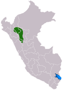
The Chachapoyas, also called the "Warriors of the Clouds", was a culture of the Andes living in the cloud forests of the southern part of the Department of Amazonas of present-day Peru. The Inca Empire conquered their civilization shortly before the Spanish conquest in the 16th century. At the time of the arrival of the conquistadors, the Chachapoyas were one of the many nations ruled by the Incas, although their incorporation had been difficult due to their constant resistance to Inca troops.

<span class="mw-page-title-main">Ollantaytambo</span> Archaeological site in Peru

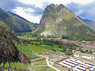
Ollantaytambo is a town and an Inca archaeological site in southern Peru some 72 km (45 mi) by road northwest of the city of Cusco. It is located at an altitude of 2,792 m (9,160 ft) above sea level in the district of Ollantaytambo, province of Urubamba, Cusco region. During the Inca Empire, Ollantaytambo was the royal estate of Emperor Pachacuti, who conquered the region, and built the town and a ceremonial center. At the time of the Spanish conquest of Peru, it served as a stronghold for Manco Inca Yupanqui, leader of the Inca resistance. Located in the Sacred Valley of the Incas, it is now an important tourist attraction on account of its Inca ruins and its location en route to one of the most common starting points for the four-day, three-night hike known as the Inca Trail.

<span class="mw-page-title-main">Kuélap</span> Archaeological site in Peru

Kuélap or Cuélap is a walled settlement located in the mountains near the towns of María and Tingo, in the southern part of the region of Amazonas, Peru. It was built by the Chachapoyas culture in the 6th century AD on a ridge overlooking the Utcubamba Valley.

<span class="mw-page-title-main">Architecture of Peru</span>

Peruvian architecture is the architecture carried out during any time in what is now Peru, and by Peruvian architects worldwide. Its diversity and long history spans from ancient Peru, the Inca Empire, Colonial Peru to the present day.

<span class="mw-page-title-main">Huamachuco District</span> District in La Libertad, Peru

Huamachuco District is one of the districts of the Sánchez Carrión province located in La Libertad Region in Peru. It contains the capital of the province and the important archeological site of Marcahuamachuco, which was active, likely as an oracle center and place for religious and political elites, about 350 CE to 1100 CE.

<span class="mw-page-title-main">Sánchez Carrión Province</span> Province of Peru

The Sánchez Carrión Province, known until 1976 as Huamachuco Province, is one of twelve provinces of the La Libertad Region in Peru. It is named in honour of José Faustino Sánchez Carrión. The capital of this province is the city of Huamachuco. About 30 miles away is Marcahuamachuco, a prehistoric political and religious centre of a culture that throve AD 350-1100.

<span class="mw-page-title-main">Huamachuco</span> Town in La Libertad, Peru

Huamachuco is a town in northern Peru and capital of the province Sánchez Carrión in La Libertad Region. The city is the seat of the Territorial Prelature of Huamachuco. Lake Sausacocha lies to the northeast.

<span class="mw-page-title-main">Inti Punku</span> Archaeological site in Peru

Inti Punku or Intipunku is an archaeological site in the Cusco Region of Peru that was once a fortress of the sacred city, Machu Picchu. It is now also the name of the final section of the Incan Trail between the Sun Gate complex and the city of Machu Picchu. It was believed that the steps were a control gate for those who enter and exited the Sanctuary.

<span class="mw-page-title-main">Viracochapampa</span> Archaeological site in Peru

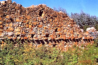
Viracochapampa, Huiracochapampa, or Wiracochapampa is an archaeological site with the remains of a building complex of ancient Peru of pre-Inca times. It was one of the administrative centers of the Wari culture. Viracochapampa is located about 3.5 km north of Huamachuco in the region of La Libertad at an elevation of 3,070 metres (10,072 ft).

<span class="mw-page-title-main">Intihuatana</span>

Intihuatana is a ritual stone in South America associated with the astronomic clock or calendar of the Inca. Its name is derived from the local Quechua language. The most notable Intihuantana is an archaeological site located at Machu Picchu in the Sacred Valley near Machu Picchu, Peru. The name of the stone is derived from Quechua: inti means "sun", and wata- is the verb root "to tie, hitch (up)". The Quechua -na suffix derives nouns for tools or places. Hence inti watana is literally an instrument or place to "tie up the sun", often expressed in English as "The Hitching Post of the Sun".

Pirca Pirca is an archaeological site in Peru. It is located in the La Libertad Region, Bolívar Province, Uchumarca District. Pirca Pirca was declared a National Cultural Heritage of Peru by the National Institute of Culture by Resolución Directoral Nacional No. 075-INC on December 30, 1998. The site lies on top of the mountain named Pirca Pirca.

Alexei Vranich is an American archaeologist specializing in the pre-Columbian South America. His previous positions include Visiting Professor at the University of Warsaw, Poland (2021-22), Lecturer at the Department of Material Sciences at MIT (2021-22), Research Associate, and Assistant Dean at Bowles Hall Residential College (2016-18) at the University of California, Berkeley, Research Associate and Visiting Assistant Professor (2009-2015) at UCLA, and a Lecturer and Research Associate at the University of Pennsylvania from 1999 to 2004. He received his B.A. from the University of California, Berkeley in 1990 and his Ph.D. from the University of Pennsylvania in 1999. He is a Fulbright Scholar and Dumbarton Oaks Harvard Fellow. Vranich is presently teaching and conducting research at the University of Warsaw, Poland.

Nicola Masini is an Italian scientist with CNR, noted for his work on exploring traces of Andean civilizations in Peru and Bolivia using spatial technologies and Remote Sensing.

References

  1. "Marcahuamachuco", Arqueologia, Peru
  2. "Marcahuamachuco", Living in Peru
  3. Topic, Theresa Lange (1991). "The Meaning of Monuments at Marcahuamachuco," 55th Annual Meeting of the Society for American Archaeology. New Orleans: Abril
  4. Wiener, Charles (1880). Pérou et Bolivie, Paris: Librarie Hachette et Cie.
  5. Middendorf, Ernst Wihelm (1893). "1893Beobachtungen und Studien über das Land und seine Bewohner während eines 25 Jährigen Aufenthalts." Berlin
  6. Middendorf, Ernst Wihelm (1895). Peru Vol. III, Das Hochland Berlin: Robert Oppenheim.
  7. Uhle, Max (1900). "Carta a la Señora Phoebe A. Hearst," Universidad de California.
  8. McCown, Theodore D. (1945). The Pre-Incaic Site of Huamachuco, University of California Publications in American Archaeology and Ethnology, 1945
  9. Topic, Theresa Lange (1991). "The Meaning of Monuments at Marcahuamachuco". 55th Annual Meeting of the Society for American Archaeology. New Orleans: Abril
  10. Archived Global Heritage Fund to support Marcahuamachuco archaeological site conservation at the Wayback Machine (archived 2011-06-01)