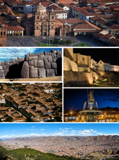
Cusco, often spelled Cuzco[ˈkusko], is a city in southeastern Peru near the Urubamba Valley of the Andes mountain range. It is the capital of the Cusco Region and of the Cusco Province. The city is the seventh most populous in Peru, and, in 2017, it had a population of 428,450. Its elevation is around 3,400 m (11,200 ft).

Machu Picchu is a 15th-century Inca citadel, located in the Eastern Cordillera of southern Peru, on a 2,430-metre (7,970 ft) mountain ridge. It is located in the Machupicchu District within Urubamba Province above the Sacred Valley, which is 80 kilometres (50 mi) northwest of Cuzco. The Urubamba River flows past it, cutting through the Cordillera and creating a canyon with a tropical mountain climate.

Lake Titicaca is a large, deep, freshwater lake in the Andes on the border of Bolivia and Peru, often called the "highest navigable lake" in the world. By volume of water and by surface area, it is the largest lake in South America.

Vilcabamba, Willkapampa is often called the Lost City of the Incas. Vilcabamba means "sacred plain" in Quechua. The modern name for the Inca ruins of Vilcabamba is Espiritu Pampa. Vilcabamba is located in Echarate District of La Convención Province in the Cuzco Region of Peru.
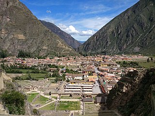
Ollantaytambo is a town and an Inca archaeological site in southern Peru some 72 km (45 mi) by road northwest of the city of Cusco. It is located at an altitude of 2,792 m (9,160 ft) above sea level in the district of Ollantaytambo, province of Urubamba, Cusco region. During the Inca Empire, Ollantaytambo was the royal estate of Emperor Pachacuti, who conquered the region, and built the town and a ceremonial center. At the time of the Spanish conquest of Peru, it served as a stronghold for Manco Inca Yupanqui, leader of the Inca resistance. Nowadays, located in what is called the Sacred Valley of the Incas, it is an important tourist attraction on account of its Inca ruins and its location en route to one of the most common starting points for the four-day, three-night hike known as the Inca Trail.

The Chincha culture consisted of a Native Peruvian people living near the Pacific Ocean in south west Peru. The Chincha Kingdom and their culture flourished in the Late Intermediate Period, also known as the regional states period of pre-Columbian Peru. They became part of the Inca Empire around 1480. They were prominent as sea-going traders and lived in a large and fertile oasis valley. La Centinela is an archaeological ruin associated with the Chincha. It is located near the present-day city of Chincha Alta.
Paititi is a legendary Inca lost city or utopian rich land. It allegedly lies east of the Andes, hidden somewhere within the remote rainforests of southeast Peru, northern Bolivia or northwest Brazil. The Paititi legend in Peru revolves around the story of the culture-hero Inkarri, who, after he had founded Q'ero and Cusco, retreated toward the jungles of Pantiacolla to live out the rest of his days in his refuge city of Paititi. Other versions of the legend see Paititi as an Inca refuge in the border area between Bolivia and Brazil.

The Temple of the Moon is an Incan ceremonial temple on Huayna Picchu near Machu Picchu, in Peru. The site is made up of stone masonry and an open-face, shallow cave. The temple is arbitrarily named, like many of the sites in Machu Picchu.

Písac or Pisac is a Peruvian village in the Sacred Valley of the Incas. It is situated on the Vilcanota River. Pisac is most known for its Incan ruins and large market every Sunday, Tuesday, and Thursday, an event which attracts heavy tourist traffic from nearby Cusco.

Choquequirao is an Incan site in southern Peru, similar in structure and architecture to Machu Picchu. The ruins are buildings and terraces at levels above and below Sunch'u Pata, the truncated hill top. The hilltop was anciently leveled and ringed with stones to create a 30 by 50 m platform.

Tambomachay is an archaeological site associated with the Inca Empire, located near Cusco, Peru. An alternate Spanish name is El Baño del Inca.

Inti Punku or Intipunku is an archaeological site in the Cusco Region of Peru that was once a fortress of the sacred city, Machu Picchu. It is now also the name of the final section of the Incan Trail between the Sun Gate complex and the city of Machu Picchu. It was believed that the steps were a control gate for those who enter and exited the Sanctuary.

The Inca Trail to Machu Picchu is a hiking trail in Peru that terminates at Machu Picchu. It consists of three overlapping trails: Mollepata, Classic, and One Day. Mollepata is the longest of the three routes with the highest mountain pass and intersects with the Classic route before crossing Warmiwañusqa. Located in the Andes mountain range, the trail passes through several types of Andean environments including cloud forest and alpine tundra. Settlements, tunnels, and many Incan ruins are located along the trail before ending the terminus at the Sun Gate on Machu Picchu mountain. The two longer routes require an ascent to beyond 4,200 metres (13,800 ft) above sea level, which can result in altitude sickness.

Tipón, is a sprawling early fifteenth-century Inca construction that is situated at 3,400 meters above sea level. The complex covers 239 hectares and is located 22 kilometers southeast of Cusco near the town of Tipón. It consists of wide agricultural terraces irrigated by a network of water channels fed by a natural spring. Several surrounding ruins have been excavated, and many more are visible below the soil.
The Andean civilizations were complex societies of many cultures and peoples mainly developed in the river valleys of the coastal deserts of Peru. They stretched from the Andes of southern Colombia southward down the Andes to Chile and northwest Argentina. Archaeologists believe that Andean civilizations first developed on the narrow coastal plain of the Pacific Ocean. The Caral or Norte Chico civilization of Peru is the oldest known civilization in the Americas, dating back to 3200 BCE.

Patallacta, Llactapata or Q'ente Marka is an archaeological site in Peru located in the Cusco Region, Urubamba Province, Machupicchu District. It is situated southeast of the site Machu Picchu, at the confluence of the rivers Cusichaca and Vilcanota on a mountain named Patallacta.

Intihuatana at the archaeological site of Machu Picchu is a notable ritual stone associated with the astronomic clock or calendar of the Inca in South America. Machu Picchu was thought to have been built c. 1450 by the Sapa Inca Pachacuti as a country estate, although it is equally likely that the Inca discovered much older ruins and opted to build this majestic estate on older foundations.. In the late 16th century, the Viceroy Francisco de Toledo and the clergy destroyed those Intihuatana which they could find. They did so as they believed that the Incas' religion was a blasphemy and the religious significance of the Intihuatana could be a political liability. The Intihuatana of Machu Picchu was found intact by Bingham in 1911, indicating that the Spanish conquerors had not found it.
Rumicolca is an archaeological site in Peru. It is located in the Cusco Region, Quispicanchi Province, Lucre District. Rumicolca is situated near the archaeological sites Chuqi Pukyu and Pikillaqta, east of Lake Huacarpay.

Sayacmarca is an archaeological site in Peru located in the Cusco Region, Urubamba Province, Machupicchu District. It is situated southwest of the archaeological site Runkuraqay and the Runkuraqay pass and southeast of the sites Phuyupatamarka and Qunchamarka.

Purunllacta or Purum Llacta (Quechua purum, purun savage, wild / wasteland, llaqta place is an archaeological site of the Chachapoya culture in Peru. It is situated in the Amazonas Region, Chachapoyas Province, Cheto District, on the mountain of the same name. It lies northeast and near the archaeological site of Purunllacta of the Soloco District.

